Many of us were sad to see the demolition of the historic mansion that housed the Christy’s & Lenhardt’s restaurant in Clifton Heights. At the time, a new six-story, mixed-use development was envisioned for the site, which would have included 210 student apartments, street-level retail, and a 245-space parking structure. However, the Business Courier reports that the development has now been downsized by its developers, although the size of the parking structure has curiously been increased:
The developer is now looking to build a mixed-use building on the 1.65-acre site with about 190 apartment units, according to materials filed with the City Planning Commission. The building will have two levels of underground parking with 380 spaces. A row of six, three-story townhouses with separate entrances will face Lyon Street. Finally, a separated commercial space of up to 9,000 square feet will be at the corner Clifton and West McMillan streets. […]
At this point, the proposed schedule for the project includes zoning in the third and fourth quarters of 2014, permitting in the first quarter of 2015, construction starting in the second quarter of 2015, completion in July 2016 and occupancy in August 2016.
Overpass at North Highland Avenue [Atlanta BeltLine]
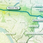
Following the guidance of City Council, Cincinnati’s Department of City Planning & Buildings has completed its land use study for the Wasson Railroad Corridor. The study’s findings and recommendations offer the clearest guidance to-date as to how to proceed with redeveloping the abandoned freight rail corridor, following the issuance of preliminary designs in July 2014.
City planners took a comprehensive look at the history of the corridor, its current conditions and the best path forward that respects the desires of the city and the impacted neighborhoods.
In that analysis City staff revealed seven studies and plans that recommend the corridor either be used for rail transit, or a combined multi-modal network that accommodates rail transit, bicycles and pedestrians. Some of the most notable of these include the 2002 MetroMoves regional transit plan, 2010 Bicycle Transportation Plan, 2012 comprehensive Plan Cincinnati, and the 2013 Railroad Safety Improvement Plan – all of which either specifically call for the corridor to be used for rail transit, or a multi-modal corridor.
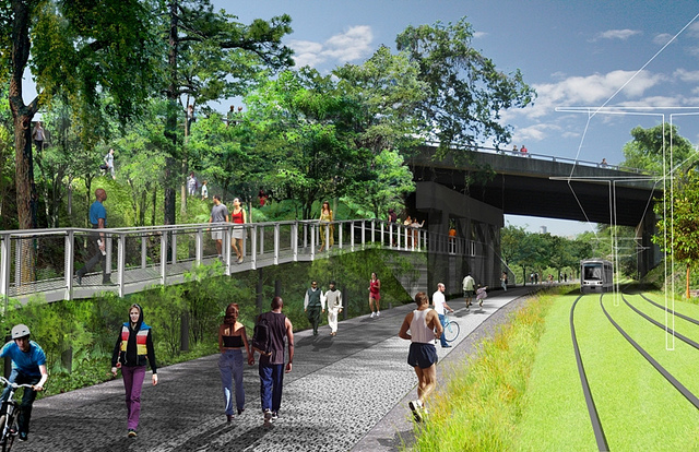
Wasson Way Trail [Provided]
The history is important as it influenced the study’s recommendation as to how to proceed with acquiring and preserving the corridor. As of now, the 5.7-mile Wasson Railroad Corridor is still owned by Norfolk Southern, but the City of Cincinnati has stated that they are in the process of acquiring the property from them.
“With this corridor being so crucial to the future development of multi-modal transportation in the City, the threat of potential development within the railroad right-of-way would significantly slow down, if not completely hinder, those possible public transportation opportunities from occurring,” city planners wrote in the 32-page land use study released earlier this month.
Of course, this fact has been known by policy makers at City Hall for years. As a result, City Council has, on several occasions, approved interim development controls to protect the corridor from being built upon. These controls, however, are just temporary and city officials must now decide how they would like to move forward.
In the study city planners examined the pros and cons of three potential options for accomplishing this.
The first option examined the idea of rezoning the property to a Parks and Recreation classification. This would offer the corridor significant protections, but it would also severely restrict the City from being able to implement rail transit in the future due to federal regulations that prohibit the use of public parks or wildlife refuges for transit corridors.
A second option studied looked at simply dedicating the land as City right-of-way. This too would offer significant protections, but is not possible until the City acquires the land from Norfolk Southern.
The third option, and the one recommended by city staff, is enacting a Transportation Overlay District over the corridor. While planners admit that crafting the language for such legislation may be complicated, they also stated that it would be most aligned with the preferences of neighborhood residents and publicly adopted planning documents.
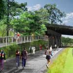
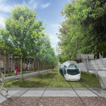
In order to address the complexity of the legislation required for such an overlay district, city planners recommended looking at the Atlanta BeltLine Overlay District that was implemented to protect a 22-mile abandoned freight rail corridor. In Atlanta civic leaders are currently in the process of converting the corridor into a similarly envisioned multi-modal network with rail transit, bikeways, parks and pedestrian paths.
The Square at Ford Factory Lofts [Atlanta BeltLine]
Overpass at North Highland Avenue [Atlanta BeltLine]
Irwin Promenade [Atlanta BeltLine]
“While all options present advantages and disadvantages, the Transportation Overlay District is seen as the best solution for preservation of the Wasson Railroad Corridor,” city planners wrote. “This tool, while it may take a bit longer to craft the ordinance language, will provide more flexibility and also protect the contiguous nature of the corridor.”
City officials say that this solution will allow for the development of the Wasson Way Trail to move forward in the near term, while affirming the City’s intentions to develop the corridor as a multi-modal transportation facility that includes rail transit in the future.
The solution crafted by the Department of City Planning & Buildings appears to be a perfect compromise between the two constituencies looking to use the corridor. Bicycle advocacy groups can see the right-of-way acquired and preserved so that they can move forward with their plans for a bike and pedestrian trail, while transit advocates can rest assure that those immediate efforts are not being done in conflict with ongoing planning and design work for a future light rail line.
With the Wasson Railroad Corridor Land Use Study now complete, it will go before the city’s Planning Commission. Should it be approved by Planning Commission, it will then go back to city staffers so that draft overlay district language can be crafted and recommended to City Council. From there, it would go before City Council for approval.
It is a standard process and one that advocates hope can be completed in the coming months.
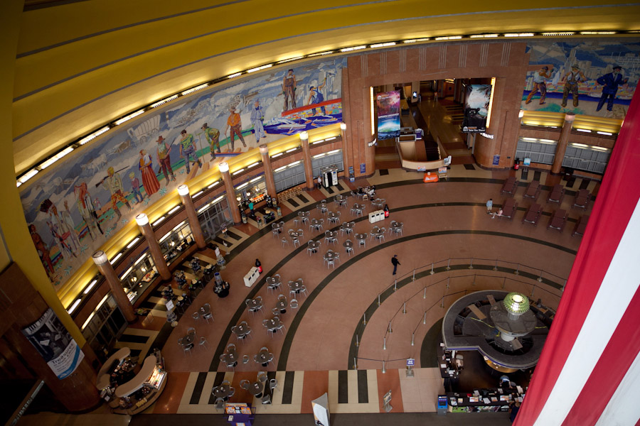
Cincinnati’s Union Terminal is one of the few remaining gems of its kind. In addition to being a part of the golden era for passenger rail travel, the grand structure also pioneered the modern, long-distance travel building architecture for many of today’s airports.
Built the 1933, the impressive Art Deco structure was originally designed by Steward Wagner and Alfred Fellheimer as a passenger rail station. When it opened it even included a large terminal building that extended over the railroad tracks below.
Entrance to Union Terminal
Union Terminal’s Rotunda
Union Terminal’s Clock
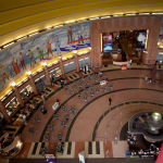
HVAC System
HVAC System
Outdated Windows
Radiator and AC Unit
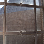
Structural Damage
Water Damage
Front Windows
Water Damage
After train service was drastically reduced in 1971, the building began to languish. Shortly thereafter, freight railroad companies moved in to acquire some of the land and the terminal building was removed. Facing imminent demolition approximately one decade later, Hamilton County voters approved a bond levy to restore the structure.
When renovations were complete in 1990, some passenger rail operations were restored and what we know of today as the Museum Center moved in. However, not much has been done to maintain the building since that time and even those repairs that were done in the late 1980s were only some of what was needed. That means the building is once again in need of an overall in order to stay in use.
On Tuesday, November 4, Hamilton County voters will once again decide the fate of one of the region’s most prominent landmarks. They will go to the polls to decide whether they want to initiate a quarter-cent sales tax to provide up to $170 million for the $208 million project.
To get a better idea of the current conditions of Union Terminal, I took a behind the scenes tour of the facility two weeks ago. There is noticeable water damage throughout the building, some visible structural damage and outdated HVAC systems that are driving up maintenance costs for the behemoth structure.
Whether this particular region icon is saved once more by the voters of Hamilton County, or not, is something we will soon find out.
EDITORIAL NOTE: All 11 photos were taken by Jake Mecklenborg for UrbanCincy on Saturday, September 27.
Just about a year ago, a new food delivery service entered the Cincinnati market. The idea behind it was one not uncommon in other larger urban centers around the country, but was new to the area.
While it can be simple to get sandwiches, pizza, or Chinese food delivered locally, that tends to be the limit of your options. But Robbie Sosna, who had lived Miami, New York City and Los Angeles after growing up in Blue Ash, knew the city could do better. So he launched Cincybite last December.
What Cincybite does is partner with area restaurants to deliver their regular menu items to hungry customers around the city. Sosna said they first started with just six restaurant partners and delivered only during dinner time in the center city. However, after a strong start, Cincybite quickly added lunch delivery options and added an additional seven restaurant partners within two weeks after their initial launch.
The early success of the business is yet another example of the retail services not keeping pace with the city’s population growth. While the age-old idea of ‘retail follows rooftops’ may still be true, technology is also now allowing some of that to be bypassed through innovative on-demand delivery services.
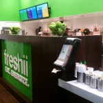
Freshii [Thadd Fiala]
Crave [Thadd Fiala]
“In New York and LA there were restaurant delivery services, and I was surprised to find none existed in town,” Sosna explained. “The response has been phenomenal and I’m working hard to expand the service through the metro area.”
This is not his first foray into the food industry. In 2009, he purchased his first Freshii franchise in Los Angeles before ultimately moving those operations to Cincinnati and bringing the popular fresh food chain to the region in 2012.
Cincybite’s offices are located downtown and are currently staffed by six employees who are tracking all sorts of data and usage patterns. The data they are collecting, Sosna says, is what is helping them determine what other restaurants to approach, types of food to add, and which areas to expand to next.
One area that has not yet been officially added to Cincybite’s delivery area is the city’s west side neighborhoods, but they say it is only a matter of time, and drivers, before that happens. As for now, the focus remains on the region’s center city neighborhoods and many on the city’s east side and along the I-71 corridor.
“When looking at future areas of growth, my director of ops and I study our current sales data and customer feedback,” Sonsa explained. “We’re looking at strengthening our variety of restaurants in our current zones and planning our growth north.”
When asked where those next areas of operations might be, he said that they are looking at Kenwood, Madeira, Blue Ash, Montgomery and Indian Hill, but also clarified that Cincybite has unofficially also begun serving the west side.
Growing Cincybite’s delivery area and food options is just the beginning of the company’s overall growth plans. They have just launched a new service that offers delivery of basic grocery items and other incidentals like batteries, cleaning products, toiletries, over the counter medicine, baby food and supplies, and snacks. Likening the service to Amazon Fresh, Sosna says that he is working with a number of other businesses in order to add even more items.
Lucy Blue Pizza [Travis Estell]
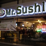
Mr. Sushi [5chw4r7z]
“We’ve had conversations with local pet shops, butcher shops, dessert companies and a variety of other businesses looking to add additional revenue and awareness to their brand,” said Sosna. “There really is no limit for what Cincybite can offer Cincinnati, and we’re working hard to expand the delivery zones so everyone in the city can enjoy.”
Those who want to use the service merely need to register for an account and then shopping as would typically be done with any online retailer. The website also allows customers to select the date and time they would like to have their items delivered, and also allows for the user to pre-select an amount to tip the driver.
But one thing that was made clear was that none of this would be possible for Sosna without the resurgence taking place in Cincinnati. Had it not been for that, he said he may have stayed in Los Angeles instead of coming home.
“The commute back and forth for 2.5 years helped calm my nerves, but as I opened my Freshii location and began spending more time in the city, I realized a lot of progress had been made and the city was headed in the right direction,” Sosna told UrbanCincy.
“The approval of the streetcar, construction of The Banks, revival of OTR, food scene throughout the city, investment in tech with Brandery and Cintrifuse, and GE selecting Cincinnati for their future operations center were just a few of the reasons highlighting how great the city had improved and made the transition all the easier.”
We have seen urban farming grow in popularity throughout Cincinnati – by far the largest urban center of the more than 3 million person mega-region – but is there an even brighter future for these community green spaces and food production zones in other smaller cities throughout the region? Might small, older cities like Hamilton and Middletown be well-suited to take the trend to the next stage? More from Urbanful:
Some two-thirds of the world’s urban land is located in small to medium urban clusters, defined as areas that are less than 10 square kilometers and up to 100 square kilometers, respectively, Shareable reports. Because more people live in small/medium urban centers, farm land in these areas can have a greater impact on the population than those of their bigger counterparts. Beyond that, less population density in smaller places means there’s a greater chance for larger land plots, which accordingly, can yields larger harvests.
A medium-sized “urban cluster” like Flint, Michigan, for instance, is just about the same size as Manhattan. According to the logic of the study, the smaller people-to-land ratio means more land would be available for urban farming in Flint. As a result, more food could be produced, and more people could reap the benefits of the production.