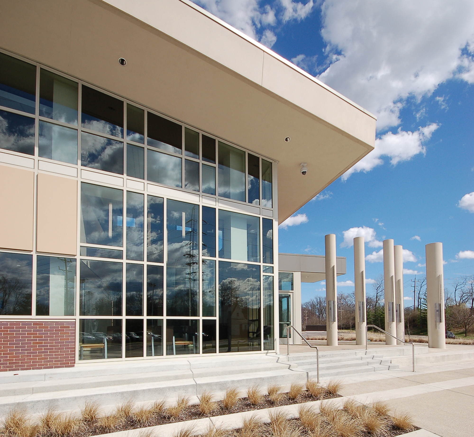
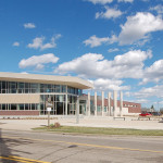
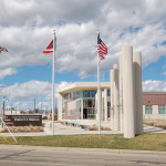
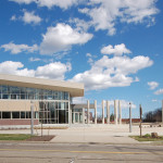
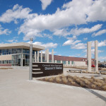
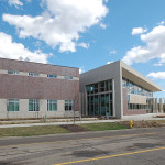
Last July the City of Cincinnati opened its first new police station in more than 20 years. Aside from updating and expanding the previous offerings inside a 107-year-old building, the new facility also aimed to create a new community gathering place for the city’s most populous neighborhood, while also achieving net-zero energy consumption.
The 36,000-square-foot facility was built for Cincinnati Police Department’s District 3, which serves 14 west side neighborhoods and some 95,000 residents. The $16 million landmark includes 40 geothermal wells, a 330-kilowatt solar panel system, and high-tech energy zones inside the building for system optimization.
Such investments have resulted in a LEED Platinum certification from the U.S. Green Building Council, the organization’s highest rating, and an energy usage coming in 20% lower than what was originally estimated for the environmentally sound building.
While the District 3 Headquarters is one of America’s most sustainable police stations, it is part of a growing trend where environmentally and economically conscience cities are looking to both reducing their carbon footprint, while also aiding their budgets through lower utility costs.
Cincinnati Police District 3 HQ
Cincinnati Police District 3 HQ
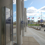
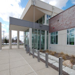
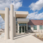
Main Entryway
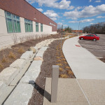
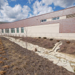
Stormwater Management System
Cincinnati Police District 3 HQ
Stormwater Management System
Bicycle Parking Outside Main Entryway
Glass Artwork
Cincinnati Police District 3 HQ
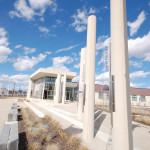
Neighborhood Landmark Poles
Main Entryway
Cincinnati Police District 3 HQ
Main Entryway
EDITORIAL NOTE: All 13 photographs were taken by Eric Anspach on March 17, 2016.
When discussing regional transportation issues, the topic seems to always be about congestion. In reality, outside of a few limited periods, the Cincinnati region has relatively good traffic flow with little actual congestion. So instead of trying to solve a problem that does not exist, we should be instead focusing our resources on maintaining our current system and improving mobility within the overall region.
As is the case in any city, the natural environment often serves as a chokepoint and barrier to regional mobility. This is true for Cincinnati with its hills and rivers.
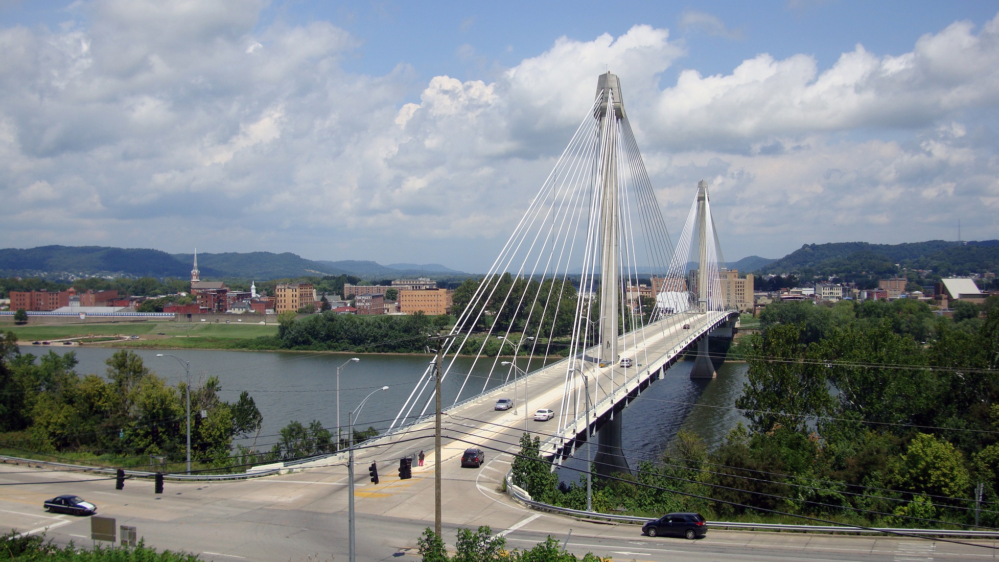
With the region’s population largely centered along the Ohio River, it is natural that this is where the most choke points exist. Outside of the center city, however, there are very few river crossings. In fact, there are only two Ohio River crossings outside of the center city, and both of those are for I-275.
One such area that makes sense for a new local road bridge is around Cincinnati’s Columbia Tusculum neighborhood and Dayton, KY near where the $400 million Manhattan Harbour project is planned.
An increasing amount of development continues to occur on the northern bank of the river in Columbia Tusculum and East End. Further up the hill sits prosperous neighborhoods like Mt. Lookout, Hyde Park, and Oakley; and just around the bend lies Lunken Airfield.
Conversely, on the south side of the river in Kentucky, large-scale development projects have long been envisioned, but are often derailed due to poor access via existing roadway networks. This remains true for Manhattan Harbour where concerns exist about the traffic burden that would be placed on the narrow KY 8 running through historic Bellevue’s quaint business district.
A local road bridge that is one lane in each direction with space for pedestrian and bicycle paths would be an ideal fit for this area of the region. It would improve mobility and access to two difficult-to-access areas. It would also offer a highway alternative for those looking to cross between the two states.
A second location where a local bridge of this nature would make sense is near where the Anderson Ferry currently operates today on the city’s west side.
The Cincinnati-Northern Kentucky International Airport sits on the southern side of the river where this bridge would land. This area continues to be bolstered by warehouses, distribution facilities and other airport-related services, and could be further bolstered with better access. What’s more, Cincinnati’s western neighborhoods that have long had to deal with excessive airplane noise, yet long treks to the airport, could at least resolve one of those injustices with a new local access bridge.
U.S. Grant Bridge [Terry Johnson]
The Taylor-Southgate Bridge is the most recent span that has been constructed over the Ohio River. It was completed in 1995 and cost $56 million at that time – approximately $85 million when adjusted for inflation. Both of these new bridges would need to span an approximate 1,700-foot-wide width, which is about 300 feet more than the Taylor-Southgate Bridge river width.
One of the main differences, however, is that the Taylor-Southgate Bridge includes two lanes of traffic in each direction, plus sidewalks. The need for only one lane of traffic on these bridges would allow them to have a deck width of around just 30 to 35 feet.
Another good nearby comparison is the U.S. Grant Bridge in Portsmouth, OH. That cable-stayed bridge was completed by the Ohio Department of Transportation in 2006 for approximately $30 million – or about $35 million in today’s dollars.
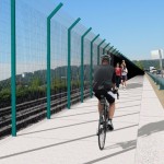
In addition to access and mobility improvements for motorists, a new bridge in both of these locations would also be a boon for cyclists. Those riding along the Little Miami Scenic Trail and the Ohio River Trail would now also be able to continue on to Northern Kentucky’s Riverfront Commons Trail, which will eventually stretch 11.5 miles from Ludlow to Ft. Thomas.
The Cincinnati region does not need multi-billion dollar solutions for a traffic congestion issues that largely do not exist. Reasonable and affordable projects that aim to increase mobility and access, along with maintaining our existing assets, should be the priority.
New local bridges connecting the region’s east and west side neighborhoods would open up land for new development, improve access between both states, enhance mobility for pedestrians and cyclists, and would do so at a price tag we can afford.
In three related moves, the City Planning Commission recommended using Interim Development Control Overlay Districts. Two were extensions of existing IDCs, but one was newly recommended. Traditionally the City uses IDCs to put a temporary control on development while planning or feasibility studies are conducted. During such time, the establishment of uses, construction of new buildings, and the demolition or alteration of existing structures are all subject to review by the City Planning Commission.
The two recommended for extension include IDC Districts 73 and 74, Wasson Line District and Pleasant Ridge NBD, for an additional six months to allow for the completion of land use and zoning studies.
Pleasant Ridge IDC [Provided]
University IDC [Provided]
University IDC [Provided]
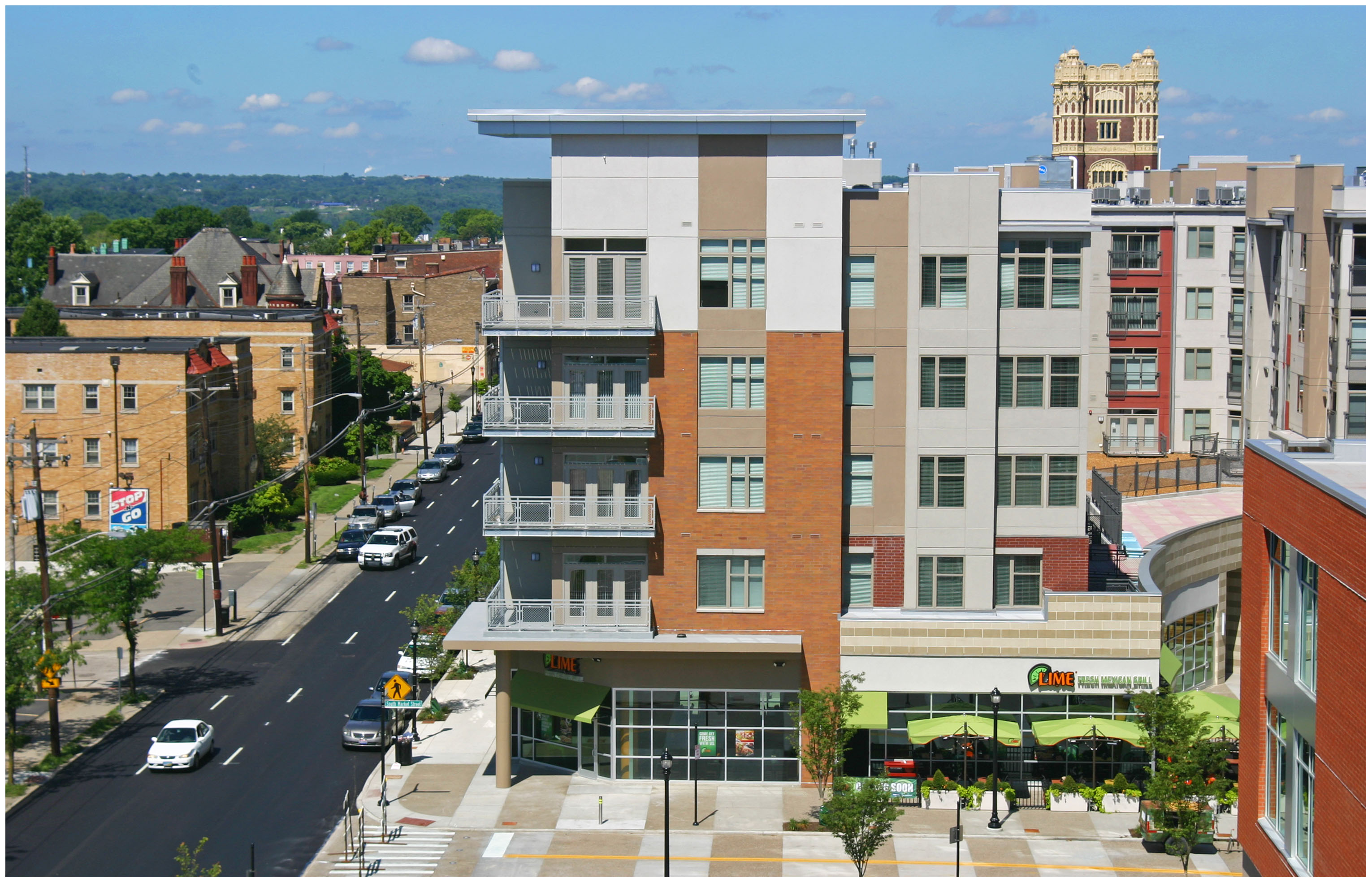
The newly recommended IDC is for the hot real estate market surrounding the University of Cincinnati. In particular, the neighborhoods to the south and southwest of the university where midrise developments continue to be proposed and built, much to the dismay of many long-time residents.
IDC District 77 was recommended to be put in place for a period of three months while a University Impact Area Study will look at growth and housing conditions, parking and traffic, quality of life concerns, and new development vs. existing character in the areas within a quarter-mile walk from the university’s main campus and the Clifton Heights business district.
Here is a quick rundown of the rest of the cases and the recommendations made by the seven-member board:
Approved the sale of 1623 Pleasant Street in Over-the-Rhine to Avila Magna Group, LLC for $20,000. The developer plans to renovate the 3,296-square-foot building into three one-bedroom for-sale units and one two-bedroom for-sale unit.
Approved the sale of approximately three acres of land left over from the Kennedy Connector road project to Vandercar Holdings and Al Neyer Inc. for $530,000. The developers plan to consolidate the land with adjacent parcels to construct two office buildings of up to 45,000 total square feet.
Approved a final development plan for Phase 1G of Oakley Station, which will consist of a 12,000-square-foot multi-tenant retail building at the northwest corner of Vandercar Way and Oakley Mill Lane.
The commission also approved the sale of a one-acre parcel at Eighth and Sycamore streets to the Cincinnati Center City Development Corporation for $1. This move will ultimately pave the way for a new $45 million development that will continue the transformation of the northeast quadrant of the central business district where numerous other midrises are advancing.
Through the agreement, the non-profit development corporation will create a garage air lot, a commercial air lot, and an apartment air lot. Once construction is imminent, 3CDC will sell the garage air lot to the City for $1 to allow for a 500-space parking garage to be built. They will then sell the apartment air lot to North American Properties for $1 for the construction of a 130-unit tower, and will retain ownership of the commercial air lot for the construction of 10,000 square feet of commercial space.
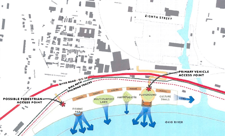
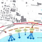
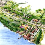
River West Working Group and Price Hill Will announced last month that they have received two grants to create a park framework plan for Price Landing, an integral piece of the overall western riverfront vision.
The first is a $30,000 grant from Interact for Health, and the second is a $16,000 grant from the Greater Cincinnati Foundation. The combination of the two will allow for the development of a vision and preliminary design for the park that would become the eastern bookend of the Ohio River Trail West.
Cincinnati’s western riverfront spans 22 miles from downtown to Shawnee Lookout, and Price Landing is seen as a critical step in reclaiming the riverfront ecosystem as a recreational and educational experience, rather than industrial.
Price Landing Vicinity [Travis Estell]
Western Riverfront Parks [Provided]
Price Landing Concept [Provided]
Glaserworks and Human Nature have been hired to create the plan for the park, which will include major park features and a preliminary budget for the construction of the project. River West Working Group will manage the design process in coordination with both firms; and they say the goal of the process is to complete the park framework plan by the middle of 2015.
“This is a very exciting addition to the many positive developments driving the ongoing revitalization of our West Side neighborhoods,” said Tom Croft, Co-Chair of River West Working Group. “With the creation of Price Landing, and the expansion and renovation of the Cincinnati Recreation’s nearby Evans Fields, Lower Price Hill will be a true recreation destination.”
Having advocated for the park since 2007, River West Working Group says their mission is to foster communication among West Side neighborhoods about development and land use issues, and to promote proactive strategies to make Cincinnati an attractive place to live and work.
In fact, the group was founded during the debate over the approval of the controversial Queensgate Terminals project. That project, which is the same site as Price Landing, would have brought a modern rail-to-barge transfer facility to the area.
In 2009 Croft said the development of Queensgate Terminals would “consign Lower Price Hill, East Price Hill, Sedamsville and Riverside to permanent blight”, and would damage perceived recovery efforts taking place at the time.
“[This site] is located at key gateways to and from West Side neighborhoods,” Croft said at the time. “In accord with the Cincinnati Scenic View Study adopted by City Council last summer, it must be protected because of its position in the line of sight from Mt. Echo and the City.”
So far the group has been quite successful. In addition to the Queensgate Terminals project being scuttled, work has also progressed on the Ohio River Trail West, and Price Landing will permanently ensure that a critical piece of riverfront property will not be developed as an industrial use.
According to Dave Zelman, co-chair of River West Working Group, the progress is something to be celebrated, saying, “With planning well underway to link Lower Price Hill to the Gilday Recreation Complex in Riverside, this park will serve as a gateway to western Hamilton County, and be a positive addition to our region.”
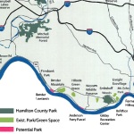
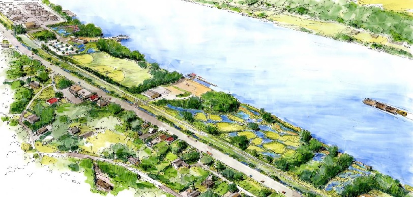
For those coming from the west side along the Ohio River, Cincinnati’s western riverfront serves as a bit of a welcome mat. However, after losing residents and jobs since mid-20th century, many in the area believe now is the time to rethink this historic area.
While oft-viewed as an industrial stretch, it is a little known fact that Cincinnati’s western riverfront is actually one of the region’s largest green corridors with riverfront parks and wooded hillsides. And just a few feet down from the busy streets and railways, there is a different Cincinnati – one community leaders believe has the potential to serve as a national example of environmental stewardship and urban recreation.
Ohio River Trail West [Provided]
Perhaps the biggest asset this area boasts is the Ohio River with its views and access to unique amenities. The existing amenities offered by the river and surrounding hillsides, combined with potential amenities from a string of riverfront parks, have the ability to create a powerful attraction for new residents and jobs. It is because of this potential that community leaders see so much value in Ohio River Trail West, which is part of the city’s larger Western Riverfront Plan.
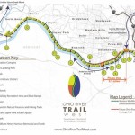
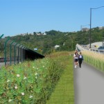
The proposed three-segment first phase of Ohio River Trail West. formerly known as the Western Riverwalk, ties together the reconstruction of the Waldvogel Viaduct, ongoing redevelopment in Lower Price Hill, and repurposing of the former Hilltop Concrete property into a park.
URS estimates that the first two segments within the first phase of work will cost approximately $1.3 million and build upon the much larger Ohio River Trail. This particular phase of trail would extend roughly 3.7 miles downriver to the Gilday Recreation Center.
Riverside Park Opportunity Area [Provided]
Anderson Ferry Opportunity Area [Provided]
The biggest of these three pieces of the puzzle is the $55 million reconstruction of the Waldvogel Viaduct. As part of the planning and engineering of the new viaduct, there will be improved views and access to the river from Lower Price Hill. Once the viaduct’s construction is complete, more than 16 acres of riverfront property will become accessible at the former Hilltop Concrete site, which had once been planned for a new rail-to-barge shipping facility, and will now become Price’s Landing.
Olyer School – an architectural treasure and a foundation of the Lower Price Hill community– recently underwent a $21 million dollar renovation; and the reconstruction of the Waldvogel Viaduct will reconnect the neighborhood to the river for the first time in over 60 years.
Meanwhile, the western end of the first phase of Ohio River Trail West is the Gilday Recreation Center, which will support the trail through its current configuration and planned upgrades.
It is estimated that the stretch of properties between the former Hilltop Concrete site and Southside Avenue are controlled by no more than five entities, and project planners have already secured roughly 70% of the right-of-way needed for this first phase of work.
Ohio River Trail West [Provided]
Phase 1, Segment 2 [Provided]
Ohio River Trail West [Provided]
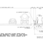
Ohio River Trail West Cross-Section [Provided]
So while ownership and access are typically major hurdles for projects of this variety, proponents are particularly excited that all of the needed right-of-way required for the first phase of work is either controlled already, or is vacant and potentially available for the new trail. Furthermore, each endpoint is owned by the City and will be able to provide both access and parking for future users.
The efforts to make this plan a reality were given a boost by former Cincinnati Mayor Mark Mallory (D) when he delivered his final State of the City Address and made the western riverfront a key component of that speech.
“If you think about the proposed investment here…this could serve as a landmark development for the west side of Cincinnati,” Mallory stated.
The efforts were then given another jolt in April 2014 when current Cincinnati Mayor John Cranley (D) allocated $250,000 to the project for ongoing engineering work, and pledged to support the project going forward.
There is currently no timetable for phase one construction activities, but project proponents hope to finalize engineering work and secure construction funding for phase one over the next year or so.