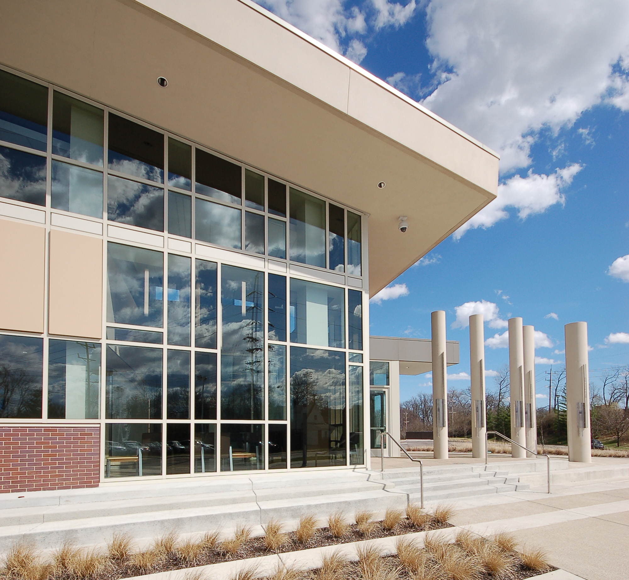
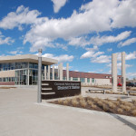
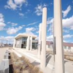
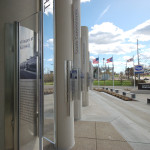
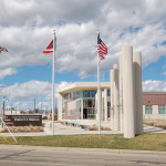
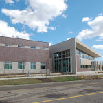
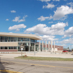
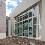
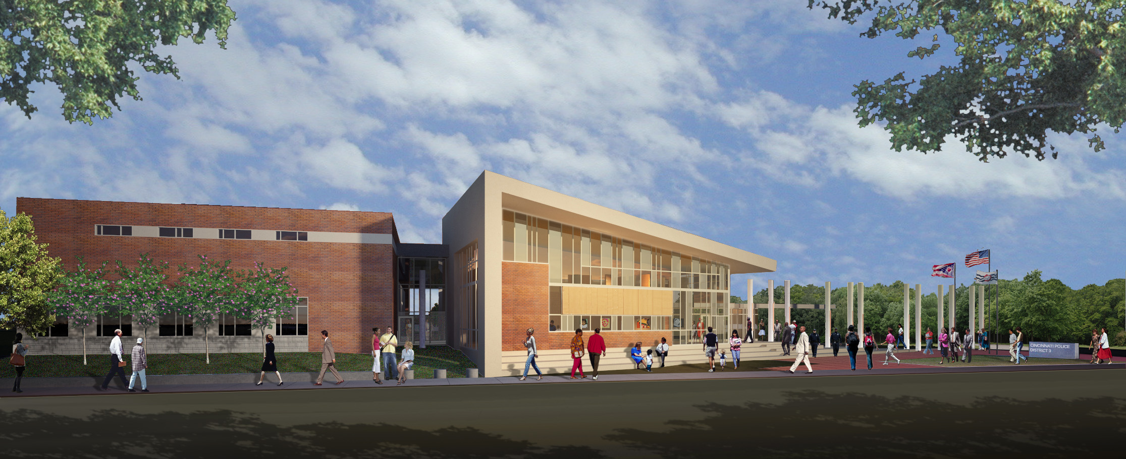
Last July the City of Cincinnati opened its first new police station in more than 20 years. Aside from updating and expanding the previous offerings inside a 107-year-old building, the new facility also aimed to create a new community gathering place for the city’s most populous neighborhood, while also achieving net-zero energy consumption.
The 36,000-square-foot facility was built for Cincinnati Police Department’s District 3, which serves 14 west side neighborhoods and some 95,000 residents. The $16 million landmark includes 40 geothermal wells, a 330-kilowatt solar panel system, and high-tech energy zones inside the building for system optimization.
Such investments have resulted in a LEED Platinum certification from the U.S. Green Building Council, the organization’s highest rating, and an energy usage coming in 20% lower than what was originally estimated for the environmentally sound building.
While the District 3 Headquarters is one of America’s most sustainable police stations, it is part of a growing trend where environmentally and economically conscience cities are looking to both reducing their carbon footprint, while also aiding their budgets through lower utility costs.
Cincinnati Police District 3 HQ
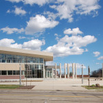
Neighborhood Landmark Poles
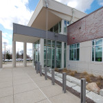
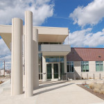
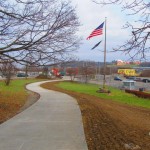
Main Entryway
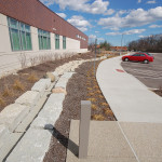
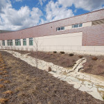
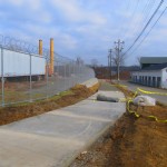
Stormwater Management System
Cincinnati Police District 3 HQ
Cincinnati Police District 3 HQ
Bicycle Parking Outside Main Entryway
Cincinnati Police District 3 HQ
Cincinnati Police District 3 HQ
Stormwater Management System
Main Entryway
Main Entryway
Glass Artwork
EDITORIAL NOTE: All 13 photographs were taken by Eric Anspach on March 17, 2016.
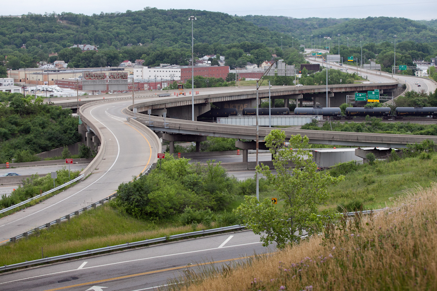
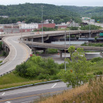
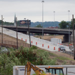
In the mid-2000s, ODOT designed a $1 billion reconstruction of I-75 between the Ohio River and I-275 that attracted little attention from the Cincinnati media. Who would win and who would lose as access points were shifted, added, or permanently closed?
Aside from a successful effort in 2006 by OKI to retain access at Galbraith Road over ODOT’s objections, virtually no public objections were made as multi-million dollar contracts were let; and work commenced in 2011 on a mega-project that will shape Cincinnati’s traffic patterns and property values for the next fifty years.
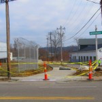
I-74 to Central Parkway Ramp [Jake Mecklenborg]
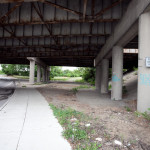
Closed Ramp at I-75 [Jake Mecklenborg]
Hopple Street Interchange [Jake Mecklenborg]
ODOT’s design strategy for the Mill Creek Expressway (Western Hills viaduct to Paddock Rd.) and Thru the Valley (Paddock Rd. to I-275) projects aimed to improve capacity and safety by reducing points of access and mitigating complex merging movements. This means most of I-75’s left-side ramps will be rebuilt as right-side ramps, and odd partial interchanges, such as the Towne Street ramps in Elmwood Place and the famous southbound “canyon” ramps in Lockland, will be permanently removed.
ODOT has already closed a lightly-used ramp providing access to I-75 southbound from Spring Grove Avenue, and another exiting I-74 westbound at Powers Street in Northside.
In 2016, ODOT plans to permanently close two ramps near Cincinnati State Technical and Community College. One provides access to I-75 northbound from Central Parkway, while the other provides access to Central Parkway from I-74. The planned closure of this final ramp – an unremarkable 250-foot deck girder overpass spanning I-75 near the Ludlow Viaduct – has been public knowledge for nearly a decade, but only recently has its closure generated opposition.
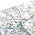
Evidence suggests that replacement of Central Parkway access from I-74 was discussed in the mid-2000s via an aerial structure approximately 10 times longer than the current 250-foot overpass. A drawing from February 2007 illustrates that the flyover ramp would have diverged from I-74 near the Colerain and Beekman Street interchange, bridged Elmore Street, then deposited traffic onto Central Parkway very close to the location of the current ramp.
2007 ODOT Plan [Provided]
Despite an effort led by Cincinnati State and then Vice Mayor Roxanne Qualls (D) several years ago, ODOT has not capitulated to recent pleas by Cincinnati State and the City of Cincinnati to reestablish the access provided by the existing 250-foot exit ramp with a similar ramp forking from the planned I-74 east to I-75 north ramp.
Such a ramp would not comply with current Federal Highway Administration guidelines, which discourage local access ramps built in close proximity to “system” interchanges, and local access ramps that diverge or join system interchange ramps. In fact, construction of a new ramp similar to what currently exists would violate Section 6.2.11 and Section 6.2 of FHWA code.
ODOT’s refusal to permit reconstruction of the I-74 ramp to Central Parkway, however, is inconsistent with its recent activities elsewhere in the state.
As part of the $200+ million reconstruction of the I-71/I-670 interchange in Columbus, an exit ramp to Leonard Avenue, a local residential street, was built in the middle of a “system” interchange. No reciprocal access to I-71 south was built, meaning this new ramp violates two sections of the FHWA’s guidelines and created a new situation identical on paper to the one ODOT seeks to eliminate in Cincinnati.
Access to Cincinnati State Community College from I-74 after 2017
In 2015, the City of Cincinnati, with the endorsement of Mayor John Cranley (D), outlined plans for an entirely new 2,500-foot viaduct connecting Elmore Street in South Cumminsville with Central Parkway at Cincinnati State. Ostensibly the proposed viaduct will restore the easy access from I-74 that Cincinnati State will lose in 2017; and, according to Cincinnati State President O’Dell Owens, help attract and retain students who commute from the city’s western suburbs.
To be sure, the proposed viaduct will improve access to I-74 westbound, as no direct access currently exists. But inbound travel will be significantly slower than what presently exists, and not much faster than what would exist if it weren’t built at all.
Perhaps the Elmore Street Viaduct, or something similar to it, could have been better integrated with the I-74 Beekman Street ramps if access to Central Parkway had been deemed a priority 10 years ago – instead ODOT completed a significant rebuilt of the interchange in 2014 with no provision for a new viaduct to Central Parkway.
Access to Cincinnati State Community College from I-75 after 2017
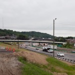
Missing from the Elmore Street Viaduct conversation, however, is the character of Cincinnati’s access from I-75. Currently, commuters from city’s northern neighborhoods must pass Cincinnati State on southbound I-75, exit at Hopple Street, then backtrack one mile north along Central Parkway. Commuters using I-75 north must exit a mile south of the college, traverse the new jug handle connection between Martin Lurther King Drive and Central Parkway, then drive one mile north.
I-75 Reconstruction [Jake Mecklenborg]
If the current circuitous path I-75 commuters use to reach Cincinnati State isn’t discouraging attendance by prospective students from those neighborhoods, why does President Owens contend that use of the very same Hopple Street exit ramp will discourage I-74 commuters?
Why No Ludlow Avenue Interchange?
Missing from I-75’s initial 1950s construction, and its current reconstruction, is a full interchange at Ludlow Avenue. A new diamond interchange on the Ludlow Viaduct would have created ideal access to Cincinnati State, a new alternative route to the University of Cincinnati and the hospitals, and significantly increased property values in Northside.
Construction of a new interchange at Ludlow Avenue does not appear to have entered into ODOT’s conversations a decade ago, nor did construction of an interchange at Vine Street in St. Bernard.
MetroMoves and the Future of the Rapid Transit Right-of-Way
In 2002, Hamilton County voters defeated MetroMoves, a half-cent sales tax that would have funded improved countywide bus service and construction of various modern streetcar and light rail lines. The initiative planned for the convergence of two light rail lines above the I-75/I-74 interchange that would have provided direct access to Cincinnati State via a station located on the west face of its hill above Central Parkway.
The convergence of two lines just north of the property promised frequent train service for the community college, even during off-peak hours; however, no call for improved public transportation has been heard from those currently pushing for the Elmore Street Viaduct.
What’s more, there has been no call to incorporate a provision for rail transit on the proposed Elmore Street Viaduct. When looking at ODOT’s 2007 drawing, it is plain to see how the proposed structure could be integrated into the light rail network, thus eliminating the high expense of a dedicated light rail viaduct over the I-75/74 interchange in the future.
Meanwhile, ODOT’s reconstruction of I-75 will leave the old Rapid Transit Loop right-of-way mostly intact between the subway portals and Cincinnati State – meaning only a 100-foot bridge over Marshall Avenue will be necessary to construct a fully grade-separated surface line between the subway portals and Cincinnati State.
EDITORIAL NOTE: After this article was published, Mayor John Cranley’s office, through spokesperson Kevin Osborne, contacted UrbanCincy and provided additional information regarding the efforts of then Vice Mayor Roxanne Qualls to piece together funding for a smaller, yet similar project years ago. This article has been updated to reflect that reality.
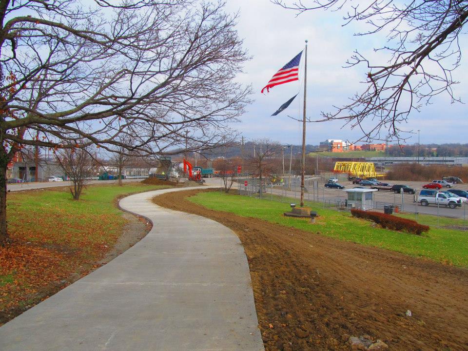
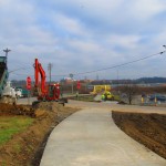
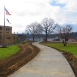
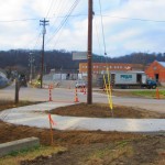
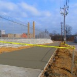
Construction is nearly complete on the fourth phase of work on the Mill Creek Greenway. As part of that work, a new 0.7-mile trail stretches along the border of South Cumminsville and Milvale, from the Millcreek Road Bridge to the intersection of Fricke Road and Beekman Street near Ethel Taylor Academy.
Once this work is complete, project planners say, the stretch will include additional accommodations for the trail to safely cross the creek on the existing roadway bridge, along with traffic calming measures for a safe crossing at Beekman Street near the school.
This latest phase of work is part of the much larger Mill Creek Greenway project that is being spearheaded by Groundwork Cincinnati – Mill Creek. The non-profit organization is celebrating its 20th anniversary this year, and is hoping that the planned 15-mile green corridor, which starts at the Hamilton County Fairgrounds in Carthage and will eventually reach the Ohio River Trail in Lower Price Hill, will help clean up one of the region’s most notoriously polluted corridors.
Phase 4 Construction [Provided]
Phase 4 Construction [Provided]
Phase 4 Construction [Provided]
Phase 4 Construction [Provided]
“We have done 33 ecological restoration projects as part of the greenway program,” Robin Corathers, Executive Director of Groundwork Cincinnati – Mill Creek, told UrbanCincy. “That includes bank stabilization, stream bed stabilization, wetland restoration, wildlife habitat restoration.”
In addition to that, Corathers says that edible forest gardens have been planted along the trail, with seven layers of vegetation that mimic a natural forest ecosystem. Improving the health of the ecosystem is a key component of Groundwork’s strategy, and more work is planned to help revitalize and heal damage to the natural resources within the Mill Creek Valley – one of the city’s oldest industrial corridors.
This latest phase of work was funded through a $245,000 grant from the Clean Ohio Trail Fund, $80,000 grant from the Interact for Health Foundation, $30,000 grant from the Greater Cincinnati Foundation, and $191,000 from the City of Cincinnati that was provided through its annual capital budget. Corathers also notes that the C.W. Wood Company donated a strip of land along Fricke Street for the trail.
The project, however, is not just about new trails and habitat restoration. Groundwork leadership also says that they are focused on capacity building, community involvement, and environmental education programming for 4,000 fourth through twelfth grade students each year.
“Phase four is really important to us for several reasons” explained Corathers. “As a ground work trust we are committed to working in economically distressed and historically under-served communities and neighborhoods; and in this case it’s the neighborhoods in the lower Mill Creek watershed.”
Millcreek Road Bridge [Google]
To this end, Corathers says that community leaders and neighborhood residents have been excited about the project and the process by which it is being implemented. She says that neighborhood councils become involved in the planning and design work of each phase of the trail, which leads to moments like this past November 12 when they celebrated the groundbreaking for the latest phase of work with about 85 area residents and business owners.
While there has been a good deal of neighborhood support, there are still challenges that exist for project leaders. One of those challenges is the Millcreek Road Bridge, which is envisioned as a crossing for the trail, but is currently only one lane in each direction for automobile traffic.
To tackle this issue, Groundwork Cincinnati has been working closely with Cincinnati’s Department of Transportation & Engineering (DOTE) to address safety issues with the narrow bridge. City officials say that the aging Mill Creek crossing is not considered a priority bridge and is not scheduled for replacement.
As a result, transportation engineers have come up with a solution that will retrofit the lightly used span to have one lane for shared two-way traffic flow, and one lane dedicated to the trail. The DOTE says that new signals will be installed, in February, at either end of the bridge to control alternating movements of vehicles across the Mill Creek Bridge.
“It’s a great investment. The bridge will be so much safer for people, for bikes, and also for vehicles,” Corathers said when emphasizing the importance of the trails connection. “The trail provides opportunities for outdoor exercise and recreation, active living, and active transportation for people in the Mill Creek corridor and nearby.”
Phase 4 Construction [Provided]
Phase 4 Construction [Provided]
Phase 4 Construction [Provided]
Phase 4 Construction [Provided]
Crossing the Mill Creek at this location is critical in the project’s overall goal of eventually reaching the Ohio River to the south. Once getting past this location, project planners say that a former CSX rail corridor can be used to take the trail all the way to its envisioned terminus.
The former freight rail right-of-way is considered to be wide enough to accommodate the Mill Creek Greenway Trail, as well as tracks for a future transit line. The use of this corridor, Corathers says, will also allow the Mill Creek Greenway Trail to tap into the planned $192 million Lick Run project, which will include another corridor of green space and trails.
Ultimately, the ongoing efforts could produce what would become a large network of interconnected trails through the heart of the city, including the Ohio River Trail, Little Miami Scenic Trail, Mill Creek Greenway, Lick Run, and West Fork Mill Creek Trail in Carthage.
The next 2.9-mile phase of work on the Mill Creek Greenway is estimated to cost $860,000, and project officials say they have already secured $500,000 of that from the State of Ohio, $50,000 from Interact for Health, and $10,000 from Duke Energy. The hope is that the remaining funds can come from City Hall. Should the final funding fall into place, Groundwork Cincinnati believes phase five work could be completed next year – creating a continuous eight-mile stretch of trails.
An attempt has been made all along to keep the trail close to the Mill Creek, but in some places, such as along Este Avenue, project planners say that it has not possible. But in locations where restoration and stabilization work has been performed along the creek, recovery of the ecosystems is easily visible.
“We now have great blue heron that fish in Mill Creek. We’ve got turtles, lizards, salamanders, beavers, birds, and all kinds of wildlife” Corathers exclaimed. “What we’re doing is breathing life back into this corridor. The trail allows users and visitors to experience an urban river that is coming back.”
In addition to Groundwork Cincinnati and the DOTE, Queen City Bike, Human Nature, IBI Group, Kolar Design, and Prus Construction have contributed to the development of the Mill Creek Greenway over the past six years.
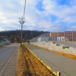
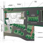
City officials and neighborhood leaders celebrated the ground breaking for Cincinnati’s new $16 million Police District 3 Headquarters on Monday.
Located in Westwood, the 39,000 square-foot facility will replace what city and police officials consider an antiquated 105-year-old facility in East Price Hill.
While the City of Cincinnati has built or begun construction on several new fire stations, including one nearby in Westwood, this is the first new police station built in the city since in more than four decades.
“It used to be that when cities built civic buildings like this, they were places the community could come together,” Mayor Mark Mallory (D) said. “With District 3, we’re doing that again. We want people to come here and feel comfortable coming here with their neighbors.”
According to city officials, the new police headquarters will serve 14 neighborhoods from a central location on the west side. A site that was specifically chosen due to the input provided during Plan Cincinnati.
To help further strengthen the concept of the police headquarters also serving as a community gathering place, city officials have ensured that the new facility will include community gathering space and public art. It is an approach to community building similar to what was done, with rave reviews, by Cincinnati Public Schools (CPS) when rebuilding its entire building portfolio.
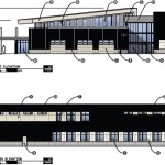
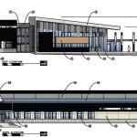
The location is just a block away from Dater High School and Western Hills High School and sits in what was a vacant outlot of a suburban-style strip mall. Site plans show that the new facility will be built at the street and oriented toward the sidewalk.
While Cincinnati has been seen as a leader in green building when it comes to the rebuilding of CPS, its tax abatements for Leadership in Energy and Environmental Design (LEED) rehabilitation and new construction, and public building in general, this will be one of the Queen City’s greenest buildings.
The development team also says that it has designed the structure to achieve Net Zero Energy Consumption through its geothermal mechanical systems, high performance building envelope and solar panels. The new Police District 3 Headquarters will also reduce potable water consumption by 30% thanks to on-site bio-retention cells and strategic use of site design materials.
City leadership also expects the project will reach 36.2% Small Business Enterprise (SBE) inclusion. If such a number is achieved, it would make it the highest percentage of SBE participation on any city project to-date.
According to project officials, construction is expected to take about a year-and-a-half and could start welcoming members of the community as early as July 2015.
The Secretary of Housing and Urban Development (HUD), Shaun Donovan, is in Cincinnati today to celebrate the completion of the newly redeveloped housing project called the Villages at Roll Hill. The project, which was once known as Fay Apartments, is being heralded as the largest green renovation, affordable housing project in the country.
Redevelopment of the long-stalled neighborhood had begun in earnest in 2010 after years of setbacks and delays. As disclosed by UrbanCincy in 2010, developers were able to tap a variety of funding sources to get the project off the ground including a $32 million loan from HUD and a $3.2 grant from City HOME. The City of Cincinnati also granted an eight-year tax abatement on the renovated units.
The rehabilitation included the demolition of 17 buildings on site and reduced the number of housing units to 703. The upgrades also include landscaping, security, tree installation, a new playground and other improvements.
The Villages of Roll Hill is located along Baltimore Avenue on the west side of Cincinnati. The housing development debuted in 1962 as a promising new city neighborhood with over 1,025 market rate apartments. The development was owned and operated by HUD but was bought by the City in 1982.
By 1986, the City sold the struggling development to Stern-Hendy due to promises to invest millions in rehabilitating and repairing the complex. By 2005, however, there were only 112 market rate apartments left, 650 were rented to Housing Choice Voucher recipients (Section 8) and 128 were rehabilitative housing operated by Cincinnati Metropolitan Housing Authority (CMHA).