When discussing regional transportation issues, the topic seems to always be about congestion. In reality, outside of a few limited periods, the Cincinnati region has relatively good traffic flow with little actual congestion. So instead of trying to solve a problem that does not exist, we should be instead focusing our resources on maintaining our current system and improving mobility within the overall region.
As is the case in any city, the natural environment often serves as a chokepoint and barrier to regional mobility. This is true for Cincinnati with its hills and rivers.
With the region’s population largely centered along the Ohio River, it is natural that this is where the most choke points exist. Outside of the center city, however, there are very few river crossings. In fact, there are only two Ohio River crossings outside of the center city, and both of those are for I-275.
One such area that makes sense for a new local road bridge is around Cincinnati’s Columbia Tusculum neighborhood and Dayton, KY near where the $400 million Manhattan Harbour project is planned.
An increasing amount of development continues to occur on the northern bank of the river in Columbia Tusculum and East End. Further up the hill sits prosperous neighborhoods like Mt. Lookout, Hyde Park, and Oakley; and just around the bend lies Lunken Airfield.
Conversely, on the south side of the river in Kentucky, large-scale development projects have long been envisioned, but are often derailed due to poor access via existing roadway networks. This remains true for Manhattan Harbour where concerns exist about the traffic burden that would be placed on the narrow KY 8 running through historic Bellevue’s quaint business district.
A local road bridge that is one lane in each direction with space for pedestrian and bicycle paths would be an ideal fit for this area of the region. It would improve mobility and access to two difficult-to-access areas. It would also offer a highway alternative for those looking to cross between the two states.
A second location where a local bridge of this nature would make sense is near where the Anderson Ferry currently operates today on the city’s west side.
The Cincinnati-Northern Kentucky International Airport sits on the southern side of the river where this bridge would land. This area continues to be bolstered by warehouses, distribution facilities and other airport-related services, and could be further bolstered with better access. What’s more, Cincinnati’s western neighborhoods that have long had to deal with excessive airplane noise, yet long treks to the airport, could at least resolve one of those injustices with a new local access bridge.
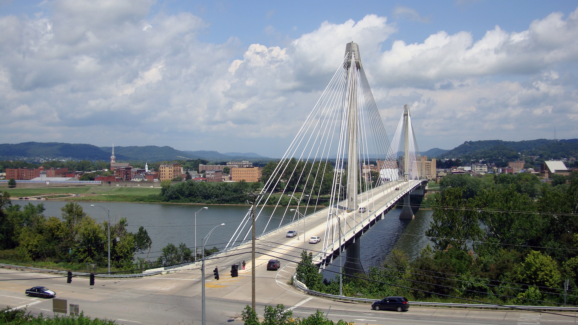
U.S. Grant Bridge [Terry Johnson]
The Taylor-Southgate Bridge is the most recent span that has been constructed over the Ohio River. It was completed in 1995 and cost $56 million at that time – approximately $85 million when adjusted for inflation. Both of these new bridges would need to span an approximate 1,700-foot-wide width, which is about 300 feet more than the Taylor-Southgate Bridge river width.
One of the main differences, however, is that the Taylor-Southgate Bridge includes two lanes of traffic in each direction, plus sidewalks. The need for only one lane of traffic on these bridges would allow them to have a deck width of around just 30 to 35 feet.
Another good nearby comparison is the U.S. Grant Bridge in Portsmouth, OH. That cable-stayed bridge was completed by the Ohio Department of Transportation in 2006 for approximately $30 million – or about $35 million in today’s dollars.
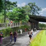
In addition to access and mobility improvements for motorists, a new bridge in both of these locations would also be a boon for cyclists. Those riding along the Little Miami Scenic Trail and the Ohio River Trail would now also be able to continue on to Northern Kentucky’s Riverfront Commons Trail, which will eventually stretch 11.5 miles from Ludlow to Ft. Thomas.
The Cincinnati region does not need multi-billion dollar solutions for a traffic congestion issues that largely do not exist. Reasonable and affordable projects that aim to increase mobility and access, along with maintaining our existing assets, should be the priority.
New local bridges connecting the region’s east and west side neighborhoods would open up land for new development, improve access between both states, enhance mobility for pedestrians and cyclists, and would do so at a price tag we can afford.
Overpass at North Highland Avenue [Atlanta BeltLine]
Following the guidance of City Council, Cincinnati’s Department of City Planning & Buildings has completed its land use study for the Wasson Railroad Corridor. The study’s findings and recommendations offer the clearest guidance to-date as to how to proceed with redeveloping the abandoned freight rail corridor, following the issuance of preliminary designs in July 2014.
City planners took a comprehensive look at the history of the corridor, its current conditions and the best path forward that respects the desires of the city and the impacted neighborhoods.
In that analysis City staff revealed seven studies and plans that recommend the corridor either be used for rail transit, or a combined multi-modal network that accommodates rail transit, bicycles and pedestrians. Some of the most notable of these include the 2002 MetroMoves regional transit plan, 2010 Bicycle Transportation Plan, 2012 comprehensive Plan Cincinnati, and the 2013 Railroad Safety Improvement Plan – all of which either specifically call for the corridor to be used for rail transit, or a multi-modal corridor.
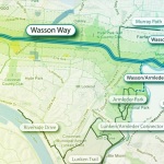
Wasson Way Trail [Provided]
The history is important as it influenced the study’s recommendation as to how to proceed with acquiring and preserving the corridor. As of now, the 5.7-mile Wasson Railroad Corridor is still owned by Norfolk Southern, but the City of Cincinnati has stated that they are in the process of acquiring the property from them.
“With this corridor being so crucial to the future development of multi-modal transportation in the City, the threat of potential development within the railroad right-of-way would significantly slow down, if not completely hinder, those possible public transportation opportunities from occurring,” city planners wrote in the 32-page land use study released earlier this month.
Of course, this fact has been known by policy makers at City Hall for years. As a result, City Council has, on several occasions, approved interim development controls to protect the corridor from being built upon. These controls, however, are just temporary and city officials must now decide how they would like to move forward.
In the study city planners examined the pros and cons of three potential options for accomplishing this.
The first option examined the idea of rezoning the property to a Parks and Recreation classification. This would offer the corridor significant protections, but it would also severely restrict the City from being able to implement rail transit in the future due to federal regulations that prohibit the use of public parks or wildlife refuges for transit corridors.
A second option studied looked at simply dedicating the land as City right-of-way. This too would offer significant protections, but is not possible until the City acquires the land from Norfolk Southern.
The third option, and the one recommended by city staff, is enacting a Transportation Overlay District over the corridor. While planners admit that crafting the language for such legislation may be complicated, they also stated that it would be most aligned with the preferences of neighborhood residents and publicly adopted planning documents.
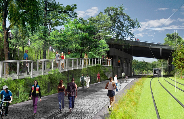
In order to address the complexity of the legislation required for such an overlay district, city planners recommended looking at the Atlanta BeltLine Overlay District that was implemented to protect a 22-mile abandoned freight rail corridor. In Atlanta civic leaders are currently in the process of converting the corridor into a similarly envisioned multi-modal network with rail transit, bikeways, parks and pedestrian paths.
The Square at Ford Factory Lofts [Atlanta BeltLine]
Overpass at North Highland Avenue [Atlanta BeltLine]
Irwin Promenade [Atlanta BeltLine]
“While all options present advantages and disadvantages, the Transportation Overlay District is seen as the best solution for preservation of the Wasson Railroad Corridor,” city planners wrote. “This tool, while it may take a bit longer to craft the ordinance language, will provide more flexibility and also protect the contiguous nature of the corridor.”
City officials say that this solution will allow for the development of the Wasson Way Trail to move forward in the near term, while affirming the City’s intentions to develop the corridor as a multi-modal transportation facility that includes rail transit in the future.
The solution crafted by the Department of City Planning & Buildings appears to be a perfect compromise between the two constituencies looking to use the corridor. Bicycle advocacy groups can see the right-of-way acquired and preserved so that they can move forward with their plans for a bike and pedestrian trail, while transit advocates can rest assure that those immediate efforts are not being done in conflict with ongoing planning and design work for a future light rail line.
With the Wasson Railroad Corridor Land Use Study now complete, it will go before the city’s Planning Commission. Should it be approved by Planning Commission, it will then go back to city staffers so that draft overlay district language can be crafted and recommended to City Council. From there, it would go before City Council for approval.
It is a standard process and one that advocates hope can be completed in the coming months.
Project and community leaders are excited about the work because it will fill in a gap in the Ohio River Trail that will eventually stretch 23 miles from Coney Island on the east to Sayler Park on the west. The project will also represent an approximate 50% increase in the number of completed miles of the Ohio River Trail.
While designs are still being finalized, city officials presented a conceptual design and the preferred alignment with the public at an open house held on March 25.
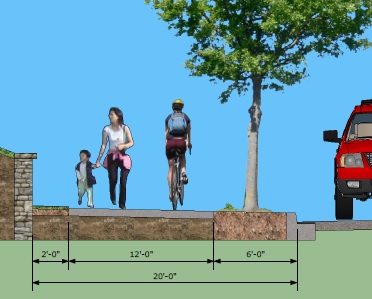
The designs call for a shared use, asphalt path for bicyclists and pedestrians that is 12 feet wide. There would be a six-foot setback from the road, and the path would essentially function as an extra wide sidewalk in order to avoid taking any right-of-way away from automobiles.
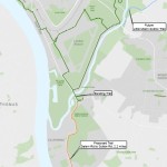
The preferred alignment for the shared trail would run along the eastern side of Kellogg Avenue and go through the California Woods Nature Preserve. The pathway would pass underneath I-275 at the foot of the Combs-Hehl Bridge.
Project officials say that they will take feedback given during the recent open house into consideration when developing final designs, and formulate construction cost estimates. The next public meeting will take place in October.
If all goes according to plan, detailed design work will be complete by October 2016 and construction will begin in June 2017.
Tomorrow at 12pm, City Council’s Strategic Growth Committee will discuss the proposal that would turn the Wasson Corridor from a railroad right-of-way into a recreational trail. What UrbanCincy is urging City Council to require is a minimum of 28 feet worth of right-of-way preserved for future light rail use.
Standard designs for bi-directional light rail traffic require a minimum of 28 feet of right-of-way. Along some portions of the Wasson Corridor it may very well be possible to accommodate 28 feet for light rail, plus additional right-of-way for the proposed recreational trail, and in those segments it may make sense to get started.
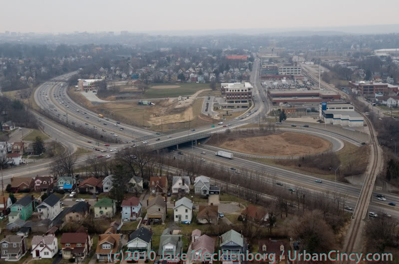
Looking east as the Wasson Line crosses over Interstate 71. Photograph by Jake Mecklenborg for UrbanCincy.
While there is no funding currently in place to build light rail along the Wasson Corridor, it would be short-sighted to remove one of the best rail transit corridors in the city. This was previously done on Cincinnati’s west side when an abandoned railway used by freight and passenger rail traffic was abandoned and then allowed to be built over and occupied by the Glenway Crossings retail center.
Allowing this to take place offered city and county leaders to reap the rewards of a short-term boost, but it has also created a situation that makes building light rail to Cincinnati’s western suburbs almost impossible. This same thing could happen to Cincinnati’s eastern suburbs should the Wasson Corridor be used by a recreational trail.
Proponents of the Wasson Way Trail project made it clear that many of the supporters also want to see light rail eventually happen, but that we should not wait until that day comes to improve the visual appearance of the corridor. Case studies from all over the United States show, however, that once a former rail line is converted into another use, it is almost always an impossible political task to take that land back for rail purposes.
2002 regional light rail plan for Cincinnati.
In the larger scheme of things, UrbanCincy believes that regional leaders need to take a step back and ask themselves why we are still discussing commuter rail along the Ohio River, and a recreational trail through densely populated city neighborhoods. The priorities should be reversed, and the Oasis Line along the Ohio River should be converted into a recreational trail while the Wasson Line is preserved for future light rail use.
It is estimated that the Wasson Light Rail Line would attract three times the number of riders than the Oasis Commuter Rail Line, while also being significantly less expensive to build and operate. Futhermore, when discussions were held about the Oasis Line, residents and property owners along the line voiced their opposition to such activity and have conversely expressed interest in seeing the railway converted into a recreational trail.
City and regional leaders should maintain the natural beauty of the Ohio River and turn the Oasis Line into an attractive recreational trail that can connect into existing trail networks to the east, and the Wasson Line should be preserved for light rail use in the future. It may seem frustrating to leave the Wasson Line in its current state of appearance, but it will be much more frustrating to jeopardize one of the best potential light rail corridors envisioned for the region.
The Eastern Corridor project, a multi-modal highway and commuter rail plan for eastern Hamilton County, is back in the news. Two weeks ago Cincinnati City Council voted against endorsing a TIGER II grant application seeking funds for the plan’s 17-mile commuter rail component.
The local media predictably turned this event into another city-county dispute, and insinuated that the TIGER II grant might alone fund construction of the entire Milford commuter rail line, which in 2003 was estimated to cost $420 million. There is no possibility of this happening, as Milford commuter rail would need to be awarded approximately two-thirds of the entire $600 million sum to be dispersed nationwide by the TIGER II program.
The media also ignored the Eastern Corridor plan’s central feature – four miles of the Milford commuter rail line is planned to be built parallel to a new $500 million U.S. 32 expressway between Red Bank Road and a point east of Newtown. The 1990’s cost estimate for Milford commuter rail included the savings associated with building a combined highway and rail project, including a new shared eight-lane bridge over the Little Miami River. The cost of building the commuter line first without provision for the future highway has not been studied.
The Oasis Line
Between downtown Cincinnati and the proposed eight-lane bridge over the Little Miami River, the Milford commuter rail is planned to operate on an eight-mile stretch of track paralleling the Ohio River known as the “Oasis Line.” In the late 1980’s the L&N Bridge (now the Purple People Bridge) was closed to freight rail traffic, and thus ended the operation of large trains along the Oasis Line. Since that time, traffic has been limited to a handful of freight cars per week, and the Cincinnati Dinner Train on weekends.
At first glance it would appear that implementation of commuter rail service on the Oasis Line should require nothing more than the purchase of commuter trains and the construction of a connection between the end of active tracks and the Riverfront Transit Center. Unfortunately, the poor condition of the existing track limits traffic to a maximum twelve miles per hour, meaning all eight miles between the Montgomery Inn Boathouse and Red Bank Road must be rebuilt. It is also probable that the Riverfront Transit Center connection must be built at least partially through Bicentennial Commons at Sawyer Point. All of this new track must be heavy freight railroad track, not the smaller and less expensive track used by light rail trains and modern streetcars.
Even after this needed investment in new track, grade crossings will remain at a half-dozen locations along Riverside Drive and in Columbia Tusculum, where perfunctory horn blasts will disturb those residing in new condos along Riverside Drive, longtime residents atop Mt. Adams and East Walnut Hills, and will surely be audible across the river in Bellevue and Dayton.
Poor Station Locations
Residents of Riverside Drive will be able to hear the Milford commuter rail trains, but most will not live within easy walking distance of the line’s stations. Of five stations proposed along the Oasis Line, only one, Delta Avenue in historic Columbia Tusculum, can be considered auspicious. By contrast, little existing ridership or future development exists around either the proposed Theodore Berry Park or the Cincinnati Waterworks (downhill from Torrence Parkway) stations. Ridership at the proposed Lunken Airport station will be minimal, and the Beechmont Avenue station will primarily serve as a bus transfer point.
On top of this minimal ridership, Riverside Drive is already served by Metro’s #28 bus. If Milford commuter rail is built, this bus will still have to operate due to the infrequent service and long distances between stations along the Oasis Line. It is also likely that Metro’s #28X, which serves Mariemont and Terrace Park en route to Milford, will have to continue operations as well.
An alternative proposal that called for streetcar or light rail service between downtown and Lunken Airport could eliminate the need for the #28 bus route, thus freeing up resources for bus service elsewhere. In this scenario significant savings would be achieved due to the considerably lower track costs for streetcars and light rail when compared to the freight railroad track currently proposed for the Milford commuter rail. Additionally, the vehicles are much quieter because they are electrically powered, labor costs are halved because they require just one driver, and more stops could be placed at much closer intervals.
High Operations Costs
No funding source has been identified to cover the outrageous annual operating costs for Milford commuter rail. In 2004 its annual operations were estimated to be $18.9 million — a sum similar to the estimated annual operating cost of the proposed 250-mile 3C Corridor passenger rail service between Cincinnati, Columbus, and Cleveland.
The cause of these exorbitant operating costs is an alarming combination of mediocre ridership and high labor costs. A 2002 report projected approximately 6,000 weekday trips (3,000 commuters) along the Oasis Line at full build-out. For comparison, this ridership figure is roughly equivalent to Metro’s most popular bus routes. At the same time, the FTA requires a crew of two onboard all diesel commuter trains that operate on freight tracks, even for the small Diesel Multiple Units (DMUs) planned for the Eastern Corridor, due to safety regulations.
By comparison, the Cincinnati Streetcar as presently planned will cost approximately $128 million to construct, require $3 million per year to operate, and will attract similar or higher daily ridership with 15 fewer route miles of track. Last month, city officials were notified that the Cincinnati Streetcar was awarded a $25 million Urban Circulator grant. If an identical amount were hypothetically awarded to the Eastern Corridor project through TIGER II, it would cover so little of the much more expensive Milford commuter rail that no construction would even be able to take place. Meanwhile, an additional $25 million put towards the Cincinnati Streetcar could extend the line into Avondale or Walnut Hills immediately. This means a potential grant for the Milford commuter rail might sit in the county treasury for a decade or more, or through tricky accounting be integrated into the Eastern Corridor project’s highway funding.
The Wasson Line
An alternative rail route to eastern Hamilton County involves use of the Wasson Line, which joins the Oasis Line near Red Bank Road but travels a very different path between that point and downtown Cincinnati. This route is eight miles – the exact same distance as the Oasis Line – but promises much higher ridership and much lower operational costs.
Since all freight operations ceased on the Wasson Line in 2009, electric light rail vehicles staffed by a single driver can be used at considerable cost savings over diesel commuter trains needed on the Oasis Line. Proposed station locations at Xavier University, Montgomery Road, Edwards Road, and Paxton Avenue each promise higher initial ridership — in 2002 the Wasson Line was estimated to attract 20,000 daily riders, or triple that of Milford commuter rail.
Also different from the Oasis Line, redevelopment potential exists around all of the stations locations along the Wasson Line, but especially the 25-acre parallelogram-shaped parcel recently assembled by Xavier University between its campus and Montgomery Road. The abandoned Wasson Road Railroad bisects this property and converges with the similarly abandoned CL&N railroad at the present edge of Xavier’s campus. The particular junction played a major role in the 2002 MetroMoves regional rail plan due to the convergence of several regional lines on their way into downtown along shared Gilbert Avenue tracks.
The Edward Road station is another location superior to anything on the Oasis Line. It is located within walking distance of Hyde Park Square and the majority of the neighborhood’s population. The station would be placed adjacent to, or across the street from, Rookwood Commons shopping center, and just a three-minute walk from the undeveloped Rookwood Exchange site north of Edmondson Road.
The Wasson Line has decisive cost-benefit advantages over the Oasis Line, but it obviously cannot function without a connection between Xavier University and downtown. After completion of the Cincinnati Streetcar, construction of a light rail connection between these points should be a top priority. This section alone promises the highest per-mile transit ridership in the metro area, and reaching Xavier University allows construction of three light rail branches, on existing railroad right-of-way, as funds permit.
Regional Priorities
It is unclear why construction of the Eastern Corridor project is any kind of priority. Much of the expense will be borne by Hamilton County, but with parts of the highway and rail line traveling over the undevelopable Little Miami River flood plain, the new expressway and perhaps even the rail line will act to encourage sprawl in Clermont County. Even the terminal station for the Milford commuter rail will not be in Milford’s town center, where it would be within walking distance of several hundred residents, but rather two miles away at Milford Parkway, home to Wal-Mart, Target, and chain sports bars.
Anti-rail forces are fond of saying that rail advocates will support anything that runs on rails. But advocates of better public transportation know that funds for rail projects are scarce and must be applied where the best cost-benefit exists. Moreover, the best transit mode must be chosen for each route. In the case of inner-city rail to Cincinnati’s eastern suburbs, diesel commuter rail along the Oasis Line is not the best solution, but rather, light rail service along the Wasson Line is.