Changes are afoot for Cincinnati residents — underfoot, that is.
The Metropolitan Sewer District (MSD) recently unveiled sweeping changes to the region’s sewage system. By optimizing the existing infrastructure’s ability to handle wet weather, newly-installed smart technologies will reduce environmental risk, slash rates, and prolong its life.
“Our smart sewer system is anticipated to save tens of millions of dollars in capital investments in projects to control sewer overflows,” said MSD Director Gerald Checco in the press release. “This is our best chance of reducing spending and ultimately costs for our ratepayers.”
Prior to this announcement, MSD’s reputation had been marred by a string of scandals. Investigations into their financial practices exposed several improprieties and a once-in-a-century storm flooded homes across the county with backed-up sewage.
Illustration of a CSO (City of Cincinnati)
Yet, amid the hoopla, the Mill Creek basin was reaping the benefits of a smart sewer system. A centralized “brain” tracked flow rates throughout the system. New sensors and gates diverted excess storm runoff into larger pipes or other areas that weren’t full. “The ability to have a view of our entire system in real time really helps us to respond quicker to things because it raises that awareness,” said Missy Gatterdam, head of MSD’s watershed operations division, in an interview with UrbanCincy.
Outside this basin, MSD’s pipes empty into nearby streams or rivers, a process called a Combined Sewer Overflow (CSO). CSOs are legal, but they can damage the environment. Sewers combine domestic, commercial, and industrial runoff with storm runoff. On dry days, this is not a problem. Toxic wastes migrate to a treatment facility.
On particularly rainy days, however, the pipes can’t handle all of the waste and water and must dump these undesirables into the ecosystem. (Here is a video MSD made to help explain the process.)
Untreated water isn’t just disgusting; it’s also deadly. An Environmental Protection Agency report to Congress in 2001 says bacteria found in untreated waters can cause gastric disorders, typhoid, and even cholera. Thankfully, MSD’s smart system will reduces the 11.5 billion gallons of runoff and waste overflow that wind up in the region’s waterways every year.
Gatterdam remarked that the original plan was to rollout the technology to the Muddy Creek and the Little Miami River basins this year, but budget cuts by the county have halted any expansion.
The purpose of the report, the Sierra Club states, is to bring light the more than $200 billion worth of transportation projects that advance each year, and identify which of those meet higher national goals of “reducing oil consumption, increasing safety, improving public health, and saving local, state or federal government – and citizens – money.”
The State of Ohio had only two projects that made it into the Sierra Club’s 2012 report, and both were from the Cincinnati region.
The first was the Eastern Corridor project which was identified as one of the nation’s worst projects, with the report stating:
The Eastern Corridor Highway in Cincinnati, Ohio was first proposed in 1999 when the price of gas was $1.14. The project is currently under study, with plans to convert a road into a 10-mile, four- to six-lane expressway. The Highway poses a significant threat to the scenic Little Miami River. The route parallels the river and plans to cross it in an ecologically threatened area, where numerous rare, threatened and endangered species live. Furthermore, the highway will slice the historic village of Newton in half, which would disrupt the community and its tax base, adding traffic and pollution. The village’s mayor has been an outspoken critic of the project. The highway project is expected to cost upwards of a billion dollars.
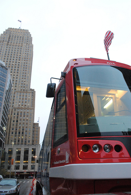
The second area project that made it onto the environmental organization’s list is the Cincinnati Streetcar, which they called one of America’s best transportation projects.
The Cincinnati Streetcar is a new electric streetcar project that will connect key communities in the city’s urban core while improving neighborhood accessibility, stimulating development, and creating jobs. The streetcar system will go from the River to the Zoo, University, and hospital area. There are currently more than 500 vacant buildings along the streetcar’s 4-mile route. The streetcar will help attract residents and businesses to these rehabbed buildings, putting people to work and boosting the city’s tax revenue. Streetcars will increase accessibility and active transportation in the region by creating denser, more walkable, mixed use development. The streetcars are designed to accommodate both wheelchairs and bicycles and will serve as a complement to the city’s existing bus transit. Construction began in February 2012 and the streetcar is expected to open in 2014.
The full report identifies a wide range of projects including highways, bridges, mass transit, active transportation, aviation, aquatic, and multi-modal investments. Projects of all varieties made it onto both the good and bad lists, but the Sierra Club largely favored transit and active transportation projects over highways and bridges.
“Americans are struggling with the health, climate, and economic costs of our oil-centered transportation system,” the report states. “Our transportation investments should provide an opportunity to further reduce our dependence on oil, reverse climate disruption, and save money. Because transportation infrastructure lasts for decades, the impacts of transportation investments are felt for many years to come, with huge consequences for America’s ability to move beyond oil.”
The Eastern Corridor project, a multi-modal highway and commuter rail plan for eastern Hamilton County, is back in the news. Two weeks ago Cincinnati City Council voted against endorsing a TIGER II grant application seeking funds for the plan’s 17-mile commuter rail component.
The local media predictably turned this event into another city-county dispute, and insinuated that the TIGER II grant might alone fund construction of the entire Milford commuter rail line, which in 2003 was estimated to cost $420 million. There is no possibility of this happening, as Milford commuter rail would need to be awarded approximately two-thirds of the entire $600 million sum to be dispersed nationwide by the TIGER II program.
The media also ignored the Eastern Corridor plan’s central feature – four miles of the Milford commuter rail line is planned to be built parallel to a new $500 million U.S. 32 expressway between Red Bank Road and a point east of Newtown. The 1990’s cost estimate for Milford commuter rail included the savings associated with building a combined highway and rail project, including a new shared eight-lane bridge over the Little Miami River. The cost of building the commuter line first without provision for the future highway has not been studied.
The Oasis Line
Between downtown Cincinnati and the proposed eight-lane bridge over the Little Miami River, the Milford commuter rail is planned to operate on an eight-mile stretch of track paralleling the Ohio River known as the “Oasis Line.” In the late 1980’s the L&N Bridge (now the Purple People Bridge) was closed to freight rail traffic, and thus ended the operation of large trains along the Oasis Line. Since that time, traffic has been limited to a handful of freight cars per week, and the Cincinnati Dinner Train on weekends.
At first glance it would appear that implementation of commuter rail service on the Oasis Line should require nothing more than the purchase of commuter trains and the construction of a connection between the end of active tracks and the Riverfront Transit Center. Unfortunately, the poor condition of the existing track limits traffic to a maximum twelve miles per hour, meaning all eight miles between the Montgomery Inn Boathouse and Red Bank Road must be rebuilt. It is also probable that the Riverfront Transit Center connection must be built at least partially through Bicentennial Commons at Sawyer Point. All of this new track must be heavy freight railroad track, not the smaller and less expensive track used by light rail trains and modern streetcars.
Even after this needed investment in new track, grade crossings will remain at a half-dozen locations along Riverside Drive and in Columbia Tusculum, where perfunctory horn blasts will disturb those residing in new condos along Riverside Drive, longtime residents atop Mt. Adams and East Walnut Hills, and will surely be audible across the river in Bellevue and Dayton.
Poor Station Locations
Residents of Riverside Drive will be able to hear the Milford commuter rail trains, but most will not live within easy walking distance of the line’s stations. Of five stations proposed along the Oasis Line, only one, Delta Avenue in historic Columbia Tusculum, can be considered auspicious. By contrast, little existing ridership or future development exists around either the proposed Theodore Berry Park or the Cincinnati Waterworks (downhill from Torrence Parkway) stations. Ridership at the proposed Lunken Airport station will be minimal, and the Beechmont Avenue station will primarily serve as a bus transfer point.
On top of this minimal ridership, Riverside Drive is already served by Metro’s #28 bus. If Milford commuter rail is built, this bus will still have to operate due to the infrequent service and long distances between stations along the Oasis Line. It is also likely that Metro’s #28X, which serves Mariemont and Terrace Park en route to Milford, will have to continue operations as well.
An alternative proposal that called for streetcar or light rail service between downtown and Lunken Airport could eliminate the need for the #28 bus route, thus freeing up resources for bus service elsewhere. In this scenario significant savings would be achieved due to the considerably lower track costs for streetcars and light rail when compared to the freight railroad track currently proposed for the Milford commuter rail. Additionally, the vehicles are much quieter because they are electrically powered, labor costs are halved because they require just one driver, and more stops could be placed at much closer intervals.
High Operations Costs
No funding source has been identified to cover the outrageous annual operating costs for Milford commuter rail. In 2004 its annual operations were estimated to be $18.9 million — a sum similar to the estimated annual operating cost of the proposed 250-mile 3C Corridor passenger rail service between Cincinnati, Columbus, and Cleveland.
The cause of these exorbitant operating costs is an alarming combination of mediocre ridership and high labor costs. A 2002 report projected approximately 6,000 weekday trips (3,000 commuters) along the Oasis Line at full build-out. For comparison, this ridership figure is roughly equivalent to Metro’s most popular bus routes. At the same time, the FTA requires a crew of two onboard all diesel commuter trains that operate on freight tracks, even for the small Diesel Multiple Units (DMUs) planned for the Eastern Corridor, due to safety regulations.
By comparison, the Cincinnati Streetcar as presently planned will cost approximately $128 million to construct, require $3 million per year to operate, and will attract similar or higher daily ridership with 15 fewer route miles of track. Last month, city officials were notified that the Cincinnati Streetcar was awarded a $25 million Urban Circulator grant. If an identical amount were hypothetically awarded to the Eastern Corridor project through TIGER II, it would cover so little of the much more expensive Milford commuter rail that no construction would even be able to take place. Meanwhile, an additional $25 million put towards the Cincinnati Streetcar could extend the line into Avondale or Walnut Hills immediately. This means a potential grant for the Milford commuter rail might sit in the county treasury for a decade or more, or through tricky accounting be integrated into the Eastern Corridor project’s highway funding.
The Wasson Line
An alternative rail route to eastern Hamilton County involves use of the Wasson Line, which joins the Oasis Line near Red Bank Road but travels a very different path between that point and downtown Cincinnati. This route is eight miles – the exact same distance as the Oasis Line – but promises much higher ridership and much lower operational costs.
Since all freight operations ceased on the Wasson Line in 2009, electric light rail vehicles staffed by a single driver can be used at considerable cost savings over diesel commuter trains needed on the Oasis Line. Proposed station locations at Xavier University, Montgomery Road, Edwards Road, and Paxton Avenue each promise higher initial ridership — in 2002 the Wasson Line was estimated to attract 20,000 daily riders, or triple that of Milford commuter rail.
Also different from the Oasis Line, redevelopment potential exists around all of the stations locations along the Wasson Line, but especially the 25-acre parallelogram-shaped parcel recently assembled by Xavier University between its campus and Montgomery Road. The abandoned Wasson Road Railroad bisects this property and converges with the similarly abandoned CL&N railroad at the present edge of Xavier’s campus. The particular junction played a major role in the 2002 MetroMoves regional rail plan due to the convergence of several regional lines on their way into downtown along shared Gilbert Avenue tracks.
The Edward Road station is another location superior to anything on the Oasis Line. It is located within walking distance of Hyde Park Square and the majority of the neighborhood’s population. The station would be placed adjacent to, or across the street from, Rookwood Commons shopping center, and just a three-minute walk from the undeveloped Rookwood Exchange site north of Edmondson Road.
The Wasson Line has decisive cost-benefit advantages over the Oasis Line, but it obviously cannot function without a connection between Xavier University and downtown. After completion of the Cincinnati Streetcar, construction of a light rail connection between these points should be a top priority. This section alone promises the highest per-mile transit ridership in the metro area, and reaching Xavier University allows construction of three light rail branches, on existing railroad right-of-way, as funds permit.
Regional Priorities
It is unclear why construction of the Eastern Corridor project is any kind of priority. Much of the expense will be borne by Hamilton County, but with parts of the highway and rail line traveling over the undevelopable Little Miami River flood plain, the new expressway and perhaps even the rail line will act to encourage sprawl in Clermont County. Even the terminal station for the Milford commuter rail will not be in Milford’s town center, where it would be within walking distance of several hundred residents, but rather two miles away at Milford Parkway, home to Wal-Mart, Target, and chain sports bars.
Anti-rail forces are fond of saying that rail advocates will support anything that runs on rails. But advocates of better public transportation know that funds for rail projects are scarce and must be applied where the best cost-benefit exists. Moreover, the best transit mode must be chosen for each route. In the case of inner-city rail to Cincinnati’s eastern suburbs, diesel commuter rail along the Oasis Line is not the best solution, but rather, light rail service along the Wasson Line is.
Cincinnati is a river town. We developed as a major city because of the Ohio River. Multiple satellite cities developed as a result of the several Ohio River tributaries (Little Miami, Great Miami, Licking). These cities have become an integral part of our region and have greatly influenced the population distribution we see today.
Steamboats once darted all over the mighty Ohio River taking people to/from nearby cities and within our own to special destinations like Coney Island. Aside from the historic Anderson Ferry operation there is nothing left to speak of in terms of human transportation along our rivers.
Why not once again tap one of the biggest natural resources our community has as a means for transporting people?
Cincinnati could set up a Central Riverfront water taxi loop that would make stops at Cincinnati’s Central Riverfront Park, Newport on the Levee, and Covington Landing. This 1.65 mile loop could operate daily with one 12 passenger boat running the loop (15min). On the weekends, and for sporting events, a second 12 passenger boat could be deployed to handle greater demand for a route geared towards tourists and special event patrons. The water taxi loop’s reach would be extended with Cincinnati’s proposed streetcar system – making a car-free trip both easy and possible from downtown Covington and Newport all the way to the University of Cincinnati.
Linear routes could then be set up to run to the Central Riverfront Park terminal from the current Anderson Ferry terminal (6.88miles, 28min) to the west and new stops in Columbia Tusculum (4.66miles, 21min) and Coney Island to the east. The Anderson Ferry and Columbia Tusculum docking points would operate daily for commuter traffic, with the additional eastern leg to Coney Island operating on weekends and during special events at Riverbend and Riverdowns – similar to the function of the old “Island Queen” that operated between Coney Island and Downtown Cincinnati.
The water taxis used for the linear routes would hold 27 passengers seated and up to 6 additional standing passengers. Peak operating hours would be during daily commute periods for the Anderson Ferry and Columbia Tusculum terminals with 1 boat operating on each respective leg making for new departures every 40min to 1hr.
Too often we seem to forget how our city and region once functioned when it operated out of a manner of necessity. Riverdowns is feeling the pinch and Coney Island isn’t what it once was prior to the opening of Kings Island. Riverbend has opened a new pavilion and continues to draw big names, but additional service to the concert venue probably wouldn’t hurt.
UPDATE: Covington City Manager, Project Executive for The Banks, and several other riverfront business leaders are working together on collaborative efforts including water taxis– Enquirer 2/16/09.
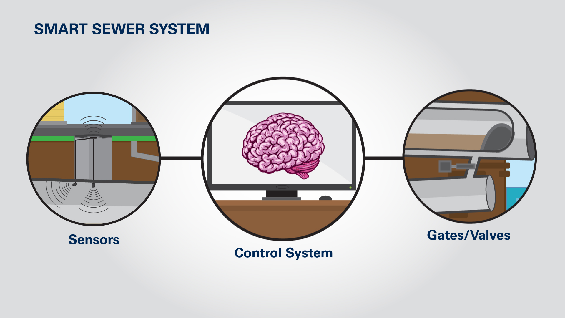
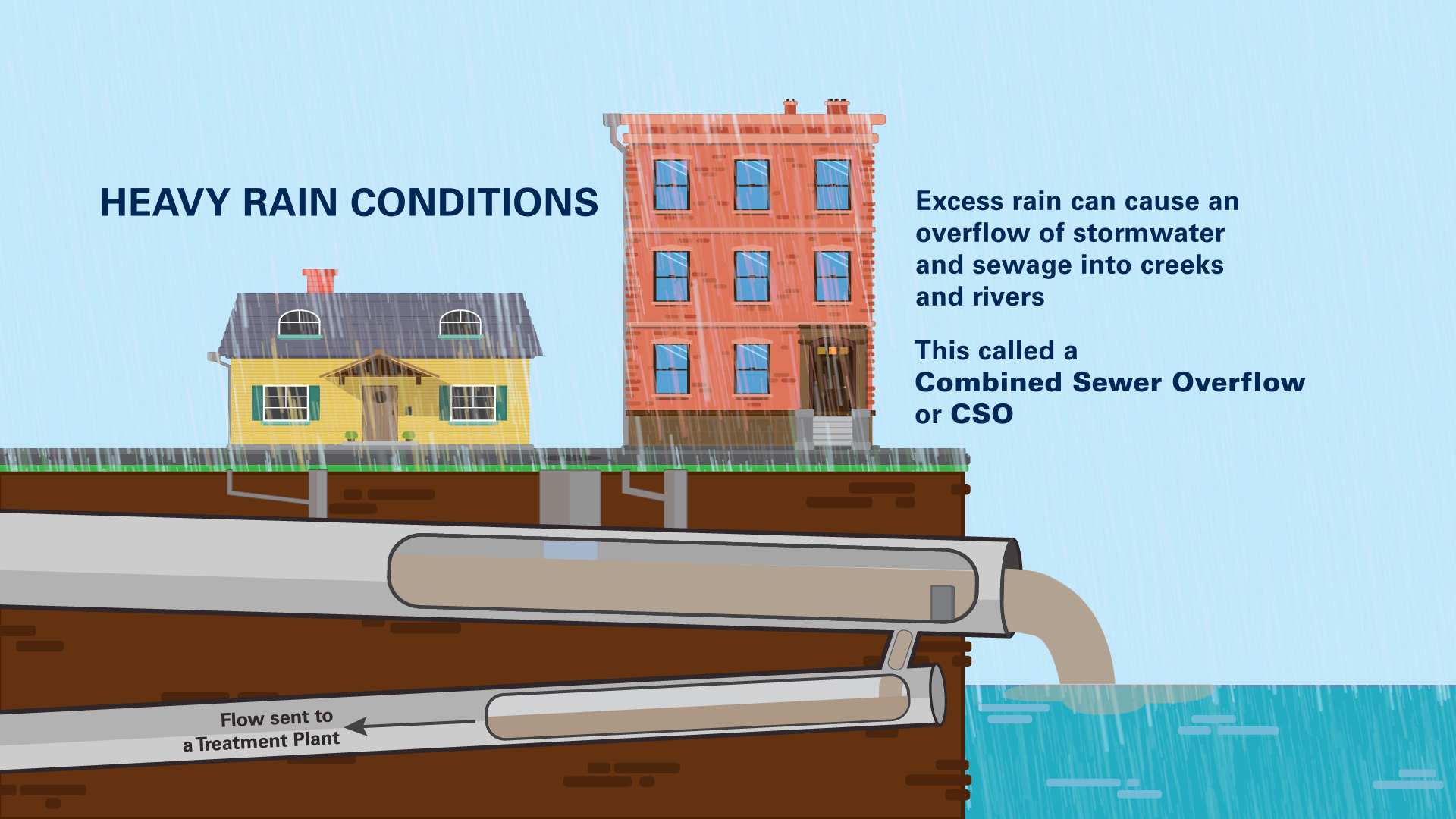 Illustration of a CSO (City of Cincinnati)