Categories
News Transportation

City Planners Recommend Transportation Overlay District for Wasson Railroad Corridor

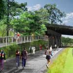
Following the guidance of City Council, Cincinnati’s Department of City Planning & Buildings has completed its land use study for the Wasson Railroad Corridor. The study’s findings and recommendations offer the clearest guidance to-date as to how to proceed with redeveloping the abandoned freight rail corridor, following the issuance of preliminary designs in July 2014.

City planners took a comprehensive look at the history of the corridor, its current conditions and the best path forward that respects the desires of the city and the impacted neighborhoods.

In that analysis City staff revealed seven studies and plans that recommend the corridor either be used for rail transit, or a combined multi-modal network that accommodates rail transit, bicycles and pedestrians. Some of the most notable of these include the 2002 MetroMoves regional transit plan, 2010 Bicycle Transportation Plan, 2012 comprehensive Plan Cincinnati, and the 2013 Railroad Safety Improvement Plan – all of which either specifically call for the corridor to be used for rail transit, or a multi-modal corridor.

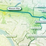
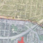
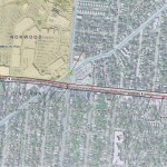
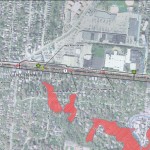
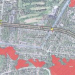
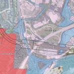
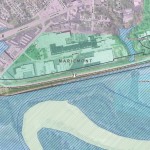
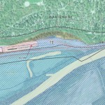
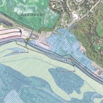
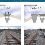
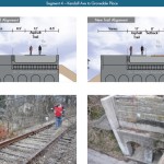
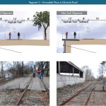
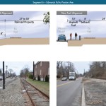
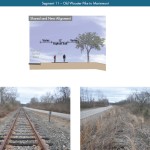
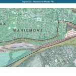
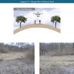
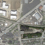
The history is important as it influenced the study’s recommendation as to how to proceed with acquiring and preserving the corridor. As of now, the 5.7-mile Wasson Railroad Corridor is still owned by Norfolk Southern, but the City of Cincinnati has stated that they are in the process of acquiring the property from them.

“With this corridor being so crucial to the future development of multi-modal transportation in the City, the threat of potential development within the railroad right-of-way would significantly slow down, if not completely hinder, those possible public transportation opportunities from occurring,” city planners wrote in the 32-page land use study released earlier this month.

Of course, this fact has been known by policy makers at City Hall for years. As a result, City Council has, on several occasions, approved interim development controls to protect the corridor from being built upon. These controls, however, are just temporary and city officials must now decide how they would like to move forward.

In the study city planners examined the pros and cons of three potential options for accomplishing this.

The first option examined the idea of rezoning the property to a Parks and Recreation classification. This would offer the corridor significant protections, but it would also severely restrict the City from being able to implement rail transit in the future due to federal regulations that prohibit the use of public parks or wildlife refuges for transit corridors.

A second option studied looked at simply dedicating the land as City right-of-way. This too would offer significant protections, but is not possible until the City acquires the land from Norfolk Southern.

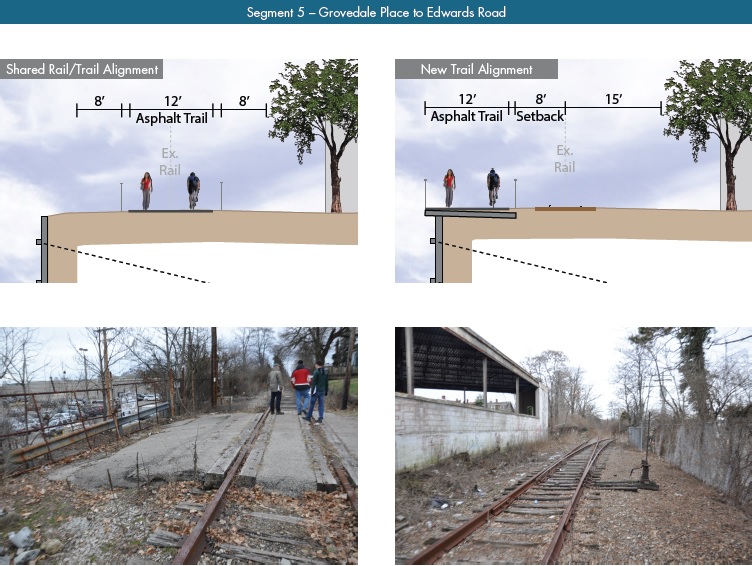
The third option, and the one recommended by city staff, is enacting a Transportation Overlay District over the corridor. While planners admit that crafting the language for such legislation may be complicated, they also stated that it would be most aligned with the preferences of neighborhood residents and publicly adopted planning documents.

In order to address the complexity of the legislation required for such an overlay district, city planners recommended looking at the Atlanta BeltLine Overlay District that was implemented to protect a 22-mile abandoned freight rail corridor. In Atlanta civic leaders are currently in the process of converting the corridor into a similarly envisioned multi-modal network with rail transit, bikeways, parks and pedestrian paths.

“While all options present advantages and disadvantages, the Transportation Overlay District is seen as the best solution for preservation of the Wasson Railroad Corridor,” city planners wrote. “This tool, while it may take a bit longer to craft the ordinance language, will provide more flexibility and also protect the contiguous nature of the corridor.”

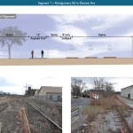
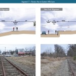
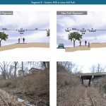
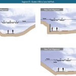
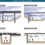
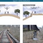
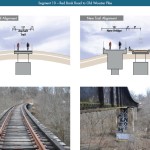
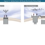
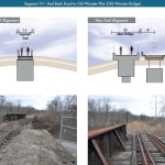
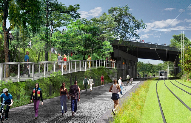
City officials say that this solution will allow for the development of the Wasson Way Trail to move forward in the near term, while affirming the City’s intentions to develop the corridor as a multi-modal transportation facility that includes rail transit in the future.

The solution crafted by the Department of City Planning & Buildings appears to be a perfect compromise between the two constituencies looking to use the corridor. Bicycle advocacy groups can see the right-of-way acquired and preserved so that they can move forward with their plans for a bike and pedestrian trail, while transit advocates can rest assure that those immediate efforts are not being done in conflict with ongoing planning and design work for a future light rail line.

With the Wasson Railroad Corridor Land Use Study now complete, it will go before the city’s Planning Commission. Should it be approved by Planning Commission, it will then go back to city staffers so that draft overlay district language can be crafted and recommended to City Council. From there, it would go before City Council for approval.

It is a standard process and one that advocates hope can be completed in the coming months.

Categories
Month in Review

Month in Review – July 2014

The Banks and Dunnhumby Centre tower cranes In July, UrbanCincy reported on the future of the much-discussed Wasson Way corridor, and investigated the candidate that will most likely be chosen as Cincinnati’s next City Manager. We also opined on the need for a new first-class arena in the city.

Additionally, two of our most popular stories were photo updates: Jake Mecklenborg’s collection of photos from the Northside Fourth of July parade, and my gallery of residential construction projects in Downtown Cincinnati.

Check out our top five stories from July 2014:

    1. PHOTOS: 49 Shots from the 2014 Northside Fourth of July Parade
      Aside from being one of the most significant and well-attended parades in the region, the Northside Fourth of July Parade is also one of the more eclectic.
    2. KZF Releases Preliminary Designs, Cost Estimates for Wasson Way
      The 45-page study is the first detailed look at the corridor, which has been hotly debated and discussed over recent years. Much of the controversy has surrounded whether or not both light rail and a trail can be accommodated.
    3. EDITORIAL: It’s Time for Cincinnati to Build a New First-Class Arena
      Within a one-hour drive from Fountain Square there are eight arenas with a capacity of more than 9,000 people for their primary tenants. Of these, only three have been built or undergone major renovations since the year 2000.
    4. What Does Harry Black’s History Tell Us About His Capability of Managing City Hall?
      It has also been widely reported in the Baltimore and Richmond media that Black earned the nickname of being “the mayor’s bull dog” and “Baby Wilder” in reference to former Richmond mayor L. Douglas Wilder.
    5. PHOTOS: Construction Progressing on Thousands of New Downtown Residences
      Eleven new developments are expected to add about 1,500 new units of housing to the urban core.


Categories
Development News Transportation

KZF Releases Preliminary Designs, Cost Estimates for Wasson Way

A newly released feasibility study, produced by KZF Design, finds that construction of the 6.5-mile Wasson Way Trail would cost anywhere from $7.5 million for just a trail to $36 million for both a light rail line and trail totally separated from one another.

The cost estimates vary so much due to the three potential design options studied. The lowest cost alternative looked at placing a 12-foot-wide trail along the entire existing rail alignment. This, however, would make the inclusion of a future light rail line extremely difficult.

The most expensive alternative would construct an entire new trail alignment that does not interfere with any existing rail right-of-way. This would include the construction of several new bridges and completely preserve the ability to easily construct the long-planned light rail line adjacent to the new trail.

Alternative B, which was recommended by KZF and priced at $11.2 million, was a bit of a hybrid. It would include a 12-foot-wide trail offset from the existing rail alignment, but utilize existing rail right-of-way at pinch points along the corridor.

The 45-page study is the first detailed look at the corridor, which has been hotly debated and discussed over recent years. Much of the controversy has surrounded whether or not both light rail and a trail can be accommodated. KZF’s findings appear to show that much of the corridor could in fact accommodate both, but that some segments may prove to be difficult, albeit feasible.

If project supporters are able to advance the trail plan, KZF estimates that it would connect eight city neighborhoods and approximately 100,000 residents with an overall network of more than 100 miles of trail facilities.

“It is hard to build in the urban core, and to find an intact corridor ripe for development is a unique thing,” explained Eric Oberg, Manager at the Midwest Rails to Trails Conservancy. “If this is done right, this can be the best urban trail in the state of Ohio. I have no doubt.”

Some of the most difficult segments of the corridor are the nine existing bridges where the right-of-way is extremely limited. If both light rail and trail facilities are to traverse this corridor together, additional spans will be needed in order to have safe co-operation.

In addition to introducing what may become the region’s best urban trail and light rail corridor, some proponents also see it as an opportunity to fix other problems along the route. Most notably that includes the congested and confusing intersection of Madison, Edwards and Wasson Roads near Rookwood Pavilion.

While the newly released feasibility study offers the most detailed analysis of this corridor to date, the City of Cincinnati has yet to close on its purchase of the former freight rail line from Norfolk Southern.

City officials are reportedly in negotiations with Norfolk Southern now, and have made an initial offer of $2 million. In April, Mayor Cranley’s Administration also allocated $200,000 to the project.

Categories
Business Development News

Greiwe Development to Break Ground on $35M Hyde Park Condo Building This Week

Developers are aiming to break ground on a $35 million condo building in Hyde Park this week, following a months-long demolition effort that began in late October and cleared the site of five existing buildings, some of which dated back 80 years.

Greiwe Development and North American Properties (NAP) say that the demolition work cleared the way for what will become a modern four-story building that will house 30 luxury condominiums at the corner of Observatory Avenue and Shaw Avenue in Hyde Park.

Named 2770 Observatory, the development will also include a 77-space underground parking level accessible from Shaw Avenue.

The development will boast some of the priciest new residences in the region, with units priced between $700,000 and $2 million.

“Hyde Park combines the sophisticated lifestyle of Cincinnati’s premier neighborhood with the exciting air of arts, innovative restaurants and blocks of unique shopping,” said Rick Greiwe, principal of Greiwe Development.

Not everyone is thrilled about the luxurious direction in which Hyde Park continues to head. Former residents expressed frustration to UrbanCincy, saying they were given notice to vacate their apartments “by the end of the month” so that demolition work could proceed.

Over the years, this transition has led to a migration of priced-out Hyde Park residents to seek more affordable options nearby in Oakley, East Hyde Park or Evanston.

Griewe, however, says that the vibrancy of Hyde Park Square is part of what drew his development team to this location, and that the active and engaging lifestyle of city living is what is appealing to his firm.

Both Montgomery and downtown Cincinnati are locations where Greiwe says they would like to do additional work.

The announcement of 2770 Observatory comes as a wave of residential infill projects have been sweeping across Cincinnati’s neighborhoods. Thousands of new residential units are either currently under construction or planned to get started soon in Northside, Walnut Hills, Downtown, Over-the-Rhine, College Hill, Corryville, Clifton Heights, Columbia Tusculum and Avondale.

Instead of the residences being rentals, as is the case for most other projects around the region, 2770 Observatory follows in the footsteps of 2801 Erie Avenue and Michigan Terrace, which were completed in 2009 and 2007, by injecting high-end condos into one of the city’s toniest neighborhoods.

Griewe Development has become known for high-end, urban residential projects. In Mariemont, the company has completed 106 units in the heart of the village. That overall development program has been built over four different phases including Emery Park, Nolen Park and Jordan Park.

The development team says that they are pursuing a LEED Silver certification for the Hyde Park project, and that it is being completed without any financial assistance from the City of Cincinnati.

Cincinnati-based GBBN worked as the lead architecture firm on the project, while Messer Construction has been selected to build it in conjunction with NAP. Construction work is expected to begin this week, with units becoming ready for occupancy in fall 2015.

Categories
Business Development News

Indianapolis Developer to Continue Oakley’s Housing Boom with 272-Unit Project

Yet another Indianapolis-based developer is entering the hot Cincinnati residential market. This time the developer is Buckingham Companies and the location is Oakley.

According to the Business Courier, an UrbanCincy content partner, Buckingham has been eyeing the Cincinnati market for some time. They decided that now was the time to move on the seven-acre site immediately southeast from the $120 million Oakley Station development which will include nearly 600,000 square feet of office and retail space, 302 apartments and a movie theater at full build out.

The developers are citing the location’s close proximity to Downtown and the neighborhood walkability offered in now-booming east side city neighborhood as the main draws.

Buckingham hopes to break ground on the project this May and open the summer of 2015. At full build out the project will include 272 apartments in seven, three-story buildings. Residences will range from 812 to 1,600 square feet and likely cost around $1 to $1.50 per square foot.

The development says that they will pursue LEED for Homes, the U.S. Green Building Council‘s newest Leadership in Energy and Environmental Design certifications, for the project.

The site is located immediately adjacent to a freight rail line owned by CSX, and currently includes two industrial warehouse buildings and approximately 11 single-family homes along Cardiff Avenue. Both the homes and the warehouses date back to the early 1900s. Initial reports indicated that the developers may renovate one of warehouses into 41 apartments.

The project announcement comes immediately after the developers acquired seven of the properties earlier this week. Of the remaining five homes, three are held by separate, unaffiliated LLCs and the other two are listed by the Hamilton County Auditor as owned by individuals who live elsewhere.