Civic Cincinnati is Cincinnati’s Strong Towns Local Conversation group. Strong Towns advocates for cities to be safe, livable and inviting, with a pattern of development that’s financially strong and resilient.
That doesn’t describe Hyde Park Square today. It shows a lack of vibrancy demonstrated by the paucity of people walking and congregating there. By removing buildings that have not kept up with modern building standards and renovating another building, the developer hopes to change this, bringing new residents and visitors to the Square and its businesses.
Every city neighborhood has concerns about traffic safety, especially for vulnerable children. Blaming development for furthering these problems denies the reality that additional density actually improves pedestrian safety.
More people walking through and around Hyde Park Square sends a signal to drivers to use caution when driving there. That, in turn, encourages more people to walk rather than drive. Hyde Park can continue to improve safe and comfortable walkability by making further traffic calming enhancements a priority for future budget requests.
While neighborhoods have an important voice in development plans, their concerns must be tempered by the need to build more housing city-wide. Giving neighborhoods veto power over development will not lead to the kind of strong, resilient neighborhoods the city needs, and which this council has bravely stood up for.
Every new project promises to change the familiar landscape neighborhood residents consider their home. Planning for opposition needs to be an important element of the process. The city can’t afford to allow that opposition to prevent the progress we must make to increase housing at all levels and price points. That’s what we’ve elected you to do – make the hard decisions that benefit the entire city.
Connected Communities is a first step in unleashing the power of zoning reform to increase housing in Cincinnati. No neighborhood can be exempt from change. We support efforts for the developer and their intermediary to work with Hyde Park’s residents, businesses, community council and organizations on a design that will make all of them proud of their community in 20 years.
We love Cincinnati. We want to stay here. Many of us are recent college graduates or in the early stages of our careers. We’re finding it tough to find rental housing in neighborhoods where we want to live, and buying a house seems like an impossible dream.
We need our city leaders to recognize that we’re the city’s future. Our needs are as important as those of longtime residents who oppose the development our city needs to house us now, and attract more of us to make our lives here.
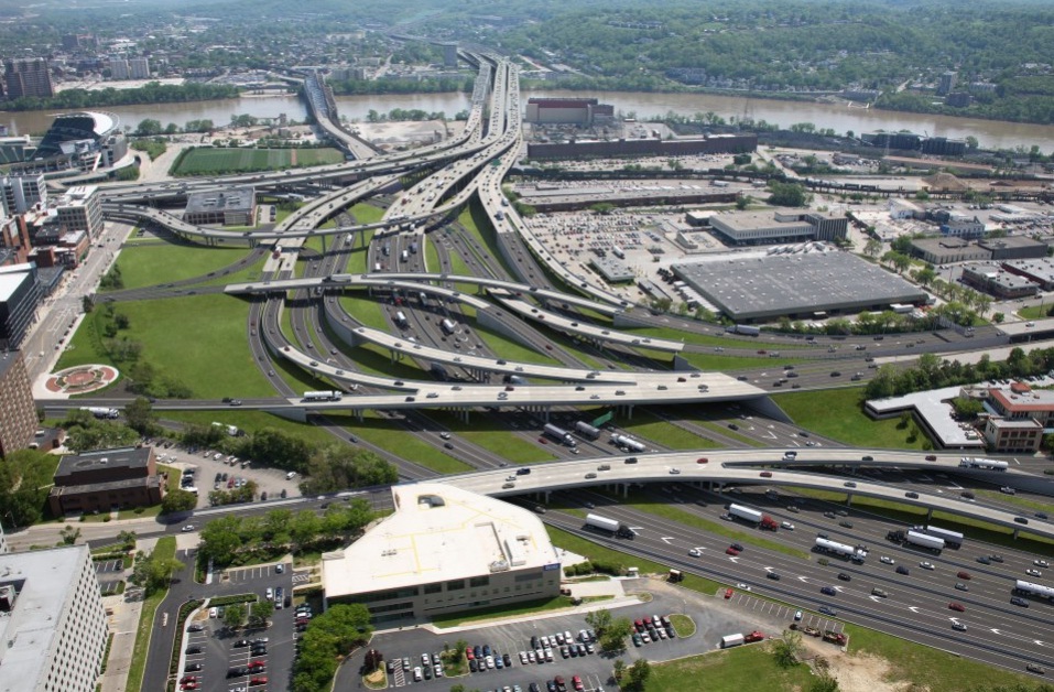
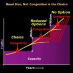
The underlying assumption of the Brent Spence Bridge project is that the level of congestion warrants relief with a new bridge and freeway expansion. The problem of congestion will be solved with new freeway capacity. However, that simple formula does not account for all the costs of the freeway expansion or the benefits not running a freeway through the urban core.
Two important pieces missing from the Brent Spence Bridge project cost/benefit analysis are the value of urban land and induced demand. As noted in a prior article, urban land is valuable. The sustained growth in Over the Rhine is local proof of the national trend that people want to live, work, and play in cities. Proponents of the bridge expansion project assume that the congestion relief is worth the price tag and loss of urban land for the next 50+ years. But what if the congestion relief is ephemeral?
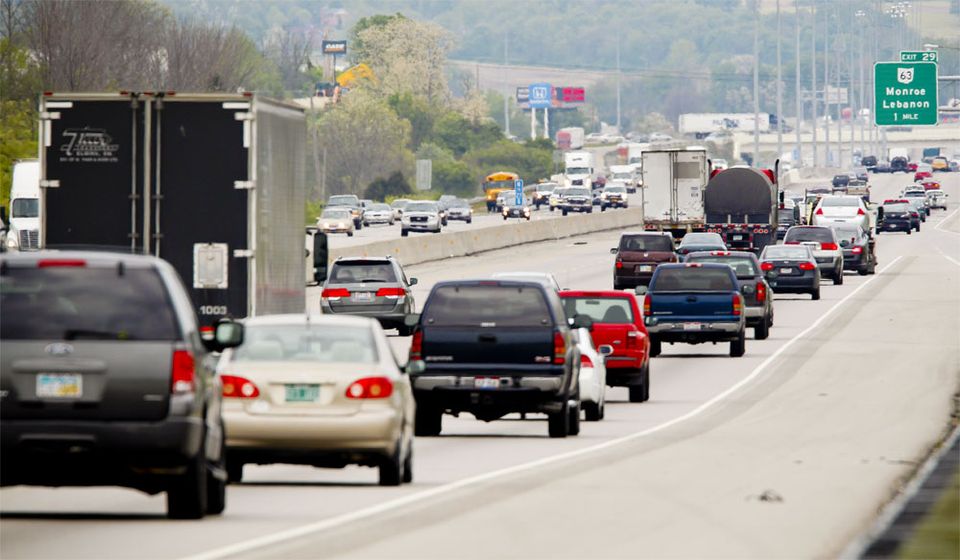
Others in Cincinnati have described induced demand. To reiterate, it is the propensity for freeway lanes to fill to capacity once they are created. New capacity creates new demand. Decreasing the cost of driving with shorter, faster commutes, increases the number of drivers. Road expansions are intended to expand capacity and reduce congestion; however, new freeway capacity quickly fills up and becomes just as congested as before.
Proposed approach to the Brent Spence Bridge, Kentucky side
Katy Freeway in Houston Texas
OKI Projected congestion model for 2012
OKI future traffic model for 2039
A chart illustrating Induced Demand
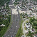
There appears to be no upper limit at which enough lanes eliminate capacity. The Katy Freeway in Texas provides the case in point. First constructed in the 1960s, it was six to 8 lanes wide. A $2.8 billion expansion project finished in 2011 that expanded it to one of the widest freeways in North America at 26 lanes: At one segment each direction has 6 lanes of through traffic, 4 feeder lanes, and 3 HOV/toll lanes. Travel times decreased immediately after the expansion, and in 2012 the Katy Freeway was hailed as a success story. However, by 2014, travel times increased 30 percent during the morning commute and 55 percent during the evening commute. $2.8 billion and 18 extra lanes improved traffic for three years, then made it worse than before the project. It achieved congestion relief for less than three years.
The predicted benefits of the Kary Freeway did not last. Cincinnati should learn from that lesson and include the effects of induced demand in the Brent Spence Bridge expansion cost/benefits accounting. The previous design did not adequately analyze induced demand.
Part of the reason that the project did not include induced demand as part of the analysis is that the software used to model traffic volumes is not up to the task. The model, called Static Traffic Assignment (STA), was designed to run on computers from the 1970s. Since you are reading this article on a computer there is no need to explain how much computers have changed in that time. There have been upgrades to the STA software but it retains the same fundamental architecture. STA produces usable predictions for daily traffic volumes but not for peak demand (rush hour). Accurate predictions of peak demand are necessary to understand induced demand.
There are two problems with STA that provide inaccurate peak demand forecasts. First, STA assumes roadway segments are independent, so that a problem in road segment “A” will not impact road segment “B.” In reality, congestion in one road segment does impact adjacent segments. Second, STA allows modeled traffic volumes to exceed capacity. If the model predicts capacity beyond what a given freeway can support, the model will queue vehicles up “outside the model.” In reality, those cars queued “outside the model” are either stuck in traffic or they’ve left the freeway and are taking surface roads to work.
The interstate system is a network that seeks equilibrium. If there is congestion in the network, drivers will avoid it. If there is capacity in the system, drivers will fill it up. The current Brent Spence Bridge project was modeled with STA. STA does not look at the network holistically. It either breaks up the system in segments or moves extra traffic outside the model. The failure to look at the system holistically makes it difficult for STA to predict where induced demand will come from and how intense the demand will be.
A better model now exists to forecast traffic. Called Dynamic Traffic Assignment (DTA), it is a more sophisticated computer model designed to run on contemporary computers. DTA holistically models an interconnected network in equilibrium. If a bottleneck causes a traffic backup, DTA assumes traffic will divert to surface roads rather than move outside the model.
The 2018 CNU Transportation Summit on Highways to Boulevards featured the presentation of a recent paper on DTA. Overall, DTA is a more powerful modeling tool that can better analyze effects on complex systems. There are five vehicular bridges over the Ohio River in Cincinnati, plus the two I-275 bridges. The traffic model must accommodate the regional impact of the bridge expansion on traffic, including the effects of induced demand. This is doubly important if the Brent Spence Bridge expansion is tolled and other bridges are not.
Existing Brent Spence Bridge Approach
Planned Brent Spence Bridge Approach
A DTA model of the Brent Spence bridge project will better show the impact of additional vehicles on local streets. Civic leaders in Cincinnati and Covington should have a better accounting of how moving an additional 50,000 vehicles per day through the urban core will affect their street networks, which must be paid for with city tax dollars.
Would it make sense to spend five years building the expansion project if the congestion relief dissipated within five years? Before moving ahead with such a large and expensive project there must be a full accounting of the costs and benefits. Particularly relevant to CNU, the loss of urban land has not adequately been included in the cost of the project. The benefit of congestion relief is diminished by induced demand. There are new tools at hand to better tally up these costs and benefits. A project the size and scale of the Brent Spence bridge expansion project requires a full and transparent accounting of the costs and benefits to move forward.
This is a guest article by Chris Meyer reporting on the 2018 CNU Transportation Summit. CNU and CNU Midwest are content partners with UrbanCincy. Chris is an Architect at Hub + Weber, PLC
If you would like to have your thoughts and opinions published on UrbanCincy, simply contact us at editors@urbancincy.com.
CNU’s 2018 Transportation Summit was September 16-17 in New Orleans. The purpose of the summit was to bring together people focused on the revitalization of urban neighborhoods disrupted by freeways. In attendance were people from Massachusetts, California, Colorado, Texas, Wisconsin, Washington DC, and two members from CNU Midwest, Chris Meyer and Brian Boland. There were many takeaways from the summit but three lessons seem applicable to Greater Cincinnati.
The first is that freeways and urban fabric are incompatible. Urban fabric in Greater Cincinnati typically consists of fine-grained parcels, 2-5 story buildings, and a dense street with grid pedestrian-scale streetscapes. Urban fabric is fundamentally sized for people. The 19th century blessed present-day Greater Cincinnati with an abundance of high-quality urban fabric. A minor takeaway from the transportation summit was that other cities would be jealous if they knew what we have.
Freeways are scaled for cars and trucks. They are always interruptions in the urban fabric. They break up the street grid wherever they pass through it and form barriers to people passing. The urban fabric for blocks around a freeway is degraded not only by the dirt, noise, smell, and ugliness but also by the profusion of vehicles they concentrate and deliver into the urban fabric. This is true for greater Cincinnati along the I-75, I-71, and I-471 corridors.
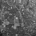
The aerial photo from 1955 shows the abundance of urban fabric. Orient yourself with union terminal at the left and downtown Cincinnati on the lower right. The west end is on the lower and middle left.
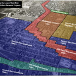
Graphical estimation of Urban Renewal projects in the West End. Illustration by John Yung
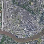
The white square from photo 1 is highlighted in photo 2. The west end was demolished and replaced with I-75 and the Queensgate industrial area.
Freeways are a necessary part of the urban economy but they are incompatible with the urban fabric. It was a mistake to run them through central cities. Dwight Eisenhower, the father of the interstate system, certainly thought so.
Multiple people at the summit noted that urban freeways are “monuments to racism.” That’s obviously the case in New Orleans. In Cincinnati, the West End neighborhood is physically gone but the Kenyan Barr photo exhibit, currently showing at the University of Cincinnati, illustrates the neighborhood destroyed by I-75. Ninety-seven percent of the residents were black.
A second lesson from the transportation summit is that urban fabric is valuable. Anyone familiar with CNU understands that. What was new is that urban fabric can be more valuable than the freeways running through it. Implicitly or explicitly, a big part of the argument to remove freeways, be it Denver, Oakland, or Austin, is to free up land for profitable new development.
The same principle applies to Cincinnati. The value of land with urban development on it is greater than the same amount of land with auto-centric development on it. The blocks around freeways are almost always taken up with auto-centric development because of how freeway ramps concentrate vehicles in a geographic space. Cincinnati would reap greater economic, tax, and social benefits if the space around Interstate-75 followed urban development patterns rather than auto-centric development patterns.
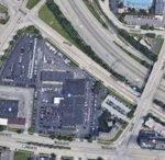
Auto-centric development near the urban core.
Pedestrian-scale development near the urban core.
The third lesson is that the future of urban development doesn’t have to look like the past. When the first Congress for New Urbanism met in 1991, most new development was going to suburbs and central cities were still losing money and population. That has changed. People are moving back to places where they can live, work, and play, without a car. It’s happening in Cincinnati too.
Recognizing the value of urban fabric and the cost of freeways in the urban fabric allows people to recalculate the costs/benefits of future transportation projects. Two high-profile Cincinnati transportation projects include the Cincinnati Bell Connector streetcar and the Brent Spence Bridge expansion.
One argument against the streetcar is that it is not “profitable,” so it should be shut down. However, streetcars are compatible with the urban fabric. Most buildings and parcels on the streetcar route have been improved. Streetlife – outdoor dining, social interaction, economic activity – along the streetcar route is as vital as it’s been for decades. The streetcar is a fellow dancer in the sidewalk ballet. It improves the value of adjacent urban fabric, in opposition to freeways that destroy value. A better cost/benefit analysis of the streetcar would include the increased tax value derived from adjacent improved parcels.
The inverse argument occurs with the Brent Spence Bridge project. The primary cost/benefit evaluation looks at congestion. The potential value of restored urban fabric has never been a part of the bridge’s cost/benefit analysis. When they factored the value of urban fabric into the Fort Washington way redesign, they decided to sink the freeway below grade so it could be capped in the future. It’s easy to envision a redesigned bridge project that includes land for new urban fabric, much as the Fort Washington Way project did.
Bridge redesign vision from UC’s Niehoff Urban Studio that incorporates new urban fabric.
Image from 2010 Revive-75 Study considered moving 75 further west adding 22 blocks to the Central Business District.
Planned Brent Spence Bridge Approach
The 2018 CNU transportation summit brought together thought leaders, local activists, transportation professionals, and city designers. A repeated statement at the 2018 summit was that multi-million dollar infrastructure projects should improve the value of places where they are constructed. In Greater Cincinnati, it seems like the value of place is often not considered in the cost-benefit analysis of large transportation projects.
In the past, it was possible to argue that urban fabric had no value, or that its value was equal to auto-centric development. Those arguments can no longer be made in good faith. If Cincinnati is going to capitalize on the wealth of its urban fabric, the value of that fabric must be included when evaluating future transportation projects. If it’s done so accurately, we should be all the wealthier.
This is a guest article by Chris Meyer reporting on the 2018 CNU Transportation Summit. CNU and CNU Midwest are content partners with UrbanCincy. Chris is an Architect at Hub + Weber, PLC
If you would like to have your thoughts and opinions published on UrbanCincy, simply contact us at editors@urbancincy.com.
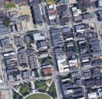
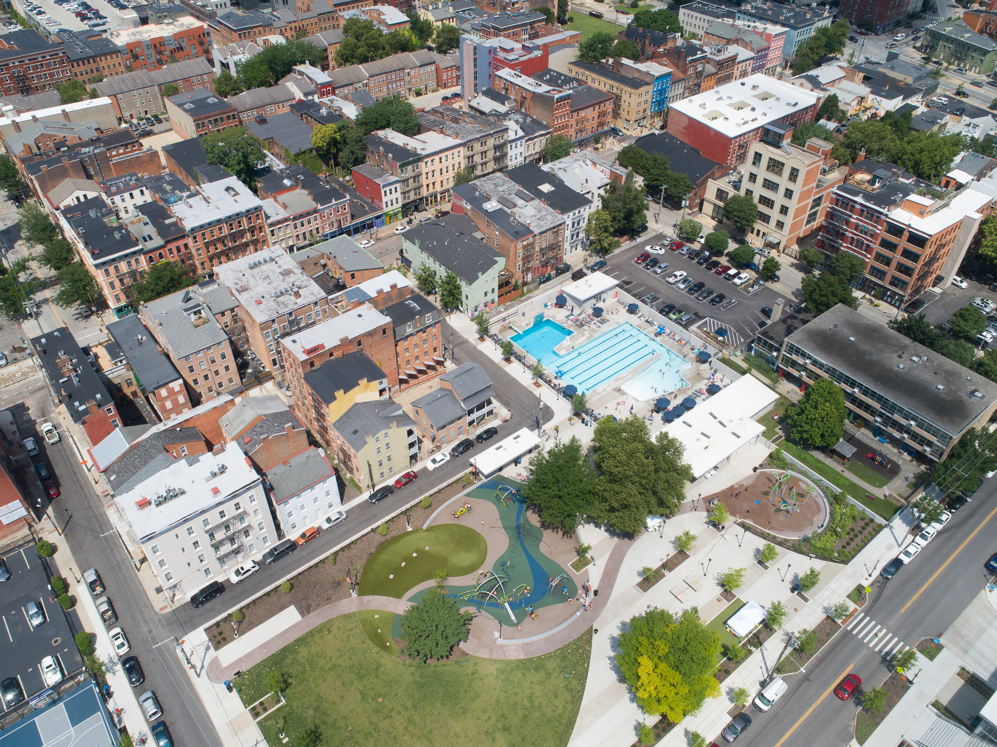
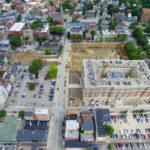
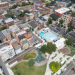
Aerial of the completed Ziegler Park [Photo by Travis Estell]
Since its inception, the revitalization of city-owned Ziegler Park has helped to foster not only a stronger sense of community but also an increase in investment and development in the Over-the-Rhine and Pendleton neighborhoods. The park straddles Sycamore Street between Thirteenth and Fourteenth streets and for many years was a poorly maintained, crime-ridden hub for drug activity.
However, in 2012 Cincinnati Center City Development Corporation (3CDC) approached the City of Cincinnati with the idea of redeveloping the park in an effort to combat the disinvestment the area had been experiencing. Soon after, a team was put together through the Cincinnati Park Board and the Cincinnati Recreation Commission (CRC) to gather community input on a new vision for the public space.
Ziegler Park under construction [Photo by Travis Estell]
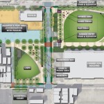
Ziegler Park Preliminary Master Plan [Provided]
Aerial of the completed Ziegler Park [Photo by Travis Estell]
Ziegler Park Rhino’s Swim Team [Photo Provided]
The project broke ground in January 2016 and was completed during the summer of 2017. The massive $32 million transformation allowed Ziegler Park to expand from 1.5 acres to 4.5 acres and also included a game grove, pool, sprayground, basketball courts, children’s playground and a 400-space underground parking garage.
One of the most significant additions to the park–and to the neighborhoods of Pendleton and Over-the-Rhine in general–has been the brand new 400-space parking garage. The garage helps to alleviate some of the parking challenges experienced by residents, business owners, and visitors and even displays the amount of open spaces left in real time at the entrance to the garage as well as on the Ziegler Park website.
Since November 2015, when the Cincinnati City Planning Commission recommended approval of the park revitalization, the properties surrounding the park have experienced a wave of momentum. Over 30 building permits that have been issued to date for repairs or alterations within a quarter mile radius of the park.
Some of the more notable projects completed include the addition of new businesses adjacent to or near to the park. The Takeaway Deli & Grocery, Pendleton Parlor Ice Cream & Cookie Dough, Boomtown Biscuits & Whiskey, The Pony, Allez Bakery, Brown Bear Bakery have opened or are slated to open later this year. Rosedale, Revel, The Hub, Treehouse Bar, Longfellow, 3 Points Urban Brewery round out the list.
The additional parking capacity has also allowed office projects like the new Empower MediaMarketing’s new office location on 14th street to be constructed.
The enhancements alone have provided the community with a space to gather, play, relax, and enjoy the outdoors. In addition to these improvements, the Everybody In program helps maintain Ziegler’s commitment to inclusivity by making pool memberships affordable regardless of income.
The program also provides free programming for youth including swim lessons, summer camp, and basketball games. The Everybody In program receives its funding from Procter & Gamble (P&G) and the Ohio Capital Corporation for Housing (OCCH).
The revitalization of the park coupled with its accessibility has increased the amount of foot traffic in the area, which in turn, has bolstered the economic development of the community overall. Now considered a neighborhood asset as opposed to a challenge, Ziegler has become a destination for families and individuals coming from a variety of backgrounds and incomes.
For example, the creation of the Rhino’s Swim Team is one of the many opportunities that arose from the revitalization of the park. The team, focused on community youth, has no registration feel and is supported through donations.
Although Ziegler Park’s dramatic transformation is probably not exclusively responsible for the boost in economic development in Over-the-Rhine and Pendleton, it is fairly safe to assume that this revitalization has been catalytic. What was once a hub for crime and drug trafficking is now a safe community space that is accessible to all incomes and provides the neighborhood with assets that are essential for a higher quality of life. The redevelopment of this public space has proven that its value extends beyond the boundary of the park itself.
Recently, the Cincinnati City Planning Department sent out a notice to property owners in downtown and Over-the-Rhine regarding the implementation of an Urban Parking Overlay District. The city will hold several meetings with the next one being at the City Planning Commission meeting this Friday, July 27th at 9 a.m. If approved, the district would remove the requirement for uses in downtown to provide off-street dedicated parking.
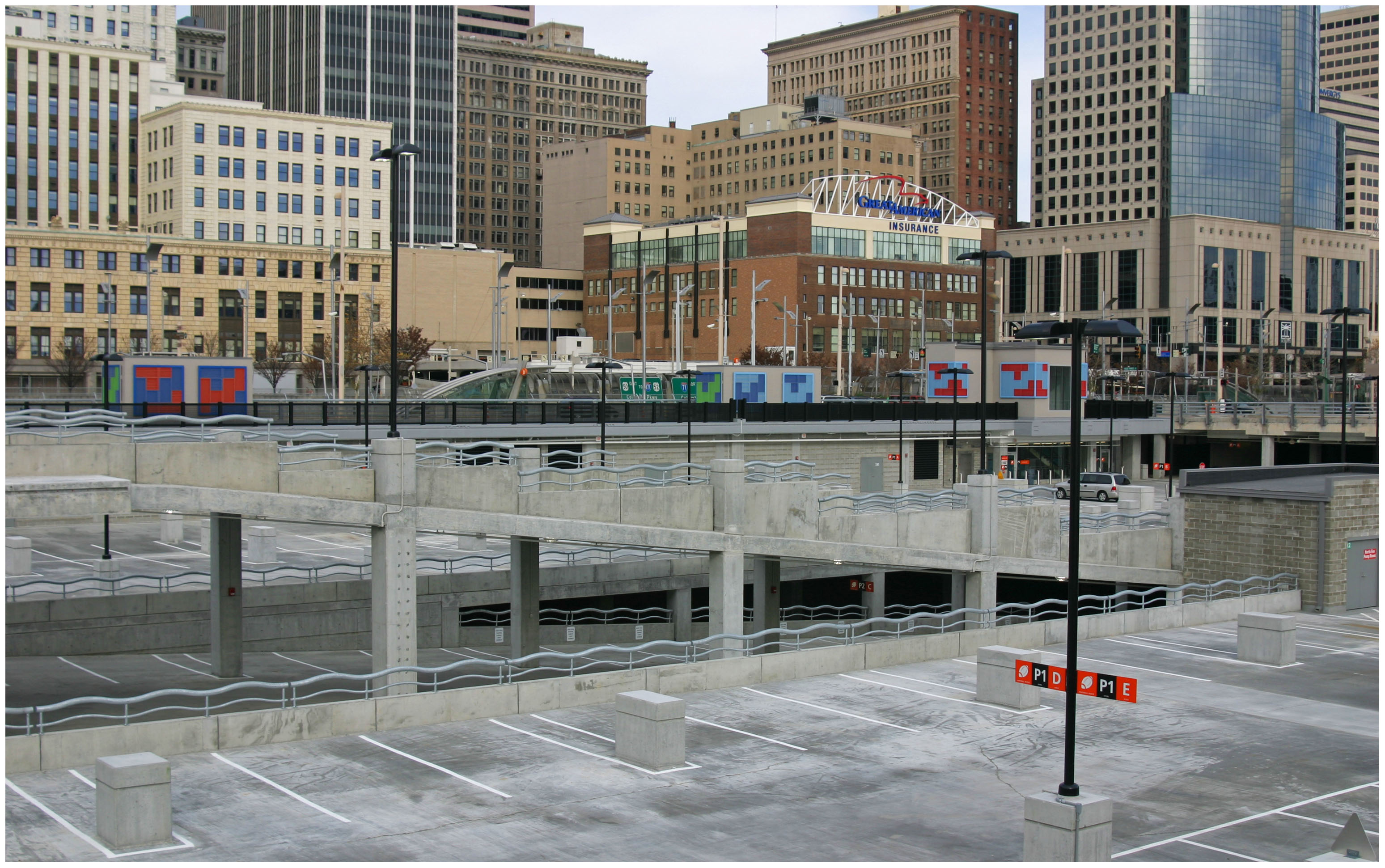
Since 2012 when I first wrote about parking in downtown and Over-the-Rhine the number of off-street parking supplied has increased well over 3,000 parking spaces (38,760 in downtown alone according to DCI). The Banks parking garage alone with over 6,000 spaces is the third largest parking garage in the United States.
We have an abundance of parking in the urban core.
At its core function, the removal of required parking minimums has proven to allow for more creative parking solutions to blossom. As Donald Shoup, parking guru and professor at UCLA found in his book The High Cost of Free Parking, most parking minimums were established as arbitrary standards by planners in the middle of the last century. Many of these requirements are intended to account for the busiest times of the day or year. UrbanCincyinterviewed Dr. Shoup in 2014 regarding a variety of local parking issues.
In Nashville for example, the removal of parking minimums helped remove barriers for small-scale developers who could not afford to acquire additional land for a few parking spaces. Instead, agreements with nearby garages helped facilitate automobile storage demands.
Back in 2012 Nashville Planner, Joni Priest told UrbanCincy, “Removing the parking requirements from downtown zoning allows flexibility for site-specific and program-specific solutions. Flexibility is key in urban environments,” said Priest. “As downtown becomes more comfortable for pedestrians, cyclists and transit users, new development will have the flexibility to build less parking.”
Meanwhile, in Cincinnati, the city continues to struggle with developers looking to build new infill or rehabilitate and reactivate the many historic buildings in the urban core.
The Banks Garage is one of the largest parking structures in the United States [Photo by Travis Estell]
A plethora of parking dots the northwest quadrant of downtown. [Photo by Travis Estell]
Cincinnati Public Radio’s Current Building [Photo by Travis Estell]
Encore Apartments across from massive Joseph Auto Parking Lot in downtown [Photo by Eric Anspach]
Even when parking requirements are reduced or eliminated most banks and investors still require parking to be provided or identified for developments to move forward. Removing zoning requirements for parking often allows the developer to build the parking that is really needed and not what is arbitrarily demanded by local zoning controls. This reduces the cost of development and in turn, allows more affordable housing to be provided.
Removing parking minimums also preserves historic structures from being demolished for parking lots and garages. Over-the-Rhine is the largest collection of German Italianate buildings in the country yet it currently has lost over half of its historic structures. If parking minimums are retained, the demolition of our communities historic assets will continue to be encouraged to meet the city’s parking requirements.
There is an abundance of alternative options to traverse to, from and around the urban core. These modes include walking, biking, CincyRedBike, buses, streetcar, uber, lyft, Gest, and Zipcar. In the near future, we’ll likely see Bird scooters and Lime bikes introduced. In the long-term, improved transit and autonomous vehicles will reduce the need to own and store a vehicle. Every one of these trips is one less parking space needed per resident, worker or visitor.
It would be wise for the City to anticipate criticisms from residents of the urban core. Some of whom recently voiced concerns regarding the increasing struggle to find on-street parking spaces. This is a struggle that is common in many dense, historic urban neighborhoods across the country where the expectation is that it is very rare to snag a parking space directly in front of a persons residence or business. However, it is important to consider this in light of a broader parking strategy, one that would balance resident, business and development demands.
There are a few additional strategies for city policymakers can consider in conjunction with approving the Parking Overlay District to remove parking requirements. Most of these are adapted from Dr. Shoup’s recommendations:
1.) Continue to pursue the implementation of the on-street residential parking permit program.
2.) Add on-street 10-30 minute convenience parking at some spaces around Findlay Market.
3.) Consider opportunities for future public underground parking facilities to serve Findlay Market and the rest of Over-the-Rhine north of Liberty Street.
4.) Enable the demand-responsive capabilities for on-street parking meters. This strategy will encourage more meter usage and could be a potential revenue add for the city’s parking meter program.
As part of a broader plan, it makes sense to remove the parking space requirements in the urban core. To quote Shoup, “If Cincinnati uses fair market prices to manage on-street parking – the lowest prices that will leave one or two open spaces on every block at every time of the day – it won’t have to require off-street parking spaces for every land use. If the government regulated any other aspect of our lives as precisely as it regulates the number of off-street parking spaces everywhere, everyone would join the Tea Party.”
Removing parking minimums is a productive first step in the city’s comprehensive strategy to balance the demands of residents, workers, visitors who help make our urban core a vibrant and attractive place. Supporting this policy is a step in support of enhancing housing affordability, historic preservation, environmental sustainability and livability in our urban core.