Tomorrow at 12pm, City Council’s Strategic Growth Committee will discuss the proposal that would turn the Wasson Corridor from a railroad right-of-way into a recreational trail. What UrbanCincy is urging City Council to require is a minimum of 28 feet worth of right-of-way preserved for future light rail use.
Standard designs for bi-directional light rail traffic require a minimum of 28 feet of right-of-way. Along some portions of the Wasson Corridor it may very well be possible to accommodate 28 feet for light rail, plus additional right-of-way for the proposed recreational trail, and in those segments it may make sense to get started.
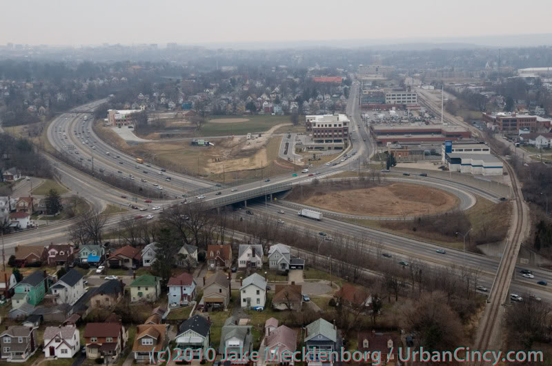
Looking east as the Wasson Line crosses over Interstate 71. Photograph by Jake Mecklenborg for UrbanCincy.
While there is no funding currently in place to build light rail along the Wasson Corridor, it would be short-sighted to remove one of the best rail transit corridors in the city. This was previously done on Cincinnati’s west side when an abandoned railway used by freight and passenger rail traffic was abandoned and then allowed to be built over and occupied by the Glenway Crossings retail center.
Allowing this to take place offered city and county leaders to reap the rewards of a short-term boost, but it has also created a situation that makes building light rail to Cincinnati’s western suburbs almost impossible. This same thing could happen to Cincinnati’s eastern suburbs should the Wasson Corridor be used by a recreational trail.
Proponents of the Wasson Way Trail project made it clear that many of the supporters also want to see light rail eventually happen, but that we should not wait until that day comes to improve the visual appearance of the corridor. Case studies from all over the United States show, however, that once a former rail line is converted into another use, it is almost always an impossible political task to take that land back for rail purposes.
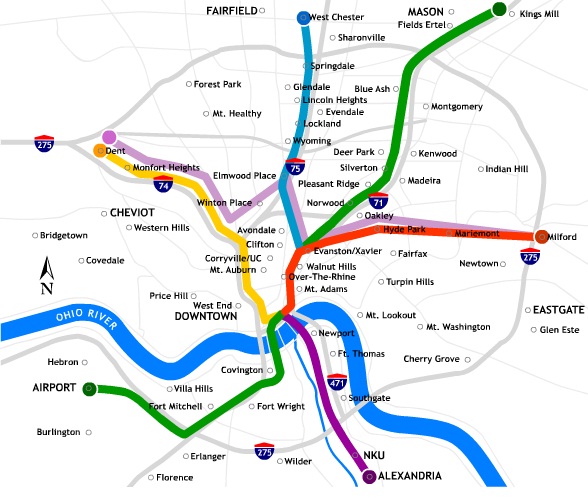
2002 regional light rail plan for Cincinnati.
In the larger scheme of things, UrbanCincy believes that regional leaders need to take a step back and ask themselves why we are still discussing commuter rail along the Ohio River, and a recreational trail through densely populated city neighborhoods. The priorities should be reversed, and the Oasis Line along the Ohio River should be converted into a recreational trail while the Wasson Line is preserved for future light rail use.
It is estimated that the Wasson Light Rail Line would attract three times the number of riders than the Oasis Commuter Rail Line, while also being significantly less expensive to build and operate. Futhermore, when discussions were held about the Oasis Line, residents and property owners along the line voiced their opposition to such activity and have conversely expressed interest in seeing the railway converted into a recreational trail.
City and regional leaders should maintain the natural beauty of the Ohio River and turn the Oasis Line into an attractive recreational trail that can connect into existing trail networks to the east, and the Wasson Line should be preserved for light rail use in the future. It may seem frustrating to leave the Wasson Line in its current state of appearance, but it will be much more frustrating to jeopardize one of the best potential light rail corridors envisioned for the region.
In the post-industrial United States cities all across America have been left with an abundance of rail right-of-way that once served industrial properties. Cities have since struggled to find a use for these rail corridors.
In many cases the rail right-of-way either gets built over, or makes room for some other use – most typically a park or trail of some sort. The most famous, and perhaps most unique, example of this is New York City’s Highline which converted an abandoned freight rail corridor into an elevated park. In most cities, however, much simpler trails are developed in order to cater to bicyclists and pedestrians.
These are great projects, but in the cases where rail right-of-way is needed in order to introduce rail transit, they should not be done. The acquisition of right-of-way can be one of the most difficult hurdles to clear when developing rail transit, so if you have a prime corridor intact, you should do everything in your power to preserve it for future rail transit.
Map of the proposed Wasson Way Project.
The reason this is particularly important in Cincinnati right now is because on March 6, advocates of what is being called Wasson Way Project will present their ideas for converting the Wasson Corridor into a bike/ped trail to City Council’s Strategic Growth Committee.
The idea is not a bad one on face value, but should it proceed it would eliminate one of the most valuable rail corridors in the city. A corridor that could connect neighborhoods like Hyde Park, Oakley, Evanston, Norwood, Mt. Lookout, Fairfax and Mariemont with light rail and eventually connect those neighborhoods to the region’s two largest employment centers – uptown and downtown – without much additional track or right-of-way acquisition.
“I know of no example in the United States where a former railway that has been converted to a bike/hike trail has ever been returned to passenger rail service,” explained Cincinnati transit advocate John Schneider (aka “Mr. Transit”). “Once it’s gone, it’s gone.”
Rail corridors that run through areas of limited potential transit ridership like the Oasis Line should be redeveloped into trails. It just makes sense. There is less automobile traffic and the riverfront trail provides a scenic ride for bicyclists and connects its users to a string of riverfront parks.
The Wasson Line, however, is ripe for light rail service with its densely populated neighborhood, vibrant business districts and key attractions along the line. The Oasis Line should become a bike/ped trail, but the Wasson Line should not.
Unfortunately the exact opposite is progressing for both of these lines in Cincinnati. Hamilton County officials continue to explore funding options to turn the Oasis Line into a commuter rail corridor, and a citizen-led group is strongly advocating for the conversion of the Wasson Line into a bike/ped trail.
While UrbanCincy supports conversion of some rail right-of-ways into other uses, we believe it needs to be done in a thoughtful manner that considers the future transit needs of the region. The Wasson Line is too valuable to convert into a bike/ped trail and should be preserved for an urban light rail line.
The upcoming committee meeting is scheduled to take place at 12pm on Tuesday, March 6 at City Hall (map). We would like to urge you to come out and support the future of regional light rail in the Cincinnati region, and request that the Wasson Corridor not be converted into a recreational trail.
Currito has announced that they will open two new locations this year in Evanston and Downtown, and an third independent restaurant in Over-the-Rhine called Bakersfield Taco Grill. The Cincinnati-based company already has locations in Clifton Heights and Florence, but their recent announcements mark a bold move into the urban frontier that they wish to call home.
“Downtown is experiencing some very positive changes, and we really want to be a part of the forward motion that is happening there,” Currito co-founder Joe Lanni told UrbanCincy last week. “We are committed to continued growth in this market, and downtown is the best place to gain exposure to people from all over the city.”
In the end, Lanni believes that the exposure these urban locations offer is invaluable to promoting the company’s overall brand and image identity.
The downtown restaurant will be Currito’s flagship location when it opens within the 3,074-square-foot space located inside the Mercantile Building (map). Lanni says that they have signed a 10-year lease on the space, with two five-year options.
Joe, and his brother John, will open up a new Currito location on Xavier University’s campus in Evanston this August before opening the two new restaurants in Downtown and Over-the-Rhine (map) this October.
“We are excited to have found a location that is central to the exciting events that happen on Fountain Square,” Lanni said about their future flagship location downtown. “We were very conscious about looking for a high-profile place to roll out our most current design in our home market.”
Once the Lanni’s complete their next wave of growth in Cincinnati, Currito will boast 15 locations in eight different states. The non-Cincinnati locations are managed through franchisees which the Lanni’s have overseen since they founded Currito in 2005. Stay up-to-date by following Currito on Twitter @CurritoBurrito, or by becoming a fan on Facebook.
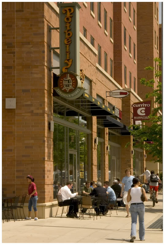
Photograph of Currito’s Clifton Heights location by Randy A. Simes for UrbanCincy.
The Eastern Corridor project, a multi-modal highway and commuter rail plan for eastern Hamilton County, is back in the news. Two weeks ago Cincinnati City Council voted against endorsing a TIGER II grant application seeking funds for the plan’s 17-mile commuter rail component.
The local media predictably turned this event into another city-county dispute, and insinuated that the TIGER II grant might alone fund construction of the entire Milford commuter rail line, which in 2003 was estimated to cost $420 million. There is no possibility of this happening, as Milford commuter rail would need to be awarded approximately two-thirds of the entire $600 million sum to be dispersed nationwide by the TIGER II program.
The media also ignored the Eastern Corridor plan’s central feature – four miles of the Milford commuter rail line is planned to be built parallel to a new $500 million U.S. 32 expressway between Red Bank Road and a point east of Newtown. The 1990’s cost estimate for Milford commuter rail included the savings associated with building a combined highway and rail project, including a new shared eight-lane bridge over the Little Miami River. The cost of building the commuter line first without provision for the future highway has not been studied.
The Oasis Line
Between downtown Cincinnati and the proposed eight-lane bridge over the Little Miami River, the Milford commuter rail is planned to operate on an eight-mile stretch of track paralleling the Ohio River known as the “Oasis Line.” In the late 1980’s the L&N Bridge (now the Purple People Bridge) was closed to freight rail traffic, and thus ended the operation of large trains along the Oasis Line. Since that time, traffic has been limited to a handful of freight cars per week, and the Cincinnati Dinner Train on weekends.
At first glance it would appear that implementation of commuter rail service on the Oasis Line should require nothing more than the purchase of commuter trains and the construction of a connection between the end of active tracks and the Riverfront Transit Center. Unfortunately, the poor condition of the existing track limits traffic to a maximum twelve miles per hour, meaning all eight miles between the Montgomery Inn Boathouse and Red Bank Road must be rebuilt. It is also probable that the Riverfront Transit Center connection must be built at least partially through Bicentennial Commons at Sawyer Point. All of this new track must be heavy freight railroad track, not the smaller and less expensive track used by light rail trains and modern streetcars.
Even after this needed investment in new track, grade crossings will remain at a half-dozen locations along Riverside Drive and in Columbia Tusculum, where perfunctory horn blasts will disturb those residing in new condos along Riverside Drive, longtime residents atop Mt. Adams and East Walnut Hills, and will surely be audible across the river in Bellevue and Dayton.
Poor Station Locations
Residents of Riverside Drive will be able to hear the Milford commuter rail trains, but most will not live within easy walking distance of the line’s stations. Of five stations proposed along the Oasis Line, only one, Delta Avenue in historic Columbia Tusculum, can be considered auspicious. By contrast, little existing ridership or future development exists around either the proposed Theodore Berry Park or the Cincinnati Waterworks (downhill from Torrence Parkway) stations. Ridership at the proposed Lunken Airport station will be minimal, and the Beechmont Avenue station will primarily serve as a bus transfer point.
On top of this minimal ridership, Riverside Drive is already served by Metro’s #28 bus. If Milford commuter rail is built, this bus will still have to operate due to the infrequent service and long distances between stations along the Oasis Line. It is also likely that Metro’s #28X, which serves Mariemont and Terrace Park en route to Milford, will have to continue operations as well.
An alternative proposal that called for streetcar or light rail service between downtown and Lunken Airport could eliminate the need for the #28 bus route, thus freeing up resources for bus service elsewhere. In this scenario significant savings would be achieved due to the considerably lower track costs for streetcars and light rail when compared to the freight railroad track currently proposed for the Milford commuter rail. Additionally, the vehicles are much quieter because they are electrically powered, labor costs are halved because they require just one driver, and more stops could be placed at much closer intervals.
High Operations Costs
No funding source has been identified to cover the outrageous annual operating costs for Milford commuter rail. In 2004 its annual operations were estimated to be $18.9 million — a sum similar to the estimated annual operating cost of the proposed 250-mile 3C Corridor passenger rail service between Cincinnati, Columbus, and Cleveland.
The cause of these exorbitant operating costs is an alarming combination of mediocre ridership and high labor costs. A 2002 report projected approximately 6,000 weekday trips (3,000 commuters) along the Oasis Line at full build-out. For comparison, this ridership figure is roughly equivalent to Metro’s most popular bus routes. At the same time, the FTA requires a crew of two onboard all diesel commuter trains that operate on freight tracks, even for the small Diesel Multiple Units (DMUs) planned for the Eastern Corridor, due to safety regulations.
By comparison, the Cincinnati Streetcar as presently planned will cost approximately $128 million to construct, require $3 million per year to operate, and will attract similar or higher daily ridership with 15 fewer route miles of track. Last month, city officials were notified that the Cincinnati Streetcar was awarded a $25 million Urban Circulator grant. If an identical amount were hypothetically awarded to the Eastern Corridor project through TIGER II, it would cover so little of the much more expensive Milford commuter rail that no construction would even be able to take place. Meanwhile, an additional $25 million put towards the Cincinnati Streetcar could extend the line into Avondale or Walnut Hills immediately. This means a potential grant for the Milford commuter rail might sit in the county treasury for a decade or more, or through tricky accounting be integrated into the Eastern Corridor project’s highway funding.
The Wasson Line
An alternative rail route to eastern Hamilton County involves use of the Wasson Line, which joins the Oasis Line near Red Bank Road but travels a very different path between that point and downtown Cincinnati. This route is eight miles – the exact same distance as the Oasis Line – but promises much higher ridership and much lower operational costs.
Since all freight operations ceased on the Wasson Line in 2009, electric light rail vehicles staffed by a single driver can be used at considerable cost savings over diesel commuter trains needed on the Oasis Line. Proposed station locations at Xavier University, Montgomery Road, Edwards Road, and Paxton Avenue each promise higher initial ridership — in 2002 the Wasson Line was estimated to attract 20,000 daily riders, or triple that of Milford commuter rail.
Also different from the Oasis Line, redevelopment potential exists around all of the stations locations along the Wasson Line, but especially the 25-acre parallelogram-shaped parcel recently assembled by Xavier University between its campus and Montgomery Road. The abandoned Wasson Road Railroad bisects this property and converges with the similarly abandoned CL&N railroad at the present edge of Xavier’s campus. The particular junction played a major role in the 2002 MetroMoves regional rail plan due to the convergence of several regional lines on their way into downtown along shared Gilbert Avenue tracks.
The Edward Road station is another location superior to anything on the Oasis Line. It is located within walking distance of Hyde Park Square and the majority of the neighborhood’s population. The station would be placed adjacent to, or across the street from, Rookwood Commons shopping center, and just a three-minute walk from the undeveloped Rookwood Exchange site north of Edmondson Road.
The Wasson Line has decisive cost-benefit advantages over the Oasis Line, but it obviously cannot function without a connection between Xavier University and downtown. After completion of the Cincinnati Streetcar, construction of a light rail connection between these points should be a top priority. This section alone promises the highest per-mile transit ridership in the metro area, and reaching Xavier University allows construction of three light rail branches, on existing railroad right-of-way, as funds permit.
Regional Priorities
It is unclear why construction of the Eastern Corridor project is any kind of priority. Much of the expense will be borne by Hamilton County, but with parts of the highway and rail line traveling over the undevelopable Little Miami River flood plain, the new expressway and perhaps even the rail line will act to encourage sprawl in Clermont County. Even the terminal station for the Milford commuter rail will not be in Milford’s town center, where it would be within walking distance of several hundred residents, but rather two miles away at Milford Parkway, home to Wal-Mart, Target, and chain sports bars.
Anti-rail forces are fond of saying that rail advocates will support anything that runs on rails. But advocates of better public transportation know that funds for rail projects are scarce and must be applied where the best cost-benefit exists. Moreover, the best transit mode must be chosen for each route. In the case of inner-city rail to Cincinnati’s eastern suburbs, diesel commuter rail along the Oasis Line is not the best solution, but rather, light rail service along the Wasson Line is.
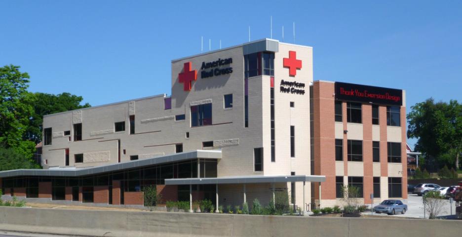
Designed by Cincinnati-based emersionDESIGN, the new 45,000 square-foot facility includes a variety of sustainable features like low-flow water fixtures that reduce water consumption by 40 percent, high-efficiency glazing and well-insulated wall cavities, bike racks and showers to promote eco-friendly transportation, sensor lighting and controls to reduce energy use. Outside the structure developer Neyer Properties included bioswale and rain garden systems to decrease impact on the storm water system, use of native landscaping to reduce irrigation, LED parking lot lights, an energy recovery ventilation, and a green roof.
In addition to the building features, the development team used more than 30 percent recycled material on the project, 40 percent regional materials, used woods certified by the Forest Stewardship Council, and recycled over 75 percent of construction debris from the site. The team expects to hear back on their Leadership in Energy & Environmental Design (LEED) application by the end of 2010, but it is widely expected that the structure will achieve LEED-Gold certification.
“As the design developed, it became apparent to us that we could move up in LEED rankings,” said Charlie Pond, Building Development Director, Neyer Properties. “It was a joint goal between Neyer Properties and the Red Cross to create a sustainable building, and we were emphatic about being environmentally friendly.”
The green roof incorporated into the building’s design covers approximately 25 percent of the total roof area. The sedum plants covering the roof area minimize the need for heating and air conditioning by reducing the amount of heat the building absorbs in summer and conserving building heat in winter.
Officials with the Red Cross believe the structure has approximately a 50-year lifespan for their purposes. The sustainable design features, meanwhile, are expected to have less than a five-year payback period through annual energy savings of 30 to 35 percent, meaning big savings for the non-profit.
“It’s great to work with emersion because of their large number of LEED Accredited Professionals. They are very familiar with green projects and they have similar goals as us,” Pond concluded. “We feel that developing sustainable projects the right thing to do, and we want to get Cincinnati caught up-to-speed on the green building movement.”