Categories
Business Development News

Gentrification Occurring in More Than Cincinnati’s Center City Neighborhoods

Like many cities across the United States, the City of Cincinnati is gentrifying, but it is doing so at a faster rate than most of its Midwestern peers – ranking fourth only behind Chicago, Minneapolis and St. Louis. When compared with the primary city in each of the nation’s 55 most populated metropolitan areas, Cincinnati is in the middle of the pack. Those cities that are gentrifying most quickly are located in the Northeast and along the West Coast.

The information comes from a new report published by the Federal Reserve Bank of Cleveland, which also dove into the financial implications of what is often generally considered a bad thing.

Gentrification is generally understood as the rise of home prices or rents in a particular neighborhood. In Cincinnati this has most vigorously been discussed as it relates to the transformation in Over-the-Rhine from what was one of the city’s poorest neighborhoods, to now being one of its trendiest.

Clifton Heights
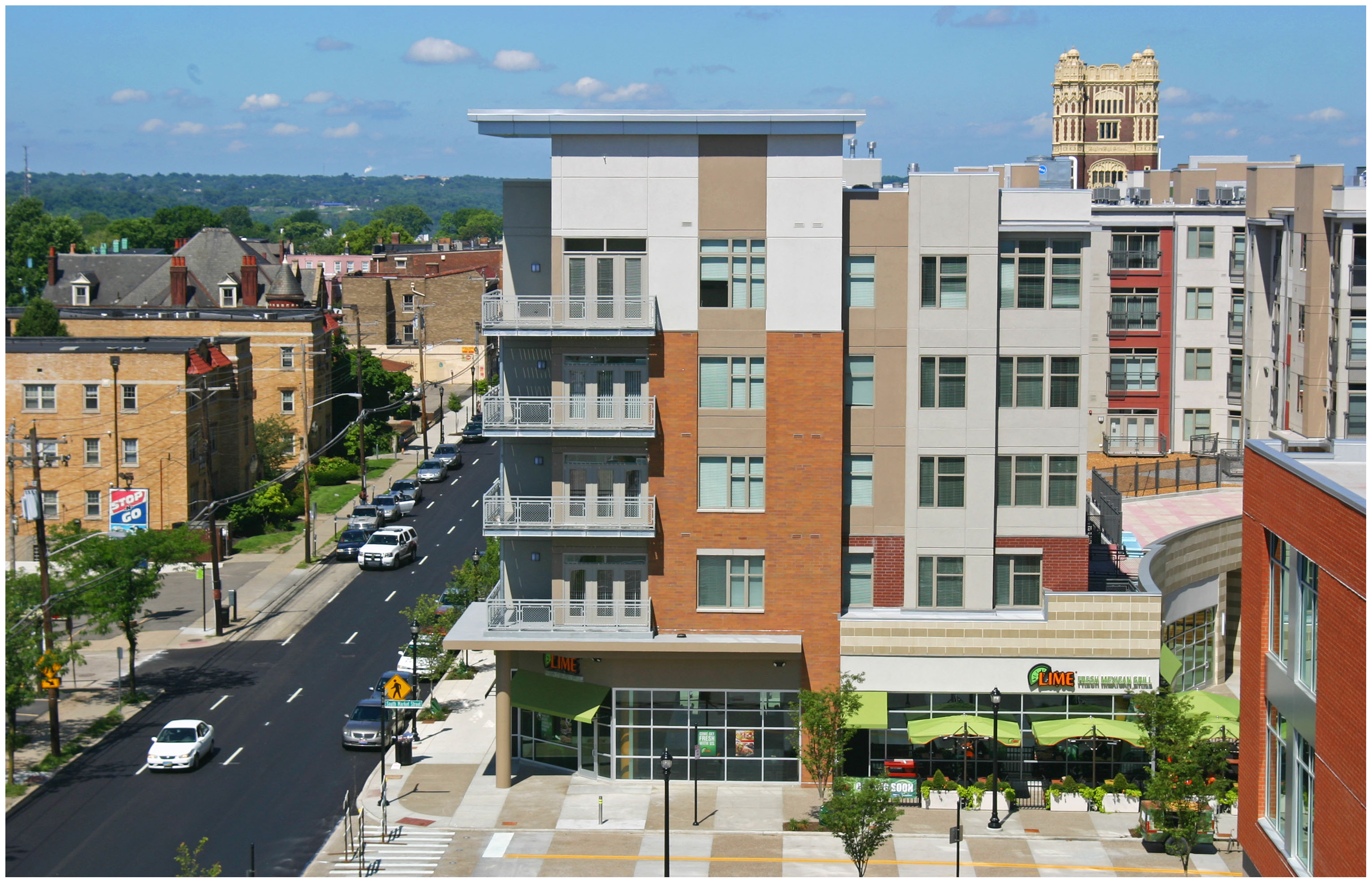
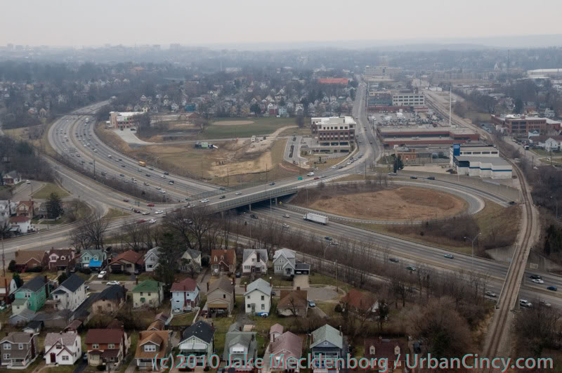
The Clifton Heights neighborhood, which continues to see a surge of private real estate investment, was found to be one of several Cincinnati neighborhoods that gentrified between 2000 and 2007. Photograph by Randy Simes for UrbanCincy.

“Gentrification is sometimes viewed as a bad thing. People claim that it is detrimental to the original residents of the gentrifying neighborhood,” stated Daniel Hartley, a research economist focusing on urban and regional economics and labor economics for the Federal Reserve Bank of Cleveland. “However, a look at the data suggests that gentrification is actually beneficial to the financial health of the original residents.”

What Hartley’s research found is that credit scores for those living in a neighborhood that gentrified between 2000 and 2007 were about eight points higher than those people living in a low-price neighborhood that did not gentrify. He also discovered that delinquency rates, as represented by a share of people with an account 90 or more days past due, fell by two points in gentrifying neighborhoods relative to other low-price neighborhoods during the same period.

Some, however, caution against drawing conclusions about the data presented in Hartley’s report.

“I don’t see any reason why gentrification would affect the credit scores of existing residents – those who lived in the neighborhood prior to gentrification occurring,” commented Dr. David Varady, a professor specializing in housing policy at the University of Cincinnati’s School of Planning. “It was my impression that banks and other financial institutions were not supposed to take the neighborhood into account but rely on the family’s financial characteristics.”

The practice Dr. Varady describes of banks and financial institutions taking neighborhoods into account is called redlining. It is a practice that was rebuffed by the Fair Housing Act of 1968 and the Community Reinvestment Act of 1977, but some believe the practice persists in more abstract forms today.

One of the biggest concerns shared by those worried about the gentrification of neighborhoods is that it is particularly those that rent, rather than own, who are affected most. This too, however, is challenged by Hartley’s research.

“Mortgage-holding residents are associated with about the same increase in credit scores in gentrifying neighborhoods as non-mortgage-holding residents,” Hartley explained. “This result suggests that renters in gentrifying neighborhoods benefit by about the same degree as homeowners.”

Cincinnati Gentrification (2000-2007)
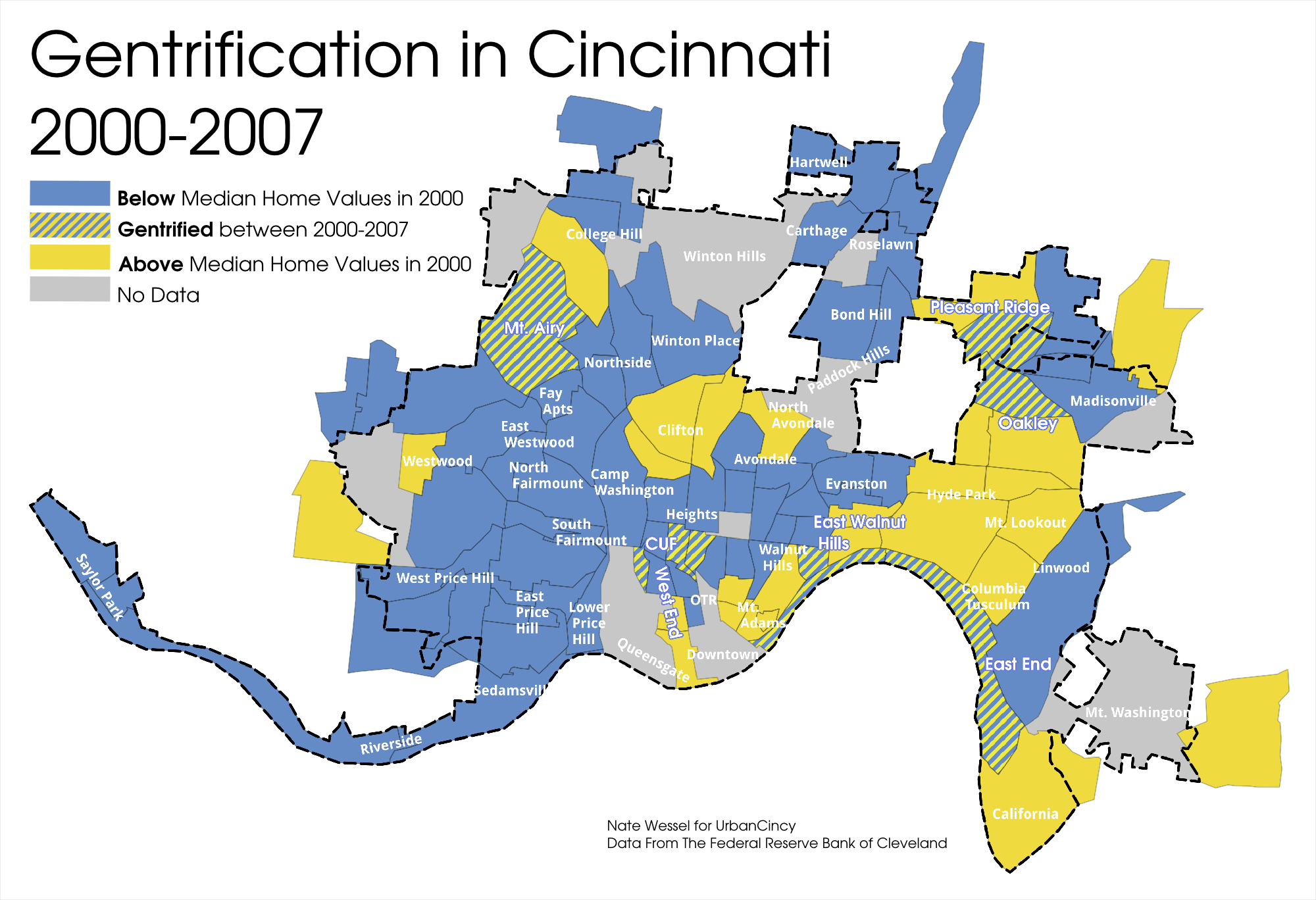
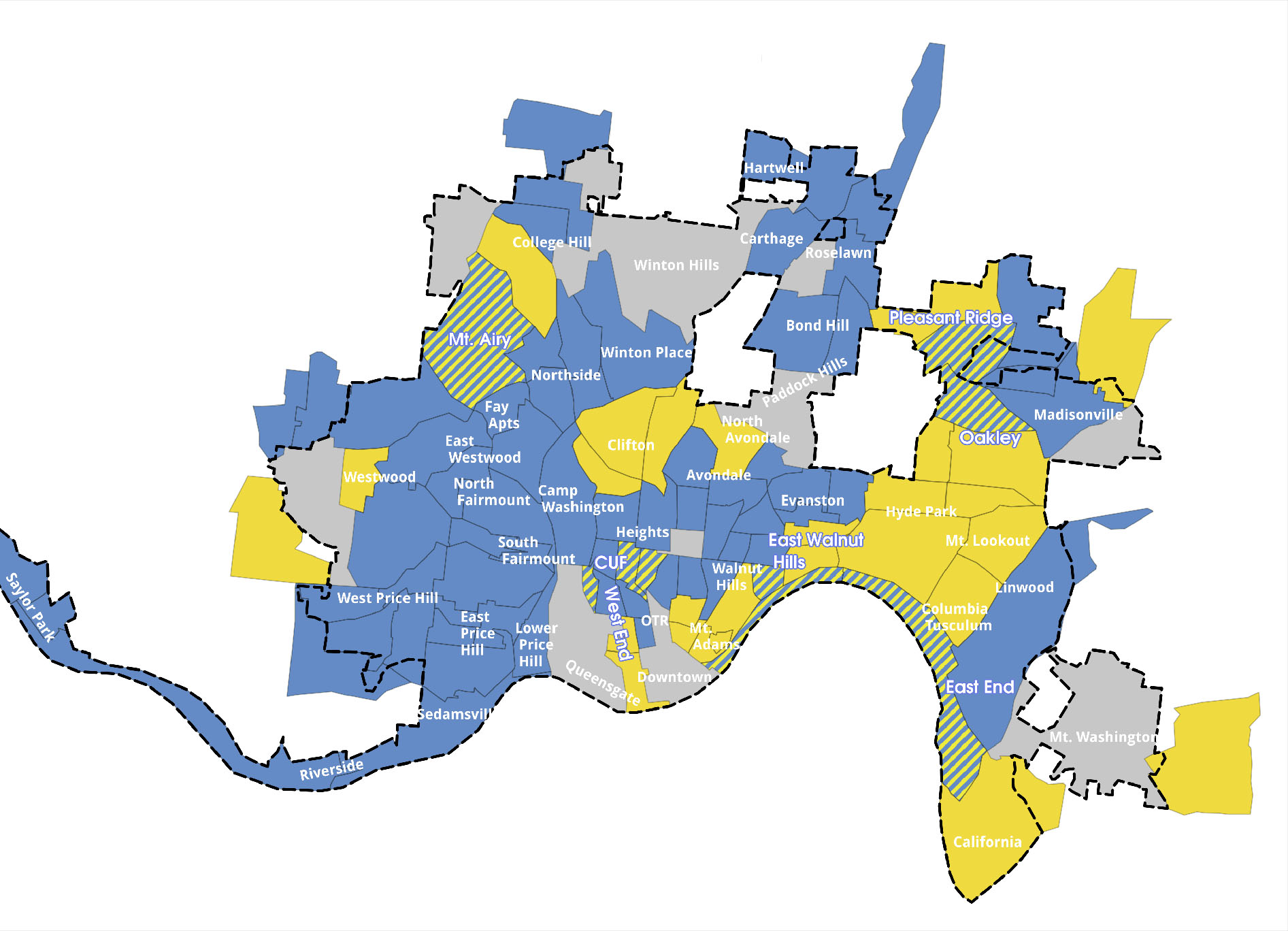
The Federal Reserve Bank of Cleveland noted gentrification in a wide variety of Cincinnati neighborhoods between 2000 and 2007. Map produced by Nate Wessel for UrbanCincy.

What is even more intriguing about the report’s findings is that original residents who moved from the gentrifying neighborhood, who many would consider displaced residents, experienced a 1.5 point higher credit score improvement than those who did not move.

The Federal Reserve Bank of Cleveland provided UrbanCincy with the data broken out by Census tract for Cincinnati. Approximately 72% of the city’s 104 Census tracts are defined as low-price, and of those 75 Census tracts with home valuation data, nine were found to have gentrified between 2000 and 2007.

When examined more closely it becomes clear that the neighborhoods experiencing the biggest gains in home value and income in Cincinnati are those that are in the center city. Specifically, and perhaps not surprisingly, five of the nine are located in the neighborhoods of Clifton Heights, East Walnut Hills, Fairview, University Heights and the East End. Outside of the center city, Pleasant Ridge, Oakley, Columbia Tusculum and Mt. Airy also experienced gentrification over the past decade.

Community council leaders for these neighborhoods did not respond to multiple requests for comments from UrbanCincy.

Unfortunately, the two neighborhoods where many expect gentrification has occurred most – Downtown and Over-the-Rhine – did not have median home value data available for the Federal Reserve Bank of Cleveland to study.

While the report has generally positive findings about the impacts of gentrification, Cincinnati is at a disadvantage when it comes to improving the financial health of its neighborhoods.

According to the report, the percentage of low-price Census tracts in Cincinnati beneath the median home value of the metropolitan area is 14 percentage points higher than the national average, and the rate at which Census tracts are gentrifying in the Great Lakes region is approximately 4.5 points lower than the national average.

“I don’t have a clue what Hartley meant by the phrase ‘neighborhoods with a potential for gentrification’ but the assertion that 95% do in Baltimore is rather ludicrous given the high rate of abandonment,” Dr. Varady scoffed. “Baltimore certainly can use more gentrification but how the city can promote this is an open question.”

With the nine identified neighborhoods in Cincinnati spread throughout a mix of expected and unexpected locations, it is probably safe to say that the Census tracts in Downtown and Over-the-Rhine also gentrified during this period, or have since 2007.

Change in cities is inevitable, but whether these changes sweeping Cincinnati are good, bad or indifferent is probably still open for spirited discussion among those most interested.

“In general I think that gentrification presents benefits and costs,” Dr. Varady concluded. “Anyone who says it is all bad or all good is not contributing to the debate.”

This story originally appeared in the December 20, 2013 print edition of the Cincinnati Business Courier. You can view that story online for additional comments and discussion. UrbanCincy readers can take advantage of an exclusive premium digital Business Courier subscription that includes access via the web, smart phone or tablet applications for just $49 per year.

Categories
News Transportation

VIDEO: Biking from Cincinnati’s Fountain Square to the Ohio Statehouse in Columbus

In September 2009, UrbanCincy’s Jake Mecklenborg biked from Cincinnati’s Fountain Square to the Ohio Statehouse in Columbus.

The ride documents the state of bike paths, or stretches of roadway, between the two cities. The approximate 125-mile journey relies heavily on the Little Miami Scenic Trail. But as Jake experienced, the usage of the trail drops off significantly once you get out of the city.

Another issue experienced during the ride was the lack of trail or dedicated bike facilities heading into Columbus.

One of the other trails that Jake partially uses on the trip is the Ohio River Trail, which is still under development. Officials with the City of Cincinnati continue to make progress on new segments of that trail, but it is still a ways off from its completion of connecting the Little Miami Scenic Trail with Smale Riverfront Park in downtown Cincinnati. Future extensions of the trail would bring it even further west along Cincinnati’s waterfront.

The City of Cincinnati is also studying a new dedicated bike lane along Delta Avenue that would lead to the Ohio River Trail. Those that are interested in weighing in on that project can do so by voting for your preferred design option online.

Categories
Business News Politics

Cincinnati Expands, Streamlines Mobile Food Vending Zone Program

Last month Cincinnati City Council approved changes to the city’s Mobile Food Vending Program, which oversees food truck operators choosing to take advantage of mobile food vending zones throughout the city.

According to city officials, two new mobile food vending zones will be added in Over-the-Rhine. The changes were approved 8-1 by city council, with Councilmember Christopher Smitherman (I) casting the lone opposition vote.

The first is at Washington Park and will accommodate up to three food trucks at any given time. This location, officials say, will be open to mobile food vendors from 6am to 3pm, and will be open during evening hours based on agreements between the Cincinnati Center City Development Corporation (3CDC) and those vendors who are in the program.

Cincinnati Food Truck at Court Street

The second Over-the-Rhine location will be at Twelfth and Clay Streets, and is the result of much negotiation with nearby restaurants that had been wary of a mobile food vending zone near their establishments. This location will accommodate up to two food trucks at a time, and unlike the Washington Park zone, will allow vendors to operate between 6pm and 3:30am.

The new Over-the-Rhine mobile food vending zones add to the other six locations in place throughout the city. According to Councilmember Laure Quinlivan (D), who first proposed legislation to create the mobile food vending program in 2010, those who would like to see mobile food vending zones established elsewhere throughout the city can contact her office at laure.quinlivan@cincinnati-oh.gov.

City officials say that all of the following official mobile food vending zones are open seven days a week, and are available to operators with mobile food vending licenses on a first come, first serve basis.

  • 12th/Clay Streets (6pm to 3:30am)
  • Court Street Market (6am -3pm)
  • Fountain Square/North Vine Street (6pm-3:30am)
  • Fountain Square/North Fifth Street (6am to 3:30am)
  • Fountain Square/South Fifth Street (6am to 3:30am)
  • Purple People Bridge (6am to 3:30am)
  • University Hospital (6am to 3:30am)
  • Washington Park zone (6am to 3pm)

“If you have additional mobile food vending zones you’d like to see created, please contact me to learn how to get it done,” Quinlivan stated. “The bottom line is that you need to get support for the new zone from nearby property owners.”

Cincinnati Food Truck Zones

Food truck operators interested in getting a mobile food vending license will not see their annual fees change from the current $600 for a six-month license or $1,000 for a full year. But, according to city officials, they will now apply through the Cincinnati Health Department in an effort to streamline the application and licensing process since the health department also must issue a health license for the food trucks.

Other approved changes include the elimination of the non-refundable $25 application fee, and structural changes for the mobile food vendor zone at the foot of the Purple People Bridge to allow for more consistent space availability for food truck operators.

Due to the court-issued restraining order on the City of Cincinnati, the changes could not take effect immediately, and will finally go into effect this Friday, May 17 following the required 30-day waiting period.

To celebrate, the Cincinnati Food Truck Association, Quinlivan and community leaders will gather at Washington Park this Friday at 11:30am to celebrate the new food truck zones.

“I’m excited our program has created jobs and livened up city streets,” Quinlivan stated. “I’m told we now have 28 mobile food trucks in Cincinnati and we hope all of them participate in our program.”

Categories
News Opinion Politics Transportation

EDITORIAL: Cincinnati Leaders Should Rethink Planned Rail, Trail Systems

Ten days ago UrbanCincy sounded the alarm on the proposed Wasson Way Trail, and we feel that due to the large amount of feedback that further explanation is needed.

Tomorrow at 12pm, City Council’s Strategic Growth Committee will discuss the proposal that would turn the Wasson Corridor from a railroad right-of-way into a recreational trail. What UrbanCincy is urging City Council to require is a minimum of 28 feet worth of right-of-way preserved for future light rail use.

Standard designs for bi-directional light rail traffic require a minimum of 28 feet of right-of-way. Along some portions of the Wasson Corridor it may very well be possible to accommodate 28 feet for light rail, plus additional right-of-way for the proposed recreational trail, and in those segments it may make sense to get started.


Looking east as the Wasson Line crosses over Interstate 71. Photograph by Jake Mecklenborg for UrbanCincy.

While there is no funding currently in place to build light rail along the Wasson Corridor, it would be short-sighted to remove one of the best rail transit corridors in the city. This was previously done on Cincinnati’s west side when an abandoned railway used by freight and passenger rail traffic was abandoned and then allowed to be built over and occupied by the Glenway Crossings retail center.

Allowing this to take place offered city and county leaders to reap the rewards of a short-term boost, but it has also created a situation that makes building light rail to Cincinnati’s western suburbs almost impossible. This same thing could happen to Cincinnati’s eastern suburbs should the Wasson Corridor be used by a recreational trail.

Proponents of the Wasson Way Trail project made it clear that many of the supporters also want to see light rail eventually happen, but that we should not wait until that day comes to improve the visual appearance of the corridor. Case studies from all over the United States show, however, that once a former rail line is converted into another use, it is almost always an impossible political task to take that land back for rail purposes.


2002 regional light rail plan for Cincinnati.

In the larger scheme of things, UrbanCincy believes that regional leaders need to take a step back and ask themselves why we are still discussing commuter rail along the Ohio River, and a recreational trail through densely populated city neighborhoods. The priorities should be reversed, and the Oasis Line along the Ohio River should be converted into a recreational trail while the Wasson Line is preserved for future light rail use.

It is estimated that the Wasson Light Rail Line would attract three times the number of riders than the Oasis Commuter Rail Line, while also being significantly less expensive to build and operate. Futhermore, when discussions were held about the Oasis Line, residents and property owners along the line voiced their opposition to such activity and have conversely expressed interest in seeing the railway converted into a recreational trail.

City and regional leaders should maintain the natural beauty of the Ohio River and turn the Oasis Line into an attractive recreational trail that can connect into existing trail networks to the east, and the Wasson Line should be preserved for light rail use in the future. It may seem frustrating to leave the Wasson Line in its current state of appearance, but it will be much more frustrating to jeopardize one of the best potential light rail corridors envisioned for the region.

Categories
News Transportation

Cincinnati wins national CDBG award for Ohio River Trail project

City leaders will gather today in downtown Cincinnati to accept a national award for its Ohio River Trail project. The John A. Sasso National Community Development Week Award will be presented at the National Community Development Association (NCDA) convention currently being held in Cincinnati.

NCDA officials say that the Ohio River Trail project is helping to improve neighborhoods and better the lives of low- and middle-income residents through the use of the association’s Community Development Block Grants (CDGB). In 2011, eight departments within the City of Cincinnati made more than $13 million in total CDBG requests. Over the past five years, the City has requested approximately $13 million annually in CDBG funds.

The association specifically looked at a 1.1-mile stretch of the Ohio River Trail through Columbia Tusculum which was recently completed thanks to a CDBG Economic Development Initiative grant of $745,125. In May, UrbanCincy partnered with the City of Cincinnati to give future bicycle commuters a tour of the Ohio River Trail.

Once entirely complete, the Ohio River Trail will connect with the Little Miami Scenic Trail to the east and downtown Cincinnati at its western terminus. Future segments could go further west along the Ohio River.

The Ohio River Trail project was chosen for this year’s award out of 550 local governments who work with NCDA on community development projects. Those projects include a wide variety of efforts that are targeted to improve economic development, housing and human services.

Officials will be presented the award by Cardell Cooper, executive director of NCDA, at 12:30pm today at the Pavilion Room inside the Hilton Netherland Plaza Hotel.