Categories
News Transportation

New Cincinnati Bike Map Aims to Change the Way New, Old Cyclists View the City

In 2011 Nate Wessel sought out to change the way Cincinnati mapped its transit. In a region with multiple transit operators that all use traditional bus mapping visuals, it was quite the daunting task. But after successfully raising more than $2,000 on Kickstarter, Wessel was able to fund his effort to print tens of thousands of his newly designed maps that ultimately received national praise.

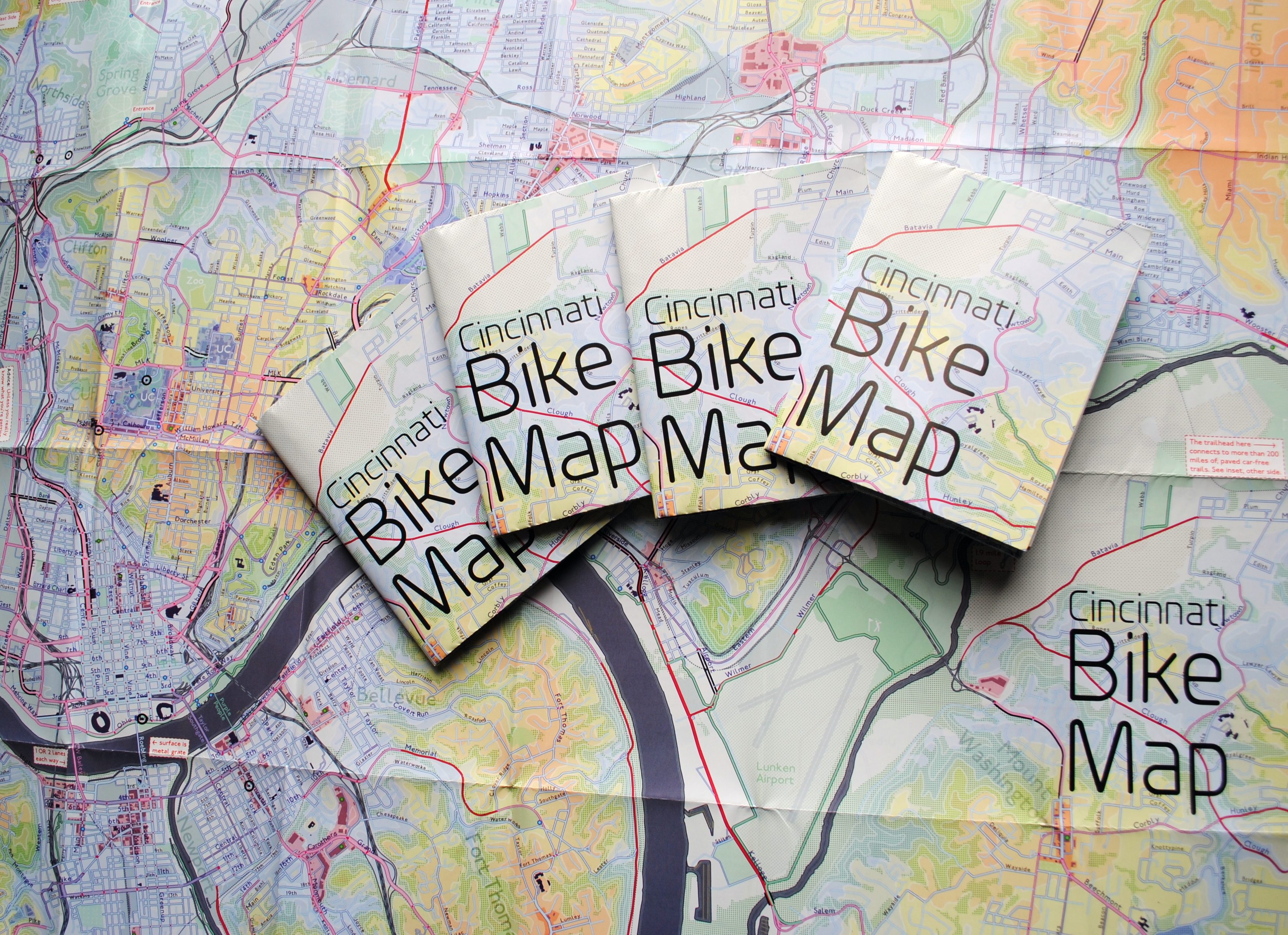
Since that time he has continued his quest to improve the visual nature of map-making in Cincinnati, including serving as UrbanCincy’s official contributing cartographer, but he also embarked on another major endeavor. Instead of a transit map with bus frequencies, Wessel this time focused his energies on creating a new regional bike network map.

“Imagine someone kept taking, and reproducing and sharing, very unflattering photos of you or someone you loved. If you’re like me, you’d probably let the first one slide,” Wessel stated. “Maybe it was an accident, but by the fifth or sixth one, you’d start noticing a pattern and you’d start getting kind of miffed about it.”

This is the feeling the twenty-something urban planner, cartographer and fashion designer felt about the region’s existing bike maps, and he wanted to take control of the situation and improve it.

“This is a subtle visual game and words won’t do,” Wessel explained. “You need to make your own photo that shows the beauty you see in what you love; and then get other people to see what you see.”

One of the ways to accomplish that, he says, is to get the maps into people’s hands – digital maps are not enough. While the physical presence of a printed map gives it a sense of permanency and seriousness, producing a hard copy map also comes with its challenges.

After finishing the design for the Cincinnati Bike Map, Wessel said that he received feedback from the binder recommending a redesign to better accommodate the way the paper would fold, but that it was too late in the process. As a result, he wishes the maps folded a bit better, but that he is otherwise quite pleased with the final product. Perhaps leading to that feeling of satisfaction, however, is the fact that no compromise was needed since the project was entirely self-funded.

“Both times I’ve raised money for these projects it was in advance of having a real demonstrable product,” said Wessel. “In neither project have I ever had to check anything with a sponsor, supervisor or co-designer. The maps were totally my own in both cases, held to my own standards alone and uncompromised. That is very unusual for print maps.”

While quite unusual, it was a situation he preferred. In fact, Wessel says that a local organization very generously offered to fully fund the printing of Cincinnati Bike Map should he work with their graphic designer. A generous offer indeed, but one that came with risks that the final product not turn out as originally envisioned.

The release of the new regional bike map last month comes at a time when Cincinnati is in the national spotlight for its dramatic gains in bike ridership and development of new bike infrastructure.

Now that the project is complete, the goal now shifts to distributing the stack of Cincinnati Bike Maps that now exist. In addition to distributing the maps to local bike shops and organizations, Wessel is also mailing out copies of the map. His hope is that new or unfamiliar riders feel empowered by the maps, and that experienced riders use them to explore new routes throughout the region.

“Regular cyclists have found their favorite routes and will probably stick with what they know,” said Wessel. “Though, I totally discovered Fort Thomas through this map. Every map I’d seen made it look like a pretty crappy, suburban place to ride and I always avoided it; but the streets are beautifully wooded and very slow with 25mph speed limits.

Of course, all of this would not have been possible without access to the treasure trove of data on-hand at Cincinnati City Hall, and with the OKI Regional Council of Governments.

Those who would like to get a free copy of the Cincinnati Bike Map can do so by emailing Nate Wessel at bike756@gmail.com and informing him of your name, how many copies you want, and the address to which he can ship them.

Categories
News Transportation

PHOTOS: Streetcar Maintenance Facility, OTR Track Work Nearing Completion

Construction of the Cincinnati Streetcar system has been moving quickly over the past several months. In the Central Business District, track work on Walnut Street has been completed between Central Parkway and Seventh Street, and two stations are under construction along this stretch.

Downtown drivers will soon get a break from track construction until next year, when crews will return to the CBD to finish the Walnut Street track after the holiday season.

In the mean time, crews have moved to the Northern Liberties to finish up the Over-the-Rhine portion of the system. The special track work in this area includes turnouts on Henry and Race streets, connecting to the Maintenance & Operations Facility, and turnouts to Findlay and Elder Streets, which will allow the Uptown Connector to be built in the future without disrupting service.

Crews recently finished resurfacing portions of Elm and Race streets along the route, which means that underground utility work has wrapped up. Many of the streetcar stops in Over-the-Rhine are also now complete and many of the new traffic signals have been activated.

While much has been accomplished, a significant amount of construction remains, including track work along Main and Second streets in the CBD. But anyone taking a walk down Race Street, in Over-the-Rhine, today should get a good impression of what the finished track and stations will look like.

EDITORIAL NOTE: All 14 photos were taken by Travis Estell for UrbanCincy between October 21 and November 1, 2014.

Categories
News Transportation

City Officials to Present Alternatives for Two-Way Street Conversions in Walnut Hills

City officials are moving forward with potential changes to E. McMillan Street and William Howard Taft Road in East Walnut Hills. The proposed changes are a continuation of other improvements that have been made in the area in recent years, and will be presented to the public at an open house meeting on Tuesday, November 18.

Developed by planners and engineers at Cincinnati’s Department of Transportation & Engineering (DOTE), the improvements being considered include two-way street conversions of E. McMillan Street and William Howard Taft Road between Victory Parkway and Woodburn Avenue, and Woodburn Avenue between E. McMillan Street and Taft Road.

The proposal is an extension of two other two-way street conversions that were completed in 2012.

According to community leaders, the projects are seen as an opportunity to better connect the business districts of Walnut Hills and East Walnut Hills.

“The two-way conversion would make the two neighborhoods much more connected and make the distance between DeSales Corner and Peeble’s Corner more walkable,” explained Kevin Wright, Executive Director of Walnut Hills Redevelopment Foundation. “Our goal is to make the two districts more connected. Imagine grabbing a pizza at Fireside and then walking down to Myrtle’s Punch House, with a stop at Brewhouse along the way.”

The idea of converting one-way streets to two-way travel is one that has been gaining traction nationwide amongst residents and business owners looking to slow traffic and improve access within their communities.

While former Cincinnati Vice Mayor Roxanne Qualls (D) had pushed for the conversion of the one-way streets in Walnut Hills to two-way travel, there have also been a number of other conversions throughout Over-the-Rhine in recent years, including the ongoing effort to transition Main Street back to two-way traffic.

City planners, however, say that the two-way street conversions are not the only improvements being proposed. Other components include the typical streetscape enhancements, as well as some gateway features for the neighborhood business districts. All of the proposed changes, they say, are the result of recent conversations and feedback from neighborhood residents and stakeholders.

“The stretch of McMillan between Park Avenue and Woodburn, currently, is very auto centric,” Wright conceded. “Our hope is that this is one of many changes that will be put in place over the next few years to make that area more walkable.”

Greg Koehler, Senior Economic Development Analyst at Cincinnati’s Department of Trade & Development, says that the open house will be held at the Keller Student Center at St. Ursula Academy. The event will run from 5:30pm to 7:30pm. Official presentations will be made at 5:45pm and 6:45pm, but City staff will be on-hand throughout the entire meeting to answer any questions regarding the plans.

City officials were unable to provide UrbanCincy with the drawings of the proposed changes ahead of the meeting. Those interested in reviewing the detailed plans are encouraged to attend the open house scheduled for Tuesday, November 18. The meeting location is highly accessible via Metro bus service, and free bike parking is located at the school.

Categories
Arts & Entertainment News

Take a Look at These 20 Breathtaking Photos of Cincinnati’s Center City

Many of you who read UrbanCincy get to see and experience the center city on a regular basis, but others of you cannot. But for those of you that do, rarely do you get to take a bird’s eye view of the city.

Brian Spitzig, an occasional contributor to UrbanCincy, recently took a flight around the inner city to take what turned out to be some incredible aerial photography. He took hundreds of photos, but we went through them and selected some of the best to share with you.

This is the first part of what will be a two-part series. The following 20 photographs are all of Downtown and Over-the-Rhine, while the next part of this series will focus on neighborhoods outside of the greater downtown area.

If you like what you see here, you can follow Brian Spitzig on Instagram.

Categories
Development News

Latest Excavation Work at Smale Riverfront Park Creates Beach Along Ohio River

Great weather seems to always bring great news for construction projects, and this is the case in the latest project update for Cincinnati’s $120 million Smale Riverfront Park.

In the video, project manager Dave Prather points out that the structure enclosing Carol Ann’s Carousel now has its roof decking and framing in place, with the glass wall panels being readied for installation soon. Prather further showed where the elevator shaft has been completed and the large skylight that will form the roof of the building, thus allowing for a flood of natural light inside.

“Keep an eye on this side, it’s really gonna have a transformation” Prather noted. “But right now you can get a sense of how open the structure is.”

Since the last project update, the cascade water features and light fixtures are now in place at the Vine Street Fountain & Steps, which mirror the setup at the already complete Main Street Fountain & Steps. The area is now just awaiting the installation of its granite surface.

One of the more interesting elements of this project update is the excavation work at the river’s edge to make way for the Great Lawn. Now virtually complete, the excavation work as created a beach of sorts going directly into the Ohio River. The completion of this work has also opened up a variety of new views of the Roebling Suspension Bridge that were not previously visible.

Prather then discussed a wall that is now in place along the river bank where the riverwalk will continue from already completed portions of the sprawling park.

“We are now able to connect with the river in a way never had before,” Prather noted proudly.

All components of the current phase of construction work are still anticipated to be completed in late spring or early summer ahead of the 2015 MLB All-Star Game to be held at Great American Ball Park.