Categories
News Transportation

Ohio Maintains Position As Nation’s 16th Best State for Bicyclists

Bicycle Friendly State Ranking 2015
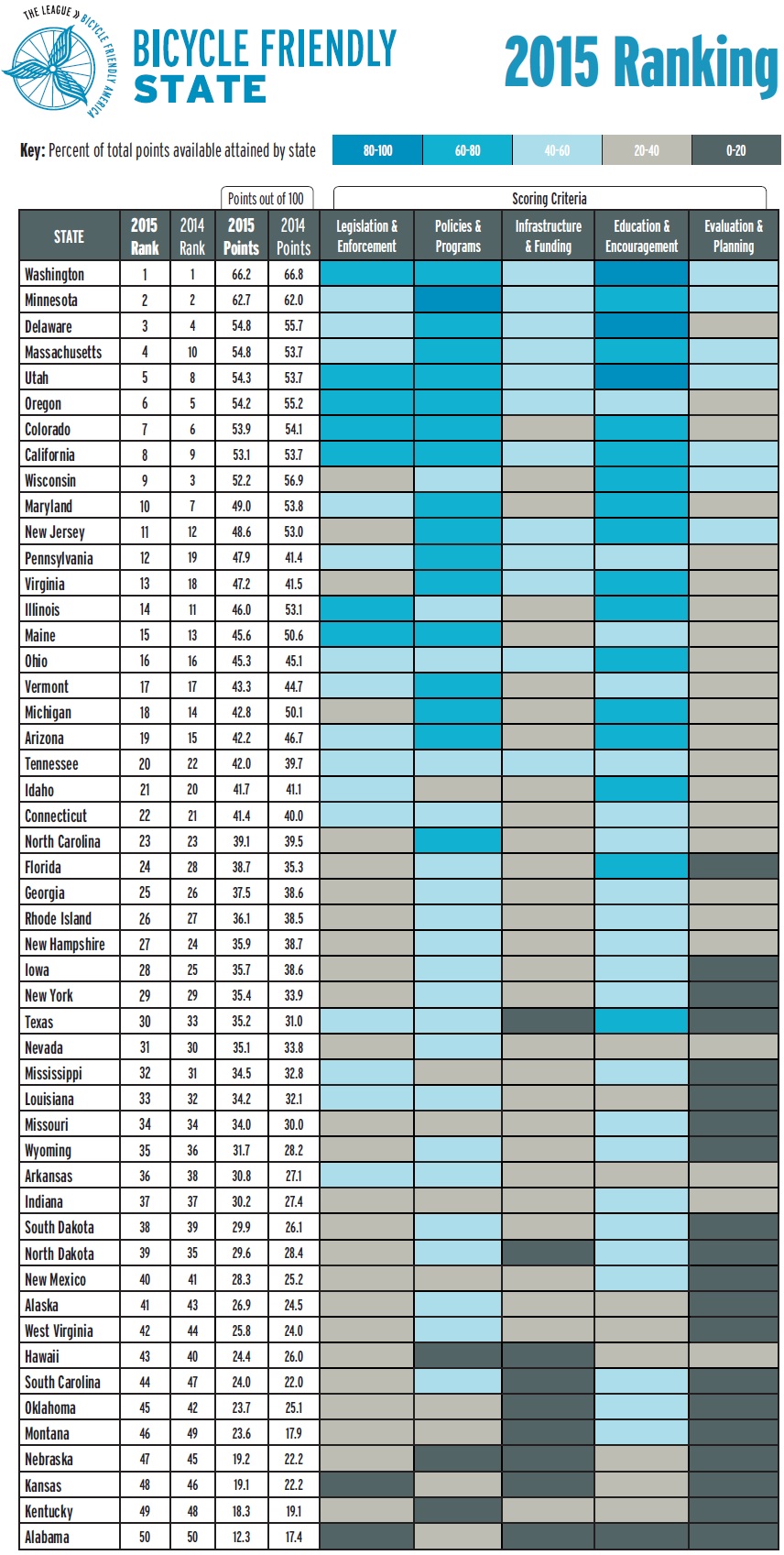
Ohio has maintained its ranking as the 16th best state for bicycling in 2015, according to the League of American Bicyclists. The Buckeye state was previously ranked 16th in 2014, after a big jump from 32nd the previous year. This position places the state as the fourth best in the Midwest, behind just Minnesota, Wisconsin and Illinois.

The ranking is issued after compiling the results of a Bicycle Friendly State questionnaire that is answered by a coordinator in each state, and is based on five criteria: Legislation and Enforcement, Policies and Programs, Infrastructure and Funding, Education and Encouragement, and Evaluation and Planning.

The state scored a total of 45.3 points out of a possible 100, and fared best in terms of its Education and Outreach, but scored lowest in its Evaluation and Planning.

“I’m excited about where Ohio is,” Frank Henson, President of Queen City Bike, told UrbanCincy. He said that he felt that even though Ohio gained in its scoring of points, the reason it did not move higher in the ranking is due to the investments being made elsewhere around the country.

“While Ohio continued to do a lot of great things, especially here in Cincinnati and neighboring communities, other states were ramping up,” Henson said.

Leadership at Queen City Bike believes that Ohio has the potential to move up in next year’s ranking with the possible passage of House Bill 154.

Chuck Smith, Chairman of the Ohio Bicycle Federation, agreed and said that the top two suggestions from the League of American Bicyclists to improve the state’s ranking are both addressed in the bill. The first is a statewide requirement for vehicles to provide three feet of clearance when passing bikes, which is already an ordinance in Cincinnati. The second is a “dead red” law, which would allow all vehicles, including bicycles, to proceed through an intersection if they are not detected by traffic control devices.

“It’s important for cyclists to be legal, but bikes are sometimes outside of the system” Smith said in reference to many traffic control devices that are unable to detect the presence of people riding bikes.

One of the other major items recommended by the League of American Bicyclists is the adoption of a statewide Complete Streets policy – something both state and local officials continue to struggle with all over Ohio.

Julie Walcoff, Bicycle and Pedestrian Program Manager of the Ohio Department of Transportation, said there are several other actions being taken at the state level that could further bolster the state’s national ranking.

“We’re putting together a safety coalition that will encompass advocates, communities around the state, and other organizations that are interested in bicycle and pedestrian safety,” Walcoff told UrbanCincy. “We’ll be using that group to help develop a statewide educational campaign that focuses on road users of all types and on law enforcement.”

In addition, ODOT recently kicked off an initiative to designate proposed US and state bike routes throughout the Ohio, connecting the 17 largest cities in the state. ODOT officials say that these routes will use roads that already have an acceptable level of safety, along with existing paths.

While many have described ODOT as an agency almost entirely focused on highway building, Walcoff says they pride themselves on their working relationships with bicycle advocacy organizations throughout the state. This, she says, can help not only maintain Ohio’s current ranking but help it get even better in the future.

In Columbus, advocacy group Yay Bikes! is working with the city to increase the focus on design and engineering of the street infrastructure. Executive Director Catherine Girves says that to help improve the current situation, they are having engineers budget time each week to ride the streets with their group in order to better understand the needs of those people riding bikes.

Back in Cincinnati, Henson noted the addition of Cincy Red Bike and the Central Parkway protected bike lane – the first of its kind in Ohio – as two key developments over the past year that have helped state’s ranking. Following the Cincinnati’s lead, both Cleveland and Columbus are now planning protected bike lanes of their own.

While much of the focus has been on core cities, Queen City Bike is also working with the Connecting Active Communities Coalition, which is comprised of representatives from nine communities in Cincinnati’s northern suburbs: Blue Ash, Evendale, Glendale, Lockland, Montgomery, Reading, Sharonville, Woodlawn and Wyoming. As of now, this group is working to develop a coordinated network for bicycling and other non-motorized modes of transportation on a multi-jurisdictional level.

Kentucky, meanwhile, ranked as the second worst state in the nation with just 18.3 points. This represented a 0.8 point drop from the previous year.

Categories
Arts & Entertainment News

EXCLUSIVE: 43 Photos From the 64th Annual DAAPworks Fashion Show

The University of Cincinnati hosted its 64th annual DAAPworks Fashion Show on Friday, May 1. As in the past, organizers of the fashion show provided UrbanCincy with up-close access in order to photograph one of the biggest events in the city each spring.

As its name suggests, the fashion show corresponds with the larger, week-long DAAPworks exhibition that showcases the final work produced by graduating students from the University of Cincinnati’s top-ranked College of Design, Architecture, Art and Planning. Each year the event draws thousands to view the work, including recruiters and businesses from across the nation.

The DAAP Fashion Show, which is sponsored by Macy’s, is typically the biggest draw and serves as the capstone event for the showcase. The event is regularly a sold-out affair, and is, perhaps fittingly, hosted inside UC’s architecturally acclaimed, Thom Mayne-designed Campus Recreation Center.

The show is a way for the fashion design students, which are required to engage in professional fashion design work prior to graduating, to both showcase their final designs, as well as market themselves to potential buyers and employers in attendance.

EDITORIAL NOTE: All 43 photographs were taken by Jack Mecklenborg on May 1, 2015. Those interested in purchasing or using any of these photos may contact editors@urbancincy.com for more information.

Categories
Development News

Project Officials Ready to Move Forward With Next Phase of The Banks

Officials overseeing the development of The Banks have announced that they will soon proceed with the design and construction of the infrastructure needed for the next phase of the massive riverfront project.

Yesterday, at a special meeting of The Banks Steering Committee, the eight-member group unanimously voted in favor of moving forward with what they expect to be $29.3 million worth of work, which would then provide the platform for millions more in private investment in the form of offices, residences and retail on what is referred to as Lot 24.

As has been the case with all prior phases of the mixed-use development, the City of Cincinnati and Hamilton County will build out the utilities and roadway network, and construct a 690-space, two-level parking garage that will lift the site out of the Ohio River floodplain. Carter and The Dawson Company – the private development team selected for the project – would consider what elements should be included and then proceed with building and leasing out whatever is built on top of the parking decks.

A guiding principle that has not changed since the beginning of the development process is that the underground parking garage will be reserved for public parking, leaving Carter-Dawson to develop additional above-ground parking to satisfy the City’s mandatory parking requirements.

The Steering Committee said that the public work will be funded through the issuance of $22 million in tax increment finance bonds, and $7 million from the State of Ohio. Project officials say issuance of the bonds is expected to come within the coming months.

While the Carter-Dawson team has not yet decided the exact mix for this third phase of work, it is widely expected to be primarily residential. In total, the zoning and infrastructure for the site will allow for around 320,000 to 400,000 square feet of developable space.

The timing of the announcement could not be better, with work rapidly progressing on General Electric’s 338,000-square-foot Global Operations Center, 19,000 square feet of retail space, and the 291 apartments at the phase two site to the immediate north; and with the announcement that AC Hotels will develop the long-sought hotel along Main Street in front of Great American Ball Park.

Phase two work is expected to be completed in phases throughout 2016, while AC Hotel by Marriott is expected to open in spring 2017.

While management with the Cincinnati Bengals expressed some concern over the loss of one of the team’s few remaining tailgating lots, The Banks itself is evolving into more of an entertainment district than many had thought.

In April, state officials approved a new open-container district law that will soon be in place at The Banks; and yesterday, in a separate move, the Cincinnati Reds applied for a zoning variance to allow for the installation of a video board that will overlook Freedom Way – providing live video programming when the surrounding streets are shut down to cars for special events. Such moves could render tailgating lots obsolete as fans move to the streets on game days.

Project officials say the phasing of construction at the 18-acre site has been carefully coordinated between the district’s various stakeholders, along with the construction schedule of Smale Riverfront Park. As park work has moved west so has work at The Banks, and with the latest work on the park taking place just south of phase three of The Banks, the timing makes perfect sense.

If all goes according to plan, this next phase of infrastructure work could begin as soon as January or February – just after the conclusion of the Bengals football season.

Categories
Arts & Entertainment News

Walking tour to give historical perspective on Cincinnati’s urban core

maxresdefaultMax Grinnell is an author, historian, and a professor who is experienced at sharing unique perspectives of American cities. He has given a number of talks and led walking tours in cities across the country, focused on urban innovation, public art, and travel. Next week, he will be coming to Cincinnati to give us a look at the city from a historical perspective.

Grinnell’s tour will be based on Cincinnati: A Guide to the Queen City and Its Neighbors, a book published in 1943 for the Federal Writers’ Project. It is a part of the American Guide Series, also known as the WPA guides, a program funded by the New Deal to employ writers during the Great Depression. Today, it serves as a snapshot of 1943 Cincinnati, when the city’s population was 455,610 and now-iconic structures like Carew Tower and Union Terminal were just a decade old.

UrbanCincy was able to ask Grinnell a few questions about why he was inspired to come to Cincinnati for this event.


UC: You’ve given walking tours of many other cities, and have upcoming tours scheduled for Chicago and Boston. What drew you to Cincinnati, a comparatively smaller city, for a tour?

MG: I started coming to Cincinnati five years ago to work as a grader for the AP Human Geography exam. I’ll be honest: I didn’t know much about Cincy before I got here. Probably thought about chili, Pete Rose, and that’s about it. Now? I’m a totally Queen City booster: I tell people about Mount Adams, the streetcar, the walkable neighborhoods, the great food scene, the alleys (yes, the alleys), and more.

UC: What inspired you to create a tour centered around the 1943 WPA Guide to Cincinnati?

Screen Shot 2015-05-12 at 10.57.51 AMMG: Taken as a whole, the Federal Writers Guides are nothing short of amazing. Imagine the government putting writers back to work in the Great Depression by writing about their cities, states, regions, and more. Truly a fantastic undertaking, and the Cincinnati guidebook was the last big one to be released.

The guidebook cover all of Cincinnati, plus northern Kentucky, the far reaches of Hamilton County and more with an eye for spectacular details. Historic homes, obscure technical schools, evocative park descriptions, and just about anything else was grist for the mill. Today, travel guides don’t get into that type of detail, which is a same.

Also, it’s a bit of an “amber” moment, if you will, as this was the Queen City at its industrial peak. I consider it one of the better city guides produced by the Federal Writers project and that’s significant, considering other volumes considered New Orleans, Philadelphia, and others.

UC: For people who have been following the many changes in Cincinnati’s urban core in recent years, what new perspectives might they gain from the tour?

MG: I think they’ll gain a new perspective courtesy of the past, if you will. We’ll be hearing about how businesses like the Netherland Plaza Hotel, the Billboard Publishing Plant, the James Book Store and more gave the downtown character. As someone who teaches urban studies for a living, I think we’ll also be talking about how the various buildings have been repurposed over time and how various civic leaders have seen visions both realized and unrealized come and go.


Tours will be given on two dates–Thursday, June 4th and Saturday, June 6th–at 6 p.m each day. The tour lasts 60 minutes, and tickets can be purchased for $15 at Grinnell’s website.

Categories
Up To Speed

Uptown leaders should copy Buffalo and develop a street-calming plan

Uptown leaders should copy Buffalo and develop a street-calming plan.

Cincinnati’s uptown neighborhoods are experiencing a bit of a boom. Hundreds of residential units are being developed, new transportation infrastructure and capacity is coming online, and smaller, historic buildings are controversially making way for new, taller ones. While significant changes are underway, one thing that remains the same, and seems poised to only get worse as new roadway projects are built, is the fact that most major thoroughfares uptown are inhospitable to people who wish to walk or bike to get around. In Buffalo they have developed a plan to address just that in the city’s historic downtown. A similar plan should be considered for Cincinnati’s second largest employment center. More from Buffalo News:

The new Downtown Infrastructure Master Plan lays out a series of enhancements to key streets, districts and public squares to bolster the appearance and feel of the city center for residents, employees and visitors, while making the downtown more vibrant. At the same time, it seeks to make the area more cohesive and pedestrian-friendly, by improving access and connections. And it calls for traffic calming, more accessible green space and public space, and a “softening” of barriers like highway overpasses.

The goal is to provide a framework for future public-sector investments and projects, using shared objectives in making decisions about where to target new initiatives. But it’s also flexible enough, officials said, so that it can be adapted to tie in new projects to downtown and neighborhoods.