Categories
Development News Transportation

KZF Releases Preliminary Designs, Cost Estimates for Wasson Way

A newly released feasibility study, produced by KZF Design, finds that construction of the 6.5-mile Wasson Way Trail would cost anywhere from $7.5 million for just a trail to $36 million for both a light rail line and trail totally separated from one another.

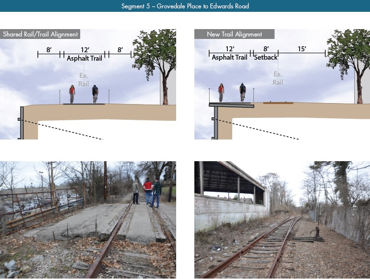
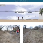
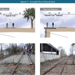
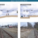
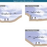
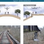
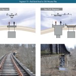
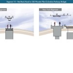
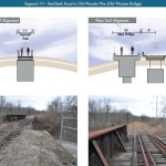
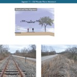
The cost estimates vary so much due to the three potential design options studied. The lowest cost alternative looked at placing a 12-foot-wide trail along the entire existing rail alignment. This, however, would make the inclusion of a future light rail line extremely difficult.

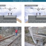
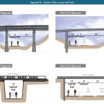
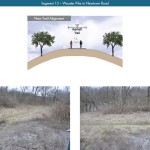
The most expensive alternative would construct an entire new trail alignment that does not interfere with any existing rail right-of-way. This would include the construction of several new bridges and completely preserve the ability to easily construct the long-planned light rail line adjacent to the new trail.

Alternative B, which was recommended by KZF and priced at $11.2 million, was a bit of a hybrid. It would include a 12-foot-wide trail offset from the existing rail alignment, but utilize existing rail right-of-way at pinch points along the corridor.

The 45-page study is the first detailed look at the corridor, which has been hotly debated and discussed over recent years. Much of the controversy has surrounded whether or not both light rail and a trail can be accommodated. KZF’s findings appear to show that much of the corridor could in fact accommodate both, but that some segments may prove to be difficult, albeit feasible.

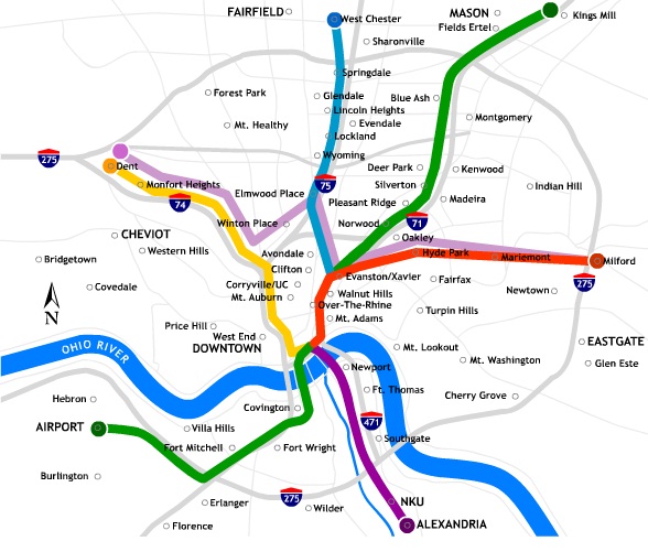
If project supporters are able to advance the trail plan, KZF estimates that it would connect eight city neighborhoods and approximately 100,000 residents with an overall network of more than 100 miles of trail facilities.

“It is hard to build in the urban core, and to find an intact corridor ripe for development is a unique thing,” explained Eric Oberg, Manager at the Midwest Rails to Trails Conservancy. “If this is done right, this can be the best urban trail in the state of Ohio. I have no doubt.”

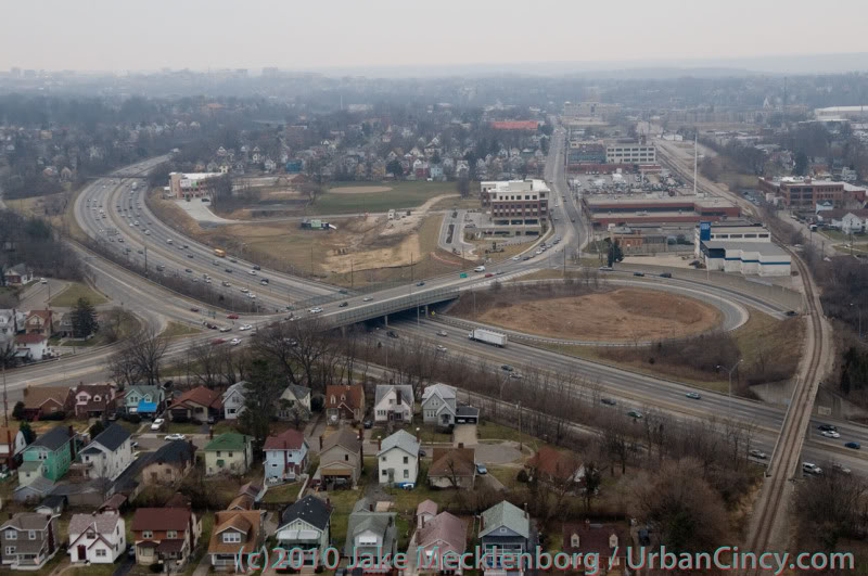
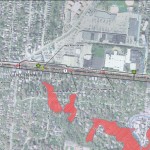
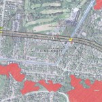
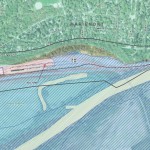
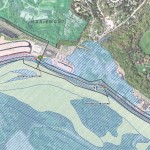
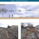
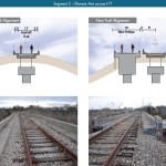
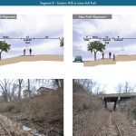
Some of the most difficult segments of the corridor are the nine existing bridges where the right-of-way is extremely limited. If both light rail and trail facilities are to traverse this corridor together, additional spans will be needed in order to have safe co-operation.

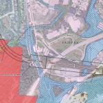
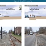
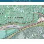
In addition to introducing what may become the region’s best urban trail and light rail corridor, some proponents also see it as an opportunity to fix other problems along the route. Most notably that includes the congested and confusing intersection of Madison, Edwards and Wasson Roads near Rookwood Pavilion.

While the newly released feasibility study offers the most detailed analysis of this corridor to date, the City of Cincinnati has yet to close on its purchase of the former freight rail line from Norfolk Southern.

City officials are reportedly in negotiations with Norfolk Southern now, and have made an initial offer of $2 million. In April, Mayor Cranley’s Administration also allocated $200,000 to the project.

Categories
Business Development News

Greiwe Development to Break Ground on $35M Hyde Park Condo Building This Week

Developers are aiming to break ground on a $35 million condo building in Hyde Park this week, following a months-long demolition effort that began in late October and cleared the site of five existing buildings, some of which dated back 80 years.

Greiwe Development and North American Properties (NAP) say that the demolition work cleared the way for what will become a modern four-story building that will house 30 luxury condominiums at the corner of Observatory Avenue and Shaw Avenue in Hyde Park.

Named 2770 Observatory, the development will also include a 77-space underground parking level accessible from Shaw Avenue.

The development will boast some of the priciest new residences in the region, with units priced between $700,000 and $2 million.

“Hyde Park combines the sophisticated lifestyle of Cincinnati’s premier neighborhood with the exciting air of arts, innovative restaurants and blocks of unique shopping,” said Rick Greiwe, principal of Greiwe Development.

Not everyone is thrilled about the luxurious direction in which Hyde Park continues to head. Former residents expressed frustration to UrbanCincy, saying they were given notice to vacate their apartments “by the end of the month” so that demolition work could proceed.

Over the years, this transition has led to a migration of priced-out Hyde Park residents to seek more affordable options nearby in Oakley, East Hyde Park or Evanston.

Griewe, however, says that the vibrancy of Hyde Park Square is part of what drew his development team to this location, and that the active and engaging lifestyle of city living is what is appealing to his firm.

Both Montgomery and downtown Cincinnati are locations where Greiwe says they would like to do additional work.

The announcement of 2770 Observatory comes as a wave of residential infill projects have been sweeping across Cincinnati’s neighborhoods. Thousands of new residential units are either currently under construction or planned to get started soon in Northside, Walnut Hills, Downtown, Over-the-Rhine, College Hill, Corryville, Clifton Heights, Columbia Tusculum and Avondale.

Instead of the residences being rentals, as is the case for most other projects around the region, 2770 Observatory follows in the footsteps of 2801 Erie Avenue and Michigan Terrace, which were completed in 2009 and 2007, by injecting high-end condos into one of the city’s toniest neighborhoods.

Griewe Development has become known for high-end, urban residential projects. In Mariemont, the company has completed 106 units in the heart of the village. That overall development program has been built over four different phases including Emery Park, Nolen Park and Jordan Park.

The development team says that they are pursuing a LEED Silver certification for the Hyde Park project, and that it is being completed without any financial assistance from the City of Cincinnati.

Cincinnati-based GBBN worked as the lead architecture firm on the project, while Messer Construction has been selected to build it in conjunction with NAP. Construction work is expected to begin this week, with units becoming ready for occupancy in fall 2015.

Categories
News Opinion Politics Transportation

EDITORIAL: Cincinnati Leaders Should Rethink Planned Rail, Trail Systems

Ten days ago UrbanCincy sounded the alarm on the proposed Wasson Way Trail, and we feel that due to the large amount of feedback that further explanation is needed.

Tomorrow at 12pm, City Council’s Strategic Growth Committee will discuss the proposal that would turn the Wasson Corridor from a railroad right-of-way into a recreational trail. What UrbanCincy is urging City Council to require is a minimum of 28 feet worth of right-of-way preserved for future light rail use.

Standard designs for bi-directional light rail traffic require a minimum of 28 feet of right-of-way. Along some portions of the Wasson Corridor it may very well be possible to accommodate 28 feet for light rail, plus additional right-of-way for the proposed recreational trail, and in those segments it may make sense to get started.


Looking east as the Wasson Line crosses over Interstate 71. Photograph by Jake Mecklenborg for UrbanCincy.

While there is no funding currently in place to build light rail along the Wasson Corridor, it would be short-sighted to remove one of the best rail transit corridors in the city. This was previously done on Cincinnati’s west side when an abandoned railway used by freight and passenger rail traffic was abandoned and then allowed to be built over and occupied by the Glenway Crossings retail center.

Allowing this to take place offered city and county leaders to reap the rewards of a short-term boost, but it has also created a situation that makes building light rail to Cincinnati’s western suburbs almost impossible. This same thing could happen to Cincinnati’s eastern suburbs should the Wasson Corridor be used by a recreational trail.

Proponents of the Wasson Way Trail project made it clear that many of the supporters also want to see light rail eventually happen, but that we should not wait until that day comes to improve the visual appearance of the corridor. Case studies from all over the United States show, however, that once a former rail line is converted into another use, it is almost always an impossible political task to take that land back for rail purposes.


2002 regional light rail plan for Cincinnati.

In the larger scheme of things, UrbanCincy believes that regional leaders need to take a step back and ask themselves why we are still discussing commuter rail along the Ohio River, and a recreational trail through densely populated city neighborhoods. The priorities should be reversed, and the Oasis Line along the Ohio River should be converted into a recreational trail while the Wasson Line is preserved for future light rail use.

It is estimated that the Wasson Light Rail Line would attract three times the number of riders than the Oasis Commuter Rail Line, while also being significantly less expensive to build and operate. Futhermore, when discussions were held about the Oasis Line, residents and property owners along the line voiced their opposition to such activity and have conversely expressed interest in seeing the railway converted into a recreational trail.

City and regional leaders should maintain the natural beauty of the Ohio River and turn the Oasis Line into an attractive recreational trail that can connect into existing trail networks to the east, and the Wasson Line should be preserved for light rail use in the future. It may seem frustrating to leave the Wasson Line in its current state of appearance, but it will be much more frustrating to jeopardize one of the best potential light rail corridors envisioned for the region.

Categories
Business Development News Opinion Transportation

Cincinnati’s Wasson Railroad Corridor Should Not Be Converted Into Recreational Trail

In the post-industrial United States cities all across America have been left with an abundance of rail right-of-way that once served industrial properties. Cities have since struggled to find a use for these rail corridors.

In many cases the rail right-of-way either gets built over, or makes room for some other use – most typically a park or trail of some sort. The most famous, and perhaps most unique, example of this is New York City’s Highline which converted an abandoned freight rail corridor into an elevated park. In most cities, however, much simpler trails are developed in order to cater to bicyclists and pedestrians.

These are great projects, but in the cases where rail right-of-way is needed in order to introduce rail transit, they should not be done. The acquisition of right-of-way can be one of the most difficult hurdles to clear when developing rail transit, so if you have a prime corridor intact, you should do everything in your power to preserve it for future rail transit.


Map of the proposed Wasson Way Project.

The reason this is particularly important in Cincinnati right now is because on March 6, advocates of what is being called Wasson Way Project will present their ideas for converting the Wasson Corridor into a bike/ped trail to City Council’s Strategic Growth Committee.

The idea is not a bad one on face value, but should it proceed it would eliminate one of the most valuable rail corridors in the city. A corridor that could connect neighborhoods like Hyde Park, Oakley, Evanston, Norwood, Mt. Lookout, Fairfax and Mariemont with light rail and eventually connect those neighborhoods to the region’s two largest employment centers – uptown and downtown – without much additional track or right-of-way acquisition.

“I know of no example in the United States where a former railway that has been converted to a bike/hike trail has ever been returned to passenger rail service,” explained Cincinnati transit advocate John Schneider (aka “Mr. Transit”). “Once it’s gone, it’s gone.”

Rail corridors that run through areas of limited potential transit ridership like the Oasis Line should be redeveloped into trails. It just makes sense. There is less automobile traffic and the riverfront trail provides a scenic ride for bicyclists and connects its users to a string of riverfront parks.

The Wasson Line, however, is ripe for light rail service with its densely populated neighborhood, vibrant business districts and key attractions along the line. The Oasis Line should become a bike/ped trail, but the Wasson Line should not.

Unfortunately the exact opposite is progressing for both of these lines in Cincinnati. Hamilton County officials continue to explore funding options to turn the Oasis Line into a commuter rail corridor, and a citizen-led group is strongly advocating for the conversion of the Wasson Line into a bike/ped trail.

While UrbanCincy supports conversion of some rail right-of-ways into other uses, we believe it needs to be done in a thoughtful manner that considers the future transit needs of the region. The Wasson Line is too valuable to convert into a bike/ped trail and should be preserved for an urban light rail line.

The upcoming committee meeting is scheduled to take place at 12pm on Tuesday, March 6 at City Hall (map). We would like to urge you to come out and support the future of regional light rail in the Cincinnati region, and request that the Wasson Corridor not be converted into a recreational trail.

Categories
News Politics Transportation

Residents Take Stand Against Proposed Highway Through Cincinnati’s Eastern Neighborhoods

In December 2010, the Ohio Department of Transportation (ODOT) published its 2011-2015 Major New Construction Project List. The list included funding to resume study of the highway component of the controversial Eastern Corridor Project. Dormant since 2006, the sudden reappearance of the highway project alarmed area residents, more than 100 of whom gathered at the Madisonville Recreation Center on August 3 for a meeting of Cincinnati City Council’s Livable Communities Committee.

On display were ODOT’s two circa 2006 Tier 1 alternatives, one of which called for the complete replacement of Red Bank Road with a fully grade separated interstate-style highway. This drawing, seen for the first time by most in attendance, emboldened suspicions that the Eastern Corridor Project is in fact a veiled attempt to extend Interstate 74 across Hamilton County.

I

“We urge ODOT to unbundle the Eastern Corridor projects and concentrate on providing transportation alternatives in this community, not another highway,” exclaimed one resident at the recent City Council committee meeting. “Reallocating resources to utilize the Wasson Line will produce more cost-effective transportation alternatives for thousands including Madisonville citizens.”

Citizen feedback generally welcomed improvements to Red Bank Road, especially a boulevard or parkway that might compare favorably to the more attractive roads in the area. Many also suggested development of better public transportation, especially implementation of light rail transit on the abandoned Wasson Road railroad.

Read UrbanCincy‘s exclusive in-depth analysis of the Wasson Line and Oasis Line.

Opposition to construction of an expressway in place of Red Bank Road was unanimous at the meeting, and citizen comments were followed by stern questioning of ODOT officials by City Council members Roxanne Qualls, Laure Quinlivan and Chris Bortz.

ODOT assured the committee that the Tier 1 alternatives on display would be reworked and that it will work closely with Madisonville Community Council and other neighborhood groups to ensure a favorable outcome. ODOT officials also remarked that the City of Cincinnati and other jurisdictions through which the Eastern Corridor Project will pass will have to approve ordinances to allow its eventual construction.