Categories
Arts & Entertainment News

Cincinnati Dronescape is a Soundtrack of the City and the Sounds That Define It

Cincinnati has a rich history in music production, and recently it has become more of a hotbed for live performances. In addition to that, there are a number of well-known local or locally started musicians out there making the national rounds these days.

A new mashup project, however, is a bit of a change of pace from all of that.

Cincinnati Dronescape is the brainchild of Isaac Hand, and is a bit of an experiment involving art, music, technology and the city.

Hand worked with his friend Nick Denlinger to record what they thought were quintessential sounds from around the city. This included recordings from more than a dozen locations including the sound of the Western Hills Viaduct, Queensgate Railyard, Christian Moerlein Brewerythe hum of the University of Cincinnati Medical Center. From there, they then distributed the audio recordings to local musicians who them composed music to complement those sounds.

One of the interesting components of the project, aside from it recording background city sounds, is the fact that Hand and Denlinger recorded the sounds by using drones.

“The results are simultaneously a representation of the diversity of the Cincinnati music community, but also an aural portrait or sonic map of the city,” explained Hand.

Long-time readers of UrbanCincy may remember Hand from a project he helped champion in 2010 called Aural Grid, which was a “musical-spatial exploration” through Over-the-Rhine. Many of the artists involved with that project, Hand says, were also involved with Cincinnati Dronescape.

“Although I curated it, this really was a community endeavor,” Hand emphasized. “It took a whole bunch of people to make it possible.”

The community description is an apt one with roughly a dozen musicians contributing directly to the effort. In addition to that, Ian Gullett mixed everything into a cohesive recording, Arthur Brum produced the album artwork, and Micah Freeman composed the poem used for linear notes.

Nick Swartsell, who has grown increasingly fascinated by the history of the West End and its Kenyon Barr neighborhood, has even been working on a visual component to complement the track he contributed for the album.

It actuality, there are two albums available for streaming or purchase. The first, entitled Cincinnati Drones, is an album of the recorded sounds, while the second, entitled Cincinnati Dronescape, is the collection of artist remixes of those sounds.

Both albums can either be downloaded online for $7, or purchased in CD form for $10 on the project’s bandcamp webpage, Shake It Records, Everybody’s Records, Rock Paper Scissors and Torn Light.

Categories
Development News

Winners of ULI Competition Propose Bold Infill Development for Walnut Hills

ULI Hines Cincinnati Competition Winning TeamIn an effort to reach a younger audience and provide real life experiences to students and future professionals of the construction and development industry, the Urban Land Institute Cincinnati Chapter collaborated with the University of Cincinnati in a local competition that offered a $5,000 prize to a winning design for infill development proposals for the Walnut Hills neighborhood.

The competition was modeled after the ULI Hines National Competition, which calls for unique interdisciplinary work among student teams from throughout the country for feasible urban development concepts.

The Cincinnati competition, however, went one step further by including a mentoring program, in which local professionals worked directly with student teams over an eight-week period in September and October. The 17 participating students came from the University of Cincinnati’s schools of Architecture, Urban Planning and Real Estate.

The participants were divided into four teams, each with assigned ULI professional mentors well recognized for their achievements in their respective fields. Weekly lectures were also provided by professionals in local real estate, architecture and urban planning and design offices in order to expose the students to case studies and useful tools commonly used in professional practice.

In an effort to diversify academic participation, the Niehoff Urban Studio once again collaborated with the Lindner College of Business Real Estate Center and the University’s ProPel program to organize the course. Additional participation and assistance was provided by the Walnut Hills Redevelopment Foundation acting as the chief client, while BHDP Architecture established the competition brief.

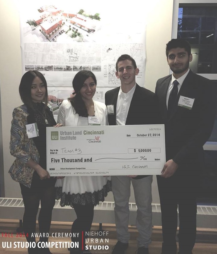
The work culminated on Monday, October 27 at the ULI Studio Competition Reception and Award Ceremony at the Niehoff Urban Studio’s Community Design Center in Corryville.

During this closing event, each team was given 40 minutes to make the case for their proposal and field questions from eight-member judging committee comprised of Brian Copfer (CORE Resources, Inc.); Traci Boeing (WesBanco Bank); Jeanne Schroer (Catalytic Development Funding Corporation of Northern Kentucky); Eric J. Gardner, MAI, CCIM (Pillar Valuation Group, Inc.); Graham Kalbli, AIA, AICP, LEED AP (New Republic); Kevin Wright (Walnut Hills Re-development Foundation); Jeff Raser, AIA, LEED-AP (Glaserworks); and Craig Gossman (Gossman Group).

The winning team, which included Kyle Zook (SAID-DAAP), Bahareh Rezaee (SOP-DAAP), Yue Yan (SOP-DAAP) and Rocky Grewal (Finance-College of Business), was awarded the competition’s $5,000 prize.

Although diverse in nature, the competing designs responded to existing form based code guidelines, the historic neighborhood context, and a mixed-use program brief which called for the incorporation of residential, live/work and retail uses. The winning team’s design set itself apart, however, by using the concept of continuity to aggregate the mixed-use program and buildings around a central public space.

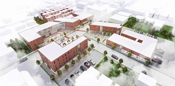
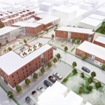
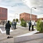
Called Firehouse Row, the winning design addressed three blocks of McMillan Street near the center of Walnut Hills. The location is well-suited for infill since each lot is primarily vacant and surrounded by neighborhood residences.

“The design for a mixed use development on the site was comprised of a variety of methodologies intended to create a relationship with the surrounding public and implement a notion of connectivity not only within the building but also spanning across the different blocks,” the winning team explained.

“At a time of heightened interest for the neighborhood and the possibility of increasing densities, an approach of flexible spaces that cater to the present day inhabitants, and what shifting demographics may follow, was implemented in order to mitigate wasted and vacant spaces.”

While primarily an academic exercise focused on the experience of working in a professional setting, the competition aimed to better prepare students in urban development fields to respond to real world situations and work environments. It also provides leaders in the increasingly hot neighborhood with a vision for how the area could be developed.

EDITORIAL NOTE: Ana Gisele Ozaki, who has worked at the Niehoff Urban Studio’s Community Design Center as an adjunct professor following her graduation from DAAP’s Masters of Community Planning program in 2013, was the author of this story. Due to a system error, an earlier version incorrectly attributed it to Randy Simes.

Categories
Up To Speed

Mapping May Impede Self-Driving Car Development

 Mapping May Impede Self-Driving Car Development 

Urbanists, futurists and car enthusiasts buzz has been building over self-driving car technology. Traffic planners see them as a way to improve traffic flow on congested roadways. However; Slate’s Lee Gomes takes an in-depth look into the technology behind the curtain of the self-driving car and his conclusion is that it’s not ready for prime-time and it may never be ready. More from Slate:

But the maps have problems, starting with the fact that the car can’t travel a single inch without one. Since maps are one of the engineering foundations of the Google car, before the company’s vision for ubiquitous self-driving cars can be realized, all 4 million miles of U.S. public roads will be need to be mapped, plus driveways, off-road trails, and everywhere else you’d ever want to take the car. So far, only a few thousand miles of road have gotten the treatment, most of them around the company’s headquarters in Mountain View, California.  The company frequently says that its car has driven more than 700,000 miles safely, but those are the same few thousand mapped miles, driven over and over again.

Categories
News Opinion Transportation

Transit Users Will Need 7 Hours to Commute to ODOT Public Transit Meeting

An event making the rounds on social media hosted by the Ohio Department of Transportation (ODOT) provides an opportunity for citizens to tell Governor John Kasich’s (R) administration about public transportation improvements they’d like to see in their city. The public meeting to discuss statewide transit needs is hosted on Friday, October 31 from 10am to 12pm at the Warren County OhioMeansJobs Center in Lebanon.

While the gathering has good intention, it fails to meet the basic criteria of planning a public involvement meeting:

  1. Never host a public meeting on a holiday.
  2. Never host a public meeting on a Friday or weekend.
  3. The location of a public meeting should be accessible to all members of the community and able to attract a diverse group of citizens.

By car, Lebanon is roughly a one hour drive north of Cincinnati, and a 30-minute drive south from Dayton. It’s also the city where the regional ODOT office is located; understandably why the administration would opt to hold a public involvement meeting here. What went unconsidered are the needs of people that the public meeting is focused on: citizens reliant on public transportation.

The closest Metro bus stop to Lebanon is 8.3 miles away, near Kings Island in Mason. Let’s say we’re feeling ambitious and attempt to take the bus, then bicycle the remaining journey to Lebanon. It would take 48 minutes to cycle to the meeting in addition to the 1 hour, 11 minute ride on the bus. Cincinnati Metro, the region’s bus system, only offers select service to the northern suburbs. In order to arrive on time for the 10am meeting, a person dependent on transit would have to catch the 71x at 7:45am, arrive in Mason at 8:52am, then continue to the meeting on bicycle.

Getting back home is another story. The public involvement meeting adjourns at 12pm, but the bus route that services Mason is a job connection bus, meaning it only runs traditional hours when people are going to and from work. After another 48 minutes of cycling back to the bus stop, the inbound 71x picks up shortly after 3pm and returns to Cincinnati at 4:40pm.

In summary, if a citizen dependent on bus transportation wishes to give ODOT their input, they would spend 7 hours commuting to the two hour meeting, and need to able-bodied to ride a bicycle for eight miles. What about senior citizens and people with disabilities? Who can afford to take an entire day off work to attend a meeting? As a transit rider who has a car, driving an hour each way to attend the meeting –in the middle of the work day– for me, is inconvenient and unfeasible.

The poor choice of trying to combine Cincinnati and Dayton into one meeting was an unfortunate oversight in event planning. Instead, meetings should be hosted in the downtown of each city, just like they have been in Columbus and Cleveland which are also participating in the ODOT series.

Since 2011, Governor Kasich has cut $4 million from the state’s public transit budget, leaving Ohio with one of the lowest funded transit systems in the country. If there’s a genuine interest in hearing how those cuts affect the people that rely on public transportation the most, the administration needs to schedule a second meeting in Cincinnati near Government Square where those people can actually get to.

Of course, this isn’t the first time area transit users have been ignored when it comes to public meeting locations. Earlier this year, Ohio Secretary of State Jon Husted (R) upheld a decision to relocate Hamilton County’s Board of Elections office to a location that would take up to four hours to access by transit.

Categories
Development News Opinion

Redesigned Streetscapes Could Turn Fourth and Race Streets Into Vibrant Public Spaces

Fourth Street offers one of the more impressive urban street canyons in all of America. Its pre-war high-rises dominate the streetscape and offer a glimpse into the proud history of Cincinnati.

Once the very center of business activity, Fourth Street was historically known as the region’s financial district – a place where all the power players lingered and conducted business. Since its heyday in the early 20th century, that center of financial clout has shifted. Some say it has shifted to Third Street, while others say it has moved east along Fourth or even north to Fifth Street.

In any case, many of those power players are now in other nearby districts, while the impressive structures they built are left behind.

City leaders had believed, with good reason, that Fourth Street would become the region’s premier shopping destination. However, with the demise of downtown malls and department stores, that vision never fully came to be.

All has not been lost though. Virtually all of the impressive, historic urban fabric remains and has since been largely converted into residential space. There is also a movement afoot from some business and civic leaders to breathe new life into not only Fourth Street’s retail scene, but Race Street’s as well.

Part of the ongoing transformation includes Mabley Place, which converted the former Tower Place Mall into a parking garage with street-level retail, the proposed 30-story residential tower that would replace the aging Pogue’s Garage, and the nearby and soon-to-open dunnhumbyUSA headquarters tower.

There is even the possibility of Fourth Street being converted back to two-way traffic following the activation of the now unused ramp to I-75 from Third Street.

As all of these projects start to become reality, they offer a unique opportunity to redo the public space in the area. One particular area that has long needed a redo, and has been the subject of many studio projects at DAAP, is Fourth Street’s dated streetscaping. Not only does the design of the sidewalks, benches and street trees leave much to be desired, they also do not follow standard good design practices.

The renovation of Fountain Square realized this and implemented good urban design practices in its final product. Things like softscaping and movable furniture are powerful elements to a good public space. The same could be done along Fourth Street’s, and for that matter much of Race Street’s, wide sidewalk widths.

Being in the midst of the digital age, it would also make sense to make the area more welcoming to tech users by implementing Internet hot spots and including solar-powered charging stations at benches and tables set up along the street.

Specifically, the areas best suited for such a transformation would be the north side of Fourth Street between Vine and Elm, and the east side of Race Street between Fifth and Seventh.

With more and more hotels opening up downtown in general, and specifically on or very near Fourth Street, this public space could also serve as a convenient and desirable ‘third place’ for travelers that are looking to spend some time out in the city, without feeling obligated to purchase endless cups of coffee or beer, but not also be trapped inside their hotel room.

Such a design could also activate the largely lifeless corridor with people from all backgrounds, and provide more passing customers for existing and potential businesses looking to setup shop there.

With all the construction taking place and about to get started, it would make most sense to leverage these private investments to improve this public space at the same time. Heck, it might even be the perfect opportunity to connect the new Central Parkway Cycle Track with the Ohio River Trail.