UrbanCincy occasionally publishes pieces written by guest contributors. If you would like to share an article or editorial that is relevant to UrbanCincy's audience, please contact us at editors@urbancincy.com.
Civic Cincinnati is Cincinnati’s Strong Towns Local Conversation group. Strong Towns advocates for cities to be safe, livable and inviting, with a pattern of development that’s financially strong and resilient.
That doesn’t describe Hyde Park Square today. It shows a lack of vibrancy demonstrated by the paucity of people walking and congregating there. By removing buildings that have not kept up with modern building standards and renovating another building, the developer hopes to change this, bringing new residents and visitors to the Square and its businesses.
Every city neighborhood has concerns about traffic safety, especially for vulnerable children. Blaming development for furthering these problems denies the reality that additional density actually improves pedestrian safety.
More people walking through and around Hyde Park Square sends a signal to drivers to use caution when driving there. That, in turn, encourages more people to walk rather than drive. Hyde Park can continue to improve safe and comfortable walkability by making further traffic calming enhancements a priority for future budget requests.
While neighborhoods have an important voice in development plans, their concerns must be tempered by the need to build more housing city-wide. Giving neighborhoods veto power over development will not lead to the kind of strong, resilient neighborhoods the city needs, and which this council has bravely stood up for.
Every new project promises to change the familiar landscape neighborhood residents consider their home. Planning for opposition needs to be an important element of the process. The city can’t afford to allow that opposition to prevent the progress we must make to increase housing at all levels and price points. That’s what we’ve elected you to do – make the hard decisions that benefit the entire city.
Connected Communities is a first step in unleashing the power of zoning reform to increase housing in Cincinnati. No neighborhood can be exempt from change. We support efforts for the developer and their intermediary to work with Hyde Park’s residents, businesses, community council and organizations on a design that will make all of them proud of their community in 20 years.
We love Cincinnati. We want to stay here. Many of us are recent college graduates or in the early stages of our careers. We’re finding it tough to find rental housing in neighborhoods where we want to live, and buying a house seems like an impossible dream.
We need our city leaders to recognize that we’re the city’s future. Our needs are as important as those of longtime residents who oppose the development our city needs to house us now, and attract more of us to make our lives here.
The following is a guest post by Indianapolis based planner Jeffrey Tomkins with a forward from Micah Paldino, Clifton Heights resident, and founder of creative storytelling agency, Fallon Thatcher. It has been edited lightly.
“With the area in and around Findlay Market expanding with new restaurants, bars, and lifestyle concepts, the neighborhood is primed and ready for a conversation around how we provide a safer and more beautiful experience.
This is timed nicely with ongoing construction of FC’s stadium set to open in March 2021 that will bring even more focus on how pedestrians utilize this space. Visibility for pedestrians at this important, but rather troubling and cumbersome, intersection has always been a pain point when crossing the street and competing with cars.
In this reconfiguration designed by Jeffery Tompkins it lessens the risk for pedestrians by reducing the allowances of turns and creates a calmer environment. This is something we need more than ever as Over-the-Rhine and Clifton Heights become a more singular unit.”
Micah Paldino
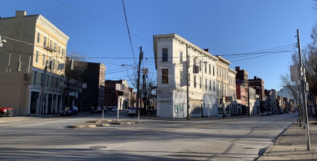
Vine Street and McMicken Avenue today. Photo by John Yung.
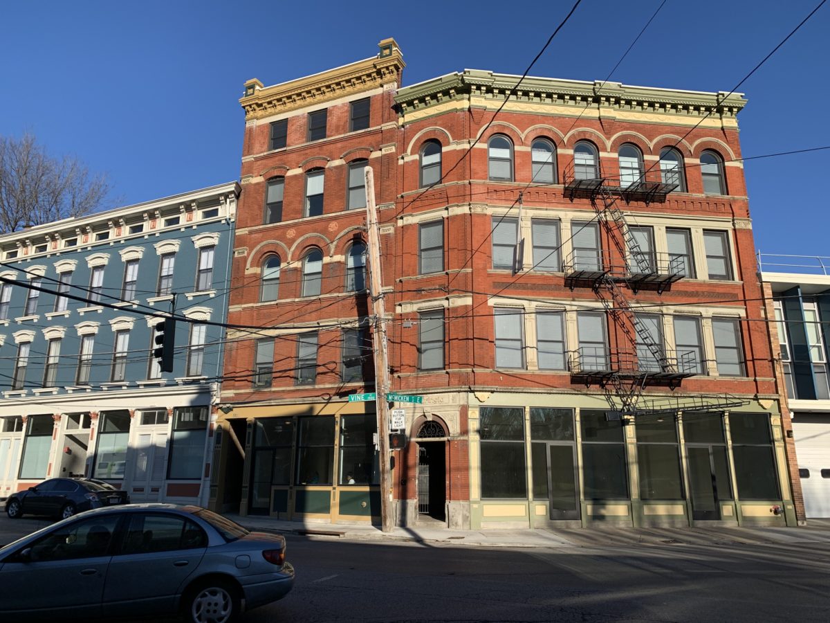
The intersection of Vine St. and McMicken St. is one of Cincinnati’s more complicated – and potentially more deadly. While it has been the subject of art, the first search engine result for the five-way intersection lists pedestrian deaths as its biggest story. And this is no surprise: complicated turn radii, low vehicle visibility from a wild angle of incidence, and an antiquated slip lane have created a logistical nightmare for cyclists and pedestrians hoping to cross the intersection.
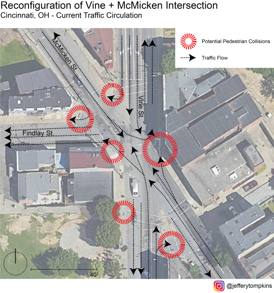
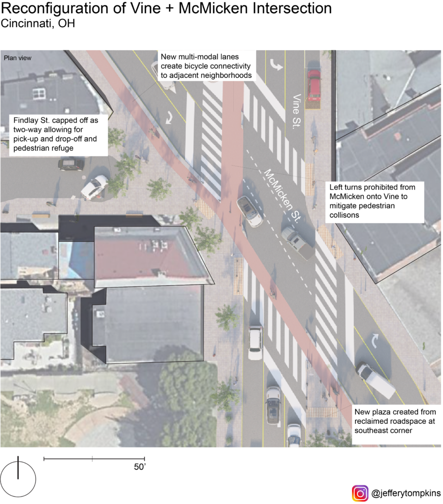
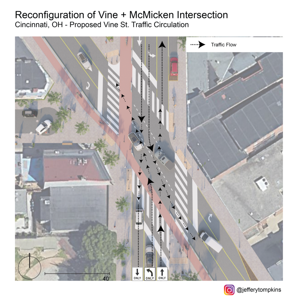
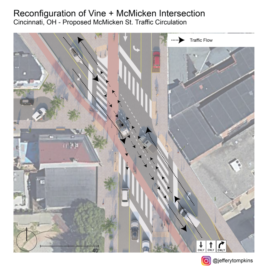
Current Traffic Circulation
Any design intervention hoping to calm traffic and improve mobility at this nexus should account for the district-wide significance of this crossing and, thus, must think in terms of the relevant traffic flow through Vine and McMicken corridors. As it stands, current traffic flow is overly complicated and caters almost entirely to automobiles rather than encouraging pedestrian interaction.
Seen from this map, the wide turn radii and allowance of multitudinous turning options fosters inhospitable conditions for peds, with several critical points ripe for accidents. On top of decreasing pedestrian safety, this wide array of turns also can negatively impact traffic flow and connectivity between adjacent neighborhoods. To fully reconfigure the intersection to allow for smoother traffic flow and safety, traffic flow of the corridor should be reanalyzed and possibly rerouted.
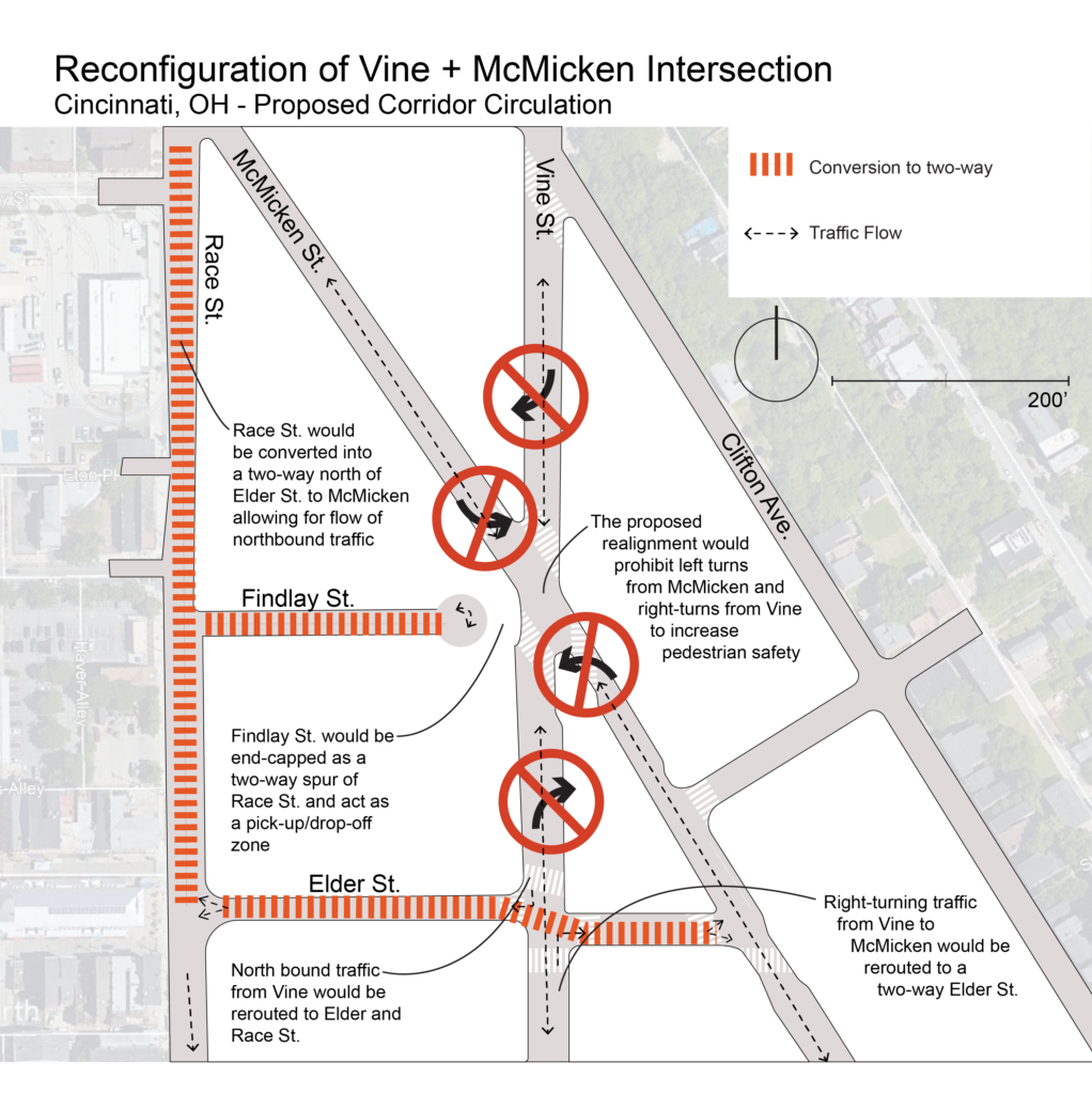
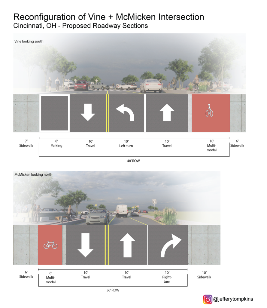
To allow for a complete-streets redesign of Vine/McMicken, my proposal eliminates left turns from McMicken onto Vine and removes right turns from Vine onto McMicken. North-bound traffic on Vine intending to turn right on McMicken would be rerouted to a new two-way Elder St. allowing for southbound travel. South-bound traffic on Vine intending to turn right on McMicken would instead be rerouted south to a two-way Elder and directed north-ward on a reconfigured two-way Race St. north of the Cincinnati streetcar connector, leaving the slip lane redundant. North-bound traffic from McMicken onto Vine would be routed south from Pace to Elder and then north on Vine. South-bound traffic from McMicken to Vine would instead utilize Elder as a conduit between the two streets. While this reconfiguration could create inconveniences for residents in the near-term, it is with a long-term eye toward saving pedestrian lives that makes it worth it. Atop this, the redesign hopes for slower traffic, improvements in overall traffic flow with elimination of one-ways, and a reduction in accidents.
Corridor Flow Map
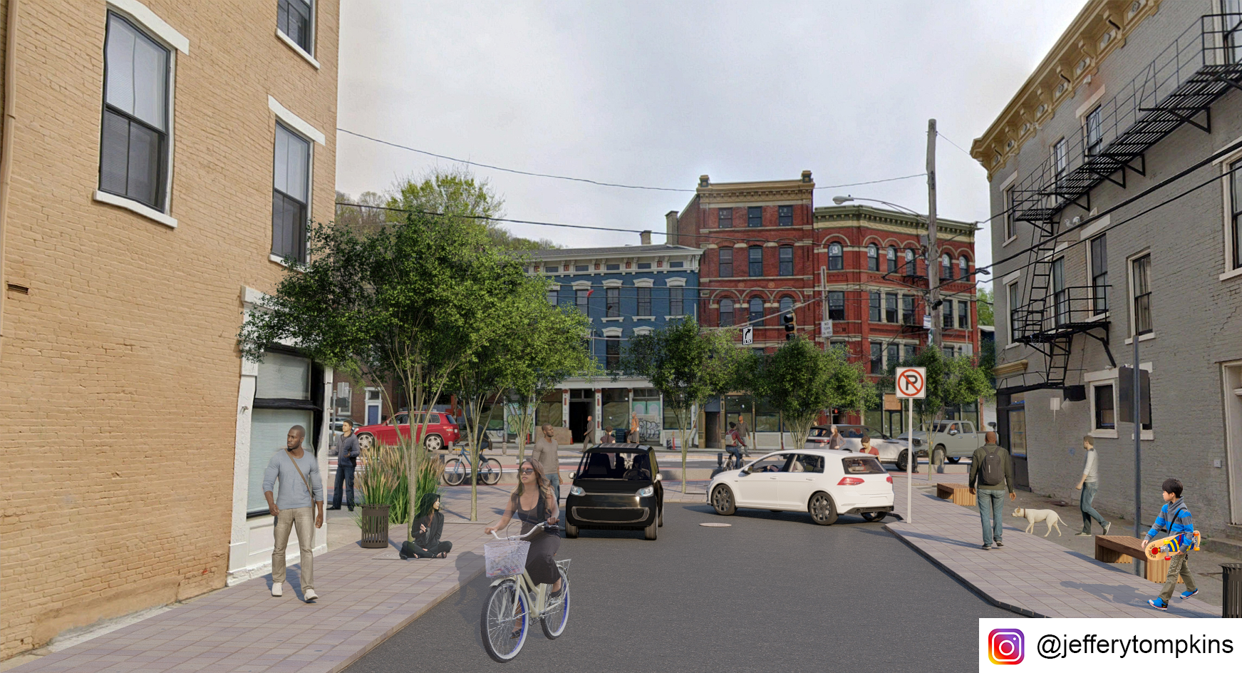
Aside from turn-regulation at the intersection, my proposal forVine/McMicken involves the capping of Findlay St. to eliminate the five-way and diminish incidence points. With this reclaimed space from the new configuration and removal of slip lanes, public space would be created, and pedestrian sightlines would be vastly improved at the new four-way intersection.
Plan View
The new configuration calls for a reduction in vehicular space and the inclusion of multi-modal lanes catering to mid-speed travel (bicycle, scooter, powerchair, etc.) along Vine and McMicken. The reclaimed slip lane at the southeast corner would be reallocated as a public plaza and pedestrian sanctuary protected by bollards and activated by food carts or public art. A 6’ multi-modal lane along McMicken would improve connectivity for bicyclists along the corridor and offer a commuting solution for Over-the-Rhine residents. The 10’ multi-modal lane along Vine would take the place of the current right-turn lane and give a north-bound option for bicycle connectivity. One side of street parking would still be retained north and south of the intersection on both streets. The capped-off Findlay St. would become a possible pick-up and drop-off zone for rideshare and Uber/Lyft.
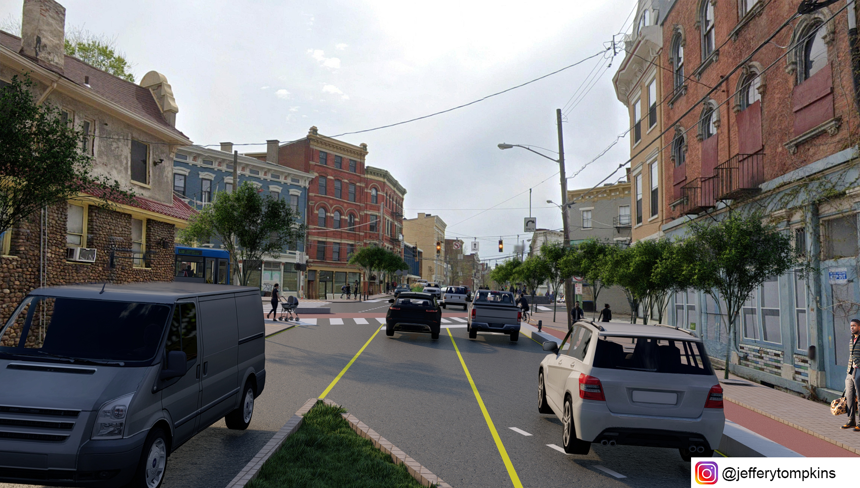
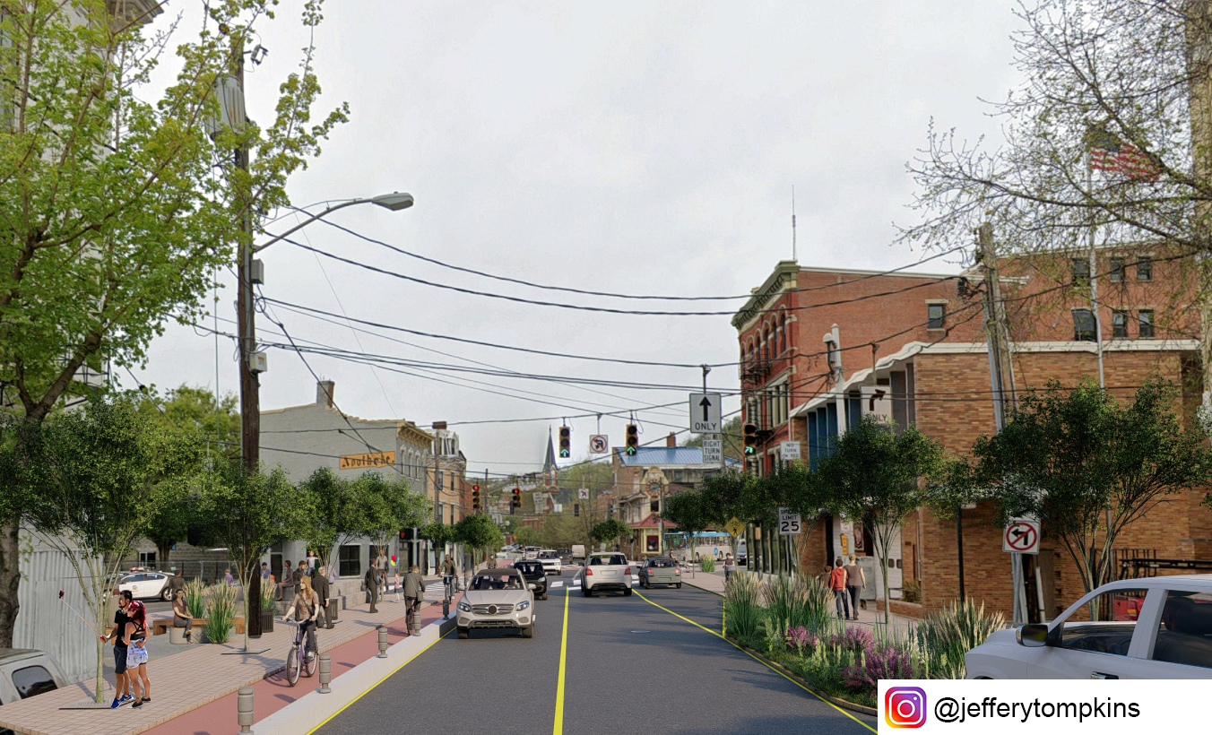
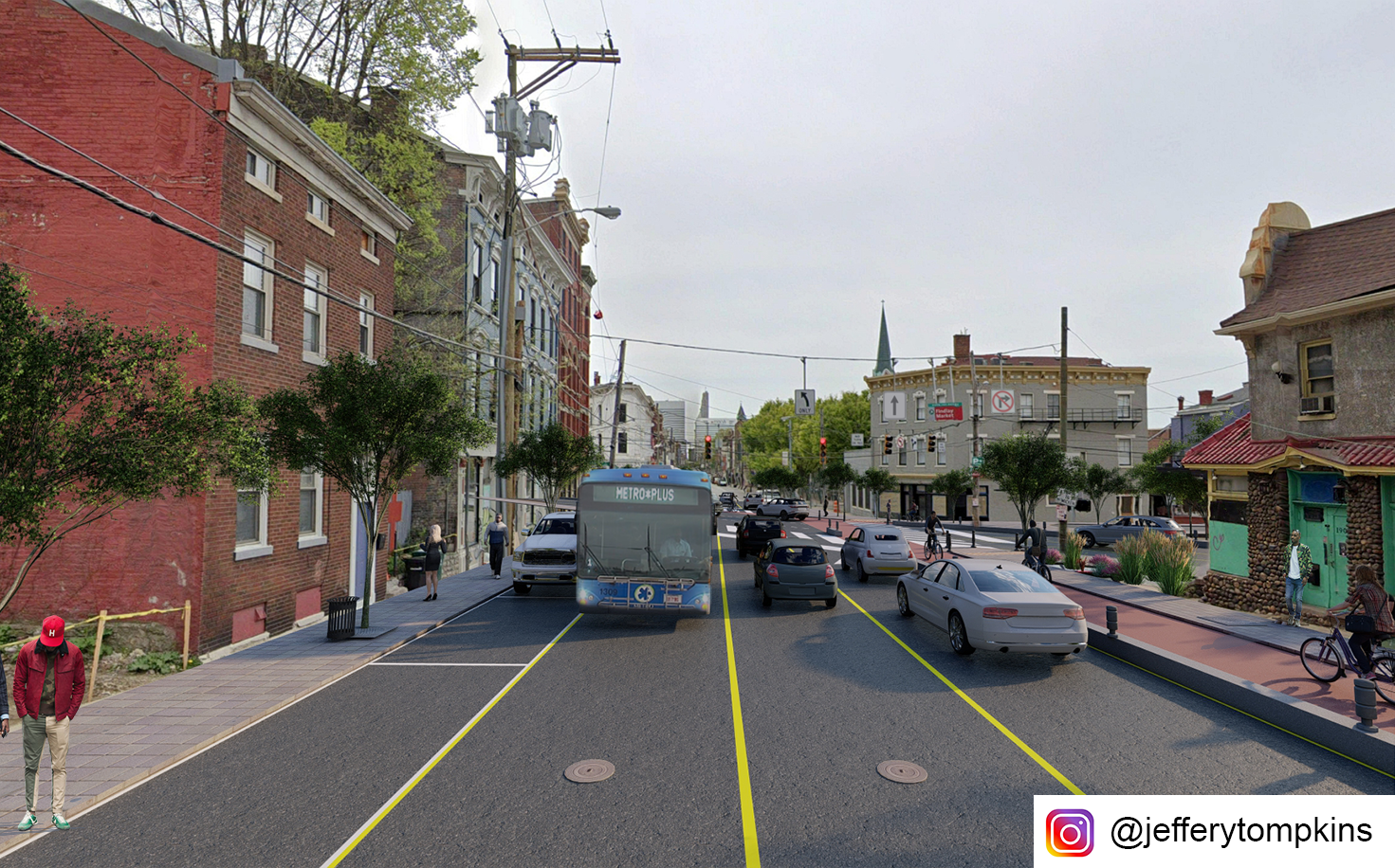
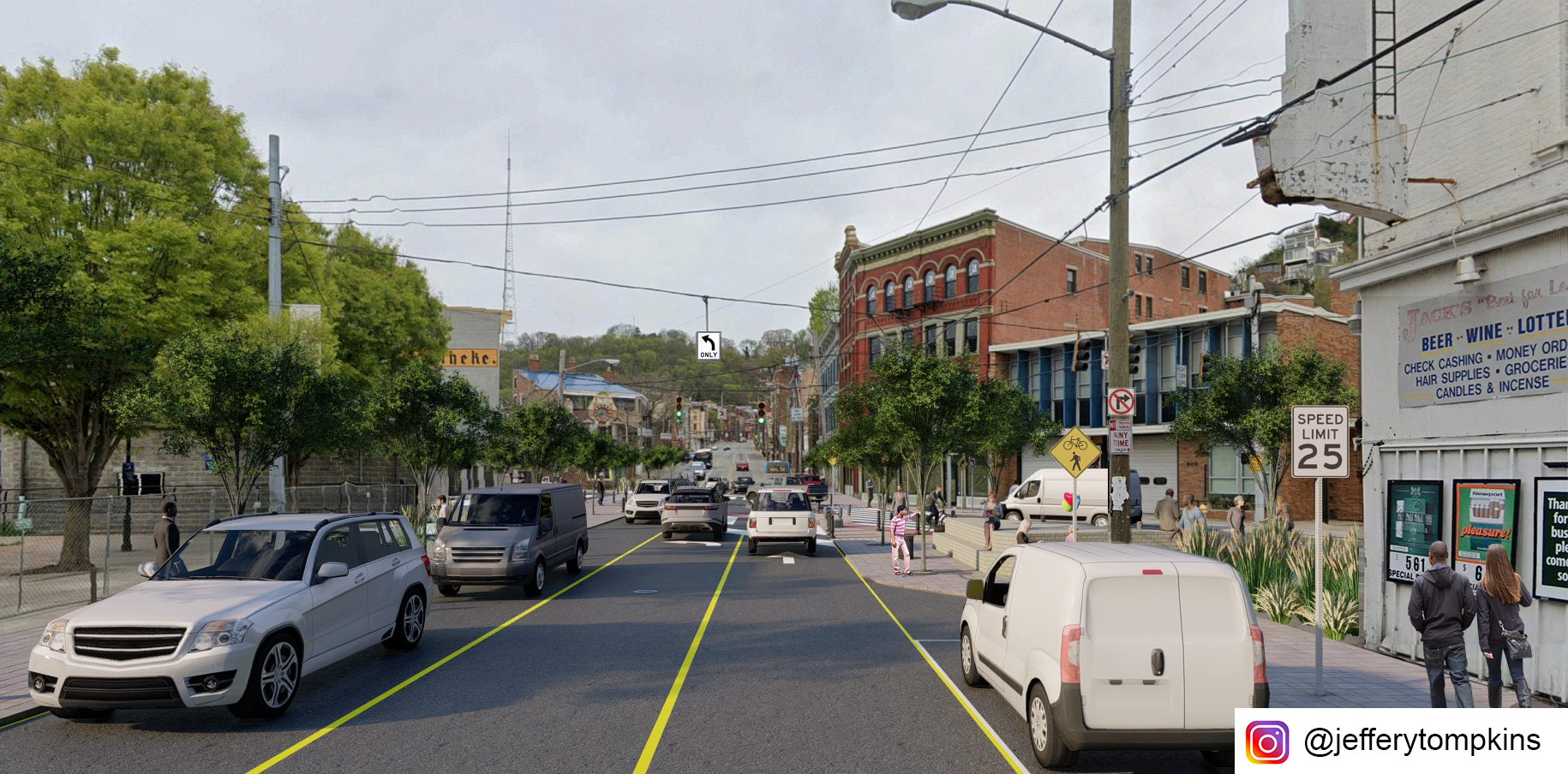
Looking southeast on McMicken Ave
Looking northwest on McMicken Ave
Looking east from Findlay Street
Looking south on Vine Street
Looking north on Vine Street
Render views of proposed intersection change. All illustrations by author.
Aside from fostering pedestrian safety and increasing bicycling viability, the redesigned intersection vastly improves overall traffic flow with its reduction in turns. This may offset future rates of accidents. While the reconfiguration would affect bus routes 46 and 78 currently turning from south-bound Vine onto Findlay to get to Race St. SB, the new configuration would allow for bus travel on the newly designated two-way Elder St, with traffic stop bars pushed back to allow for bus travel.
Vine Street Circulation
McMicken Ave Circulation
Street Cross Section
Overview and cross sections. All images by author.
If you would like to have your thoughts and opinions published on UrbanCincy, simply contact us at editors@urbancincy.com.
The underlying assumption of the Brent Spence Bridge project is that the level of congestion warrants relief with a new bridge and freeway expansion. The problem of congestion will be solved with new freeway capacity. However, that simple formula does not account for all the costs of the freeway expansion or the benefits not running a freeway through the urban core.
Two important pieces missing from the Brent Spence Bridge project cost/benefit analysis are the value of urban land and induced demand. As noted in a prior article, urban land is valuable. The sustained growth in Over the Rhine is local proof of the national trend that people want to live, work, and play in cities. Proponents of the bridge expansion project assume that the congestion relief is worth the price tag and loss of urban land for the next 50+ years. But what if the congestion relief is ephemeral?
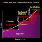
Others in Cincinnati have described induced demand. To reiterate, it is the propensity for freeway lanes to fill to capacity once they are created. New capacity creates new demand. Decreasing the cost of driving with shorter, faster commutes, increases the number of drivers. Road expansions are intended to expand capacity and reduce congestion; however, new freeway capacity quickly fills up and becomes just as congested as before.
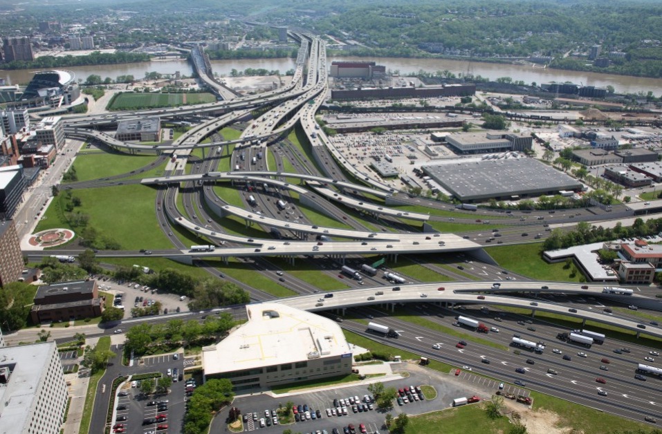
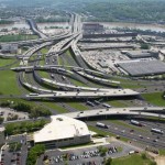
Proposed approach to the Brent Spence Bridge, Kentucky side
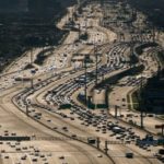
Katy Freeway in Houston Texas
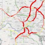
OKI Projected congestion model for 2012
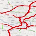
OKI future traffic model for 2039
A chart illustrating Induced Demand
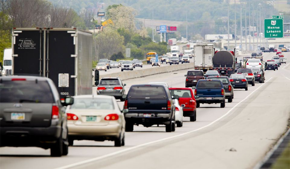
There appears to be no upper limit at which enough lanes eliminate capacity. The Katy Freeway in Texas provides the case in point. First constructed in the 1960s, it was six to 8 lanes wide. A $2.8 billion expansion project finished in 2011 that expanded it to one of the widest freeways in North America at 26 lanes: At one segment each direction has 6 lanes of through traffic, 4 feeder lanes, and 3 HOV/toll lanes. Travel times decreased immediately after the expansion, and in 2012 the Katy Freeway was hailed as a success story. However, by 2014, travel times increased 30 percent during the morning commute and 55 percent during the evening commute. $2.8 billion and 18 extra lanes improved traffic for three years, then made it worse than before the project. It achieved congestion relief for less than three years.
The predicted benefits of the Kary Freeway did not last. Cincinnati should learn from that lesson and include the effects of induced demand in the Brent Spence Bridge expansion cost/benefits accounting. The previous design did not adequately analyze induced demand.
Part of the reason that the project did not include induced demand as part of the analysis is that the software used to model traffic volumes is not up to the task. The model, called Static Traffic Assignment (STA), was designed to run on computers from the 1970s. Since you are reading this article on a computer there is no need to explain how much computers have changed in that time. There have been upgrades to the STA software but it retains the same fundamental architecture. STA produces usable predictions for daily traffic volumes but not for peak demand (rush hour). Accurate predictions of peak demand are necessary to understand induced demand.
There are two problems with STA that provide inaccurate peak demand forecasts. First, STA assumes roadway segments are independent, so that a problem in road segment “A” will not impact road segment “B.” In reality, congestion in one road segment does impact adjacent segments. Second, STA allows modeled traffic volumes to exceed capacity. If the model predicts capacity beyond what a given freeway can support, the model will queue vehicles up “outside the model.” In reality, those cars queued “outside the model” are either stuck in traffic or they’ve left the freeway and are taking surface roads to work.
The interstate system is a network that seeks equilibrium. If there is congestion in the network, drivers will avoid it. If there is capacity in the system, drivers will fill it up. The current Brent Spence Bridge project was modeled with STA. STA does not look at the network holistically. It either breaks up the system in segments or moves extra traffic outside the model. The failure to look at the system holistically makes it difficult for STA to predict where induced demand will come from and how intense the demand will be.
A better model now exists to forecast traffic. Called Dynamic Traffic Assignment (DTA), it is a more sophisticated computer model designed to run on contemporary computers. DTA holistically models an interconnected network in equilibrium. If a bottleneck causes a traffic backup, DTA assumes traffic will divert to surface roads rather than move outside the model.
The 2018 CNU Transportation Summit on Highways to Boulevards featured the presentation of a recent paper on DTA. Overall, DTA is a more powerful modeling tool that can better analyze effects on complex systems. There are five vehicular bridges over the Ohio River in Cincinnati, plus the two I-275 bridges. The traffic model must accommodate the regional impact of the bridge expansion on traffic, including the effects of induced demand. This is doubly important if the Brent Spence Bridge expansion is tolled and other bridges are not.
Existing Brent Spence Bridge Approach
Planned Brent Spence Bridge Approach
A DTA model of the Brent Spence bridge project will better show the impact of additional vehicles on local streets. Civic leaders in Cincinnati and Covington should have a better accounting of how moving an additional 50,000 vehicles per day through the urban core will affect their street networks, which must be paid for with city tax dollars.
Would it make sense to spend five years building the expansion project if the congestion relief dissipated within five years? Before moving ahead with such a large and expensive project there must be a full accounting of the costs and benefits. Particularly relevant to CNU, the loss of urban land has not adequately been included in the cost of the project. The benefit of congestion relief is diminished by induced demand. There are new tools at hand to better tally up these costs and benefits. A project the size and scale of the Brent Spence bridge expansion project requires a full and transparent accounting of the costs and benefits to move forward.
This is a guest article by Chris Meyer reporting on the 2018 CNU Transportation Summit. CNU and CNU Midwest are content partners with UrbanCincy. Chris is an Architect at Hub + Weber, PLC
If you would like to have your thoughts and opinions published on UrbanCincy, simply contact us at editors@urbancincy.com.
CNU’s 2018 Transportation Summit was September 16-17 in New Orleans. The purpose of the summit was to bring together people focused on the revitalization of urban neighborhoods disrupted by freeways. In attendance were people from Massachusetts, California, Colorado, Texas, Wisconsin, Washington DC, and two members from CNU Midwest, Chris Meyer and Brian Boland. There were many takeaways from the summit but three lessons seem applicable to Greater Cincinnati.
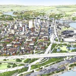
The first is that freeways and urban fabric are incompatible. Urban fabric in Greater Cincinnati typically consists of fine-grained parcels, 2-5 story buildings, and a dense street with grid pedestrian-scale streetscapes. Urban fabric is fundamentally sized for people. The 19th century blessed present-day Greater Cincinnati with an abundance of high-quality urban fabric. A minor takeaway from the transportation summit was that other cities would be jealous if they knew what we have.
Freeways are scaled for cars and trucks. They are always interruptions in the urban fabric. They break up the street grid wherever they pass through it and form barriers to people passing. The urban fabric for blocks around a freeway is degraded not only by the dirt, noise, smell, and ugliness but also by the profusion of vehicles they concentrate and deliver into the urban fabric. This is true for greater Cincinnati along the I-75, I-71, and I-471 corridors.
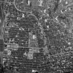
The aerial photo from 1955 shows the abundance of urban fabric. Orient yourself with union terminal at the left and downtown Cincinnati on the lower right. The west end is on the lower and middle left.
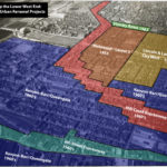
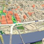
Graphical estimation of Urban Renewal projects in the West End. Illustration by John Yung
The white square from photo 1 is highlighted in photo 2. The west end was demolished and replaced with I-75 and the Queensgate industrial area.
Freeways are a necessary part of the urban economy but they are incompatible with the urban fabric. It was a mistake to run them through central cities. Dwight Eisenhower, the father of the interstate system, certainly thought so.
Multiple people at the summit noted that urban freeways are “monuments to racism.” That’s obviously the case in New Orleans. In Cincinnati, the West End neighborhood is physically gone but the Kenyan Barr photo exhibit, currently showing at the University of Cincinnati, illustrates the neighborhood destroyed by I-75. Ninety-seven percent of the residents were black.
A second lesson from the transportation summit is that urban fabric is valuable. Anyone familiar with CNU understands that. What was new is that urban fabric can be more valuable than the freeways running through it. Implicitly or explicitly, a big part of the argument to remove freeways, be it Denver, Oakland, or Austin, is to free up land for profitable new development.
The same principle applies to Cincinnati. The value of land with urban development on it is greater than the same amount of land with auto-centric development on it. The blocks around freeways are almost always taken up with auto-centric development because of how freeway ramps concentrate vehicles in a geographic space. Cincinnati would reap greater economic, tax, and social benefits if the space around Interstate-75 followed urban development patterns rather than auto-centric development patterns.
Auto-centric development near the urban core.
Pedestrian-scale development near the urban core.
The third lesson is that the future of urban development doesn’t have to look like the past. When the first Congress for New Urbanism met in 1991, most new development was going to suburbs and central cities were still losing money and population. That has changed. People are moving back to places where they can live, work, and play, without a car. It’s happening in Cincinnati too.
Recognizing the value of urban fabric and the cost of freeways in the urban fabric allows people to recalculate the costs/benefits of future transportation projects. Two high-profile Cincinnati transportation projects include the Cincinnati Bell Connector streetcar and the Brent Spence Bridge expansion.
One argument against the streetcar is that it is not “profitable,” so it should be shut down. However, streetcars are compatible with the urban fabric. Most buildings and parcels on the streetcar route have been improved. Streetlife – outdoor dining, social interaction, economic activity – along the streetcar route is as vital as it’s been for decades. The streetcar is a fellow dancer in the sidewalk ballet. It improves the value of adjacent urban fabric, in opposition to freeways that destroy value. A better cost/benefit analysis of the streetcar would include the increased tax value derived from adjacent improved parcels.
The inverse argument occurs with the Brent Spence Bridge project. The primary cost/benefit evaluation looks at congestion. The potential value of restored urban fabric has never been a part of the bridge’s cost/benefit analysis. When they factored the value of urban fabric into the Fort Washington way redesign, they decided to sink the freeway below grade so it could be capped in the future. It’s easy to envision a redesigned bridge project that includes land for new urban fabric, much as the Fort Washington Way project did.
Bridge redesign vision from UC’s Niehoff Urban Studio that incorporates new urban fabric.
Image from 2010 Revive-75 Study considered moving 75 further west adding 22 blocks to the Central Business District.
Planned Brent Spence Bridge Approach
The 2018 CNU transportation summit brought together thought leaders, local activists, transportation professionals, and city designers. A repeated statement at the 2018 summit was that multi-million dollar infrastructure projects should improve the value of places where they are constructed. In Greater Cincinnati, it seems like the value of place is often not considered in the cost-benefit analysis of large transportation projects.
In the past, it was possible to argue that urban fabric had no value, or that its value was equal to auto-centric development. Those arguments can no longer be made in good faith. If Cincinnati is going to capitalize on the wealth of its urban fabric, the value of that fabric must be included when evaluating future transportation projects. If it’s done so accurately, we should be all the wealthier.
This is a guest article by Chris Meyer reporting on the 2018 CNU Transportation Summit. CNU and CNU Midwest are content partners with UrbanCincy. Chris is an Architect at Hub + Weber, PLC
If you would like to have your thoughts and opinions published on UrbanCincy, simply contact us at editors@urbancincy.com.
Figure 6: Conceptual rendering of a multiway boulevard. Image via the National Association of City Transportation Officials
Covington is in the midst of a redevelopment wave. A number of prominent historic buildings have recently been rehabbed and several large new mixed-use buildings are in the planning stages or under construction.
Two of the new projects, “Riverhaus” at 501 Main Street, and the John R. Green Lofts at 411 West 6th Street are scheduled to bring 369 new apartments into the Main Strasse neighborhood. Census tract 603 covers most of the Main Strasse neighborhood and it shows 1,491 residents living there in 2015. Those two new projects will add a significant increase in the local residential population density. Their ongoing progress reflects the demand for residential development in pedestrian-friendly urban spaces.
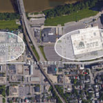
Part of Covington’s urban core that hasn’t seen any new residential development is the area north of 4th street between Madison Ave. and I-75. Dubbed “Hamburger Heaven” in the city’s recent City Center Action plan, it contains multiple fast food restaurants, the sprawling one-story IRS center, and a sea of parking lots. Part of the reason the area hasn’t seen any development is that Covington’s 4th Street delivers 27,000+ cars per day to I-75. That much traffic is incompatible with pedestrian-friendly urban space.
The City Center Action Plan makes redevelopment of the Hamburger Heaven and IRS sites a priority but it does not address the area’s inhospitable traffic. It’s a problem: How do you connect new development north of 4th street to the existing pedestrian-friendly urban fabric while maintaining all the traffic to the interstate?
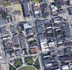
Figure 3: Octavia Boulevard, 2016, courtesy of Google Earth
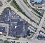
Figure 2: San Francisco’s Octavia Street in 1987, courtesy of Google Earth
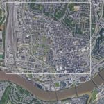
Figure 1: Covington’s 4th Street, IRS building, and Hamburger Heaven area
The imminent closure of the IRS site presents an opportunity to address the problem. The 23-acre site covers 3-1/2 blocks of frontage on 4th street. Most of the remaining space adjacent to 4th street between the IRS site and I-75 consists of parking lots.
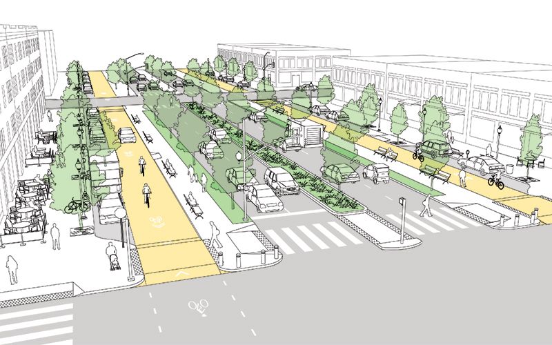
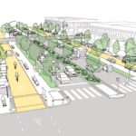
Once the IRS site is closed, the city of Covington should widen 4th street and convert it into a multiway boulevard.
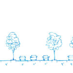
A multiway boulevard consists of a series of central lanes to move through-traffic, side lanes with on-street parking to serve local vehicles and bicycles, and broad sidewalks to serve pedestrians. Tree-lined medians separate the local traffic from through-traffic, and trees on the sidewalk further separate pedestrians from traffic. Think of it as a “mixed-use street.” Because the street supports a different mix of uses – people, bicycles, transit, through traffic – it can more readily support mixed-use buildings at its edges. Mixed-use buildings add the density and diversity of uses that support pedestrian-friendly urban space.
San Francisco recently took an existing street and converted a portion of it into a new multiway boulevard. The creation of Octavia Boulevard was possible because an earthquake damaged a freeway and made it unusable. Instead of rebuilding the freeway, San Francisco added its right-of-way to a four-block stretch of Octavia Street, which became Octavia Boulevard.
Today, Octavia Boulevard moves 45,000 cars per day in two directions, it has side streets and broad sidewalks to serve local residents, and the creation of the street spurred new development on its edges. Octavia Boulevard sets a clear precedent for converting underutilized auto-oriented development into more productive mixed-use urban development. Octavia Boulevard is aesthetically pleasing, practical at moving traffic, and successful at promoting economic development.
To implement Covington’s “4th Street Boulevard Project” the street’s existing 50-foot right-of-way would be widened to the north to create a 100+ foot wide right-of-way.
The expanded right-of-way will accommodate the multiway boulevard’s additional lanes, medians, and sidewalks. Expanding the right-of-way will require part of the IRS parcel, a number of parking lots, and the demolition of a fast food chain restaurant.
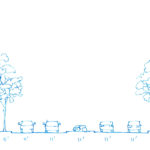
Figure 4: Proposed 4th Street Boulevard with 110’ right-of-way and three lanes of one-way through traffic
Figure 5: 4th Street Boulevard with 125′ right-of-way, four lanes of two-way through traffic, and a center median
Figure 6: Conceptual rendering of a multiway boulevard. Image via the National Association of City Transportation Officials
Different design options could include making 4th street’s through lanes either one-way or two-way. A dedicated transit lane could be accommodated. Bicycles can share the local lanes with local vehicular traffic.
Implementing the 4th Street Boulevard Project would have multiple effects that support the ongoing urban renaissance. The medians and parked cars provide protection for people to walk, eat, drink, and socialize outside. Trees also protect pedestrians and provide a canopy for shade and cooling. Bicycle use will be safe and easy. Converting 4th street from a single use – channeling cars to I-75 – into a multiway boulevard will facilitate the development of dense mixed-use buildings.
There’s a historic opportunity here. The IRS site was born out of federal urban renewal projects in the 1950s. Its time is now at an end. The trend of the future is to live, work, and play in the urban core. The current traffic on 4th street is a barrier to urban development. Converting 4th street into a multi-way boulevard will support the traffic flow but mitigate its negative impacts. Recent examples provide good evidence.
If the ongoing urban development is to be sustained and space north of 4th street – just blocks away from the Ohio River – is to be put to its highest and best use, then the traffic along 4th street must be addressed. Converting 4th street into a multiway boulevard will do just that.
This is a guest editorial by Chris Meyer that originally appeared in the CNU Midwest blog. CNU and CNU Midwest are content partners with UrbanCincy.
If you would like to have your thoughts and opinions published on UrbanCincy, simply contact us at editors@urbancincy.com.