Categories
Business Development News

Cincinnati Central Riverfront Plan wins national award for excellence

In 1997 officials from the City of Cincinnati and Hamilton County set out on a path to transform the city’s central riverfront. What became known as the Cincinnati Central Riverfront Plan laid out a bold vision to accomplish just that, and has now been recognized by the American Planning Association (APA) for the implementation of the plan first laid out nearly two decades ago.

The APA will present local leaders with the National Planning Excellence Award for Implementation at its annual conference to be held in Chicago on April 16.

“The Cincinnati Central Riverfront redevelopment is an excellent example of plan brought to reality,” Ann C. Bagley, 2013 APA Awards Jury chair, stated in a prepared release. “The fact that this development happened during an economic downturn demonstrates the strength of the plan and the importance of the public commitment that brought it into being.”


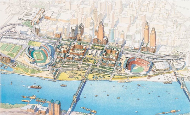
Cincinnati’s central riverfront has shifted dramatically from its form in the 1980s [LEFT], to that of the 2010s [RIGHT].

Local leaders have taken an incremental approach towards implementing the vision laid out in the Cincinnati Central Riverfront Plan. Between 1998 and 2002, the first major investments included the reconstruction Fort Washington Way (FWW), and the development of Paul Brown Stadium, Great American Ball Park, and the National Underground Railroad Freedom Center.

The consolidated FWW opened up dozens of acres of waterfront property, and the development of two stadiums and a major museum were intended to serve as cultural and entertainment anchors that would draw Cincinnatians back to the riverfront.

These significant public investments laid a critical foundation that would enable the next phase of work, historically located in one of the most flood-prone areas of the city, out of the 500-year floodplain.

Once a private development team had been selected, the City of Cincinnati and Hamilton County began to work with Carter-Dawson on the construction of the plan’s most ambitious element known as The Banks.


Phase two of The Banks will deliver another 300 residential units along with more than 60,000 square feet of commercial space, and a future office tower.

The $91 million first phase of the mixed-use development began in 2007 and resulted in 300 apartments, 76,000 square feet of commercial space, and 6,000 structured parking spaces. Emboldened by the success of phase one, developers are set to break ground on phase two in the coming months which will include another 300 residential units and more than 60,000 square feet of commercial space.

Two office towers, a hotel and townhomes are still to come within the first two phases of The Banks. At ultimate build out, officials envision The Banks to result in $600 million worth of private investment and become the home for more than 3,000 residents.

Meanwhile, construction of the $120 million, 45-acre Smale Riverfront Park is progressing concurrently with the development of The Banks. To date, the first phase of the new central riverfront park has been completed and work is beginning on phase two. Future phases will be timed with future construction of The Banks, and as funding is allocated.

“In planning terms, a project that goes from a concept to implementation in less than 20 years is impressive to say the least,” stated Todd Kinskey, Executive Director of the Hamilton County Regional Planning Commission. “It is that much more impressive because, in this case, the implementation involved seemingly insurmountable physical, economic, and political barriers.”

The early discussions surrounding The Banks, however, were tumultuous at best as local leaders grappled with complaints about too much office space being introduced into an already competitive marketplace.


The original vision of the Cincinnati Central Riverfront Plan [LEFT] included more traditional types of architecture with greater use of natural building materials [RIGHT].

“The current plan to include 30-story buildings along the riverfront would harm downtown and violate the riverfront plans adopted by the community many years ago,” then Councilman Jeff Berding (D) told the Business Courier in 2007. “We need to remember that the plan adopted several years ago was not simply pulled out of the air, but was the result of intense public input and driven by professional urban planners.”

While design elements may not be of the same caliber as those originally envisioned, the urban form of the private investment appears to be as desired. But even more gratifying than that, for many of the early people involved in the planning, it is that the project has happened against all odds and skeptics.

“The successful implementation of the plan is the result of unprecedented cooperation between the city, the county and their partners,” exclaimed Vice Mayor Qualls (C), who was one of the original driving forces behind the development of the Cincinnati Central Riverfront Plan.

Her thoughts were further validated when Bagley concluded, “The fact that this development happened during an economic downturn demonstrates the strength of the plan and the importance of the public commitment that brought it into being.”

In addition to the future phases of the Smale Riverfront Park and The Banks, city leaders are now soliciting ideas for how to cap a 300-foot span of FWW. City and county officials say that the work to cap the short stretch of interstate will commence once a design is in place, and funding has been secured.

In 2010, UrbanCincy published an exclusive threepart series profiling the dramatic transformation of Cincinnati’s central riverfront over the past two decades.

Categories
Business News Transportation

Following Zipcar’s Cincinnati expansion, car-sharing company acquired by Avis

Just 49 days after Zipcar announced that it would expand its services in Cincinnati, the car-sharing company announced that it had struck a deal to be purchased for $491.2 million by Avis.

The move by Avis, into the car-sharing sector, follows those of Enterprise and Hertz, and is seen as a critical evolutionary step for the traditional car rental company.

As the nation’s largest car-sharing company with more than 760,000 members, Zipcar offers its customers a way to move about urban environments without needing to own a car. Their slogan – “Wheels when you need them” – has increasingly hit home with young people that have been migrating back towards urban centers and ditching their cars.


A Zipcar on 12th Street in between Vine and Race Streets. Photograph by Randy Simes for UrbanCincy.

According to the U.S. Department of Transportation (DOT), overall vehicle-miles traveled (VMT) have reached their lowest levels since 2003, and that per capita VMT to levels not seen since 1998.

Furthermore, the University of Michigan Transportation Research Institute has found that teenagers are delaying the pursuit of getting their driver’s license with just 31 percent of 16-year-olds getting their driver’s license in 2008.

“By combining with Zipcar, we will significantly increase our growth potential, both in the United States and internationally, and will position our company to better serve a greater variety of consumer and commercial transportation needs,” said Ronald L. Nelson, Avis Budget Group chairman and chief executive officer. “We see car sharing as highly complementary to traditional car rental, with rapid growth potential and representing a scalable opportunity for us as a combined company.”

While car-sharing continues to see explosive growth locally and nationally, now estimated to be a $400 million industry, it is yet to be seen what the merger will mean to car-sharing customers wary of getting behind the wheel of a “traditional” car rental company.

Wrote Adam Richardson in the Harvard Business Review, “Any time an incumbent acquires a disruptor there are challenges, and in this case, they stem from the very core of Zipcar’s existence: how it has created a sense of community with its customers and how it has used technology to create a scalable user experience that its customers love.”

Naturally, Zipcar leadership expects bright days ahead with more cars at more locations, new service offerings, and similar levels of service.

“This is a major win for Zipsters around the world,” Zipcar management wrote in an e-mail distributed to its customers. “With the global footprint, backing, and talented leadership of Avis, we’re going to step on the gas.”

Car-sharing has been available in Cincinnati since 2011. Rates start at $8.50 per hour, and 11 cars are available at five different locations in the Central Business District, Over-the-Rhine, Clifton Heights and Corryville.

Categories
Business News Transportation

Nate Wessel aiming to change the way Cincinnati does maps

Maps are used in our everyday lives to help us navigate our cities, perform research, and visualize spatial data, but Nate Wessel has attempted to change the way Cincinnatians view such information.

In June 2011, Wessel started a modest Kickstarter campaign that would raise money to print a transit frequency map he had developed. Instead of using the typical approach to developing a bus system map, Wessel adjusted colors and line weights according to the frequency of service along each bus route.


Cincinnati Frequent Transit Map (Day Time). Image provided by Nate Wessel.

While he simplified the system map, he also added critical wayfinding information such as neighborhood business districts, parks, neighborhoods and natural landscape features.

“The maps used currently will put the 38X on the same visual level as the 17, but one runs three times a day in each direction, and the other runs almost 100 times a day in each direction,” Wessel explained. “In no way does the map indicate any more value for one over the other, but my map gives people an approximate idea of how long you’ll need to wait, in addition to how frequent the buses come and where they go.”

Wessel grew up in Northeast Ohio and said that his first experience with transit was biking a mile to an unmarked bus stop in Canton. Since then he has studied urban planning at the University of Cincinnati (UC) and worked with the U.S. Department of Transportation, Bureau of Transportation Statistics.

It was during his time at UC, when he realized something needed to change with the way transit information is visually presented.

“A friend of mine from China was basically saying that he felt trapped in his apartment, and didn’t know anything beyond campus and thought you could take transit, but didn’t know where it went,” recalled Wessel. “He lived in a transit-rich area, but many people like him didn’t know the correct routes to take to the right places, even easily accessible places like downtown.”


Hamilton County property values by square foot. Image provided by Nate Wessel.

The initial Kickstarter campaign raised far more money that Wessel was anticipated, and he was able to print and distribute 30,000 copies of his Cincinnati Transit Frequency Map. The map is now also featured on Southwest Ohio Regional Transit Authority’s (SORTA) website, but beyond that has not made significant inroads with regional transportation agencies.

Six months after Wessel distributed his new map, SORTA released a new regional transit map, for which they paid $20,000, that lacked the intuitive display and added information presented on the Cincinnati Transit Frequency Map.

While both SORTA and the Transit Authority of Northern Kentucky (TANK) were originally cooperative, and even contributed financially to the Kickstarter campaign, the follow-up, Wessel says, has been a bit disappointing.

Since the original release and distribution of the frequency map, Wessel has continued to improve upon it while also developing a separate night-time map, and one that focuses on center city transit service. To support those efforts, he launched a second Kickstarter campaign which funded the production of 20,000 additional maps in September 2012.

Wessel, however, has not limited himself solely to transit maps. He has released a number of maps this year that have highlighted property value data in Hamilton County, provided an exhaustive analysis of SORTA’s new transit plan, explained the theory of bus bunching, and is in the midst of an eight-part series critiquing the Cincinnati Streetcar project.

In the future he hopes to do a comprehensive map for bicycling to replace the existing one produced by the OKI Regional Council of Governments (OKI).

“In some way it’s a common interest in Cincinnati that I share with a lot of people that see the city not doing things as awesome as compared to other places, so I kind of want to do that with information about transit and cartography,” Wessel explained. “I also want people to make informed decisions about transit and planning in general, and I think that putting as much information out there in an attractive and useful manner helps.”

Nate Wessel was the winner of UrbanCincy’s first featured profile contest at the September 2012 URBANexchange. If you have a great idea we should know about, please contact the us at urbancincy@gmail.com. URBANexchange events are held on the first Wednesday of every month at the Moerlein Lager House.

Categories
Business Development News Opinion

Large vacant buildings should be transitioned into urban community centers

Could the Bartlett Building be transformed into something completely different? Photograph by Thadd Fiala for UrbanCincy.

Throughout the United States there are cities that have large vacant buildings and spaces in their central business district that could be utilized in a new efficient way.

In Cincinnati, the old School for the Creative & Performing Arts was recently auctioned off and is slated to be turned into apartments. In the CBD the Bartlett Building, Tower Place Mall, and Terrace Plaza Hotel remain empty or nearly empty and take up about one-fourth of a city block each.

Some think these buildings could be prime residential properties, but they could be that and more. A large vacant building, for example, could be developed into a mixed use community center.

My inspiration actually came from the Up To Speed story on UrbanCincy about a rock climbing gym in St. Louis. I thought to myself that Cincinnati can have something similar and better. Downtown Cincinnati and OTR/Pendleton are becoming destinations for young adults and families for both restaurants and bars.

Turning a large vacant building into a destination point for physical and social activity would add a whole new dimension to the city. The following ideas are what could go collectively into a large empty building:

  • Rock Climbing Gym – With the exception of the UC recreation center, all of the rock climbing centers are on the outer edge of the city.
  • Paintball Arena – This would be an extremely unique idea for the area as there are minimal indoor paintball facilities and could be a draw for different work or teambuilding groups.
  • Exercise Gym/Running Track – The gyms downtown are mostly old and do not offer enough space or have odd floor plans. Renovating a vacant building would allow plenty of space with tall ceilings and large windows that could allow natural light and have a large open space for exercise equipment. A downtown gym with enough space can offer a full menu of classes including Crossfit, spinning, yoga and Zumba, to bring in a broad range of people looking to exercise. A running track a fraction of the size of an outdoor track could be installed for those that do not like treadmill, but want to run indoors.
  • Basketball Court/Indoor Soccer – Large office buildings could utilize a few stories to carve out a basketball/indoor soccer surface and hold leagues and practices for area schools and AAU teams.
  • Batting Cages/Pitching Tunnels – The basement of a building could be an ideal area for batting cages and pitching tunnels for baseball and softball practice during the cold months. These cages and tunnels are easily moved and can be repositioned to make room for more activities inside the building.
  • Golf Simulators/Nets/Putting Green – This would be another unique addition to an urban area with little green space for golf. Workers could play a quick round during their lunch break or warm up before they go out to one of Cincinnati or Hamilton County’s public courses. This would also allow for urban dwellers a space they could walk to for golf lessons.
  • Offices – With additional amenities a building would become more attractive to businesses.
  • Apartments – To make the building a true mixed use development, apartments could be added as this would be a true “luxury apartment” with a real gym (unlike those found at too many apartment complexes that only have a treadmill and Bowflex and call it a gym) and the ability to walk to some of the most popular dining destinations in the city.

To compare a potential community center downtown with other recreational centers, the Recreation & Physical Activity Center at Ohio State University has a total of 570,000 square feet of space including the pools, while 25,000 square feet is fitness space for weights and treadmills. By contrast, the Campus Recreation Center at the University of Cincinnati has 202,000 square feet including its pools.

The options of what to include in these large, empty spaces are endless, but a truly mixed use development would be better suited for the community than simply offices, apartments, and art studio space. The gyms downtown are old and do not offer enough space, or have odd floor plans. Rock climbing and paintball would draw younger crowds, and the students in the area could benefit from having additional practice facilities.

A neighborhood needs young families as well as young professionals. This would be a good start to try and draw them to the core and keep them there.

Brian Valerio grew up in Cincinnati’s College Hill neighborhood and graduated from St. Xavier High School and Ohio State University where he studied finance and real estate. He currently works at Fifth Third Bank and lives downtown. Those interested in sharing their thoughts can submit guest editorials to UrbanCincy by emailing urbancincy@gmail.com. Please include a short bio with any submissions.

Categories
Business Development News

Ohio awards nearly $9M in historic tax credits to seven Cincinnati-area projects

Seven Cincinnati-area developments have been awarded nearly $9 million in tax credits from the Ohio Development Services Agency (ODSA) through the state’s historic preservation program.

Six of the seven area projects are located within the City of Cincinnati, and one is located in downtown Hamilton. The Cincinnati-area projects took home nearly 25 percent of the total $35.9 million distributed in the program’s ninth round of funding, and will create more than 130 new housing units and tens of thousands of square feet of commercial space once completed.

“The Historic Preservation Tax Credit puts empty buildings back into the economic cycle, creating jobs through construction activities and reoccupation of the buildings,” Christiane Schmenk, director of the ODSA, stated in a prepared release. “This program saves some of the state’s most significant historic structures.”


Eden Park’s 118-year-old pump station may soon see new life as a micro-brewery thanks to a $1 million tax credit from the State of Ohio. Rendering provided.

According to state officials, projects receiving funding must complete the rehabilitation work in accordance with the U.S. Secretary of the Interior’s Standards for Rehabilitation before the credits are issued to the building owner or long-term tenant.

More than $3.3 million in funding will flow into Over-the-Rhine for Losantiville Apartments, Abington Flats, and Pendleton Apartments through the program, and the Cincinnati Center City Development Corporation (3CDC) was awarded $1.8 million for its $9 million redevelopment of three historic buildings at Third Street and Main Street in the central business district.

“Without it [Ohio Historic Tax Credit] we would be unable to preserve the historic character of as many buildings as we have,” Anastasia Mileham, 3CDC’s vice president of communications, told UrbanCincy. “The cost to restore and develop them costs more than the what you can sell the condos for and lease the commercial space for. Historic tax credits help fill that gap and make the math work.”

In Mt. Adams, the Cincinnati Beer Company was awarded $1 million for its $5.2 million project that will transform Eden Park’s 118-year-old pump station into a brewery and tap room. Nearby, the Walnut Hills Redevelopment Foundation and The Model Group were awarded $1.8 million to renovate three historic structures into 30 market-rate housing units and approximately 7,000 square feet of street-level commercial space.

Elsewhere, the City of Hamilton will see more than $800,000 go towards the renovation of the 126-year-old Hamilton Journal-News Building, which will become the home of Butler Tech’s School for the Arts and Hamilton City Schools’ Adult Basic & Literacy Education (ABLE) program.

According to ODSA, this round of funding will assist in the rehabilitation of 45 historic buildings throughout the state, and leverage more than $252 million in private investments.