Categories
Business News Transportation

Metro, Uber Ink Deal Aimed at Addressing First and Last Mile Connections for Transit Riders

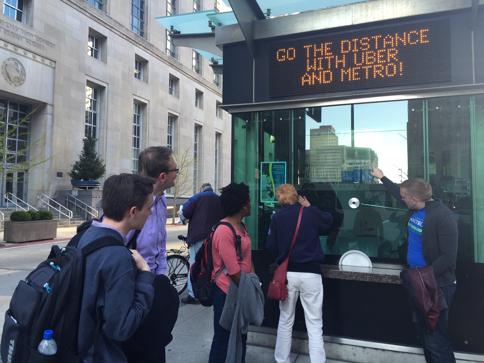
Business leaders from Uber and transit officials with the Southwest Ohio Regional Transit Authority gathered yesterday to announce a new partnership between the region’s largest transit provider and the increasingly omnipresent ridesharing service.

As part of the partnership, Metro will place interior transit cards on buses advertising a unique code that will offer a free ride to first-time Uber users. While the deal is similar to Uber’s many other marketing relationships, it may be the first step toward greater collaboration between the two organizations.

“Many of our customers have expressed their interest in using rideshare services like Uber in conjunction with their Metro trip to bridge the gap between service hours and locations,” Metro CEO & General Manager Dwight A. Ferrell said in a prepared release.

In other cities, like Dallas and Atlanta, Uber has partnered with regional transit agencies to integrate their mobile app with the route planning offered within the transit agency’s app. However, these relationships have been critiqued for what being a lopsided arrangement favoring the fast-growing tech company.

Other partnerships looking to address the first mile, last mile challenge have so far struggled to amount to much, but this has not stopped transit officials in Minneapolis and Los Angeles from inking deals to cover trip costs on Uber as part of their respective guaranteed ride home programs.

Such issues, however, are not deterring Metro officials from looking at the potential upsides that might come out of the partnership.

“We’ve seen the significant success Uber has had with other major public transit providers,” Ferrell stated. “We believe Uber is an ideal partner to help us meet the needs of our customers, ultimately making their experience as convenient and enjoyable as possible.”

If the partnership is successful, it could create significant value for Metro riders and help tackle one of the most difficult challenges facing transit agencies throughout North America – how to get riders to and from transit stations without the use of a personal automobile. Eliminating such a problem would allow many people to significantly reduce their reliance on a personal automobile, or eliminate it altogether.

Uber and Public Transit Pairing [FiveThirtyEight]

“Cincinnatians are already combining Uber and Metro to reach their destinations and we are excited to partner to spread the word further that Uber is an option to take Metro riders that ‘Last Mile,’” said Casey Verkamp, general manager of Uber Cincinnati.

Verkamp and Ferrell are right in being optimistic about the potential. An analysis by FiveThirtyEight found that people the combined cost of public transit and Uber becomes more cost effective than owning a personal automobile when the person uses public transit for approximately 85% of their trips and Uber for the rest.

With the average household making 2,000 trips annually, that equates to roughly 300 Uber trips per year. Of course, the average Cincinnatian takes far fewer than 1,700 trips per year on public transit, so a fully functioning arrangement of this kind would be hugely beneficial for both Uber and Metro. The main problem in Cincinnati is that the vast majority of people living in the region are not well-served by transit, and are essentially unable to take 85% of their annual trips by public transit.

Nevertheless, this is the first partnership of its kind in Ohio. While its limited scope leaves much unanswered about how it will benefit area transit riders over the long-term, it does illustrate that Metro officials are thinking about the future of how to move people effectively and efficiently throughout the region.

“This partnership exemplifies how cities like Cincinnati are embracing innovation and creative solutions to meet the needs of their residents,” Verkamp concluded.

Categories
Development News

Columbus is not the biggest city in Ohio, and Indy’s not bigger than Boston

Following the release of the U.S. Census Bureau’s updated population numbers for American cities, much has been made about the urban rise of the west. Even the Census Bureau itself touted the growing number of cities with more than 1 million people – the vast majority of which are located west of the Mississippi River.

These numbers can be misleading, and often don’t even pass the smell test.

Is Jacksonville, for example, really a bigger city than Detroit, Washington DC, Atlanta and Boston? Or out west, would most people actually consider Phoenix to be a larger city than San Francisco, Seattle, Denver or San Diego? Of course not.

In both scenarios, however, that is precisely the case. That is because the municipal boundaries for Jacksonville (885 square miles) and Phoenix (517 square miles) are disproportionately large compared to the population of their city. Closer to home the same is true for Columbus (223 square miles), Indianapolis (368 square miles) and Charlotte (298 square miles) – all of which skew the average population density for cities east of the Mississippi downward due to their huge municipal footprints.

If you were to simply pick-up a daily newspaper and read the listing of America’s most populated cities, you would not get this full perspective and perhaps be misled to think that Columbus is the biggest city in Ohio, or that Indianapolis is the fifth largest city east of the Mississippi River.

Using this same practice, some might consider Cincinnati to be a small city that doesn’t even crack the top 30 in the United States.

Of course, we know all of this is skewed by all sorts of factors. Some cities sit on state or county lines, others follow historical boundaries from hundreds of years ago that have never changed, while other are granted more liberal annexation capabilities. In short, it’s politics.

Now if we were to look at America’s 30 most populous cities again, but rank them by population density instead of overall population, the picture would change rather dramatically. Most cities in the west fall considerably, while older cities in the east would rise. The outliers that have artificially inflated their boundaries over the years also fall into a more normalized position on the chart.

While Cincinnati is not in the top 30 in terms of population, we considered it anyways since this is UrbanCincy after all. After adjusting for population density, Cincinnati would vault all the way to the 16th “biggest” city in America, just behind Denver and ahead of Dallas. This is also more in line with Cincinnati’s metropolitan population ranking that falls within the top 30 in America.

Those cities in this analysis that are in the east have an average population density, outliers included, of 6,579 people per square mile, while those in the west, come in at 3,804 people per square mile.

If outliers like Jacksonville actually were as large as they project, and followed the average population density for the region, it would need to add close to 5 million people. Likewise, Indianapolis would need to add around 1.6 million people and Charlotte 1.1 million. Local politics and market conditions in each of these cities will never allow for this many new people to move within city limits.

The Washington Post is correct in that the west is getting more populated and urbanizing at a fast pace, but let’s not get ahead of ourselves. The most populated cities in the west would only be average, at best, in the east if they were judged by population density instead.

Now, factoring for population-weighted density would be an entirely different ballgame.

Categories
News Opinion

CNU23: Unsure About Expectations, Dallas an Unexpected Delight

I saw my first cowboy hat within my first five steps off of my Frontier Airlines flight into Dallas/Fort Worth International Airport.

The truth is, I didn’t really know what to expect from Dallas – hell, I’d never even been to Texas. What I found during last week’s visit was a clean, cosmopolitan city filled with music, art, and a personable populace that exceeded my expectations.

Things didn’t get off to the best start. I had to spend a couple of hours at the airport waiting for my girlfriend’s flight to arrive. Leaving Terminal E for the train at Terminal A, the Terminal Link bus felt, indeed, terminal, as it would its way through an unintelligible maze of ramps and roadways.

We then faced another hour on Dallas Area Rapid Transit‘s (DART) Orange Line to our accommodations, the historic Hotel Lawrence in the West End of Dallas. I would not recommend this hotel unless you’re looking for something cheap and you’re not planning on being there much, because it’s currently under a heavy renovation to rebrand it as a LaQuinta Inn & Suites and won’t be completed until early next year. But it is served by several bus lines, is across the street from Dallas Union Station, and is a short walk from Dealey Plaza and the Sixth Floor Museum, which is located in the building from which President Kennedy was shot. Oh, and the 561-foot Reunion Tower (1978), where for $16 you can access the GeO-Deck. (I declined.)

(Tip: Buy a 7-day DART pass for $25 and enjoy unlimited rides on all trains and buses!)

I was in town for CNU23, which was being held downtown at the beautiful Hotel Adolphus (1912) on Commerce Street. The first two days were spent getting to know writers from other Streetsblog affiliate sites and brainstorming ways to build better stories, better sites, and a better national network. We also traveled to the adjacent Deep Ellum neighborhood, which, with its restaurants and bars, would be considered the city’s hipster enclave. While there, we heard a presentation on tactical urbanism and took part in a project to build seating out of reclaimed wood pallets for a street festival.

The rest of the conference – which was extremely well-run, by the way – was focused heavily on transportation and designing around transit. Called “Meeting the Demand For Walkable Places”, the conference featured speakers presenting on topics ranging from in-depth to broad, tours of place making initiatives that are working, and meet-ups.

I will say that the architecture in Dallas left me a bit wanting. Many of the downtown buildings are constructed in the modern/brutalist and postmodern styles, indicative of the postwar boom that saw the city grow from a population of under 300,000 in 1940 to an estimated 1.3 million today. But there are pockets of “old” Dallas here and there, and numerous public plazas from which to enjoy them.

(Note: Yes, there is a McDonald’s with a drive-thru in downtown Dallas!)

On the way back to the airport on Friday, I was able to get a good look at some transit-oriented development near the Orange Line’s Victory station (near the American Airlines Center) and the massive planned community of Las Colinas in neighboring Irving.

The airport was no better the next day.

I would definitely recommend Dallas. The people were fantastic, the food was great, and the positive vibe was palpable. It may have just been the great minds that were in town for the conference, but, if it’s even half as nice on a daily basis, I’d still enjoy it. And the “CVB” weather made it all the more enjoyable.

CNU24 will take place June 8-11, 2016 in Detroit. I’ve been to Detroit several times, but not for a few years. Perhaps it will be time to visit again.

Categories
News Transportation

CNU23: Conversation on Transit Should Focus on Access, Not Technology

The language we use when discussing transit is fundamentally flawed, according to Jarrett Walker, an international consultant on public transit design and policy and author of the book Human Transit.

Walker’s remarks were delivered at the CNU23 conference, which was held last week at Hotel Adolphus in downtown Dallas.

“The North American transit conversation is mostly using false binarisms,” Walker said.

Examples of this kind of “either this or that” thinking can be seen in debates over profit vs. subsidy, infrastructure vs. service, rail vs. bus, aesthetics vs. abundance, and choice riders vs. dependent riders, he said.

He also believes that too much of the conversation has been about technology and engineering, political wrangling, or how the system will be financed.

In doing so, we’re ignoring what should be transit’s goal: providing abundant access and expanding opportunities for all to enjoy the city’s riches. In other words, he said, we should be designing the transit network to maximize peoples’ liberty and opportunity.

Mariia Zimmerman, principal and founder of public policy consulting group MZ Strategies, agreed with Walker that too much of the discussion and advocacy surrounding transit is about the infrastructure itself.

She noted that such thinking has had the effect of the trickle of funding transit gets through the Federal Transit Administration being used almost entirely for buses, tracks, train cars and shelters, with precious little available for actual operation.

“Transit, at best, is the poor stepchild,” Zimmerman said. “In many cases, it’s the bastard. When we’re investing in the infrastructure instead of the operating, it’s tough. How can we sell and persuade people to support transit – outside of the infrastructure?”

Without access, there is no transit service, only symbolism, Walker said.

“One thing to know is that access leads overwhelmingly to ridership,” he said. “The idea that transit infrastructure has outcomes just by itself is a false analogy imported from buildings and highways.”

Walker quoted Alan Watts, the British-born philosopher, writer and speaker, who said that “Western cultures are prone to eat the wrapper and throw away the food.”

“This existing view of transit is all the wrapper,” he said. “The freedom and opportunity of people to access their city is the food.”

Categories
Up To Speed

Is the Great Lakes region ready to start acting like a megaregion?

Is the Great Lakes region ready to start acting like a megaregion?.

Only a small piece of land between Cincinnati and Dayton remains undeveloped, and many believe that remaining gap will disappear very soon. But the merging of Cincinnati and Dayton as one large metropolitan region is only part of the story, as shared regional identities with other large urban centers throughout the Great Lakes region becomes more pervasive. This and other regions like it around the U.S. are becoming even more centralized. More from The Week:

Though the concept has existed in academia for decades, planners are now looking at these dense corridors of population, businesses, and transportation and wondering if the megaregion may, in fact, be the next step in America’s evolution. With renewed interest and investment in urban centers and the projected growth of high speed rail, megaregions could easily become home to millions more Americans.

The Northeast corridor, for example, could receive up to 18 million more residents by 2050, according to estimates from the Regional Plan Association. And the region encompassing major cities in Texas including Houston and Dallas could see a spike from roughly 12 million to 18 million people in that same time, the association says.

And where population goes, economic growth is not far behind. The Northeast corridor would be the fifth largest economy in the world, with the Great Lakes megaregion at ninth and the Southern California megaregion outpacing Indonesia, Turkey, and the Netherlands as the 18th largest, according to 2012 estimates from real estate advisory RCLCO. The problem is, there are challenges to making these networks hold together. Unlike megaregions in Europe and Asia, for example, the United States has traditionally shied away from large umbrella governing organizations which surpass state borders.