Categories
Business News Politics

Comprehensive Study Needed to Examine Cincinnati’s Migration Problem

Cincinnati has a problem with attracting immigrants.

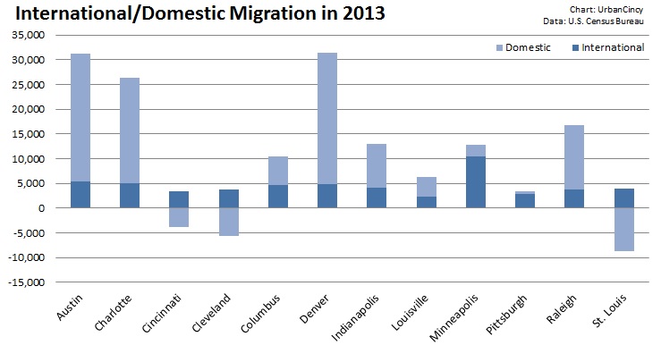
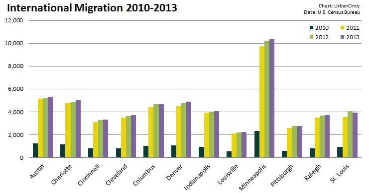
While it is the largest metropolitan region in Ohio, Cincinnati lags behind both Cleveland and Columbus in attracting foreign migrants. Even as Cleveland continues to lose population and struggles with a weak economy, Cincinnati, with its much stronger economy and national recognition, attracts fewer of America’s newest residents.

More alarmingly, at 4.6%, Cincinnati ranks behind all of its regional competitors (Columbus, Indianapolis, Louisville, Pittsburgh, St. Louis) in percentage of foreign-born population. Columbus (10.5%) and Indianapolis (8.4%) have double or nearly-double the percentage of foreign born population. Cincinnati only bests Pittsburgh and Louisville in terms of attracting immigrants over the past three years.

International Migration 2010-2013

The United States as a whole continues to attract millions of new immigrants. They’re just not coming to Cincinnati at the same rate as elsewhere.

Mayor John Cranley’s (D) recent announcement to start an initiative to grow the immigrant population in Cincinnati is a welcome one. With statistics showing that immigrants are more likely than non-immigrant Americans to start a business, a flux of foreign residents would be good for Cincinnati’s economy in more than one way.

Cranley is not unique among mayors in cities across the nation that have suffered massive population losses since the 1950s. From Baltimore and Philadelphia, to Detroit and Dayton, cities across the country are now targeting immigrant communities in order to help bolster populations and foster economic growth.

Preferably, Cincinnati’s quest to attract new immigrants will be part of a larger plan to attract new residents, period. While lagging behind in attracting immigrants, the region also continues to shed existing residents to other parts of the country.

International - Domestic Migration in 2013

Local leaders should authorize a comprehensive study to find out why Cincinnati struggles so greatly with attracting domestic and international migrants. With a growing economy and incredible regional assets, there is no reason why Cincinnati should fail so miserably at attracting new people.

It may prove wise to set city funds aside to create some sort of media blitz that touts the benefits of the city and the surrounding region. With a recent Gallup poll showing that 138 million people around the world would choose to move to the United States if given the opportunity, the market for new immigrants is surely present. Some sort of economic incentive would help as well. Tax breaks for immigrant businesses and incentives to live within city limits will help attract immigrants of all economic levels.

It is not a stretch to imagine that Columbus’ ability to attract and retain so many more immigrants than Cincinnati is due to the presence of Ohio State University, one of the nation’s most prominent public universities. As a result, Cranley should take heed and foster greater cooperation between the City of Cincinnati and the University of Cincinnati and Xavier University, using those nationally-recognized institutions to attract even more newcomers.

At the end of the day, however, immigration is a national issue. For that reason, regional leadership should be in active dialogue with Cincinnati’s Congressional delegation and lobby them to support immigration reform and initiatives that will help attract immigrants not just to the U.S. in general, but to the Cincinnati region specifically.

Categories
Business News

Take a Look at CVG’s Abandoned Concourse C Through Ronny Salerno’s Lens

Ronny Salerno has established himself as one of the region’s best photo journalists. He covers the stories not often given light in the typical news cycle. The stories he publishes on his website, Queen City Discovery, aren’t often current events, but they are always topical.

One of his more recent features that garnered national attention uncovered the history of a ghost ship left stranded downstream from Cincinnati in a small tributary to the Ohio River. Salerno has become well-known for his thoughtful coverage of abandoned buildings and their stories they hold.

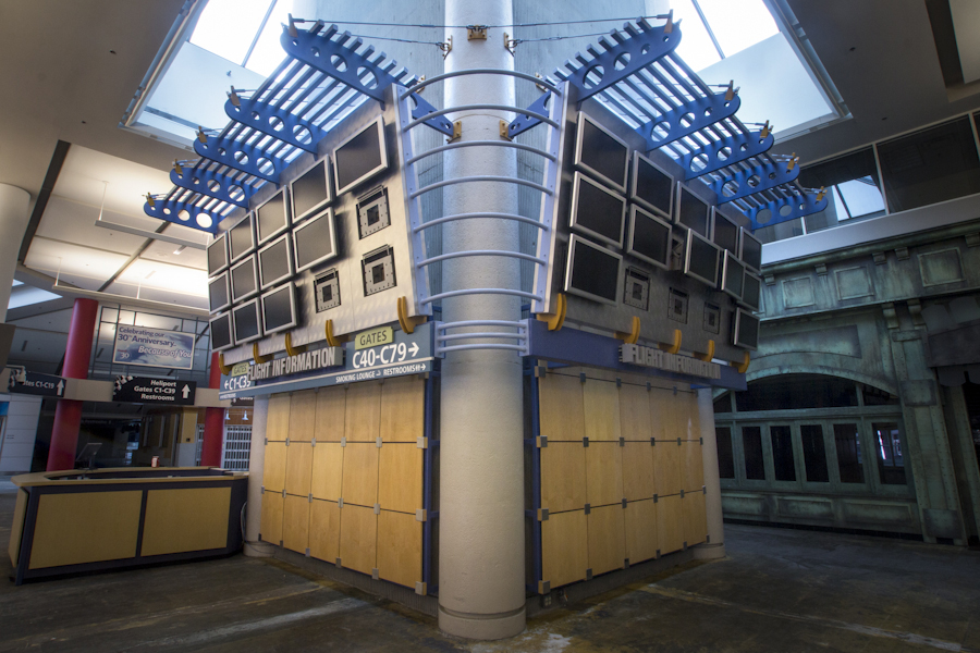
The most recent feature of his looks at the now abandoned Concourse C at the Cincinnati/Northern Kentucky International Airport (CVG). While Concourse C was once a symbol of CVG’s prominence and significance, it is now a visual reminder of how far the airline industry in general, and the airport in specific, have fallen over the past decade.

Regional air travel, which is what Concourse C catered to through its Comair service, is becoming more and more a thing of the past. Throughout Europe, China, Japan and Korea, where inter-city high speed rail is prevalent, regional air travel has already fallen by the wayside. In North America, inter-city bus travel has grown in popularity while Amtrak sets ridership records each year.

But still, no sign of comprehensive inter-city high speed rail seems to be anywhere in the near future for Canada and the United States. What will that mean for metropolitan regions with millions of people, like Pittsburgh, St. Louis, Cincinnati, and Cleveland, now being left off the map? Smaller regions, like Birmingham, already lack expansive air service and must rely on larger metropolitan regions nearby for service.

Many cities and regions are being left off the map and have fewer and fewer transportation options to get from one city to the next. Who knows what that will mean for these people and regions in the future, but for now please take a look back at the history and stories of CVG’s Concourse C.

The Concourse: Part 1 – Island in a Stream of Runways
The Concourse: Part 2 – Unaccompanied Minor
The Concourse: Part 3 – The Film (embedded above)

The fall of 1994 was a good time for regional airliner Comair, the company had just opened a second hub in its hometown at the Cincinnati/Northern Kentucky Regional Airport (CVG). Dubbed “Concourse C,” the building was an island in a stream of runways, accessible to passengers only via shuttle busses and the flights they arrived on. The concourse was always a center of human activity amongst the tarmac – featuring shops, eateries and over 50 gates to destinations across the continental United States.

It was a place where people reunited, strangers shared drinks between travels and employees fought the daily grind.

Comair was purchased by Delta Airlines in 2000 and both airlines plunged into bankruptcy protection by 2005. After emerging from bankruptcy in 2007, Delta began to scale back Comair flights and eventually relocated all operations to another section of the airport in 2008. Concourse C was left abandoned. In 2012, Delta completely folded Comair.

Today, Concourse C still remains out in the middle of the runways: no passengers, few visitors and closed off to the general public. It’s eerily quiet state is a stark contrast to the sea of humanity that once flowed through it. On a recent exclusive tour of the facility, I was able to make this short film in addition to several photographs.

Categories
Development News Transportation

UC Planning, Engineering Students Propose Hamilton Avenue BRT Corridor

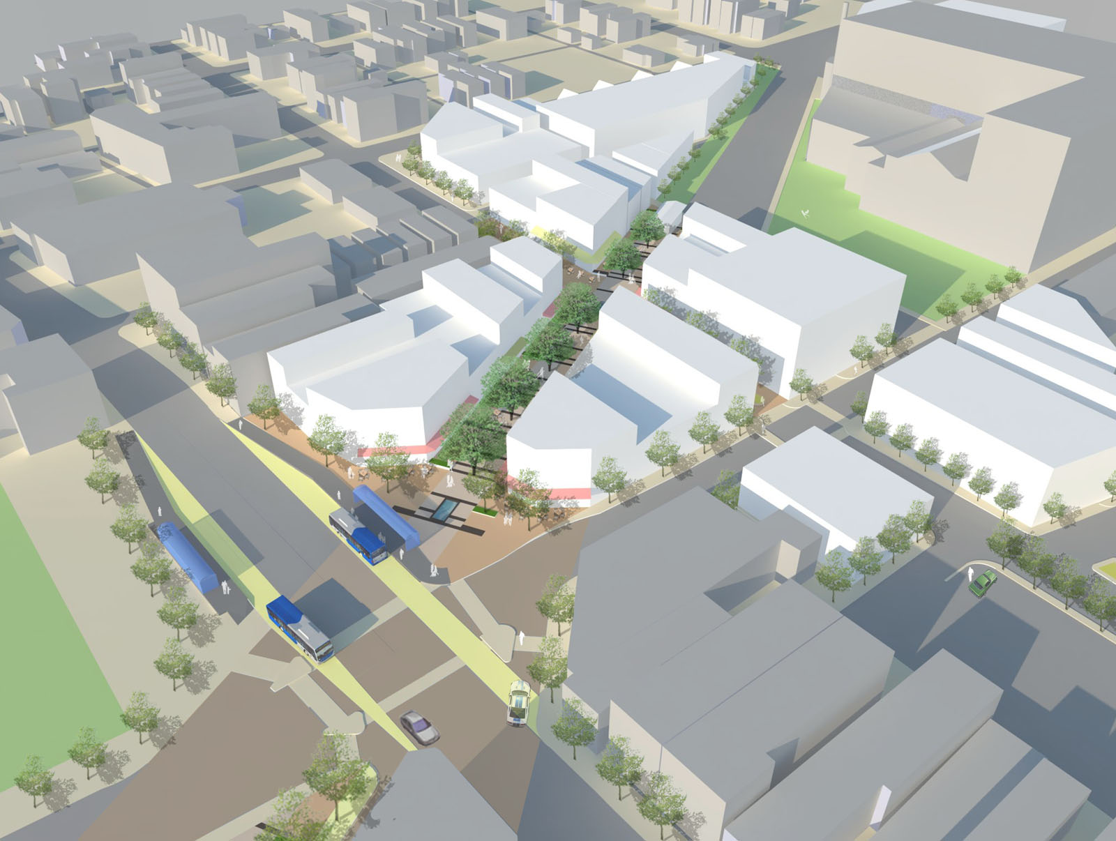
Hamilton Avenue BRT CorridorLast fall UrbanCincy partnered with the Niehoff Urban Studio on an event that highlighted the work of an interdisciplinary group of students. That semester engineering and planning students focused on urban mobility and looked at bikeways and bus rapid transit ideas within the city.

Each of the student groups presented their final research and findings to fellow academics and industry experts from around the region. We then gathered a group of transit and bike experts to engage in a panel discussion about the student’s proposals and about transportation in the region in general.

Throughout the course of the day, we asked members of the public who attended to vote on their favorite proposal. The winner was a bus rapid transit corridor along Hamilton Avenue that focused heavily on a transit-oriented development (TOD) in Northside where The Gantry is now being built.

The six-person team consisted of Tyler Kiefer, Benjamin Lafferty, Christopher Murphy, Michael Orth and Michael Walsh from the College of Engineering & Applied Science and Alexander Cassini from the College of Design, Architecture, Art & Planning.

First and foremost, the group said that their Hamilton BRT Line would most closely resemble Cleveland’s highly publicized HealthLine, which is the highest-rated BRT line, by far, in North America. The group also examined lines in Pittsburgh and Kansas City.

One of the main reasons for the comparisons to Cleveland is the similarities between the corridors. In both Cincinnati and Cleveland, the corridors connect neighborhoods under-served by transit to institutional services, while also providing greater mobility.

“The 2010 U.S. Census has shown how the population along Hamilton Avenue has less access to quick and reliable means of transportation when compared to the stats of Cincinnati and Ohio as a whole,” explained Masters of Community Planning student Alexander Cassini. “This lack of mobility directly affects citizens’ access to essential services and employment opportunities.”

Their research found that Metro’s #17 bus route, which most closely aligns with their proposed BRT corridor, currently averages weekday ridership of about 4,500 people. Furthermore, they found that approximately 17% of the households along the corridor have no car, 10% of the commuters identify as bus riders and there are 6,387 people living per square mile.

The proposed BRT corridor runs from Downtown to North College Hill, and the engineering and planning students saw this particular corridor as a major opportunity to spread investment and attention from the center city to additional neighborhoods that would take advantage of the BRT route’s 12 stations spaced out between one-half mile to three-fourths of a mile apart that would ensure faster and more efficient service. Each of the 12 station locations, Cassini notes, was selected due to its significant population and employment nearby.

“Northside and North College Hill are historic places in the city and present a great opportunity for Cincinnati to keep growing as a city,” noted civil engineering student Michael Orth.

Orth went on to say that while one of the positives of this corridor was the amount of people and businesses it could positively impact, the area’s congestion was also one of the team’s greatest challenges, stating, “There is very little room to implement a bus only lane throughout the corridor, which would be ideal for a BRT line.”

To help address this situation the group said that they envision a bus only lane, or a hybrid lane for buses and cars depending on the hour, through the congested portions of the route. Although not recommended, if a hybrid lane was determined to not be satisfactory Orth said that further study could be done to examine whether there would be enough benefit to remove on-street parking in order to provide for a consistent, dedicated bus only lane.

Other technology to help facilitate the quick movement of buses along the corridor would include arrival detection at traffic signals so that the lights can change in order to accommodate an approaching bus.

Existing Metro bus service, they said, would largely be redeployed to avoid redundancy, but some would remain since local buses stop more frequently – potentially creating a corridor of localized bus and express BRT service.

Hamilton Avenue BRT in Metro*Plus Context
One area where the Southwest Ohio Regional Transit Authority (SORTA) has already begun enhancing bus service is along Montgomery Road, which connects Downtown with the Kenwood area. That new Metro*Plus service, while not full BRT, is a step in the right direction according to the University of Cincinnati students, and has already seen ridership triple since its upgrade.

“Metro*Plus service is good but it is only the first step towards a true BRT system for the Cincinnati metropolitan area,” Cassini cautioned. “Metro*Plus service can be even more efficient, and effective if totally dedicated lanes and other additional features are added.”

Reading Road, where Metro began operating articulated buses in 2010, is actually the region’s most heavily utilized bus corridor with Hamilton Avenue coming in second and Montgomery Road third. If Metro is to continue to build out its enhanced bus service, or full-on BRT operations, then Hamilton Avenue may very well be the next logical choice.

What helped the group’s proposal stand out from other presentations was its focus on the TOD in Northside. With a $13 million mixed-use project coming out of the ground on that site now, the group reflected on their own proposal.

While the team had collectively noted the large, clean open space as being one of the huge benefits of the site, it also made it particularly valuable in their opinion. As a result, several of the group members, while encouraged about the private investment, were also a bit underwhelmed by the Indianapolis-based Milhaus Developers’ architectural design.

Both Cassini and Orth mentioned that they would be interested in working full-time in the transportation industry someday, but for different reasons. When asked to briefly compare the wide variety of transportation projects current in the planning or development stages around the region, there was a uniform response that their excitement is for the Cincinnati Streetcar.

“Although the planned streetcar line does not expand sufficiently in our eyes, we believe it would be an incredible economic development booster for Cincinnati’s downtown and overall urban core,” Cassini explained. “The overall transportation efforts around Cincinnati will eventually pay off to form a comprehensive and more easily navigable system than today.”

The Niehoff Urban Studio is currently working with a new set of students on designs for the Wasson Corridor, which runs through several of Cincinnati’s eastern neighborhoods. This is another topic that was examined by one of the interdisciplinary groups of planners and engineers last year. UrbanCincy is once again partnering with the Niehoff Urban Studio and will be organizing a similar showcase and panel discussion in 2014.
Categories
Up To Speed

What should a shrinking city do with its vacant housing stock?

What should a shrinking city do with its vacant housing stock?.

Losing population isn’t fun, and a host of cities throughout the U.S. have been losing population since their collective peaks in the 1950s. Cincinnati is one of those cities. Along with the troubling finances this presents, it also creates the predicament of deciding what to do with vacant households left behind. In Cincinnati, and many others, the decision has been to tear down homes and hope for something better. More from The New York Times:

A recent Brookings Institution study found that from 2000 to 2010 the number of vacant housing units nationally had increased by 4.5 million, or 44 percent. And a report by the University of California, Berkeley, determined that over the past 15 years, 130 cities, most with relatively small populations, have dissolved themselves, more than half the total ever recorded in the United States. The continuing struggles of former manufacturing centers have fundamentally altered urban planning, traditionally a discipline based on growth and expansion.

Categories
Business News Transportation

Industry Experts Believe a ‘Parking Revolution’ is Sweeping America

In April of this year, members of the International Parking Institute, the world’s largest association representing the parking industry, surveyed parking professionals to determine trends and gain input on parking and related topics.

The survey results found that a “parking revolution” is taking place in the United States, and that the industry is beginning to embrace a variety of new parking solutions.

“The industry is embracing a variety of new technologies that make it easier for people to find and pay for parking, and for parking authorities to better manage it,” the report stated.

Cities identified as leaders in the movement included San Francisco, Portland, New York City, Seattle, Miami, Houston, Boston, Denver, Pittsburgh, Washington D.C., and Tampa.

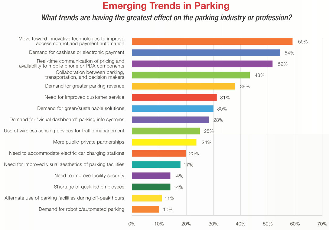
Emerging Parking Trends

Cincinnati’s recently approved Parking Modernization & Lease Program appears to apply these top trends by moving toward technologies that improve access control, payment automation, and real-time communication of pricing and availability to user’s mobile devices.

These kinds of features are the new standard being implemented around the country, and are provided by Cincinnati’s lease agreement.

Parking professionals were also asked to identify the ten most progressive municipal parking programs in the United States, with San Francisco’s SFpark named most innovative.

“The SFpark pilot project provides real-time information on parking availability and cost; reduces double parking, circling, and congestion; and improves parking ease and convenience,” the report stated. “A high-caliber data management tool allows the San Francisco County Transportation Authority to make rate-change recommendations, supply real-time data, maintain optimum operational and contractual control, and rigorously evaluate the pilot’s various components.”

Respondents also said that SFpark was particularly bold in requiring city and government employees to pay for parking in order to bolster the program’s credibility before asking voters to consider sweeping changes in parking management.

Of particular interest is SFpark’s on-street rate adjustment policy.

Prior to the changes, rate adjustments were made during the budget-planning process. The goal with the pilot program is to take a demand-based approach in order to achieve parking availability targets in a consistent, simple and transparent manner.

Prior to the program, rates in downtown were $3.50/hour, $3.00/hour in the downtown periphery and $2.00/hour in neighborhood commercial districts, and were operational mostly from 7am to 6pm or 9am to 6pm Monday through Saturday. As part of the pilot program, demand responsive time-of-day pricing is split into three distinct rate periods: 9am to 12pm, 12pm to 3pm, and 3pm to 6pm for 9am to 6pm spaces.

These demand-responsive rate changes are made gradually, no more than once per month, and periodically near the first of the month based on occupancy in the previous month.

In order to maintain at least one parking space per block, 80% space occupancy is desired with rates increased when occupancy is greater than 80%, held constant at 60% to 80% and decreased with less than 60% occupancy on a per-block basis to more effectively redistribute parking demand.

In order to help users from having to cut trips short or risk parking tickets, time limits in the pilot areas were lengthened from 30 minutes/two hours to four hours/no limit.

Cincinnati’s program, meanwhile, will provide for public rate control and expanded hours of operation from 8am to 9pm in the Central Business District and 7am to 9pm in neighborhoods. The plan will also allow for limited $0.25 incremental rate increases, but there does not appear to be provisions for demand responsive time of day pricing, a target on-street block occupancy amount, or lengthened or eliminated time limits.

In addition to new technologies, the report indicates that parking is becoming more than just a place to store cars, and is instead moving towards more integrated forms of transportation planning – something that has also taken place locally through new bicycle parking provisions and parking requirement restructuring.

“Today, parking is about so much more than storing cars,” concluded Shawn Conrad, executive director for the International Parking Institute. “It’s central to the creation of livable, walkable communities. It’s about cars, bikes, mass transit, mobility, and connecting people to places.”