Categories
Development News Politics Transportation

OKI Survey Results Show Preference for Compact, Walkable Communities

The OKI Regional Council of Governments has released the findings from its 2012 How Do We Grow From Here survey, and is reporting a record response.

According to OKI officials, the survey received 2,474 responses and more than 1,200 comments. In the past, the organization had received around 100 responses for similar surveys, but was hoping for higher numbers this time around due to a larger outreach effort.

The survey is intended to take the pulse of the Cincinnati region with regards to regional vitality, sustainability, and competitiveness with a special focus on land use and transportation policy. The results of the survey are then intended to be used when updating the metropolitan planning organization’s Strategic Regional Policy Plan (SRPP), which was last updated in 2005.

OKI 2012 Survey Results

“While much has been accomplished since the plan’s adoption in 2005, much remains to be done to reach its goals,” state OKI officials. “The SRPP needs to be updated to reflect the impacts of subsequent events such as the Great Recession and significant changes in our demographics, particularly as the baby-boom generation ages.”

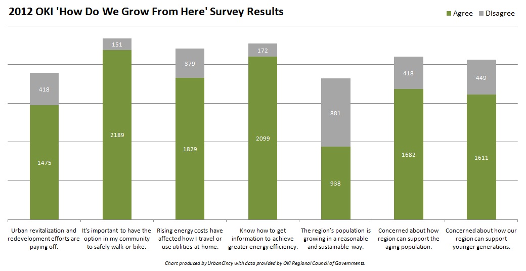
Of the survey’s 21 total questions, seven offered particularly revealing insights into the psyche of those from around the region concerning transportation options, economic development strategies, and land use policy.

The survey results indicate a clear preference for sustainable and urban communities. Approximately 60% of respondents said that they felt urban revitalization and neighborhood redevelopment efforts are paying off, and a whopping 88.5% said that it is important to have safe pedestrian and bicycling options in their community.

While the 2,474 respondents stated that they wanted to see existing infrastructure maintained and their communities built in a way to support walking and bicycling, it does not appear that they feel the region is heading in that direction.

“Bicycle infrastructure can play a big role in enhancing public health, providing additional options for transportation, and reducing pollution,” commented one responder. “I also would support a comprehensive transportation plan that includes the extended streetcar line and light rail. This could reduce traffic congestion and pollution and enhance economic growth for our neighborhoods.”

More than a third of those responding said that they feel the region is growing in an unsustainable manner, and more than two-thirds expressed concern about how the region’s housing, transportation, healthcare, and recreation options will support aging individuals and younger generations that desire walkable urban communities.

A 2011 report from Transportation For America found that more than 64% of Cincinnati’s population between the ages of 65 and 79 will have poor transit access by 2015 – ranking the region as the 17th worst out of 48 regions with 1-3 million people.

When asked about energy and the climate, approximately 74% said that rising energy costs have impacted their lifestyle choices surrounding transportation and utilities. With nearly 85% of those same respondents feeling confident about knowing where to go to get more information or help to achieve greater energy efficiency, it appears that organizations like the Greater Cincinnati Energy Alliance are making a positive impact.

“OKI needs to develop renewable energy sources for our area and eliminate all fossil fuel usage in the next 10 years,” responded one individual on the survey. “OKI needs to actively promote the Greater Cincinnati Energy Alliance that has enough funding to upgrade close to 70,000 homes and business in the Hamilton County and northern Kentucky.”

OKI officials state that while they currently have no authority, and seek no authority, over local land use decisions, they hope that the results of their updated SRPP will bring about more consistency between local land use planning and regional transportation planning.

On episode two of The UrbanCincy Podcast we discussed the issue of transportation poverty facing Cincinnati’s aging population, and how unsustainable development patterns are hurting the region’s environment and economy. You can stream our bi-weekly podcasts online for free, or download the podcasts on iTunes.
Categories
Development News Transportation

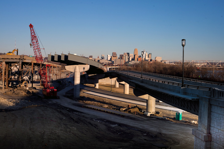
PHOTOS: $55M Waldvogel Viaduct reconstruction nearing completion

The reconstruction of the Waldvogel Viaduct was spared from the massive spending cuts at the Ohio Department of Transportation (ODOT) last January, and has been able to continue on its scheduled path.

According to City of Cincinnati officials, the project will replace the existing, half-mile structure that connects the Sixth Street Expressway to Elberon Avenue, Warsaw Avenue and River Road in Lower Price Hill and Queensgate. The existing structure had been deteriorating at a rapid pace, and had been rated in “Poor” condition for several years leading up to the project.

The $55 million Waldvogel Viaduct reconstruction project is also preserving space for a future bicycle / pedestrian path planned for Cincinnati’s western riverfront.

As of this month, very little remains of the 73-year-old elevated roadway. UrbanCincy contributor, Jake Mecklenborg, visited the construction site last week to capture the visual progress being made in Lower Price Hill.

Categories
News Transportation

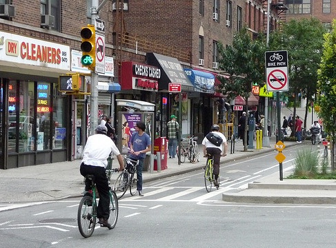
City officials working to get Central Parkway back on [cycle] track

There had been hopes to build the region’s first cycle track, a fully separated bicycle facility, on Central Parkway in 2012. Internal disputes and the lack of funding, however, have delayed the project’s implementation.

The Department of Transportation & Engineering (DOTE) gave City Council’s Major Transportation and Infrastructure Projects Subcommittee an update on the project, in addition to the other bicycle investments being advanced, last week.

At that meeting, Mel McVay, Senior City Planner with the DOTE, stated that the Central Parkway cycle track efforts were in the preliminary investigation stage, but that there could be some challenges regarding the facility’s relationship to vehicular capacity and on-street parking along the 3.4-mile stretch of roadway.

The full length of the cycle track would extend from Ludlow Avenue, where the City installed the region’s first green bike lanes in November 2012, to Liberty Street in Over-the-Rhine, and would cost approximately $750,000.

Plans for the Central Parkway cycle track first came to light during episode eight of The UrbanCincy Podcast.

The hope now, McVay says, is to finish the preliminary analysis within the next month. Should that analysis show it feasible to finance and construct the Central Parkway cycle track, then design work would begin immediately.

The City’s Bicycle Transportation Program has installed nearly 40 miles of bicycle facilities to-date, with an additional 289.9 miles planned in a citywide bicycle network.

Categories
Up To Speed

How Capital Bikeshare got started, and what Cincinnati can learn

How Capital Bikeshare got started, and what Cincinnati can learn from it.

What Washington D.C. has done with Capital Bikeshare is considered the nation’s best. It is the biggest, has the most riders, and is the most financially solvent as compared to the rest of the bike sharing systems in the United States. As Cincinnati prepares to launch its own bike sharing system, what can local leaders learn from the nation’s best system? More from Slate:

If you had been handed, a decade ago, a map of the U.S. and asked to predict where the novel idea of bike sharing—then limited to a few small-scale projects in a handful of European cities, might first find its firmest footing, you probably would have laid your money on a progressive hub like Portland or Seattle or the regional poles of walkable urbanism, New York or San Francisco—all of which were scoring higher, those days, in surveys like Bicycling magazine’s list of most bikeable cities.

Launching a sponsorless bike-share system intended to break even, or even make money, was unprecedented. And having no sponsor made raising capital a challenge, but D.C.-area governments scavenged for the money.

Categories
Up To Speed

NYC’s Queens neighborhood aiming to transform stretch of railway into park

NYC’s Queens neighborhood aiming to transform stretch of railway into park.

The dramatic transformation of the High Line in Manhattan has been so successful that it has influenced other urban communities to re-examine what they’re doing with their unused railroads. Just across the East River, however, Queens is aiming to transform a stretch of train track, that has been abandoned for 50 years, into what advocates are calling the QueensWay. More from the New York Times:

Now, the three-and-a-half-mile stretch of rusty train track in central Queens is being reconceived as the “QueensWay,” a would-be linear park for walkers and bicyclists in an area desperate for more parkland and, with the potential for art installations, performances and adjacent restaurants, a draw for tourists interested in sampling the famously diverse borough.

Unlike the High Line, the QueensWay would welcome bicycles. While the trestles are relatively narrow, long stretches are wide enough — up to 25 feet — to accommodate walkers and bicyclists. New bike paths could connect the park to Flushing Meadows-Corona Park to the north, as well as an existing bikeway in Jamaica Bay to the south. About 250,000 residents live within a mile of the proposed park, and its backers see all kinds of ancillary benefits, from health to traffic.