Categories
News Transportation

VIDEO: The Easy and Inexpensive Way For Cincinnati To Make Its Streets Safer

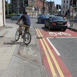
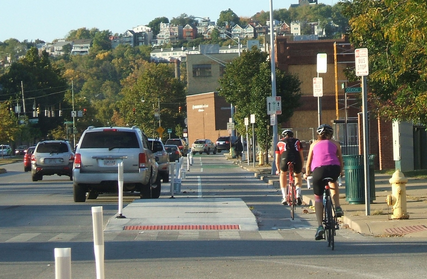
Anyone who rides a bicycle to work, either their own or on a Cincy Red Bike, knows all to well the commute mostly involves sharing the road with automobiles. With the current city administration focusing more on creating recreational trails for bicycle hobbyists, cyclists who bike as a form of transportation can only daydream about better on-street bicycle infrastructure.

That daydream could come closer to reality with the release of a new animation from planner and author Jeff Speck.

An accomplished author of books such as Walkable City and Suburban Nation, Speck describes four simple street reconfiguration options that would better accommodate all modes of transportation without adding to the roadway’s width. In order to accomplish that, the techniques include narrowing lanes, adding striped or buffered bike lanes.

Planners and engineers have found that such changes have a minimal impact on the flow of vehicular traffic, by adding only seconds onto commute times.

The street in the video is 38 to 40 feet in width, which is just about the average width of many streets throughout Cincinnati. In fact, UrbanCincy proposed a similar reconfiguration of Elm Street through the Central Business District in 2013. Such transformations have been noted to positively impact safety.

“Such a change on Prospect Park West in Brooklyn reduced speeding by 77% and reduced injury crashes by 63%, while having no impact on car volume or travel times,” Speck noted in the video.

When Randy Simes first wrote about the Elm Street reconfiguration, he explained that it would also serve as a critical connection point between the protected bike lane on Central Parkway and the Ohio River Trail. While Elm Street is a particularly obvious choice, other streets throughout the city could and should get some of the same treatment.

One another prominent example is Liberty Street, which Cincinnati’s Department of Transportation & Engineering has been looking at for years as a potential road diet candidate. Originally designed for much higher traffic volumes that were never realized, Liberty Street’s 70-foot width now functions more as a safety issue for people walking or biking, and as a barrier between the northern and southern portions of Over-the-Rhine.

Those plans for Liberty Street were originally envisioned by the Over-the-Rhine Brewery District, which then convinced City Hall to perform some planning work. At this time, however, the project does not appear to be moving forward.

Speck’s video makes it easy to see that for the cost of paint it would be relatively easy to install a more comprehensive bike network on streets throughout the city. Such changes would improve safety, increase the number of people riding bikes, which probably means more Red Bike usage, all while slowing down traffic just a tiny bit. Besides, even automobile drivers may appreciate not needing to directly interact with so many bicycles on the street.

Categories
Arts & Entertainment News

Record Crowd at Niehoff for Burnet Woods

Over one hundred and fifty people gathered at the Niehoff Urban Design Studios in Corryville to see and hear what University of Cincinnati design students had come up with on a reimagining of Burnet Woods. The Woods, which once included the land that is now the University’s west campus, is still one of the largest parks in the Cincinnati Park system and also the central focal point of three Cincinnati neighborhoods.

Both Masters and Bachlors degree students from the School of Planning at DAAP focused on the park as part of a year long planning effort coordinated by the City of Cincinnati and the university to envision a revitalized Burnet Woods.  A recent study conducted by the university polled 2,000 students. One of the biggest findings from the study is that 87% of the students polled do not think the Woods are safe. Another 7% did not know it existed at all.

As part of the event, UrbanCincy moderated a discussion panel with some of the regions’ top experts on park planning and programming. Chris Manning from Human Nature joined Ken Stapleton from Ken Stapleton & Associates and Christy Samad from Center City Development Corportation (3CDC). Panelists discussed ways to make the park appear safer including better lighting, more programming and activities and better gateway connections into the park.

The hour long panel focused on a range of topics regarding Burnet Woods including a student proposal for a green land bridge between the park and the school. The bridge proposal was praised by the panelist for its outside the box approach at incorporating an aspect of the park in a way that overcomes the physical separation caused by the wide and traffic heavy Martin Luther King Jr. Boulevard.

Audience members were also encouraged to participate and some voiced concerns about the park being underutilized. One participant asked about residential housing on the periphery as part of the park redevelopment noting that connecting residential to the park would be an opportunity for change.

UrbanCincy media specialist Travis Estell was on hand to take photographs and record the conversation which will appear later this week on The UrbanCincy Podcast.

The open house was a joint event between the Niehoff Urban Design Studio, the Urbanists and UrbanCincy. Stay tuned for our next joint event in the fall!

Categories
News Opinion

APA14: Atlanta and Its Evolving Relationship with Urbanism

A few weeks ago I journeyed seven-plus hours by car from Cincinnati to Atlanta for the American Planning Association’s (APA) national conference. The five-day conference was held in the Georgia World Congress Center in the core of Atlanta between downtown and Vine City.

This was my first trip to Atlanta since passing through the city in the early 1990’s.

For an urbanist, the city of Atlanta at first glance is a conundrum. Subway stations that seem to feed park and rides, buildings that barely front the street and streets with no crosswalks where pedestrians play a dangerous game of Frogger just to cross to the other side are all typical occurrences in the city.

However the city is all of these things and more. Atlanta boasts beautiful and funky neighborhoods such as Poncey Highlands, Little Five Points and Castleberry Hill. Beautiful parks such as Inman Park and the Frederick Law Olmsted-designed Piedmont Park.

The BeltLine, a multi-modal transportation corridor we reported on last week, has sparked development along its route and spurred pedestrian and bicycle connectivity between many of Atlanta’s intown neighborhoods.

During the conference I also had a chance to view the Atlanta Streetcar, which could begin operating later this year. Planners in Atlanta have tucked the streetcar’s maintenance facility under a highway viaduct. This is where the streetcars that have already arrived are now being stored.

As you might expect, social divisions by income were evident. I had a chance to explore some of Vine City, which is located just west of where the conference was held and was also home to Martin Luther King Jr. This neighborhood has given way to abandonment and decay. Empty lots, run down houses and discarded vehicles littered the streets.

At the conference, one particular session focused on the redevelopment of Vine City and the adjacent English Avenue. During that session, neighborhood leaders and proponents of the redevelopment plan were questioned vigorously by a representative from a community group that is active in those neighborhoods. The challenges reminded me of the not-so-distant past for Over-the-Rhine and other Cincinnati neighborhoods, such as the West End or Avondale, that are still struggling to rebuild what they have lost over the years.

On the last day of the conference, the APA announced that they had completed a survey which found that both Millennials and Baby Boomers prefer to live in urban settings where there are plenty of transportation options and walkable neighborhoods.

“If there is a single message from this poll, it’s that place matters,” stated APA’s executive director, Paul Farmer, in a prepared release. “Community characteristics like affordability, transportation choices, safe streets, high-speed internet and housing that can accommodate others or enable you to live there as you grow older matter as much as job opportunities.”

It seemed odd that the APA would choose to release this information while hosting a conference in an infamously automobile reliant city; but, while Atlanta is a city that is still overrun by the automobile it is showing signs that communities, residents and activists are coming together to push for neighborhood connectivity and pedestrian improvements.

Even though my initial impression was that the city serves as a dystopian future for urbanism where pedestrians are marginalized in urbanized places, after learning more about the city at the conference, it is encouraging to see that old mentality is changing.

Categories
Arts & Entertainment News Transportation

PHOTOS: Riding the Rails in Europe

Last summer I visited several cities in Europe and photographed a few of the scenes going on across the pond. My travels took me to Brussels and Oostende in Belgium; Cologne, Germany; and to London, Cardiff and Brighton Beach in the United Kingdom. The photo set below is premised on several observations:

Quality of  city transportation: Brussels has the cleanest trams of the whole trip. These trams are Bombardier 4000 series trams delivered to the city in 2010. The seating is very comfortable, the trams feature LCD screens and wood panel finishes. Trams running underground featured the traditional turnstile system found in many other underground systems.

Cologne’s trams are older and feature on-board payment systems both above and below ground. Their system consists of two joined rail cars. In some instances such as around Neumarkt Square also use the same transit right-of-ways reserved for trains.

London’s Tube system is the largest subway system in the world. However the city also features an aerial tram known as the United Emirates Line. The tram runs continuously, unlike a similar system in Portland, Oregon, and connects London’s former Olympic Village to the O2 Centre.

Cardiff also featured rail transit, however the system was antiquated and utilize heavy diesel trains that were sometimes as small as a single rail car.

Bicycle Infrastructure: Bicycle share was available in many of the cities I visited including Brussels and London. In Cologne bicycle lanes were placed on the road side of sidewalks and were delineated with either special paint or pavers in some areas. There were similar observations in Cardiff.

Placemaking: From the Dom in Cologne to Grote Markt in Brussels, Europe is filled with beautiful community gathering spots.

Enjoy the photos!

Categories
Development News Transportation

Public Meetings Set for $200M Western Hills Viaduct Replacement

Over 55,000 vehicles traverse the storied Western Hills Viaduct. The iconic art deco era viaduct, constructed as part of the Cincinnati Union Terminal project in 1932 replaced the older Harrison Avenue Viaduct.

The viaduct last saw renovation in 1977, almost twenty years after the eastern section was demolished to make way for Interstate 75, but over the last few years a team of city, county and consultant engineers have been studying ways to repair or replace the aging bridge.

The city’s Department of Transportation and Engineering (DOTE), Hamilton County Engineer’s Office and URS are working together to determine the future replacement of the aging viaduct. The team will be hosting two public meetings on Thursday to engage adjacent property owners and frequent users of the bridge on the process of replacing the viaduct.

westernhillsviaduct-1-5The Western Hills Viaduct is one of a few crucial road connections to the west side of the city.
Photo by Jake Mecklenborg for UrbanCincy.

Because of the amount of repairs needed to maintain the existing viaduct, the team is not considering continuing the use of the existing viaduct. Instead the team is looking to build a new viaduct just south of the Western Hills Viaduct.

Richard Szekeresh, Principal Structural Engineer with DOTE told UrbanCincy that there are a number of other projects and factors that constrain the teams ability to determine a suitable relocation alignment; such as the rail yard operations below the bridge, the Metropolitan Sewer District’s (MSD’s) Lick Run Valley Conveyance System project, and Ohio Department of Transportation’s (ODOT’s) proposed new connection bridge from I-75 to the viaduct which is part of the Brent Spence Bridge project must be factored into the new location.

Additionally because of hillside grade issues at the McMillan and Central Parkway intersection a new alignment north of the existing viaduct would be extremely challenging and more expensive.

The team is studying whether to pursue another double-decker bridge or a single level span as the replacement alternative. Some private property will be affected along Harrison Avenue and Central Parkway along with the existing rail yard below the viaduct. Additionally, the team is looking for input on bicycle lanes and other transportation alternative improvements.

The design team hopes to have the engineering completed and a preferred alignment selected by 2014. The cost of the viaduct replacement would be an estimated $200 million. No funding has been identified and the project is not part of the Brent Spence Bridge project, even though it is in the northern edge of that section of the I-75 reconstruction project area.

Both of Thursday’s sessions will be at Cincinnati City Hall. One will be from 4pm to 5:30pm and the other from 6pm to 7:30pm. City Hall is accessible by the #1, #6 and #49 Metro buses.

Szekeresh concluded,“Typically, due to the size, complexity, and cost associated with a project of this nature it is not unusual for it to take ten or more years to bring them to construction. We are still at the beginning of a long process.”