Categories
News Transportation

Could Narrowing Liberty Street Unlock New Development Potential in OTR?

Streets can set the mood and feel of a place. Narrow streets with low traffic are quiet, easy to walk across and casual. Wide streets can be chaotic, full of traffic and hard to bridge on foot. There is a wide street in Over-the-Rhine that cuts through the northern part of the neighborhood and the southern revitalizing part of it. It’s Liberty Street.

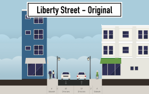
Liberty Street was not always so wide. Before 1955 the street, which now dead ends at Reading Road and the I-471 ramps, extended from Highland Avenue on the hill in Mt. Auburn to the U.S. Post Office facility in Queensgate. The width of the street was a modest 25 feet.

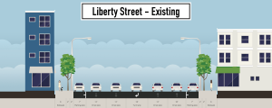
In 1955, however, the city decided to widen and connect it to Reading Road as a east-west cross town access point for the interstate highway system. Buildings on the south side of the street were demolished and the street was widened from a two lane road to one with five lanes.

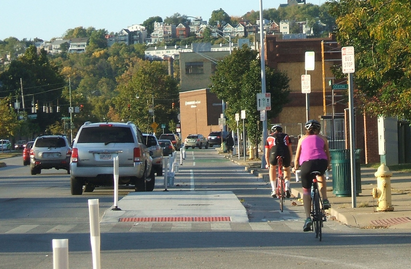
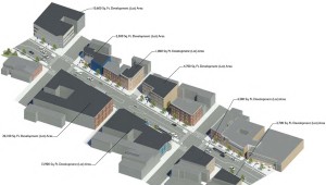
The street is currently 70 feet wide and is both dangerous and difficult to cross for people walking. Development has not taken place on the south side of the street since most of remaining lots are too small and oddly shaped for development.

Beyond its physical barriers, Liberty Street also serves as a psychological barrier between the nascent Brewery District and vibrant Gateway Quarter.

In 2012, the City’s Department of Transportation & Engineering began studying ways to calm traffic on the street in order to make it safer. After spending two years evaluating traffic conditions, City Hall is beginning to engage the public for comment on the proposal. The first will be tomorrow night at the Woodward Theater.

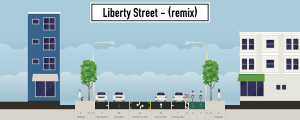
The session will build upon the idea proposed in the OTR Brewery District Master Plan, which called for the removal of a lane of traffic to add protected bicycle lanes in both directions. The UrbanCincy team recently discussed the proposal and found that while this is a good starting point, there is a larger opportunity for the street to spur more redevelopment along the corridor.

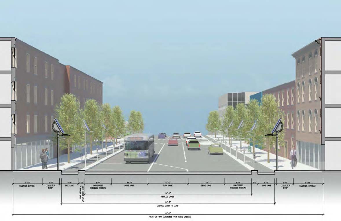
Our proposal eliminates one lane of traffic in each direction, but preserves the middle turn lane. A two-way contraflow protected bicycle lane would then be installed on the south side of the street. This leaves approximately 15 feet of unused street right-of-way.

This unused right-of-way could be returned to property owners on the south side of the street, thus narrowing the overall street by 15 feet. It would also increase the size of the southern properties which would increase their development potential and improve safety for pedestrians crossing the street. This would serve as particularly beneficial for small parcels such as those at the corner of Vine and Liberty or between Main and Sycamore.

This idea builds on the ideas put forward by Jeff Speck, who recently released a video on traffic calming and embraces modern street design standards that are found in the National Association of City Transportation Officials Street Design Manual.

The Liberty Street Safety Improvement Open House will take place at the Woodward Theater located at 1404 Main Street in Over-the-Rhine. The session starts at 6pm and will last until 8pm. It is served by the #16, 17, 19 and 24 Metro bus routes, and is less than a block away from a Cincy Red Bike station.

Categories
News Transportation

VIDEO: The Easy and Inexpensive Way For Cincinnati To Make Its Streets Safer

Anyone who rides a bicycle to work, either their own or on a Cincy Red Bike, knows all to well the commute mostly involves sharing the road with automobiles. With the current city administration focusing more on creating recreational trails for bicycle hobbyists, cyclists who bike as a form of transportation can only daydream about better on-street bicycle infrastructure.

That daydream could come closer to reality with the release of a new animation from planner and author Jeff Speck.

An accomplished author of books such as Walkable City and Suburban Nation, Speck describes four simple street reconfiguration options that would better accommodate all modes of transportation without adding to the roadway’s width. In order to accomplish that, the techniques include narrowing lanes, adding striped or buffered bike lanes.

Planners and engineers have found that such changes have a minimal impact on the flow of vehicular traffic, by adding only seconds onto commute times.

The street in the video is 38 to 40 feet in width, which is just about the average width of many streets throughout Cincinnati. In fact, UrbanCincy proposed a similar reconfiguration of Elm Street through the Central Business District in 2013. Such transformations have been noted to positively impact safety.

“Such a change on Prospect Park West in Brooklyn reduced speeding by 77% and reduced injury crashes by 63%, while having no impact on car volume or travel times,” Speck noted in the video.

When Randy Simes first wrote about the Elm Street reconfiguration, he explained that it would also serve as a critical connection point between the protected bike lane on Central Parkway and the Ohio River Trail. While Elm Street is a particularly obvious choice, other streets throughout the city could and should get some of the same treatment.

One another prominent example is Liberty Street, which Cincinnati’s Department of Transportation & Engineering has been looking at for years as a potential road diet candidate. Originally designed for much higher traffic volumes that were never realized, Liberty Street’s 70-foot width now functions more as a safety issue for people walking or biking, and as a barrier between the northern and southern portions of Over-the-Rhine.

Those plans for Liberty Street were originally envisioned by the Over-the-Rhine Brewery District, which then convinced City Hall to perform some planning work. At this time, however, the project does not appear to be moving forward.

Speck’s video makes it easy to see that for the cost of paint it would be relatively easy to install a more comprehensive bike network on streets throughout the city. Such changes would improve safety, increase the number of people riding bikes, which probably means more Red Bike usage, all while slowing down traffic just a tiny bit. Besides, even automobile drivers may appreciate not needing to directly interact with so many bicycles on the street.

Categories
Up To Speed

An easy fix for dramatically reducing the cost of building and maintaining our roadways

An easy fix for dramatically reducing the cost of building and maintaining our roadways.

Whether you know it or not, the standard width of traffic lanes on our roadways has increased over the years. The standard set forth by most state DOTs is now 12 feet for a typical lane. An increasing amount of evidence, however, shows that these widths create safety problems for drivers, pedestrians and cyclists alike. Furthermore, the additional width adds significant costs to the price of building and maintaining our roadways, and squanders valuable land. More from CityLab:

On city streets, most drivers ignore posted speed limits, and instead drive the speed at which they feel safe. That speed is set by the cues provided by the environment. Are there other cars near me? Is an intersection approaching? Can I see around that corner? Are there trees and buildings near the road? Are there people walking or biking nearby? And: How wide is my lane?

[…]

Our lives are currently being put at risk daily by fifty state DOTs and hundreds of county road commissions who mistakenly believe that high-speed street standards make our cities and towns safer. In my most considered opinion, these agencies have blood on their hands, and more than a little. There are many standards that they need to change, but the easiest and most important is probably the 12-foot lane.