Categories
Development News Transportation

Cincinnati becomes first Ohio city to install green bike lanes

Construction workers installed bright green bike lanes at three conflict points along Ludlow Avenue yesterday. The new green bike lanes are a first for Cincinnati as it continues to work towards making city streets safer for area bicyclists.

According to the National Association of City Transportation Officials (NACTO), experimentations with specially colored bike lanes first took place in the mid-1990s. Then, between 1997 and 1999, the City of Portland worked with the Federal Highway Administration (FHWA) to mark 10 conflict areas with blue coloring and accompanying signage. Since that time, the FHWA has determined that green is a more appropriate color for bike lanes on public streets, so as not to be confused with accessibility parking.


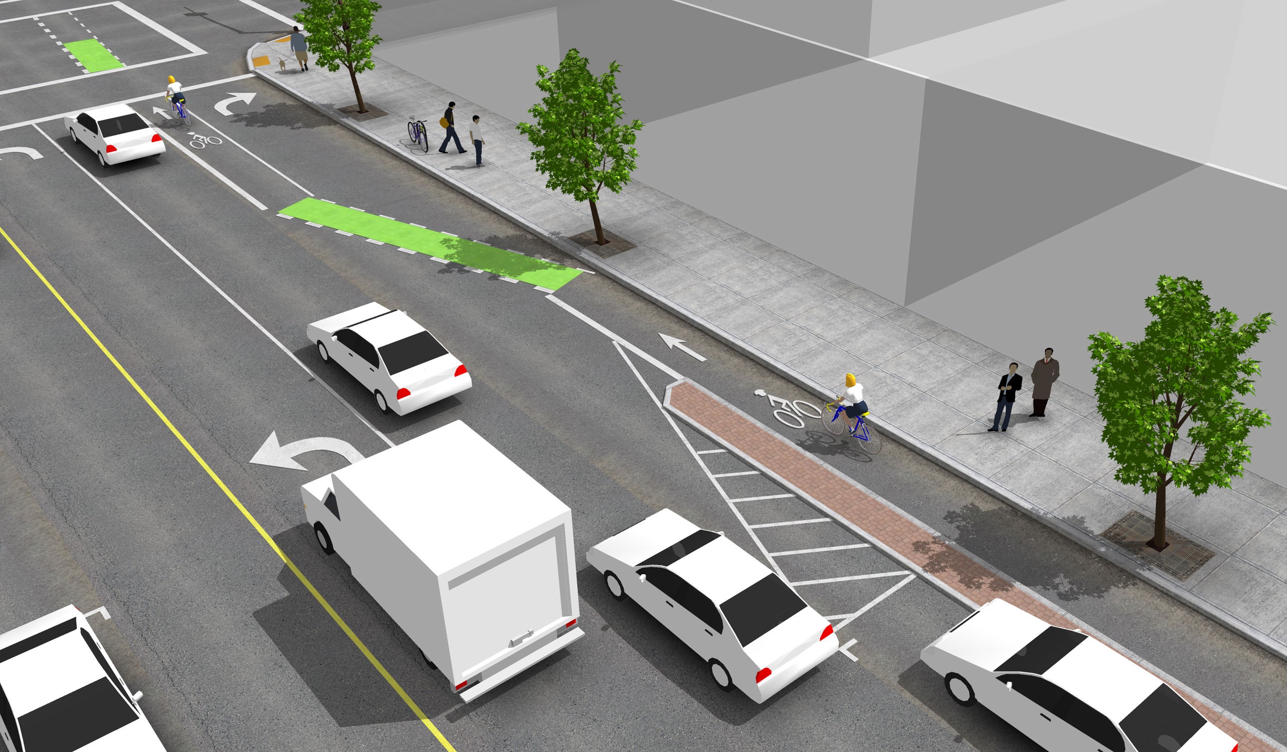
The City of Cincinnati used NACTO’s standard design for a truncated bike lane through an intersection as the basis for its green bike lanes on Ludlow Avenue. The installation makes Cincinnati the first Ohio city with green bike lanes.

Green bike lanes have begun to appear in cities throughout North America in recent years to not only mark areas of conflict, but also delineate entire bike corridors. In the Midwest, Chicago has led the charge using green bike lanes for entire cycle track corridors, bike boxes at traffic signals, and at special conflict points.

According to city officials, Cincinnati’s first application of green bike lanes will mark Ludlow Avenue where it intersects with Old Ludlow Avenue, Central Parkway and a driveway entrance to Cincinnati State (map). City planners also say that there will be additional green bike lanes to come.

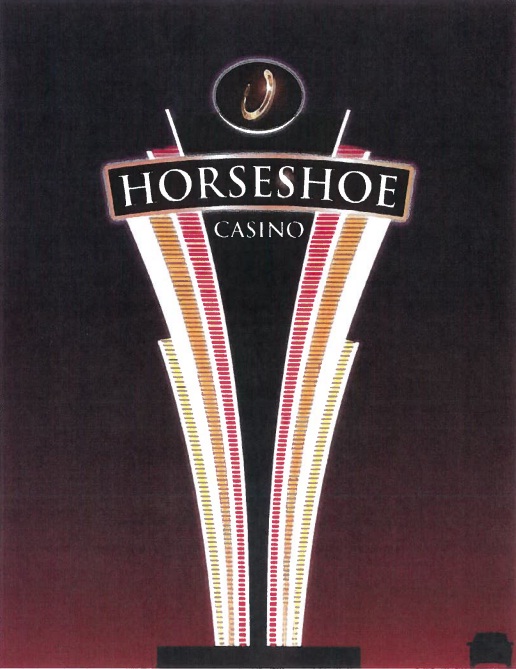
“We are considering using green markings where the Gilbert Avenue bike lane will intersect with the right-turn lane into the casino,” explained Department of Transportation & Engineering (DOTE) planner, Melissa McVay.

McVay went on to say that City is using NACTO’s design guidelines and specifications for these projects, and that going forward, green bike lanes will be considered at all high conflict areas where motorists must cross a bicycle path.

The idea behind the green markings is to improve the visibility of bicyclists, and in the process, improving safety.

“In this [Ludlow Avenue] case the green lanes help negotiate cars desiring a right hand turn through a bike lane that continues straight ahead,” said Frank Henson, President, Queen City Bike. “By giving the bicycle lanes a different color, motorists realize that, in making their turn, they are crossing into another travel lane reserved for cyclists, and that they must yield to bicycle traffic in order to complete the turn.”

The City of Cincinnati Bicycle Transportation Program has installed 35.8 miles of bicycle facilities to-date, with an additional 289.9 miles planned in a citywide bicycle network.

And when asked about what could be done to continue to improve safety for Cincinnati-area bicyclists, Henson concluded that, “The best thing the City of Cincinnati can do to improve safety for street cycling is to continue to carry out the Cincinnati Bike Plan, improving the network of bike routes, lanes, trails, and paths in the area. Better education and enforcement of traffic law for both cyclists and motor vehicle operators is also necessary.”

We sat down with Melissa McVay on Episode 8 of The UrbanCincy Podcast to discuss Cincinnati’s bike culture – where we stand, how we got here, and what needs to take place next. You can stream that podcast online for free, or subscribe to The UrbanCincy Podcast on iTunes so that you don’t miss an episode.

Categories
Development News

$450,000 donation from Duke Energy to advance construction at Smale Riverfront Park

Thanks to a $450,000 donation from Duke Energy, the Cincinnati Park Board will be able to move forward more quickly with the development of what was previously called the Main Street Garden at the Smale Riverfront Park.

The area is located immediately south of Great American Ball Park, and is now called the Duke Energy Garden. The narrow piece of park space is expected to be completed by spring 2013, and will connect the Smale Riverfront Park with additional riverfront parkland to the east (Sawyer Point, Bicentennial Commons, Theordore M. Berry International Friendship Park).


The Duke Energy Garden will include 12 “family-sized” porch swings, walking paths, and will help connect the Smale Riverfront Park with additional riverfront parks to the east. Rendering provided.

According to Cincinnati Park Board officials, this connection will be further established with the completion of the Ohio River Trail to Paddlewheel Park in fall 2013.

“The Cincinnati riverfront is more than just an entryway into our community,” Julie Janson, President of Duke Energy Ohio/Kentucky, stated at a Monday morning press conference. “It serves as the front porch to Ohio. That’s why Duke Energy, through our foundation, is happy to be able to support the creation of the Duke Energy Garden in the new Smale Riverfront Park.”

According to park officials, the Duke Energy Garden will include 87 trees, thousands of smaller plantings, walking paths, a 150-foot granite seat wall, and 12 “family-sized” porch swings.

The porch swings will be suspended from “undulating” pergolas that will also offer park-users a bit of shade and protection from the elements while enjoying the swings, which have long been anticipated at the park due to their popularity elsewhere throughout the country.


Three additional phases of work are planned to follow the completion of the Duke Energy Garden at Smale Riverfront Park. Image provided.

“Duke Energy’s commitment to the vitality of this region has been demonstrated again and again by the company’s substantial investments in economic development, education, environmental and energy efficiency efforts throughout the region,” said Willie F. Carden, Jr., Director of Cincinnati Parks. “The establishment of the Duke Energy Garden in Smale Riverfront Park is another such gift that will provide a stunning new public greenspace in Greater Cincinnati’s grand new front yard.”

The majority of phase one work at the Smale Riverfront Park was completed in May 2012, but several features of phase one have yet to be funded or built, in addition to future phases of park construction to the west. Some of those features include a transient boat dock, playgrounds, additional gardens and tree groves, a carousel, and more promenades and fountains connecting the central riverfront park with the Ohio River.

Three additional phases of construction work will take place following the completion of the Duke Energy Garden, and it is expected that once fully built out that Smale Riverfront Park will attract approximately 1.1 million visitors annually.

Categories
Development Opinion

Horseshoe Casino Cincinnati requesting 80-foot sign

On Wednesday, the City of Cincinnati’s Zoning Hearings Examiner will hear a request from the owners of the new Horseshoe Casino asking for the city to grant several variances to the city’s sign ordinance for signage at the casino site. Casino representatives are asking for more signage and larger signs than the current ordinance allows.

A variety of signs are included in the package including three signs that will display a real-time count of available parking spaces in the casino garage, and a monument sign that will located along Gilbert Avenue and rise 80 feet in height.

The sign, which is 943 square feet in size, exceeds the maximum allowed signage by 678 square feet in total area and 64 feet in height. According to the plans, the sign will be illuminated and visible along I-71 and up Gilbert Avenue into Walnut Hills, as well as parts of Mount Auburn and Mount Adams. For reference, the sign will be taller than the six-story building currently housing casino construction offices at Broadway Street and Eggleston Avenue, and will dominate the skyline view looking south from I-71 like a peculiar star above the Greyhound bus terminal.

In requesting for the sign variance, casino officials argued that they need the site to be visible to drivers along I-71. Once erected, the sign will tower above the casino complex and adjacent highway as a beacon of hope and good fortune to gamblers, and serve as a landmark to those traveling through downtown Cincinnati.

Residents living along Reading Road and in Mount Adams will also be able to bask in the comforting warm neon glow emanating from the sign at night. In fact, some may never need a night light again!

Some neighborhood leaders have raised concerns that the meeting is being held without enough notice for neighborhood councils; however, it seems to be in the city’s interest to get this sign up as soon as possible so suburbanites have plenty of lead time to know exactly where the casino is and how many parking spaces are free in its breathtakingly massive parking garage.

Already, out-of-towners are looking to flock to the casino but are unsure of its exact location.

“I was approached by a woman at the airport the other day and she asked me where the casino was being built,” disclosed UrbanCincy Chief Technologist Travis Estell. Thankfully, the woman will now know where the casino is with this gargantuan sign!

Springboro resident Chris Cousins also shared his enthusiasm for the proposed sign saying, “I’m really looking forward to dining at the casino’s buffet and this sign will point me in the right direction.”

The meeting will take place Wednesday, October 24 at 9am in the Permit Center located at 3300 Central Parkway (map). This facility is served by Metro’s #20 bus route.

Categories
Arts & Entertainment Development Transportation

New time-lapse video captures movement of people and machines in Cincinnati

Friend of UrbanCincy and regular URBANexchange attendee, Andrew Stahlke, has produced a new time-lapse video of Cincinnati.

The video showcases construction work at the $400 million Horseshoe Casino, Little Miami Scenic Trail, Eden Park Overlook, boats on the Ohio River, circus training at Burnett Woods, freight activity at the Queensgate Railyards, construction of the new $66.5 million Waldvogel Viaduct, fans at Great American Ball Park, and many other scenes from around Cincinnati.

Stahlke is currently enrolled in the Masters of Community Planning program at the University of Cincinnati, and originally studied civil engineering at Case Western University.

The video, entitled Paths and Nodes: Cincinnati, attempts to capture the life of the city as people and machines move about, and was shot in early fall 2012. It is a nearly three minutes in length, and features music from Little People.

Categories
Business Development Transportation

Cincinnati City Leaders to Move Forward with Ohio’s First Bike Sharing System

A new study, prepared by Alta Planning + Design, has determined how and where a bicycle sharing system could be implemented in Cincinnati in a way that will compliment its expanding Bicycle Transportation Program.

The recently released report was called for by city leaders in May 2012, and identifies a 35-station, 350-bike system that would be built over two phases in Downtown, Over-the-Rhine, Pendleton, Clifton Heights, Corryville, Clifton, Avondale and the West End.

“We went into this study wanting the public to be a big part of the process. They contributed more than 300 suggestions for stations and cast nearly 2,000 votes,” said Michael Moore, Director of the Department of Transportation & Engineering (DOTE). “Thanks to all their input, this study helps ensure bike share is relevant and useful to the residents and commuters in the downtown neighborhoods.”


Several neighborhoods throughout the city were determined as potential areas to be included in a future Cincinnati bike share system. Map provided by Alta Planning + Design.

City officials also say that locations throughout northern Kentucky’s river cities were also popular, and would make for a logical expansion in the future should system arrangements be achieved.

According to the report, the 35 station locations were identified through public input and through a variety of suitability factors that include population density, percentage of residents between the ages of 20 and 40, employment density, mixture of uses and entertainment destinations, connectivity with existing and planned transit networks, and the terrain in the immediate area.

“In general, there are enough positive indicators to suggest that bike sharing is feasible in Cincinnati,” Alta Planning + Design wrote in the 49-page report. “There are no fatal flaws, although a smaller dependency on visitors and ordinances restricting advertising would need to be overcome to make the system financially viable.”

The financial viability of the project is particularly important in Cincinnati’s case as city officials have determined that a privately owned and operated system would be the best business model for Cincinnati.

Alta Planning + Design estimates that the potential 35-station system, spread throughout Downtown and Uptown, would cost approximately $2 million to construct and nearly $200,000 to operate annually. While user fees are expected to sustain a portion of the annual operating costs, system operators will most likely need a variance to city law to allow for advertising on the stations, as is commonplace for bike sharing systems throughout the world.

     
More than 2,000 responses helped determine public support for potential station locations [LEFT]. The initial system would be built out over two phases in Downtown and Uptown [RIGHT]. Maps provided by Alta Planning + Design.

“As of now we do not intend to invest any public funds in the system, other than in-kind assistance with marketing and station siting,” explained DOTE Senior City Planner Melissa McVay, who recently sat down to discuss Cincinnati’s bike culture on Episode #8 of The UrbanCincy Podcast.

Annual membership fees and hourly rates would be determined by the eventual company selected to operate the system, and would be contingent upon how much money could be raised through advertising and local sponsorships.

In addition to drilling into local details and demographics pertinent to a potential Cincinnati bike sharing system, the feasibility study also compared Cincinnati to other cities throughout North America that have operational bike sharing systems.

Through that analysis it was found that Cincinnati’s system would be smaller than those in Miami, Boston, Washington D.C., Montreal and Toronto, but that it would be larger than systems in San Antonio, Des Moines and Chattanooga. Cincinnati’s system is also anticipated to have a more favorable trip comparison, for the first year of operation, than both Minneapolis and Denver.

The report also estimates that Cincinnati’s system would attract 105,000 trips in its first year of operations, with that growing to 305,000 in year five once both Downtown and Uptown regions are operating, with approximately 25 percent of trips replacing a vehicle trip.

“We want Cincinnatians to be able to incorporate cycling into their daily routine, and a bike share program will help with that,” Moore explained. “Bike share helps introduce citizens to active transportation, it reduces the number of short auto trips in the urban core, and it promotes sustainable transportation options.”

The City of Cincinnati is expected to issue a request for proposals, within the next month, that will call for bids from an operator of the planned system. If all goes according to plan the Midwest’s sixth, and Ohio’s first, bike share system could become functional as early as the operator’s ability to acquire funding.