Categories
Up To Speed

More than $64.3B to be invested in North American rail transit in 2013

More than $64.3B to be invested in North American rail transit in 2013.

As the migration of people from the suburbs back to cities continues, so does the investment in urban forms of transport. A modern streetcar route is currently under construction in Cincinnati, and bus rapid transit, light rail and commuter rail is all being studied for the area. Nationally, more than $64.3 billion is being invested to expand rail transit. More from The Transport Politic (including map):

What is evident is that certain cities are investing far more than others. Among American cities, Denver, Honolulu, Houston, Los Angeles, New York, San Francisco, Seattle, and Washington stand out as regions that are currently investing particularly dramatically. Toronto has the biggest investments under way in Canada. These metropolitan areas have invested billions of local dollars in interconnected transit projects that will aid in the creation of more livable, multi-modal environments. Dynamic, growing cities require continuous investment in their transit systems.

Categories
Business News Transportation

Nate Wessel aiming to change the way Cincinnati does maps

Maps are used in our everyday lives to help us navigate our cities, perform research, and visualize spatial data, but Nate Wessel has attempted to change the way Cincinnatians view such information.

In June 2011, Wessel started a modest Kickstarter campaign that would raise money to print a transit frequency map he had developed. Instead of using the typical approach to developing a bus system map, Wessel adjusted colors and line weights according to the frequency of service along each bus route.
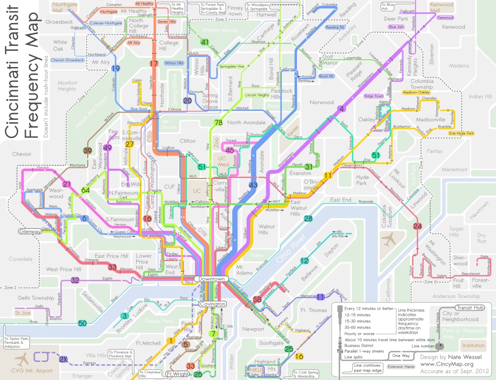

Cincinnati Frequent Transit Map (Day Time). Image provided by Nate Wessel.

While he simplified the system map, he also added critical wayfinding information such as neighborhood business districts, parks, neighborhoods and natural landscape features.

“The maps used currently will put the 38X on the same visual level as the 17, but one runs three times a day in each direction, and the other runs almost 100 times a day in each direction,” Wessel explained. “In no way does the map indicate any more value for one over the other, but my map gives people an approximate idea of how long you’ll need to wait, in addition to how frequent the buses come and where they go.”

Wessel grew up in Northeast Ohio and said that his first experience with transit was biking a mile to an unmarked bus stop in Canton. Since then he has studied urban planning at the University of Cincinnati (UC) and worked with the U.S. Department of Transportation, Bureau of Transportation Statistics.

It was during his time at UC, when he realized something needed to change with the way transit information is visually presented.

“A friend of mine from China was basically saying that he felt trapped in his apartment, and didn’t know anything beyond campus and thought you could take transit, but didn’t know where it went,” recalled Wessel. “He lived in a transit-rich area, but many people like him didn’t know the correct routes to take to the right places, even easily accessible places like downtown.”
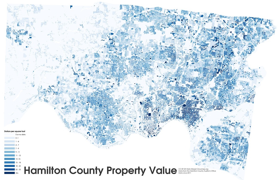

Hamilton County property values by square foot. Image provided by Nate Wessel.

The initial Kickstarter campaign raised far more money that Wessel was anticipated, and he was able to print and distribute 30,000 copies of his Cincinnati Transit Frequency Map. The map is now also featured on Southwest Ohio Regional Transit Authority’s (SORTA) website, but beyond that has not made significant inroads with regional transportation agencies.

Six months after Wessel distributed his new map, SORTA released a new regional transit map, for which they paid $20,000, that lacked the intuitive display and added information presented on the Cincinnati Transit Frequency Map.

While both SORTA and the Transit Authority of Northern Kentucky (TANK) were originally cooperative, and even contributed financially to the Kickstarter campaign, the follow-up, Wessel says, has been a bit disappointing.

Since the original release and distribution of the frequency map, Wessel has continued to improve upon it while also developing a separate night-time map, and one that focuses on center city transit service. To support those efforts, he launched a second Kickstarter campaign which funded the production of 20,000 additional maps in September 2012.

Wessel, however, has not limited himself solely to transit maps. He has released a number of maps this year that have highlighted property value data in Hamilton County, provided an exhaustive analysis of SORTA’s new transit plan, explained the theory of bus bunching, and is in the midst of an eight-part series critiquing the Cincinnati Streetcar project.

In the future he hopes to do a comprehensive map for bicycling to replace the existing one produced by the OKI Regional Council of Governments (OKI).

“In some way it’s a common interest in Cincinnati that I share with a lot of people that see the city not doing things as awesome as compared to other places, so I kind of want to do that with information about transit and cartography,” Wessel explained. “I also want people to make informed decisions about transit and planning in general, and I think that putting as much information out there in an attractive and useful manner helps.”

Nate Wessel was the winner of UrbanCincy’s first featured profile contest at the September 2012 URBANexchange. If you have a great idea we should know about, please contact the us at urbancincy@gmail.com. URBANexchange events are held on the first Wednesday of every month at the Moerlein Lager House.

Categories
Development News Transportation

Two Cincinnati projects make Sierra Club’s list of best, worst transportation investments

The Sierra Club has released their annual report ranking the best and worst transportation projects in the country. Smart Choices, Less Traffic: 50 Best and Worst Transportation Project in the United States provides a brief summary of each project included in their list, and a description as to why the project received its ranking.

The purpose of the report, the Sierra Club states, is to bring light the more than $200 billion worth of transportation projects that advance each year, and identify which of those meet higher national goals of “reducing oil consumption, increasing safety, improving public health, and saving local, state or federal government – and citizens – money.”

The State of Ohio had only two projects that made it into the Sierra Club’s 2012 report, and both were from the Cincinnati region.

The first was the Eastern Corridor project which was identified as one of the nation’s worst projects, with the report stating:

The Eastern Corridor Highway in Cincinnati, Ohio was first proposed in 1999 when the price of gas was $1.14. The project is currently under study, with plans to convert a road into a 10-mile, four- to six-lane expressway. The Highway poses a significant threat to the scenic Little Miami River. The route parallels the river and plans to cross it in an ecologically threatened area, where numerous rare, threatened and endangered species live. Furthermore, the highway will slice the historic village of Newton in half, which would disrupt the community and its tax base, adding traffic and pollution. The village’s mayor has been an outspoken critic of the project. The highway project is expected to cost upwards of a billion dollars.

The second area project that made it onto the environmental organization’s list is the Cincinnati Streetcar, which they called one of America’s best transportation projects.

The Cincinnati Streetcar is a new electric streetcar project that will connect key communities in the city’s urban core while improving neighborhood accessibility, stimulating development, and creating jobs. The streetcar system will go from the River to the Zoo, University, and hospital area. There are currently more than 500 vacant buildings along the streetcar’s 4-mile route. The streetcar will help attract residents and businesses to these rehabbed buildings, putting people to work and boosting the city’s tax revenue. Streetcars will increase accessibility and active transportation in the region by creating denser, more walkable, mixed use development. The streetcars are designed to accommodate both wheelchairs and bicycles and will serve as a complement to the city’s existing bus transit. Construction began in February 2012 and the streetcar is expected to open in 2014.

The full report identifies a wide range of projects including highways, bridges, mass transit, active transportation, aviation, aquatic, and multi-modal investments. Projects of all varieties made it onto both the good and bad lists, but the Sierra Club largely favored transit and active transportation projects over highways and bridges.

“Americans are struggling with the health, climate, and economic costs of our oil-centered transportation system,” the report states. “Our transportation investments should provide an opportunity to further reduce our dependence on oil, reverse climate disruption, and save money. Because transportation infrastructure lasts for decades, the impacts of transportation investments are felt for many years to come, with huge consequences for America’s ability to move beyond oil.”

Categories
Up To Speed

New Orleans streetcar line to get Super Bowl debut

New Orleans streetcar line to get Super Bowl debut.

New Orleans is poised to host the Super Bowl for the 10th time this February, and the first time since Hurricane Katrina devastated the city. One of the many things The Big Easy is doing to prepare for the Super Bowl is accelerate the extension of its streetcar line in order to open it in time for the visiting crowds. More from USA Today:

For many locals, the streetcar is seen as more than a show of Super Bowl pizzazz. On Canal Street, travelers will be able to hop onto other streetcars and get to the nearby French Quarter, the National World War II Museum, the Cemetery District, the oaks of Audubon Park, the mansions of St. Charles Avenue and the art museum, golf courses and lagoons of City Park.

Funding comes from a $45 million federal transportation grant. The U.S. Department of Transportation is funding similar lines in other cities to connect long-distance railway travelers to streetcars. The target is a traveler like Lawrence Freeman, a 50-year-old photographer from Seattle. He had recently arrived at the Union Passenger Terminal by train from Washington, getting in late one evening. He walked from the train station to his hotel.

Categories
Development News Politics

Blue Ash poised to create legacy park at former airport site

On August 29, 2012 the Cincinnati-Blue Ash Airport (ISZ), better known as simply the Blue Ash Airport, was closed after 60 years of service.

After its official 8am closure, yellow X’s were painted across the runway and gates were installed to block any aircraft that might land from turning onto its taxiways. Throughout the day and into the early evening dozens of pilots and other friends of the airport drove their cars and motorcycles onto the taxiway and runway for one last look.

Over the past few weeks, the original hangar building became covered with farewell messages. While most were good-natured, several blamed The City of Cincinnati’s modern streetcar project for the airport’s demise. Additionally, people I spoke with at the airport Wednesday night, with anger in their voice, informed me that their airport was being closed because “Mayor Mallory wants to build a streetcar to nowhere.”

Smearing of the Blue Ash Airport sale
Pilots and other people associated with the Blue Ash Airport have been misled by Chris Finney, his anti-tax organization COAST, and sympathetic talk radio hosts into believing that Cincinnati’s sale of the airport to Blue Ash was motivated by Cincinnati’s streetcar project. Such claims do not recognize the fact that attempts to sell the airport date to the early 2000s, years before Mark Mallory became Cincinnati’s mayor or the streetcar plan first became an item on City Council’s agenda.

Specifically, sale of the Blue Ash Airport to the Blue Ash was not possible until the citizens of Blue Ash passed a .25% earnings tax increase in 2006. This funding source provided the City of Blue Ash sufficient funds to purchase and redevelop 130 acres of Cincinnati-owned airport land into a park. Blue Ash has already used funds from this tax to build a city recreation center and an event center at its municipally-owned golf course.

In early 2007 Cincinnati City Council authorized a streetcar study and proposed using $11 million of the airport’s $38.5 million sale price for construction of the streetcar’s first phase. Cincinnati never proposed using more than this $11 million sum – approximately 29% of the airport proceeds – for streetcar construction, yet Chris Finney has convinced streetcar opponents that the entirety of the proceeds have been programmed for the streetcar.

On August 7 of this year, after a week of talk radio hype, Finney brought his political circus to a Blue Ash City Council meeting and threatened the small city with a ballot referendum similar to those he had repeatedly placed before Cincinnati’s electorate over the past 20 years.

Finney has since backed away from his promise to cause trouble in Blue Ash — a move that was hardly covered by the local media — but much damage has been done. His smear tactics succeeded in villainizing Cincinnati Mayor Mark Mallory (D), the City of Cincinnati, and the streetcar project itself. And instead of work beginning on Blue Ash’s new airport park with a sense of optimism, it is instead clouded by suspicion.


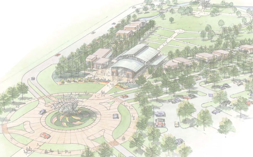
The $13.5M Blue Ash Airport Park will transform the suburban city on Cincinnati’s north side. Rendering provided.

The New Airport Park
The planned Blue Ash Airport Park will be the first large new park in suburban Cincinnati since the Federal Government transferred the 435-acre Voice of America grounds to Butler County in the early 2000s. While the Voice of America Park has seen minimal physical improvements, and some of the land even sold off for a strip mall, Blue Ash boosters have announced that the new Airport Park will be “world class”.

Given the quality of the city’s new recreation center and event space, and the continuation of the .25% earnings tax voters approved in 2006, there is every reason to expect that it will be. Unlike Voice of America Park, which is nearly entirely devoid of trees, woods are present on some of the airport property including the triangular space between the taxiways and the runway. The $13.5 million park will include a multi-purpose pavilion, two new holes for the Blue Ash golf course, a driving range, and other features.

Remaining Cincinnati-owned Property
Cincinnati’s sale of the airport land it bought in the 1940s is not over, as the city still owns approximately 100 acres, including the airport’s newly abandoned 3,500-foot runway. In 2006, after selling the land occupied by the hangers and taxiways to Blue Ash for park purposes, Cincinnati planned to reconfigure the airport along the opposite side of the runway. This did not come to pass and presumably the City of Cincinnati will sell the property in the near future.

There has been no public mention of Cincinnati’s plans for this remaining land or if Blue Ash is able to afford its estimated $20 million sale price. But even if Blue Ash is unable to buy the property and expand its new park, the small city has demonstrated that it recognizes that the quality of its built environment improves and maintains residential and commercial property values.