Categories
Business Development News Opinion Transportation

Portland Aims to Replicate Streetcar Success on East Side of Willamette River

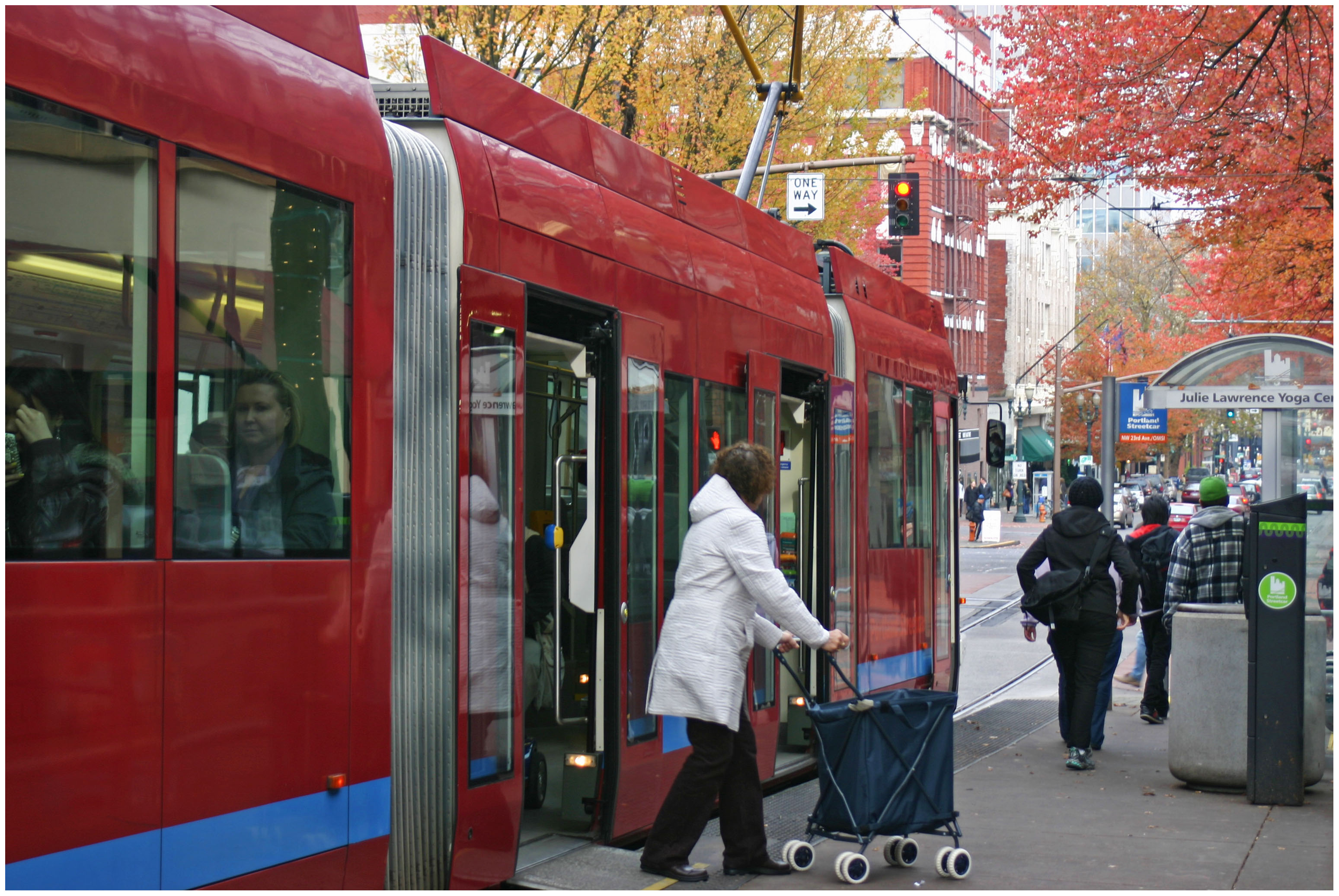
Six months ago Portland celebrated the opening of a 3.3-mile extension of their modern streetcar system across the Willamette River.

The $148.3 million Portland Streetcar project represents a significant expansion of the existing six-mile system, and city leaders hope it will find similar success in the Lloyd District, Buckman and Hosford-Abernethy neighborhoods as it has in the Pearl District and Northwest District.

At the time when Portland built its first streetcar leg, the Pearl District was a rundown industrial district in search of new life, and the Northwest District was looking to build on its existing stability.

Pearl District Buckman Neighborhood
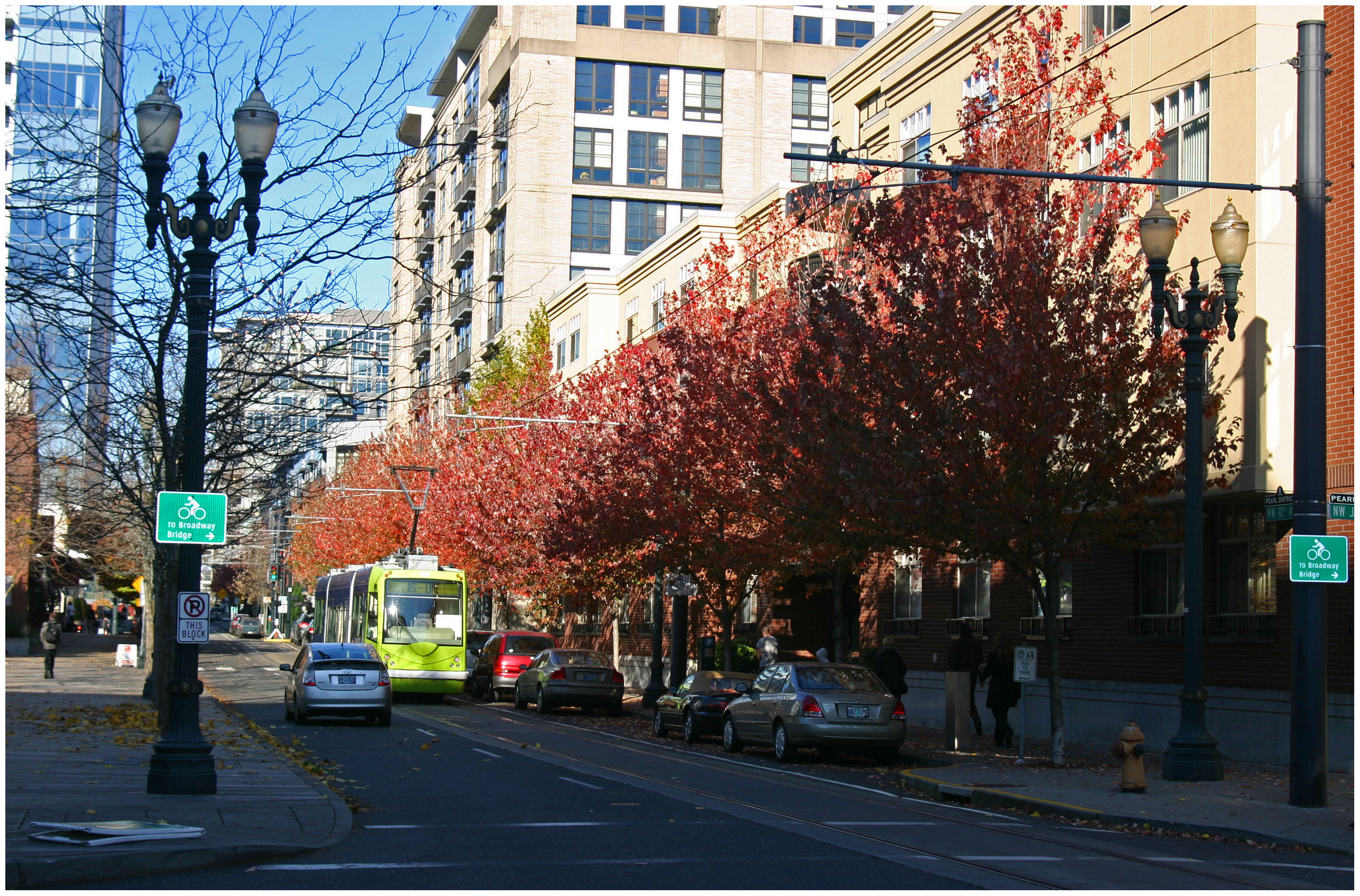
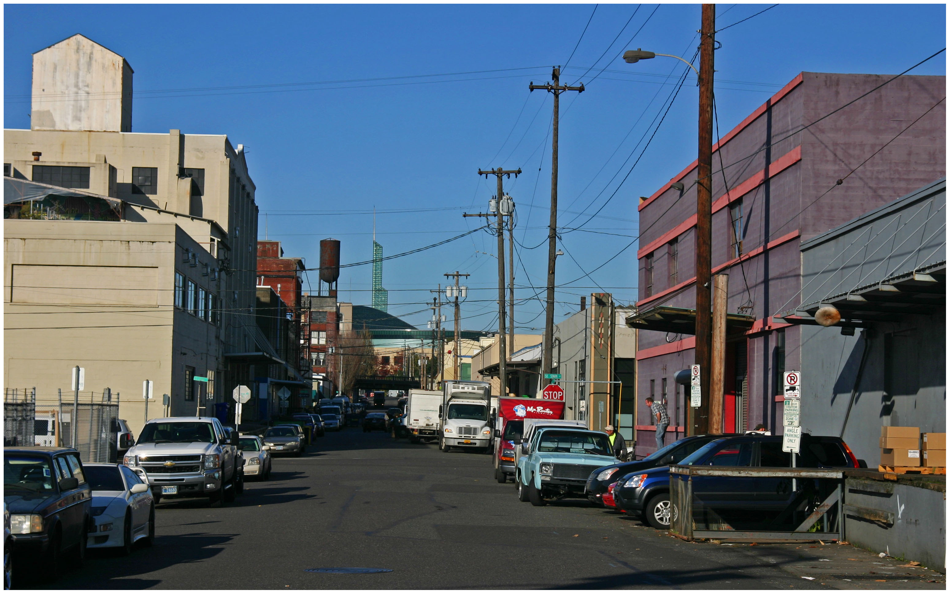
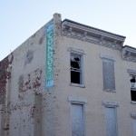
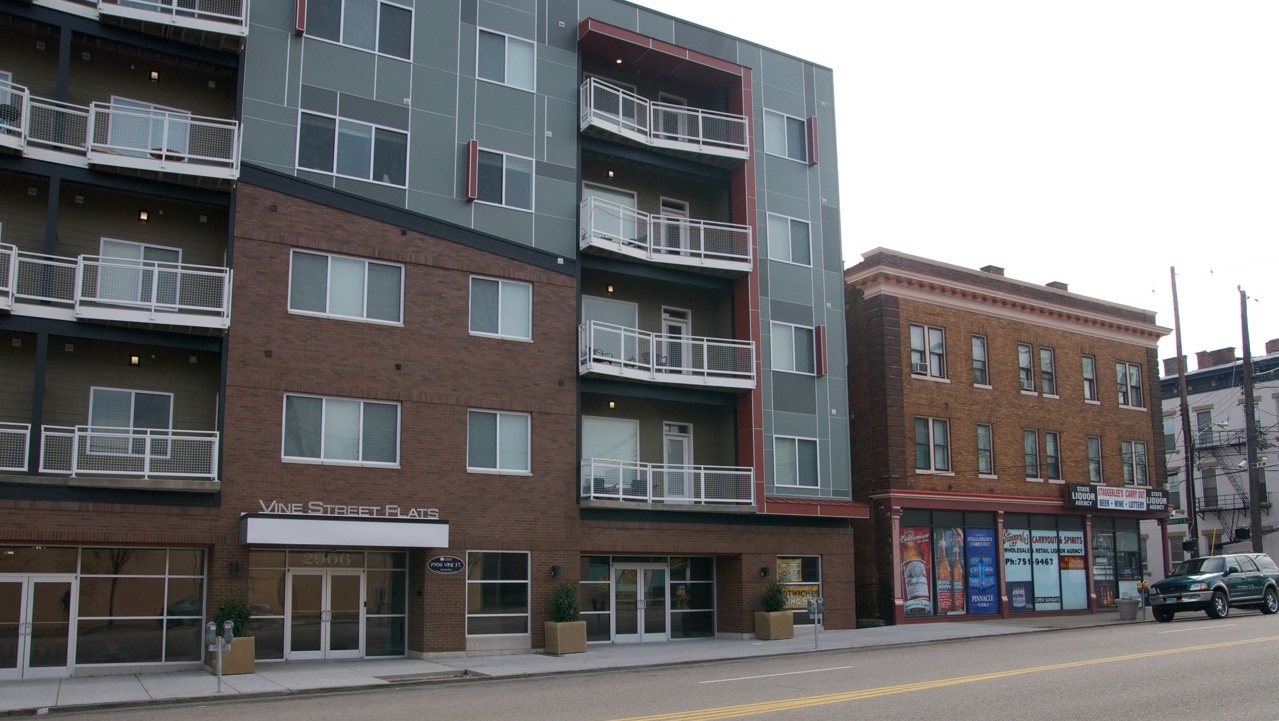
Portland’s Pearl District [LEFT] has seen a massive transformation over the past decade, and many hope the streetcar’s recent extension will do the same for the city’s Buckman neighborhood [RIGHT]. Photographs by Randy Simes for UrbanCincy.

The story is not all that different on the east side of the river where the Buckman and Hosford-Abernethy neighborhoods are looking for the streetcar to breathe new life into its underutilized land and lingering industrial users, and the Lloyd District is trying to build on its successes and possibly reinvent itself with a lesser focus on the automobile.

While the streetcar extension is operating daily, the investments are not quite finished. Transportation officials are waiting on an additional six streetcar vehicles to roll off the production line so that service frequencies can be improved for the system’s four million annual riders.

TriMet officials are also overseeing progress on the construction of the new Portland-Milwaukie Bridge which will provide a river crossing for bicycles, pedestrians, streetcars, and light rail from Hosf0rd-Abernethy to the South Waterfront District as part of a the 7.3-mile Portland-Milwaukie Light Rail Project.

The $134 million bridge project is expected to open in September 2015 and buoy both new and existing ridership on the city’s light rail and streetcar systems.

Portland-Milwaukie Light Rail Bridge South Waterfront District
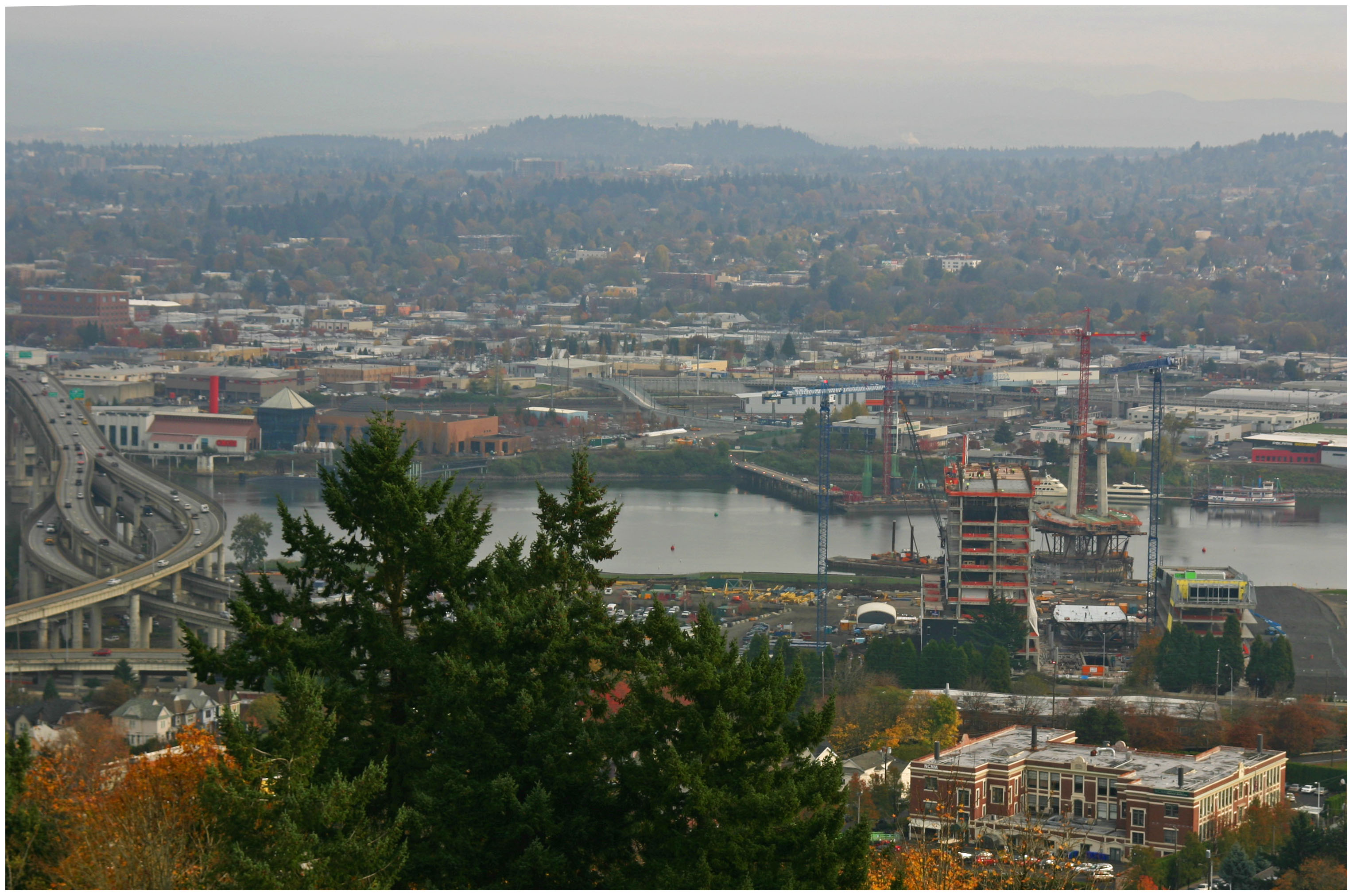
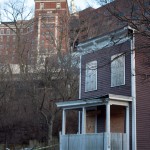
Construction progresses on the Portland-Milwaukie Light Rail Bridge in November 2012 [LEFT], which will connect the Hosford-Abernethy neighborhood with the South Waterfront District [RIGHT]. Photographs by Randy Simes for UrbanCincy.

The verdict is still out on whether or not the new east side streetcar extension will have as big of an impact as it did on the west side of the river next to downtown, but the possibilities are there.

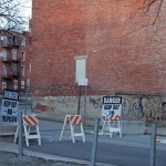
The streetcar’s alignment through Buckman and Hosford-Abernethy heads south along Martin Luther King Boulevard and north a block over on Grand Avenue. To the west of MLK Boulevard is the river with a large collection of warehouses in between. To the east of Grand Avenue is an in-tact neighborhood that has become increasingly popular with young creative types over the past several years.

In between the two streets one will find a collection of aging car dealerships and associated service businesses that date back to the mid-twentieth century.

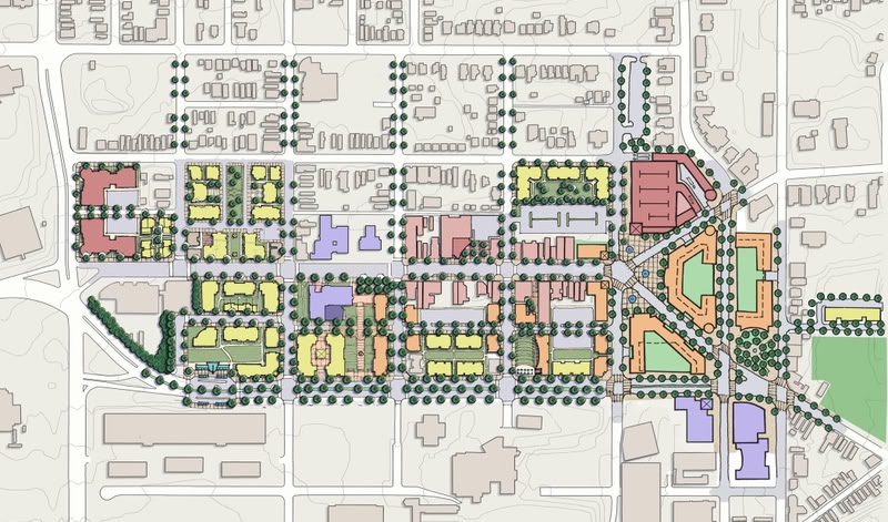
These large parcels, combined with the large warehouse properties immediately to the west, offer a unique opportunity for large scale redevelopment. Such massive real estate investment might not be plausible without another real estate bubble.

The prospects are there, however, and if Portland can pull off even a fraction of the investment in Buckman as they saw in the Pearl District, then the city will add billions of dollars to its real estate value and create a secondary downtown in the city center for the 2.2 million person region.

Categories
Business Development News

PHOTOS: Historic Glencoe-Auburn Place Row Houses are Being Demolished

After more than a decade of failed redevelopment plans demolition of the 129-year-old Glencoe-Auburn Place Row Houses began on March 19.

Known colloquially as “The Hole” for its dramatic hillside setting in historic Mt. Auburn, the multi-building complex abuts Christ Hospital and has long been eyed in its expansion plans. The complex was listed on the National Register of Historic Places in December 2003, at the request of architect Tom Hefley and developer Pauline Van der Haer.

Christ Hospital Expansion
This aerial photograph from September 2012 shows both the Christ Hospital Expansion [CENTER-LEFT] and the historic “Glencoe Hole” [MIDDLE RIGHT]. Image provided.

Van der Hear, through her development company named Dorian Development, planned to renovate the complex into 68 market-rate condominiums during the early 2000s housing bubble. The “Condos Available” sign, still visible after today’s demolition work, has been in place since at least 2004, when the project was featured prominently in Cincinnati Magazine.

The large-scale modification of the old buildings (the original apartment units all have three very small floors connected by unusually narrow staircases) and the need for a multi-deck parking garage made the creation of a viable project impossible without large subsidies from the City of Cincinnati. Since the early 2000s Van der Hear has been involved in several high profile attempts to win awards from the City.

COAST attacked the project in 2008 after it received a $300,000 grant from the city, but in 2009 Christ Hospital took advantage of the collapse of the condo market and moved to acquire the complex from Dorian Development. Van der Haer sued Christ Hospital in 2011, claiming “tortious, deliberate, intentional and malicious interference” in her development plans, but the Ohio Supreme Court and an appellate court ruled in the hospital’s favor, citing the lack of a written contract between the City and Dorian Development.

The arrival of bulldozers adds to a growing list of historic properties uptown that have faced similar fates in recent years as a surge of private investment has moved in to construct hundreds of new residences and hundreds of thousands of square feet of new commercial space.

The following 12 images were all taken by Jake Mecklenborg at the site on Tuesday, March 19 – just five days after a demolition permit had been granted.

Categories
Business Development News

Private Investment Continues to Flow Uptown to Corryville and Short Vine

The Short Vine Business District is starting to show signs of a revitalization that has been a long time coming.

Uptown generally is seeing a wave of real estate investment and concurrent transportation investment. City and State officials are working to put the final pieces of  funding together for a new $70 million MLK Interchange that may also include upgrades to the Taft/McMillan interchange. Current estimates foresee project completion sometime around 2016.

Further helping accellerate the reinvestment uptown is the growing number of high-wage jobs in the area. Corryville’s neighborhood business district, for example, is surrounded by the University of Cincinnati, six major hospitals, and is within one mile of two interstates.

Short Vine Master Plan_2007 Update
Short Vine’s master plan was updated in 2007 through a partnership between the City of Cincinnati and Uptown Consortium. While much of the plan has not been adhered to, significant change is taking place along Short Vine and its surrounding streets.

The last few years saw the introduction of a handful new businesses, such as Island Fridays, Dive Bar, and Zipscene, a startup company. Recent openings include Mio’s Pizza, a third Beelistic Tattoo location, Caribe Carryout and new eateries Hang Over Easy, Smoke, and Taste of Belgium will open in the near future.

The rehabilitation of these structures capitalized on the historic charms found therein; Smoke and Hang Over Easy used reclaimed doors, chalkboards and windows from the recently demolished Schiel School. The edgy interior designs employed by all of these businesses show a remarkable congruence to the unique character that has always been represented on Short Vine.

Bogart’s, the 36-year old concert venue and an anchor establishment in the business district, just underwent renovations upwards of $100,000 as it seeks to attract more national performers.

The Old Schiel School, which closed in 2010, was torn down and is being redeveloped into a $20 million structure that will include 106 apartments and street-level commercial space. The previous owner of the site, Fifth Third Bank, has already signed on as a tenant for one of the street-level retail spaces. As noted, Taste of Belgium will also grow their footprint and open their first uptown location at the site.

The project with the most potential to be truly transformative, however, might be the redevelopment of University Plaza.

Vine Street Flats
One of Short Vine’s newest buildings, Vine Street Flats, sits immediately next to one of the business district’s long-time structures. Photograph by Luca Acito for UrbanCincy.

Although there were original hopes of reconnecting Vine Street with Short Vine, the plaza site will not change but the current structure will be demolished. Kroger and Walgreens are the only current tenants expected to remain.

The Uptown Consortium thus far has served as an effective catalyst for business attraction, retention and investment in the area.

The community development corporation was awarded $40 million in tax credits in 2012, with 90% of the funds going towards the redevelopment of University Plaza and the former Schiel School site.

Additionally, last month Cincinnati City Council approved the Uptown Consortium’s application for a Community Entertainment District (CED) to cover 77 acres and 150 properties on Short Vine, thus allowing the distribution of 15 new liquor licenses within the CED.

New streetscaping will include buried utilities, wider café-style sidewalks, street narrowing, new street trees and reconfigured parallel parking are all part of the improvements approved by City Council in 2011.

“Within a few years, this area will have been transformed,” asserted John Pedro, co-owner of Dive Bar, Smoke and Hang Over Easy.

Categories
Business Development News

Work on Smale Riverfront Park Progresses Despite Lack of State, Federal Funds

The $120 million Smale Riverfront Park will celebrate its next wave of progress two months from now when the Women’s Committee Garden and Duke Energy Garden are opened to the public – more than doubling the central riverfront park’s completed acreage.

According to officials from the Cincinnati Park Board, the project is still on-time and on-budget thanks to an influx of private contributions.

Originally, park officials had planned on approximately half of the project’s cost being covered by state and federal funds. While those funds flowed early in the project’s life, they have all but dried up over the past two years.

Cincinnati Central Riverfront Plan

“We got into this pretty aware of what the challenges were, but the biggest challenges thus far have probably been the state and federal funding,” stated Smale Riverfront Park’s project manager, Dave Prather. “It’s been a pretty big adjustment when half of the funding you were counting on hasn’t come, but thanks to the private funding we’ve been able to stay pretty much on schedule.”

Prather says that the city leadership understands the realities facing both their state and federal partners, but that without the private and local support the project would most likely be behind schedule.

He is, however, optimistic that things will turn around and says that the park board is working on other ways to get state and federal dollars. One such element that could be the beneficiary of such efforts is the planned 1,000-foot transient boat dock which may be eligible for up to $3 million in grants from the Ohio Department of Natural Resources (ODNR) Division of Watercraft.

Should such funding fall into place, Prather says that the boat dock could be operational as early as May or July 2015.

“We received $3 million in the State capital fund three years ago, and that’s what we thought we would get as we worked through the phasing plan,” Prather explained. “Hopefully the state will get back in the business of being able to help with significant capital projects.”

Not all of the funding news has been grim, as Prather noted strong support from Hamilton County, private sources, and the City of Cincinnati which includes a recent $4 million allocation from the proceeds of its recently approved Parking Modernization & Lease agreement.

That $4 million will go towards accelerating the construction timeline of phase four of construction work which will now include the PNC Grow Up Great Adventure Playground and carousel. According to Prather, both of these projects will now be completed by May 2015 – in time for the 2015 Major League Baseball All-Star Game.

One of the features that will be open in two months is the new riverwalk, of sorts, that will run from the Walnut Street Overlook approximately to Sycamore Street immediately south of Great American Ball Park. One of the key features of this riverwalk, Prather notes, is that the guardrails will be 48 inches in height instead of 42 inches so that both pedestrians and bicyclists can enjoy the pathway.

“Our observation has been that you can’t tell cyclists where to go,” said Prather who noted that he is an avid cyclist himself. “So we’re going to construct the closest to the river pathway to accommodate both pedestrians and cyclists – right where they both want to be.”

While much work is left to do, both in terms of construction and securing funds to continue construction, the project team maintains excitement for the transformation they are overseeing.

“I’ve been an architect and a planner for the city for years, and a lot of the time you spend a lot of time and energy on plans that don’t get built,” Prather concluded. “This one [project] is different…we’re just on a roll and it’s awesome to have ideas that everyone embraces, you feel right about what you’re building, and you get the resources to actually build it. We’ve gotten a lot of cooperation from the city and county, and I feel like we’re all rowing in the same direction.”

Officials hope to complete the 45-acre park in its entirety by July 2017, excluding improvements to the river’s edge that will need to be coordinated with the U.S. Army Corps of Engineers.

Categories
Business News Transportation

STUDY: Suburban Residents Have Longest Commutes in Cincinnati Region

The Cincinnati region scores better in several metrics that most American cities with regards to commuting patterns.

That is according to new study released by the U.S. Census Bureau, Out-of-State & Long Commutes, which shows that Cincinnatians spend three fewer minutes commuting each way when compared to the average American. The study also finds that only 2.9% of Cincinnatians spend more than 60 minutes one-way during their commute, as compared to the 8.1% national average.

The central concentration of jobs and economic power in the Cincinnati region also impacts the distribution of these travel times, with close-in neighborhoods boasting lower commute times and far-flung neighborhoods with the highest.

Cincinnati Commutes

“It is well known that Hamilton County draws a lot of commuters to work,” said Brian McKenzie, a Census Bureau statistician who studies commuting.

The draw of Hamilton County is strong. According to the Bureau, more than 188,000 people commute to and from Hamilton County each day, placing it at the top end of the spectrum in the U.S. Within Hamilton County, however, the East Side has it better off with lower average commute times, by about five minutes, as compared to the West Side.

The study also found that a mere 3.9% of Hamilton County commuters used public transportation in 2011. The rate of public transportation use is slightly lower than the national 5% average, and also does not take into account recent ridership increases that have outpaced national gains.

“The average travel time for workers who commute by public transportation is higher than that of workers who use other modes,” McKenzie continued. “For some workers, using transit is a necessity, but others simply choose a longer travel time over sitting in traffic.”

Due to the lack of a comprehensive regional transit system, approximately 79.3% of Cincinnatians are stuck behind the wheel of a car by themselves, and another 9.2% are carpooling to work each day.

The data for the study came from the American Community Survey (ACS), which collects information on education, occupation, language, ancestry, housing costs and transportation. The ACS has been ongoing in some form since 1850, approximately 60 years after the nation’s first decennial census, and is currently in jeopardy of losing its funding.

“This information shapes our understanding of the boundaries of local and regional economies, as people and goods move across the nation’s transportation networks,” McKenzie concluded.