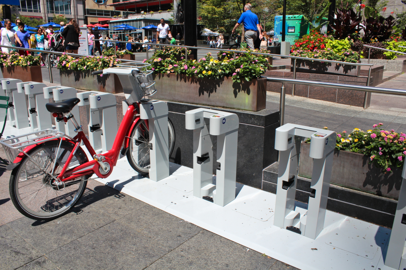
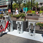
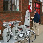
Last week’s press conference on Fountain Square revealed a number of new details regarding Cincinnati’s new bike share system. In addition to unveiling the design of the bikes, stations and membership cards, officials also finally shared the system’s name – Cincy Red Bike.
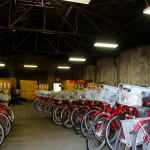
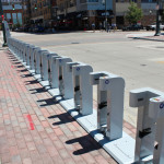
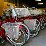
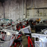
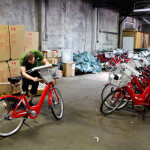
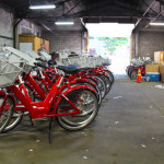
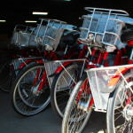
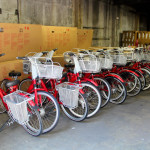
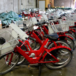
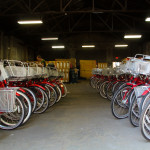
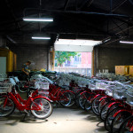
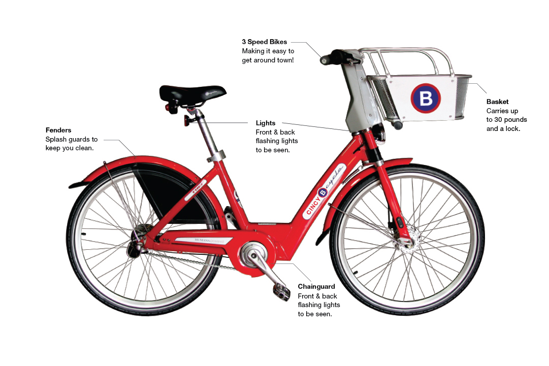
Jason Barron, executive director of Cincy Red Bike, said that dozens of volunteers quickly assembled 260 of the bikes that will populate the initial 35-station system. Barron further clarified a point discussed in our analysis from just before the conference, and stated that each station will have between 13 and 19 docks, thus giving the system an initial docking capacity of 520 bikes. This would easily exceed the ideal 50% space contingency.
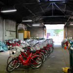
Inside the Cincy Red Bike Operations Center [Breanna Tracy]
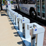
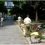
Cincy Red Bike – Freedom Center Station [Breanna Tracy]
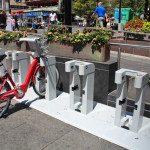
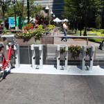
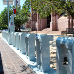
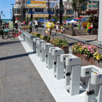
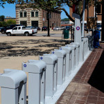
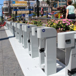
Cincy Red Bike – Fountain Square Station [Breanna Tracy]
Newly Completed Bikes [Breanna Tracy]
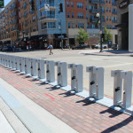
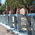
Cincy Red Bike – City Hall Station [Breanna Tracy]
Cincy Red Bike – Freedom Center Station [Breanna Tracy]
Bike Assembly [Breanna Tracy]
Cincy Red Bike – Fountain Square Station [Breanna Tracy]
Bike Assembly [Breanna Tracy]
Bike Assembly [Breanna Tracy]
Cincy Red Bike – City Hall Station [Breanna Tracy]
Bike Assembly [Breanna Tracy]
Bike Assembly [Breanna Tracy]
Newly Completed Bikes [Breanna Tracy]
Bike Assembly [Breanna Tracy]
Cincy Red Bike – Fountain Square Station [Breanna Tracy]
Cincy Red Bike – City Hall Station [Breanna Tracy]
Newly Completed Bikes [Breanna Tracy]
Inside the Cincy Red Bike Operations Center [Breanna Tracy]
Cincy Red Bike – City Hall Station [Breanna Tracy]
Cincy Red Bike – Fountain Square Station [Breanna Tracy]
Inside the Cincy Red Bike Operations Center [Breanna Tracy]
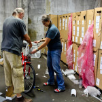
Frank Henson from Queen City Bike [Breanna Tracy]
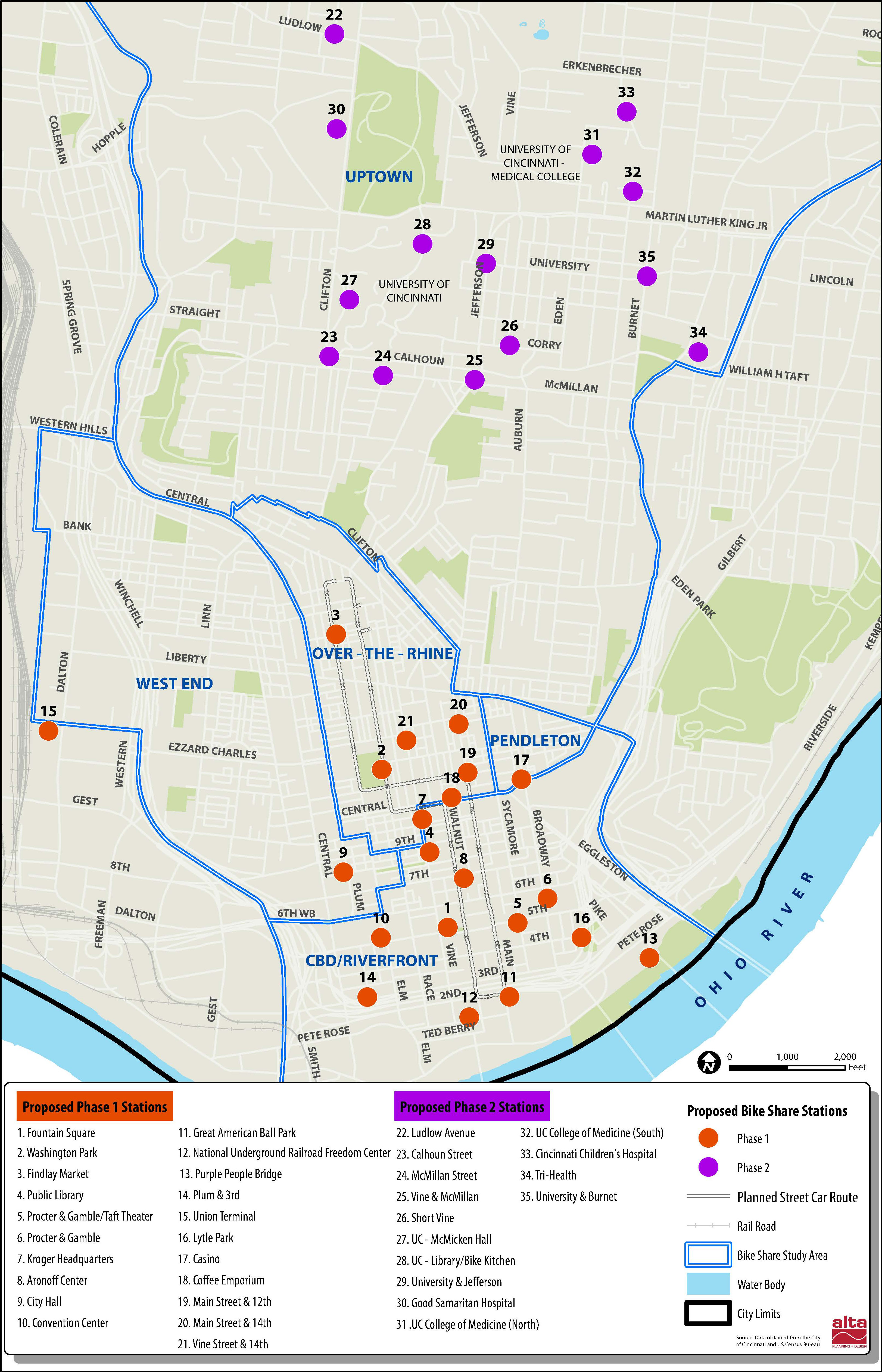
The press was also informed that the station at Union Terminal, which would have been a far off island from the rest of the initial system, has since been scratched for that very reason.
“Research indicated that having an island station like that is difficult for system balancing and that it typically does not get much use,” Barron told UrbanCincy. “An exception may be a park or someplace where people check out the bike ride it around the park and them check it back in.”
In terms of handling the balancing for such a large initial system, Cincy Red Bike will be utilizing a small van at first, but may add a trailer or a bike trailer to the balancing fleet at a later date depending on the system’s needs.
The process of getting a system like this operational so quickly comes with some challenges. While installing two to three new stations a day, officials are also still trying to work out the final membership and daily rates for users. Barron also says that the system map has changed some since initial releases, and that a new map will be released soon.
Cincinnati city officials and community leaders are expected to gather at Fountain Square Tuesday morning to unveil the first of Cincy Bike Share’s 35 stations. The ceremony will mark the official start to construction of Ohio’s second and largest bike share system.
Queen City Bike says that the process will move quickly, with two to three stations being installed daily until all 35 stations planned for Downtown and Uptown are built. At the same time, there will be a volunteer effort to assemble the system’s 300 bikes.
“We hope to assemble at least 200 bike share bikes by Friday,” said Frank Henson, President of Queen City Bike, and member of Cincy Bike Share’s Board of Trustees. “This is being done by area volunteer mechanics under the supervision of B-Cycle.”
The aggressive schedule puts the system on track to open by early September, which is not far off the initial goal of opening by August.
The progress comes after Cincinnati Mayor John Cranley (D) announced $1.1 million to more than half of the initial $2 million in upfront capital costs. At the time, Cincy Bike Share director, Jason Barron, said the commitment from the City of Cincinnati was critical in not only getting things moving, but also showing the private sector that it is all for real.
“The mayor’s commitment makes the project a true public private partnership,” Barron told UrbanCincy in April. “The City’s commitment is important to the private funders we have been speaking to, and I believe that it will unlock the last bit of funds that we need.”
Bike share systems have been growing in popularity in North America over recent years. While the most notable are Washington D.C.’s Capital Bikeshare, Chicago’s Divvy and New York City’s Citi Bike, there are now dozens of other cities operating similar systems. The large number and established time period of operations now has given planners a chance to examine empirical data to see what works best.
The more complexities you add to a mode of transportation’s functionality, the less likely someone is to choose that given mode for their trip. This is something that is true across all modes of transportation. As a result, the station density and space contingency calculations have proven to be consistent indicators for a bike share system’s success or failure.
Studies have found that a higher station density is better, and that a target should be approximately 28 stations per square mile. For a city like Cincinnati, that averages out to be a station every couple of blocks. However, the number and placement of Cincy Bike Share stations will be much lower than this target.
When examining of each of the 35 station locations, the system’s station density can be calculated in two different ways. The first would look at just the immediate area in which the stations are located. The second would look at the intended service area for those stations. Naturally, the latter is a bit more subjective.
Divvy Bike Share [Randy Simes]
Kansas City B-Cycle [Randy Simes]
Taipei Bike Share [Randy Simes]
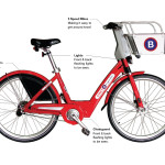
Cincy Bike Share Bike [Provided]
In the case of the first scenario, the Downtown/OTR portion of the system would have approximately 15 stations per square mile, while the Uptown portion would have 10. Overall, the system in its entirety would average out to a respectable 13 stations per square mile.
But under the more second scenario that factors for intended service area these numbers drop. In this case, Downtown/OTR would fall to 12 stations per square mile, and Uptown would plummet approximately four stations per square mile. Overall, the system total would average out to be nearly stations per square mile.
It is important to note that neither of these scenarios includes the Union Terminal station in its calculation since it is an outlier and would clearly skew the results. Furthermore, Downtown/OTR and Uptown were separated in their calculations since many planners and observers concede that the two areas will most likely operate in isolation of one another.
The point is to ensure that there are consistently stations within a short distance of one another so that if one station is full or empty, another station is close by for the potential user. If that user encounters such a situation, however, it is most likely that the potential user will avoid using bike share altogether and instead opt for a different mode.
One of the ways this can be combatted is through the use of real-time tracking technology that allows users to see exactly how many bikes or stalls are available at any station at any given time. This, of course, only aids those with access to data plans on compatible smart phones, and those who think to use it.
In order to fix the problem of full or empty stations, system operators perform ‘bike balancing’ which moves excess bikes from one station to another that is low on bikes. This balancing act proves to be one of the most costly elements of operating a bike share system. In Chicago and bigger cities they utilize small vans to move the bikes around. But in Salt Lake City, where their GREENBike system is quite small, they utilize trailers hitched to the back of other bikes.
As a result of this complex balancing act, and potential barrier to users, another key element of bike share systems is a space contingency at each station. What this means is that if a station has a capacity for 10 bikes, it should not be stocked with 10 bikes. Instead, data suggests that about a 50% space contingency is ideal.
In Cincinnati’s case, Cincy Bike Share will have enough bikes for there to be roughly nine docked at each of the system’s 35 stations. If the system were to fall in line with this 50% space contingency, which would mean that an additional four to five stalls should be available at any given time, meaning each station should have a total of 13-14 stalls. This, however, is not the case.
Cincinnati’s typical station will have 10 stalls, and thus only have a 10% space contingency. Cincy Bike Share officials have not yet commented as to how this will be mitigated, but a potential solution would be simply to not deploy all 300 bikes at once – something that seems reasonable since bikes will need to rotate in and out for repairs. In this case, a more appropriate number of bikes to be in use at any given time might be 240.
Cincinnati’s bikes are expected to be available for use 24 hours a day, and will most likely be available for use year-round. Cincy Bike Share will be responsible for setting the rate structure, which is not final yet, but annual memberships are pegged at $75 to $85 and daily passes between $6 to $8.
Uptown was originally envisioned as a second phase to the system; but now that it is being included in the initial rollout, it leaves an expansion to Northern Kentucky as the next logical choice.
More details are expected to be announced at the press event later in the week.
Not only will it be one of the most impressive bike facilities installed in the region to-date, but it will also link neighborhoods together that have large percentages of bicyclists. Furthermore, it will link other bike facilities with one another, and come close to linking even more.
Some of the existing facilities include numerous bike lanes and the Mill Creek Greenway, but the Central Parkway bike lanes will come about 12 blocks shy of connecting with the Ohio River Trail, which then links to the Little Miami Scenic Trail.
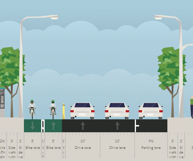
A two-way cycle track should be built in order to connect the new Central Parkway bike lanes with the Ohio River Trail and beyond.
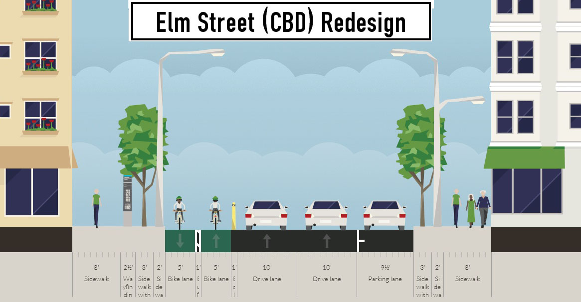
There are two streets that connect from Central Parkway to the Ohio River Trail along Mehring Way without interruption: Main Street and Elm Street. Both of the streets have one-way traffic heading northbound, but Main Street is considerably more congested with cars and buses heading to Government Square.
Elm Street, however, has some of the least congestion of any north/south street in the Central Business District and could easily connect the Central Parkway cycle track with the Ohio River Trail. A reorganization of the street would need to occur however.
Presently Elm Street, from Central Parkway to Mehring Way, lacks consistency in its design with on-street parking located haphazardly along both sides of the street. A reconfiguration of the street could consolidate all on-street parking to the east side of the street, thus eliminating only a nominal number of on-street parking spaces, and maintain 2 to 3 moving traffic lanes (the parking lane could be restricted during rush hours to allow for a third travel lane).
The Elm Street cycle track, meanwhile, would be located along the west side of the street and be buffered from moving traffic by a row of bollards. Such a redesign of Elm Street would be a bit of a road diet, but one that seems reasonable for this stretch of overbuilt roadway.
Planners with the City’s Department of Transportation & Engineering (DOTE) said that the idea of an Elm Street cycle track had not come up before, and has not been presented to any formal committees or community councils to-date. Such coordination, they say, would need to take place prior to the idea moving forward.
Projects like this are low-hanging fruit for the new mayor and council, should they wish to pursue investments that improve the city’s bike infrastructure. They should work with the bike community and come up with a strategy that provides a clear path forward to make this happen.
An Elm Street cycle track like this would provide a critical link in the region’s bike network, make the street safer, more accommodating to more users and more attractive to those who currently find themselves along the now bleak and desolate stretch of roadway. Let’s get to work.
Cincinnati’s aggressive efforts to bolster bicycle infrastructure appear to be paying dividends. In a report released by The Atlantic Cities, it was discovered that Cincinnati has experienced a 200 percent increase in those commuting by bicycle over the past decade.
The study found that many cities across the United States, particularly those in the Northeast and Midwest, experienced rapid increases in the number of bicycle commuters.
Commuter bicycle growth from 2000 to 2009 – Source: The Atlantic Cities.
While Cincinnati saw one of the fastest growth rates in the entire nation, it also now boasts the fifth highest overall percentage of bicycle commuters in the Midwest. Only Columbus, St. Louis, Chicago and Minneapolis have a higher percentage of bicycle commuters than Cincinnati.
That news was further punctuated Cincinnati’s “Honorable Mention” at the 2011 Bicycle Friendly Community awards held in Washington D.C. At the awards, only 22 cities were recognized nationwide.
“Bicycling is a critical component of vibrant urban areas,” explained Michael Moore, Director, Department of Transportation & Engineering (DOTE). “Bicycle Friendly Communities provide more transportation choices for citizens, are more physically active, environmentally sustainable, and enjoy increased property values, business growth, and increased tourism.”
Temporary on-street bicycle parking for the MidPoint Music Festival – Source: Queen City Bike.
City leaders believe the wave of good news comes as a result of significant policy decisions made over the past several years that have included new on-street bicycle parking; passage of comprehensive bicycle safety legislation, legislation requiring bicycle parking in all new parking garages, and a comprehensive bike plan; the launch of a Bicycle Friendly Destinations program; the construction of a new Bike & Mobility Center at the Smale Riverfront Park; and the completion of new bike lanes, sharrows, and bike trails throughout the city.
In total Cincinnati city officials plan to have 340 miles of bike lanes and paths in place by 2025. Currently the city has only 20 miles of bike lanes and paths in place, with five of those miles being installed over the past year. Future plans call for completing the remaining segments of the Ohio River Trail and adding additional miles of sharrows, dedicated bike lanes and paths.
For comparison, an infusion of money similar to that of the Brent Spence Bridge project ($2-3 billion) would enable the construction of roughly 20,000 miles of dedicated bike lanes, and pay for their maintenance.
In a bold effort to make Cincinnati more bicycle friendly and inviting for anyone to ride, the City’s Department of Transportation & Engineering has partnered with Queen City Bike and community members over the last 10 months to develop a Bicycle Transportation Plan that, in part, calls for 330 miles of new dedicated street lanes and 83 miles of off-street bike paths in addition to the 33-mile collection of bike paths that exist presently.
Cincinnati City Council’s Livable Communities Committee will hear these recommendations at their meeting today where a large number of bicycle advocates are expected to appear in support of the plan. The meeting will be held at City Hall (map) at 6pm.
Recent efforts have included the addition of new dedicated bike lanes, sharrows, bicycle racks, on-street bike parking, and a new regulation requiring the inclusion of bicycle parking inside parking garages. Progress also continues to be made on the Ohio River Trail which will eventually tap into the Little Miami Scenic Trail and provide a continuous bicycle route from Cincinnati’s eastern suburbs to downtown Cincinnati where it will terminate at the new Bicycle Commuter Station currently under construction at the Cincinnati Riverfront Park.
In cities like Vancouver, Portland, Seattle, Washington D.C., New York City, and San Francisco even more is being done to accommodate bicyclists as the number of those utilizing the carbon-neutral form of transportation continues to rise at a rapid pace.
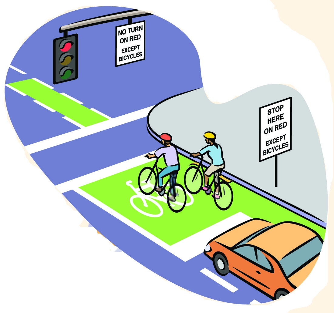
Such efforts being made in these cities include separated on-street bike lanes, enhanced signage, signal timing, and bike boxes which are all intended to make bicycling safer and more accommodating. As a result, Vancouver has seen a ten fold increase in the number of bicyclists using the Dunsmuir Viaduct since its bicycle improvements were made. Bicycling there also represents the fastest growing form of transportation in Vancouver with more than 60,000 bicycle trips each day.
In May 2010, Vice Mayor Roxanne Qualls highlighted Portland, OR’s use of bike boxes as a best practice citing that the new bike boxes at intersections throughout Portland help to eliminate dangerous “right hook” collisions. The bike boxes in Portland are colored green boxes on the road with a white bicycle symbol inside that offers a visual clue to motorists to expect bicyclists at the intersection while also positioning bicyclists in front of motorists so that they are not in the motorist’s blind spot.
Those interested in speaking at the Livable Communities Committee meeting tonight are asked to arrive by 5:50pm to fill out a comment card. Free bicycle parking is available at City Hall which can also be accessed by Metro bus service (plan your trip).