Categories
Development News Transportation

Cincinnati officials are looking for design ideas as they work to cap urban highway

Billions of dollars of public and private investment has transformed Cincinnati’s central riverfront over the past decade. What was once a flood-prone industrial center turned unusable waterfront property, is now home to a new park, neighborhood, museums, and professional sports venues.

The investments made to date have been so successful, in fact, that they are creating spinoff investment in the Central Business District. A remaining hurdle, however, is the crossing of Third Street, Fort Washington Way (FWW), and Second Street.

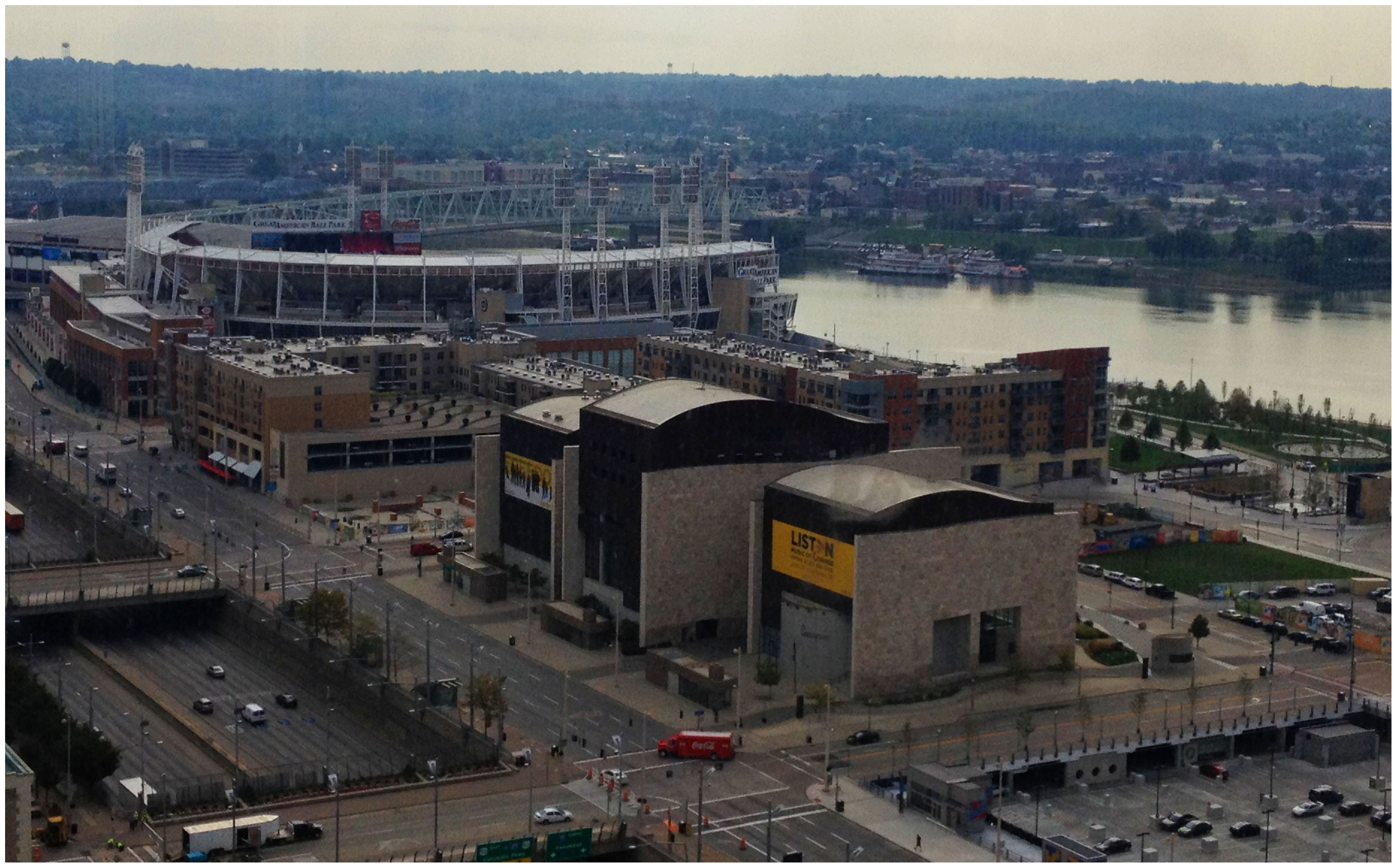
The nearly 300-foot span of roadways was significantly reduced in width when Fort Washington Way was reconstructed in 2001, but the span remains a visual barrier for many of those in the Central Business District or at The Banks.

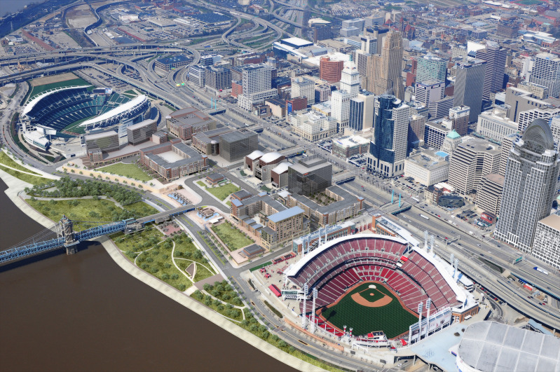
Cincinnati officials are looking to build off of recent success by capping Fort Washington Way. Photograph by Randy A. Simes for UrbanCincy.

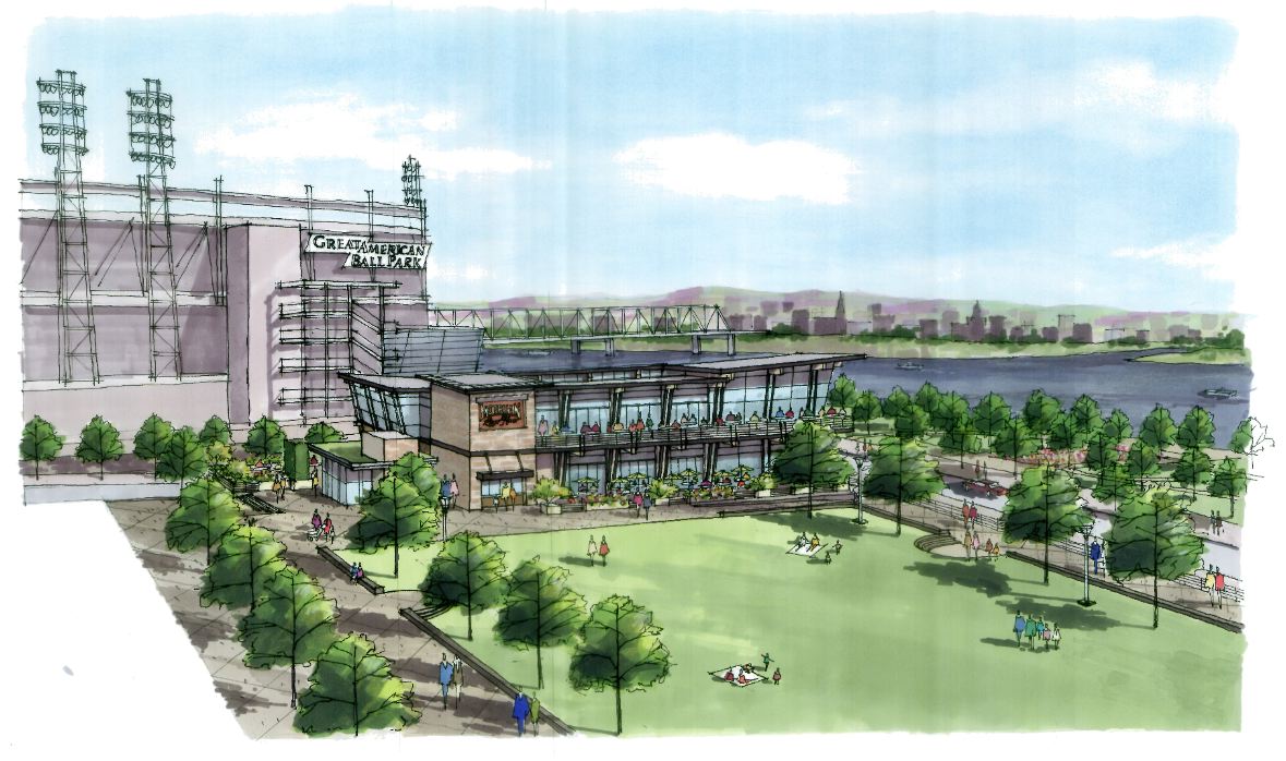
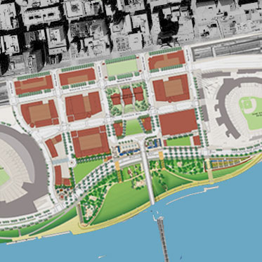
The problem was expected by city officials, in the 1990s, during original planning efforts for the central riverfront’s transformation. As a result, city leaders worked to raise $10 million to construct pile foundations that could one day support a cap over the interstate highway running beneath street level on FWW.

The pile foundations are capable of extending 600 feet over the highway roughly between Elm Street and Main Street. According to engineers who worked on FWW’s reconstruction, the caps could support the weight required for a park, or built structures depending on height and building materials.

No specific development plan for the caps has been developed however, and now the city is launching a design competition called Connect the Blocks to establish a vision for space.

“The Banks is well underway, downtown is growing, and now we must begin thinking about what we as a community want to see over Fort Washington Way to connect downtown and the riverfront,” City Manager Milton Dohoney stated in a prepared release. “We must first have a common vision of what we want, then we can establish the roadmap to get there.”

The national competition is calling on architectural, engineering and design professionals to create and submit concepts and cost estimates for the caps that are to be built over FWW. According to city officials, three to five finalists will be selected and awarded stipends to further refine their designs.

St. Louis has dealt with similar issues as it has tried to bridge the divide created by I-70 between downtown and the Gateway Arch grounds. While I-70 will not be capped entirely, a one block portion is envisioned to connect Jefferson National Expansion Memorial with Kiener Plaza in the CityArchRiver 2015 plan.

In Ohio, the only similar example of such a project exists in Columbus where a $7.8 million cap was constructed over I-670 along N. High Street. It includes approximately 25,000 square feet of street-level retail and connects Columbus’ downtown with its Short North district.

The City of Cincinnati held the first of two public meetings, on the design competition, last Wednesday in Madisonville. The second meeting is scheduled to take place on Tuesday, October 9 at 6pm at the Main Public Library (map). The public is also invited to weigh in on the process by participating in an online survey going on now, and officials also say that the public will be invited back to view the finalists’ designs once they are selected.

Full details about how to participate in the eight-month design competition can be found on the project’s website. The implementation of any winning design, officials say, will be dependent upon the availability of funding.

Categories
News Opinion Transportation

The time is ripe for a central intercity bus terminal in Cincinnati

Megabus is experiencing tremendous ridership growth throughout the Midwest, and is working to expand their intercity bus service to and from places like Cincinnati. In 2010 the company experienced amazing growth of 65 percent and now records $100 million in business annually on 135 buses to 50 different U.S. cities daily.

The growth has been so profound that the company has spawned the “Megabus effect” which is driving up ridership for providers such as Greyhound and BoltBus. And cities all across the U.S. are scrambling to offer prime locations for Megabus to utilize.


Megabus picks up passengers at 4th & Race Street in downtown Cincinnati – Photograph by Thadd Fiala for UrbanCincy.

The European-based company prides itself on its low fares, and does so in part through its low overhead. The intercity bus service accomplishes this by picking up and dropping off passengers along the street. Thus no facility or overhead costs are needed for their operations, but passengers must deal with inclement weather and lack of waiting area typically provided at other transport facilities.

Greyhound historically located its facilities on the edges of downtowns in otherwise rundown areas. This model is changing though as Greyhound attempts to attract new choice riders to its operations. The new Greyhound Express services include buses similarly equipped to Megabus and BoltBus.

Fortunately for Cincinnati, city leaders have an underutilized piece of infrastructure built beneath 2nd Street. The $18 million Riverfront Transit Center (RTC) was completed in 2002 as part of the reconfiguration of Fort Washington Way (FWW), and has sat there rarely used ever since. Its presence presents the opportunity for Cincinnati to create a consolidated bus terminal in the heart of its urban core without negatively impacting the quality of life of those around it.


Riverfront Transit Center interior photographs by Ronny Salerno.

The opportunity of both bus service providers being able to locate within a consolidated, covered and modern facility in the heart of Cincinnati’s downtown would seem to be attractive. Passengers could wait inside and out of the elements; hotels, shops and restaurants would greet arriving passengers above at The Banks; easy access to local bus and streetcar service would be available, and the providers would have a protected area to park their buses.

Meanwhile, the city would be able to finally utilize one of its most unique pieces of infrastructure. Future bus service providers could also tap into the RTC until capacity is reached. This would allow the Queen City to have a centrally located, consolidated intercity bus terminal convenient to travelers and beneficial to service providers.

Financing of maintenance costs would have to be determined, but a deal on Greyhound’s land and some sort of a license fee agreement with Megabus and others could be reached to help offset costs.

Building the RTC today would most likely prove to be cost prohibitive. Fortunately, city leaders had the foresight to build this piece of infrastructure beneath 2nd Street. City leaders should move to free the already congested 4th Street of Megabus operations, open up land adjacent to the city’s new casino for future economic development, and establish a center that will facilitate the addition of other intercity bus service providers.

Categories
Business Development News

Cincinnati’s dramatic, multi-billion dollar riverfront revitalization nearly complete

[This op-ed was originally published on The Urbanophile on July 13, 2010.  Visit the original op-ed for more comments, thoughts and opinions on the matter of Cincinnati’s dramatic riverfront revitalization effort over the past two decades – Randy.]

Several decades ago Cincinnati leaders embarked on a plan to dramatically change the face of the city’s central riverfront. Aging industrial uses and a congested series of highway ramps was to be replaced by two new professional sports venues, six new city blocks of mixed-use development, a new museum, a central riverfront park, and parking garages that would lift the development out of the Ohio River’s 100-year flood plain.

Paul Brown Stadium, home of the Cincinnati Bengals, was one of the first pieces of the puzzle to fall into place. The $455 million football stadium kept the Bengals in Cincinnati and has received national praise for its architectural design while also entertaining sold-out crowds.

The next piece to fall into place was the reconstruction of Fort Washington Way which consolidated the stretch of highway and opened up land critical for the construction of yet another stadium and the mixed-use development which became known as The Banks. The 40% reduction in size was not the only accomplishment though. The reconstruction project also included the Riverfront Transit Center designed to one day house light rail connections and a sunken highway that could be capped with additional development or park space.

Following the reconstruction of Fort Washington Way, Riverfront Stadium was then partially demolished to make room for the construction of the $290 million Great American Ball Park. Once complete, Great American Ball Park began entertaining baseball fans at 81 home games each year and at a new Reds Hall of Fame & Museum. The new venue eliminated any need for Riverfront Stadium and thus led to its implosion in 2002.

The removal of Riverfront Stadium then freed up room for the construction of the National Underground Railroad Freedom Center atop the first piece of a two-deck parking garage intended to both lift the new riverfront development out of the flood plain, and provide enough automobile parking to replace what was previously there in the form of surface lots and satisfy new parking demands created by the development.

The most recent piece of the puzzle has been the development of the initial phases of both the Cincinnati Riverfront Park and The Banks. The two separate projects are developing in complimentary fashion and are on similar time tables, and are both developing east to west from Great American Ball Park to Paul Brown Stadium. Recent news will add a modern streetcar line running through The Banks development that will transport people from the transformed riverfront into the Central Business District, Over-the-Rhine and beyond to Uptown.

The 45-acre, $120 million Cincinnati Riverfront Park is expected to become the crown jewel of an already nationally acclaimed Cincinnati Park System. The Banks meanwhile will bring thousands of new residents, workers and visitors to Cincinnati’s center city. The initial phase of both projects is expected to be complete in spring 2011 and will include 300 new residences, 80,000 square feet of retail space, Moerlein Lager House, Commuter Bike Facility, additional components of the two-deck parking garage, and the first elements of the park.

The transformation of Cincinnati’s central riverfront from aging industrial space to a vibrant mixed-use extension of downtown is not complete, but the two-decade old, $3 billion vision is finally nearing reality. And with full completion expected in the coming years, one of the remaining traces of Cincinnati’s industrial past will be replaced by a new vision for a 21st Century city and economy.

Categories
Month in Review

Month in Review – July 2010

Christian Moerlein Lager House

July was an exciting month in Cincinnati, with lots of news on major construction projects in the urban core. The Cincinnati Streetcar received a large federal grant, meaning construction will begin this fall. There were articles on Great American Tower, which is nearing completion, and the Christian Moerlein Lager House brewpub, now under construction in the Cincinnati Riverfront Park. David Ben completed his four-part series on how the reconstruction on Fort Washing Way in the late 1990s is paying off today.

UrbanCincy’s top 5 articles for the month of July were:

  1. Moerlein Lager House to open August 2011, new details announced
    The $4 million restaurant and microbrewery will boast a large outdoor biergarten capable of seating 600 people in addition to the 500 people that can be held inside the restaurant…
  2. Cincinnati wins $25M Urban Circulator grant for modern streetcar project
    Cincinnati’s modern streetcar project has won a $25 million federal grant through the Urban Circulator Systems program. The grant was announced by Transportation Secretary Ray LaHood and Federal Transit Administrator Peter Rogoff as they awarded $293 million in federal funding for 53 transit projects nationwide…
  3. Fort Washington Way

    Great American Tower rises triumphantly above downtown Cincinnati
    Crews from Turner Construction Company continue to work on the finishing touches of Cincinnati’s new tallest skyscraper that will house a variety of companies including Great American Insurance for which the Great American Tower gets its name…

  4. Reconstruction of Fort Washington Way Redefined Cincinnati’s Urban Core
    The major change in the 1998 redesign came by untangling and streamlining the mess of highway on- and off-ramps. Doing so allowed the roadway to carry a greater capacity, increase safety, and dramatically decrease the total width of Fort Washington Way…
  5. Hidden Assets of Fort Washington Way Saving Taxpayers Millions of Dollars
    Those who enjoy spending their summer evenings at Great American Ball Park to watch our first-place Reds have probably seen the stairway entrances to the Riverfront Transit Center. Below Second Street, along the southern portion of FWW, lies an underground multi-modal transit facility…
Categories
Development News Politics

Fort Washington Way caps to provide valuable real estate

Each Wednesday in July, UrbanCincy has highlighted Fort Washington Way (FWW), the I-71/US-50 trench bisecting the Cincinnati’s central riverfront from its central business district. Part one of the series discussed what the area looked like prior to reconstruction a decade ago, and how that reconstruction made way for the development along Cincinnati’s central riverfront. Part two discussed some of the unseen assets included in the project that are saving taxpayers millions of dollars. Last week’s article highlighted even more of the unique features that contributing many societal benefits to the region. To conclude the series, this week will feature ideas for future development around Fort Washington Way.

When the stretch of highway was redesigned a decade ago, the better design allowed for several acres of space to be reclaimed for uses that are more productive than a highway. The National Underground Railroad Freedom Center was located on land that was once a highway, as are portions of The Banks development which is currently under construction. Plans for the second phase of The Banks also will make use of the reclaimed land from the redesign. The Banks, bookended by our major league stadia and highlighted by the Freedom Center, is a development project that will fundamentally transform this city’s urban core. It was only made possible through redesigning the stretch of highway and reclaiming under-utilized land on Cincinnati’s urban riverfront.

When the Federal government chose to build I-71 through downtown Cincinnati, they chose to do so in an area that already had a major roadway on it. As a result, local authorities were allowed to maintain the rights to the space directly above the federal highway. Generally, when the Federal government builds highways, they maintain the air rights so that they can better control the factors that impact the highway’s utility. In this case, Cincinnati’s ability to maintain control over these rights ensures that the area can be used to its maximum local utility.

To maximize the utility of the space, officials could choose to install 600 feet-long caps over the highway. As has been discussed previously in this series, the reconstruction of Fort Washington Way ten years ago included building infrastructure necessary to support such caps. Structurally, these caps could support several feet of dirt, allowing the city to create a fascinating, unique pocket park in the heart of downtown Cincinnati. Nearby residents would benefit greatly from a place to walk their dogs. Having the retail, office, and residential space at the Banks surrounded by green space on the south with the new riverfront park and on the north with a park above the highway could provide a stunning and dramatic space.

However, some view more park space in that location as unnecessary, and that the real estate in that particular location is too valuable to be planted over. As a result, it is likely in the city’s best interest to explore options that would generate tax revenue. According to engineers responsible for the project, the caps could be built in such as way so that developers would not be restricted with the building materials they use. However, as the height of a building increases, so too does the building’s weight. As a result, buildings on the caps would likely be limited to about four stories in height.

With that particular height, the new development would provide an aesthetic feature that would visually link The Banks to the rest of the central business district. When the first phase of The Banks is complete, portions of mixed-use development will rise six stories above Second Street. Directly to the north of this area sits the trench of Fort Washington Way, followed immediately by highrises like the E.W. Scripps Tower and Cincinnati Enquirer Building. Developers could opt for a design on the caps that would have first floor restaurant or retail options, with offices or residents above.

One of the worst features of the old Fort Washington Way that the new design did not completely fix is that the highway bisects downtown from the Ohio River. Capping the highway and building several-story, mixed-use buildings on it would go a long way to rectifying that disconnect. Because of the required space between the current bridges over the highway and the caps, entrances to these buildings would have to be from Second or Third Street. This particular design would allow comfortable transition north and south between the waterfront and downtown, but would also keep pedestrians moving east and west in the city.

A task force of engineers recently convened to study the feasibility of building and installing these caps. Their task not only includes determining the exact structural capabilities, but also projected costs. Armed with this information, city officials and developers could begin discussions shortly. Should the city push for a unique park over the highway? Or would you rather see a the area built with multi-use buildings?