Like any major city, Cincinnati owns and operates a lot of vehicles, and those vehicles produce a significant amount of carbon emissions that pollute the region’s environmental systems. As city leaders are working on implementing a 100 percent renewable energy plan, they are also developing a plan that would end the city’s dependence on gasoline or diesel motor fuels by 2025.
“There are a lot of things Cincinnati is doing to position itself as a leader in sustainability and going green – both in the public and private sector,” said Larry Falkin, director of Cincinnati’s Office of Environmental Quality (OEQ). “This is part of a total package, and a significant piece, in terms of branding Cincinnati as a progressive city.”
Action on the new Green Fleet Plan was made possible, Falkin says, when City Council approved phase one of the City Fleet Plan in November 2011. The Green Fleet Plan is being developed for the City’s 3,654 vehicles and is expected to be finished by mid-2012.

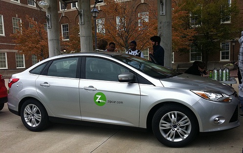
A Zipcar sits on display at the University of Cincinnati’s main campus uptown. Photograph by 5chw4r7z.
According to a 2011 report, the City’s existing vehicle fleet has an average age of seven years and has a median fuel efficiency of 12.15 miles per gallon. Over the course of a year those vehicles consume more than two million gallons of fuel with more than 95 percent coming from gasoline and diesel. City officials expect their current annual fuel cost of $5.1 million to continue to rise s gasoline prices are expected to escalate in the near future and maintain high prices over the long-term.
Another partial solution presented itself in September 2011 when Zipcar entered the Cincinnati market. Prior to the carsharing company entering the Cincinnati market, discussions about whether the City could leverage such a service were taking place.
The idea would be that the City could contract with Zipcar to provide a certain number of vehicles in the city and the city would then utilize the service for quick runs when employees need to be on-site for inspections or other service calls. The service would not completely eliminate the need for city-owned vehicles, but it is envisioned as lessening the need for the city to own as many automobiles.
“The City is interested in starting a city carsharing service within the city, and we are currently in negotiations with Zipcar,” Falkin told UrbanCincy.
Falkin says that original negotiations came to a halt when the City realized there were purchasing requirements to which it had to adhere. As a result, Falkin says, the City will be moving forward with these discussions but will be looking at a competitive bidding process that will engage more than just Zipcar.
Currently more than half of all of the City’s vehicles are past their current life cycles. Based on original equipment values, it is estimated that to replace the entire fleet would cost approximately $50 million. $5.2 million was budgeted for vehicle replacement in 2012.