Categories
Development News

Columbus is not the biggest city in Ohio, and Indy’s not bigger than Boston

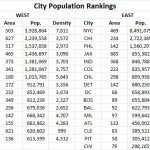
Following the release of the U.S. Census Bureau’s updated population numbers for American cities, much has been made about the urban rise of the west. Even the Census Bureau itself touted the growing number of cities with more than 1 million people – the vast majority of which are located west of the Mississippi River.

These numbers can be misleading, and often don’t even pass the smell test.

Is Jacksonville, for example, really a bigger city than Detroit, Washington DC, Atlanta and Boston? Or out west, would most people actually consider Phoenix to be a larger city than San Francisco, Seattle, Denver or San Diego? Of course not.

In both scenarios, however, that is precisely the case. That is because the municipal boundaries for Jacksonville (885 square miles) and Phoenix (517 square miles) are disproportionately large compared to the population of their city. Closer to home the same is true for Columbus (223 square miles), Indianapolis (368 square miles) and Charlotte (298 square miles) – all of which skew the average population density for cities east of the Mississippi downward due to their huge municipal footprints.

If you were to simply pick-up a daily newspaper and read the listing of America’s most populated cities, you would not get this full perspective and perhaps be misled to think that Columbus is the biggest city in Ohio, or that Indianapolis is the fifth largest city east of the Mississippi River.

Using this same practice, some might consider Cincinnati to be a small city that doesn’t even crack the top 30 in the United States.

Of course, we know all of this is skewed by all sorts of factors. Some cities sit on state or county lines, others follow historical boundaries from hundreds of years ago that have never changed, while other are granted more liberal annexation capabilities. In short, it’s politics.

Now if we were to look at America’s 30 most populous cities again, but rank them by population density instead of overall population, the picture would change rather dramatically. Most cities in the west fall considerably, while older cities in the east would rise. The outliers that have artificially inflated their boundaries over the years also fall into a more normalized position on the chart.

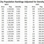
While Cincinnati is not in the top 30 in terms of population, we considered it anyways since this is UrbanCincy after all. After adjusting for population density, Cincinnati would vault all the way to the 16th “biggest” city in America, just behind Denver and ahead of Dallas. This is also more in line with Cincinnati’s metropolitan population ranking that falls within the top 30 in America.

Those cities in this analysis that are in the east have an average population density, outliers included, of 6,579 people per square mile, while those in the west, come in at 3,804 people per square mile.

If outliers like Jacksonville actually were as large as they project, and followed the average population density for the region, it would need to add close to 5 million people. Likewise, Indianapolis would need to add around 1.6 million people and Charlotte 1.1 million. Local politics and market conditions in each of these cities will never allow for this many new people to move within city limits.

The Washington Post is correct in that the west is getting more populated and urbanizing at a fast pace, but let’s not get ahead of ourselves. The most populated cities in the west would only be average, at best, in the east if they were judged by population density instead.

Now, factoring for population-weighted density would be an entirely different ballgame.

Categories
News Opinion

CNU23: Unsure About Expectations, Dallas an Unexpected Delight

I saw my first cowboy hat within my first five steps off of my Frontier Airlines flight into Dallas/Fort Worth International Airport.

The truth is, I didn’t really know what to expect from Dallas – hell, I’d never even been to Texas. What I found during last week’s visit was a clean, cosmopolitan city filled with music, art, and a personable populace that exceeded my expectations.

Things didn’t get off to the best start. I had to spend a couple of hours at the airport waiting for my girlfriend’s flight to arrive. Leaving Terminal E for the train at Terminal A, the Terminal Link bus felt, indeed, terminal, as it would its way through an unintelligible maze of ramps and roadways.

We then faced another hour on Dallas Area Rapid Transit‘s (DART) Orange Line to our accommodations, the historic Hotel Lawrence in the West End of Dallas. I would not recommend this hotel unless you’re looking for something cheap and you’re not planning on being there much, because it’s currently under a heavy renovation to rebrand it as a LaQuinta Inn & Suites and won’t be completed until early next year. But it is served by several bus lines, is across the street from Dallas Union Station, and is a short walk from Dealey Plaza and the Sixth Floor Museum, which is located in the building from which President Kennedy was shot. Oh, and the 561-foot Reunion Tower (1978), where for $16 you can access the GeO-Deck. (I declined.)

(Tip: Buy a 7-day DART pass for $25 and enjoy unlimited rides on all trains and buses!)

I was in town for CNU23, which was being held downtown at the beautiful Hotel Adolphus (1912) on Commerce Street. The first two days were spent getting to know writers from other Streetsblog affiliate sites and brainstorming ways to build better stories, better sites, and a better national network. We also traveled to the adjacent Deep Ellum neighborhood, which, with its restaurants and bars, would be considered the city’s hipster enclave. While there, we heard a presentation on tactical urbanism and took part in a project to build seating out of reclaimed wood pallets for a street festival.

The rest of the conference – which was extremely well-run, by the way – was focused heavily on transportation and designing around transit. Called “Meeting the Demand For Walkable Places”, the conference featured speakers presenting on topics ranging from in-depth to broad, tours of place making initiatives that are working, and meet-ups.

I will say that the architecture in Dallas left me a bit wanting. Many of the downtown buildings are constructed in the modern/brutalist and postmodern styles, indicative of the postwar boom that saw the city grow from a population of under 300,000 in 1940 to an estimated 1.3 million today. But there are pockets of “old” Dallas here and there, and numerous public plazas from which to enjoy them.

(Note: Yes, there is a McDonald’s with a drive-thru in downtown Dallas!)

On the way back to the airport on Friday, I was able to get a good look at some transit-oriented development near the Orange Line’s Victory station (near the American Airlines Center) and the massive planned community of Las Colinas in neighboring Irving.

The airport was no better the next day.

I would definitely recommend Dallas. The people were fantastic, the food was great, and the positive vibe was palpable. It may have just been the great minds that were in town for the conference, but, if it’s even half as nice on a daily basis, I’d still enjoy it. And the “CVB” weather made it all the more enjoyable.

CNU24 will take place June 8-11, 2016 in Detroit. I’ve been to Detroit several times, but not for a few years. Perhaps it will be time to visit again.

Categories
News Transportation

All Aboard Ohio Celebrates Recent Successes, Future Plans at Recent Meeting

Last Tuesday, All Aboard Ohio held their Spring meeting at the newly-opened Taft Ale House in Over-the-Rhine.

President of the Southwest chapter, Derek Bauman, ran the meeting, which not only included discussion of advocacy for interstate passenger rail in Cincinnati, but also of the ongoing construction of the Cincinnati Streetcar.

Several community leaders and representatives were present, including Streetcar Project Manager John Deatrick, Metro’s Rail Operations Manager Paul Grether from Metro, the chief of staff for Councilman Kevin Flynn, a representative from the Cincinnati Preservation Society, the president of Queen City Bike, and even Cincinnati Union Terminal’s Amtrak station manager.

To begin the meeting, Deatrick and Grether talked about the construction of the streetcar system, which can be seen directly outside of Taft’s Ale House, and the future operation of it. Deatrick informed the crowd that almost 70% of the construction is complete, which is ahead of schedule, and the city expects the first streetcar delivery by September.

When asked to address the ongoing discussion about the next phase to Uptown, Deatrick declined to comment.

Grether then explained how his organization acts as the conduit for federal funds to the streetcar and will be the future operator of the system. He also discussed Metro’s plans to schedule the streetcar in a manner that complements and fully integrates with Metro’s bus operations, and those of TANK.

Another key point that Grether mentioned is that the technology is in place to be able to give streetcars signal priority, should leaders at City Hall decide that is desirable. Such a move would quite significantly improve travel times and performance.

As the conversation moved on, Bauman spoke about the group’s efforts to establish daily passenger rail service between Cincinnati and Chicago. Not having daily rail service to Chicago damages business competitiveness for the city, Baumann said, considering that Milwaukee, St. Louis, Detroit and Indianapolis already currently boast such service.

The effort has received renewed interest as of late due to the debate surrounding the future of the Hoosier State line, which connects Chicago to Indianapolis. Project proponents scored a big win recently when funding was picked up by the State of Indiana to continue its service. Those efforts even attracted the attention of Senator Joe Donnelly (D-IN) in a letter he penned to the Federal Railroad Administration about the possibility of future extensions of the line.

Since assuming the presidency of the local chapter, Bauman has made a variety of changes to allow for greater participation and engagement. Meetings are no longer confined to members, for example, and they have begun reaching out to the business community and area universities.

Bauman said that he hopes this approach will help make daily passenger rail service a reality for the Cincinnati region at some point in the near future.

Those that are interested in supporting the efforts of All Aboard Ohio can do so by making a tax-deductible donation to the organization on Tuesday, May 12. On this day the Columbus Foundation will make matching donations to a collection of non-profits throughout the state, including All Aboard Ohio. You can make secure donations to the group on their website.

Categories
Up To Speed

Is the Great Lakes region ready to start acting like a megaregion?

Is the Great Lakes region ready to start acting like a megaregion?.

Only a small piece of land between Cincinnati and Dayton remains undeveloped, and many believe that remaining gap will disappear very soon. But the merging of Cincinnati and Dayton as one large metropolitan region is only part of the story, as shared regional identities with other large urban centers throughout the Great Lakes region becomes more pervasive. This and other regions like it around the U.S. are becoming even more centralized. More from The Week:

Though the concept has existed in academia for decades, planners are now looking at these dense corridors of population, businesses, and transportation and wondering if the megaregion may, in fact, be the next step in America’s evolution. With renewed interest and investment in urban centers and the projected growth of high speed rail, megaregions could easily become home to millions more Americans.

The Northeast corridor, for example, could receive up to 18 million more residents by 2050, according to estimates from the Regional Plan Association. And the region encompassing major cities in Texas including Houston and Dallas could see a spike from roughly 12 million to 18 million people in that same time, the association says.

And where population goes, economic growth is not far behind. The Northeast corridor would be the fifth largest economy in the world, with the Great Lakes megaregion at ninth and the Southern California megaregion outpacing Indonesia, Turkey, and the Netherlands as the 18th largest, according to 2012 estimates from real estate advisory RCLCO. The problem is, there are challenges to making these networks hold together. Unlike megaregions in Europe and Asia, for example, the United States has traditionally shied away from large umbrella governing organizations which surpass state borders.

Categories
News Opinion Transportation

GUEST COMMENTARY: How Personal Finances Factor Into Home-Work Commute

The recent Brookings study looking at “job growth” and “jobs near the average resident” got me thinking again about how my past two home and workplace decisions have affected my personal finances. For those not familiar with the report, it’s mostly negative news:

Between 2000 and 2012, the number of jobs within the typical commute distance for residents in a major metro area fell by 7%. Of the nation’s 96 largest metro areas, in only 29—many in the South and West, including McAllen, Texas, Bakersfield, Calif., Raleigh, N.C., and Baton Rouge, La.—did the number of jobs within a typical commute distance for the average resident increase. Each of these 29 metro areas also experienced net job gains between 2000 and 2012.

As employment suburbanized, the number of jobs near both the typical city and suburban resident fell. Suburban residents saw the number of jobs within a typical commute distance drop by 7 percent, more than twice the decline experienced by the typical city resident (3%). In all, 32.7 million city residents lived in neighborhoods with declining proximity to jobs compared to 59.4 million suburban residents.

As poor and minority residents shifted toward suburbs in the 2000s, their proximity to jobs fell more than for non-poor and white residents. The number of jobs near the typical Hispanic (-17%) and black (-14%) resident in major metro areas declined much more steeply than for white (-6%) residents, a pattern repeated for the typical poor (-17%) versus non-poor (-6%) resident.

Residents of high-poverty and majority-minority neighborhoods experienced particularly pronounced declines in job proximity. Overall, 61% of high-poverty tracts (with poverty rates above 20%) and 55% of majority-minority neighborhoods experienced declines in job proximity between 2000 and 2012. A growing number of these tracts are in suburbs, where nearby jobs for the residents of these neighborhoods dropped at a much faster pace than for the typical suburban resident (17% and 16%, respectively, versus 7%).

For local and regional leaders working to grow their economies in ways that promote opportunity and upward mobility for all residents, these findings underscore the importance of understanding how regional economic and demographic trends intersect at the local level to shape access to employment opportunities, particularly for disadvantaged populations and neighborhoods. And they point to the need for more integrated and collaborative regional strategies around economic development, housing, transportation, and workforce decisions that take job proximity into account.

Now looking at this from a personal finance perspective, I previously lived and worked in Indianapolis where my one-way commute was roughly 16 miles. For this distance, I found over time that it cost me about $5 a day to get to work.

When I moved to Cincinnati for a new job, I first lived in Covington where I paid $1 to ride the Southbank Shuttle in the morning and usually walked home. After moving to Clifton, I still found that my now driving commute of less than 3 miles came to cost around $1 per day.

So the $5 per day Indianapolis commute cost me roughly $100 per month in gas, where the $1 per day Cincinnati commute cost me only $20. Now this may not seem like a huge amount or difference, but to most people, $80 would nearly be a full day’s work. What’s not reflected in this difference is the reduced frequency and cost related to vehicle maintenance, specifically oil and tire changes. With the greatly reduced frequency of need for these two items, the monthly savings I’ve found is closer to the full $100 amount, essentially a pay raise simply for living close to work.

Employees obviously can have little impact on where an employer chooses to locate, but they do still have control over where they live and as long as I am able, 3 miles is the maximum distance I will live from work. This distance is also interesting as I’ve found it to be the maximum distance where taking the bus is a reasonable time-cost choice, a huge benefit during the recent snowy winters, and it is also a distance where my non-work trips to downtown stay at what I think is a reasonable level for places I like to visit.

EDITORIAL NOTE: This guest commentary was authored by Eric Douglas, a native of Grand Rapids, MI who currently lives in Cincinnati’s Clifton neighborhood. Eric is a member of the Congress for New Urbanism and earned a Bachelors of Science from Michigan State University. Since that time he has worked for Planning, Community Development and Public Works departments in Cincinnati, Indianapolis and Detroit.

If you would like to have your thoughts published on UrbanCincy, simply contact us at editors@urbancincy.com.