Categories
Business News Politics

National Citizen Survey Shows Perceptions of Hamilton Continue To Improve

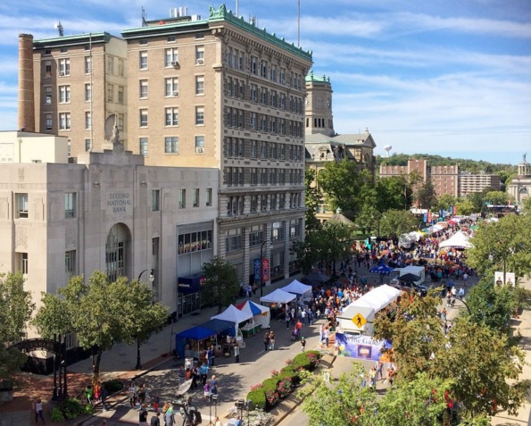
With the recent announcements of two major new employers, London-based Barclaycard and Colorado-based StarTek, bringing hundreds of new jobs to Hamilton, it may come as no surprise that the city performed comparatively well on the 2015 National Citizen Survey.

Made available to residents in nearly 550 other localities throughout the United States, the NCS is considered by most counties and municipalities as the standard-bearer for collecting meaningful qualitative data and providing informative, actionable feedback.

At the survey’s conclusion, each participating community received an in-depth report that summarized their residents’ responses in three areas: community characteristics, governance and participation. In aggregate, these are compiled to give a general overview of the community’s livability and quality of life. Embedded within this, the questions collect residents’ thoughts about eight key aspects that are central to any community: safety, mobility, the natural environment, the built environment, recreation/wellness, education/enrichment, and community engagement.

While the comparison to other communities is certainly useful, what’s most telling is how the Hamilton of today compares to the Hamilton of its not-so-distant past.

When lined up against its results from the 2011 NCS, the city saw positive gains in a nearly two-thirds of the survey. Not only did the city improve upon those areas where it had been lagging for decades, it also continued to bolster its status as a high-quality, cost-effective producer of public utilities and public goods.

From its best-tasting water, its increased hydroelectric energy production, to its publicly accessible natural-gas station (the first and only in Greater Cincinnati); Hamilton has proven that it is indeed possible to effectively provide public services through economically uncertain times.

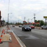
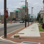
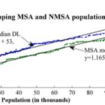
It wasn’t all great news, however, with some of the lowest scores falling within the realm of transportation. In particular, few residents responded positively to questions about public transit and traffic flow, both of which have been notoriously subpar for a city of Hamilton’s size. By comparison, nearby Middletown, which is smaller than Hamilton, has had direct access to Interstate 75 and its own four-line public bus system for decades.

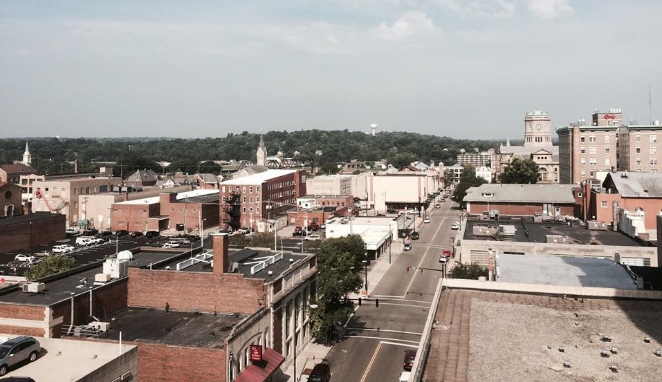
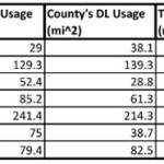
Within the city proper, there are only three bridges that connect the city across the Great Miami River within the city proper, all of which carry local roads. Further complicating this is Hamilton’s lack of any highway-grade road infrastructure of any significance as well as numerous at-grade railroad crossings on both sides of the river.

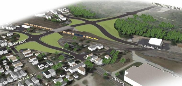
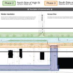
The city is attempting to address some of these transportation issues by moving forward with the $29 million South Hamilton Crossing project, while also lobbying to restore regular passenger rail service.

Public transit of any kind is non-existent in Hamilton, which only frustrates this situation even more. In response to this, city leaders say that they are working to improve relationships with Butler County and other entities within the county, including Middletown and Miami University, to improve public transit offerings.

In particular, the Butler County Regional Transit Authority has essentially absorbed operation of what had been independent bus services in Middletown and Oxford in order to build connectivity among the county’s population centers. BCRTA also maintains routes to West Chester and Tri-County Mall in coordination with Cincinnati’s Metro bus system.

Categories
Development News Transportation

Construction to Start on $29M South Hamilton Crossing Project This March

Hamilton city officials recently celebrated the announcement that Barclaycard would bring up to 1,500 jobs to Vora Technology Park for a new call center. Now, in almost perfect timing, public officials say they are ready to move forward with a $29 million project that will greatly improve access to the site.

Last week the OKI Regional Council of Governments awarded $3.75 million to the South Hamilton Crossing project. This is in addition to a previous allocation of $2.45 million from OKI, and $10 million from the State of Ohio. The remaining funds are coming from the City of Hamilton and Butler County.

“OKI’s support of the South Hamilton Crossing project is crucial to its success and illustrates how important the overpass is to our regional transit network,” City Manager Joshua Smith stated in a prepared release.

Hamilton has long been defined by its numerous freight railways. While they have been productive for the city, they have also served as barriers between neighborhoods since they typically operate at-grade.

The Jack Kirsch Underpass on High Street is the only grade-separated rail crossing in Hamilton that offers east-west flow. As a result, the South Hamilton Crossing has long been envisioned; with some plans showing it that date all the way back to 1911.

As of now, Grand Boulevard terminates at the CSX and Norfolk Southern tracks in Lindenwald. People walking, biking or driving must then head north along Central Avenue and then cut across the four railroad tracks diagonally.

This new project will extend Grand Boulevard to the west to University Boulevard, serving Vora Technology Park and Miami University Hamilton. Instead of crossing the four railroad tracks, the extended road will bridge them, thus offering fewer conflicts for pedestrians, cyclists and motorists, along with fewer restrictions for freight operators.

“SHX is very important for both safety and economic reasons,” said Smith. “With the recent announcement that Barclaycard is opening a 1,500 person facility at Vora Technology Park, the need for better access to the area is more important now than ever.”

Transportation officials say that 56 trains travel through this crossing on a daily basis, which results in its blockage a total of 15.3% of the time. As a result, the new overpass is expected to greatly improve connectivity, reduce travel times, and increase safety.

Project leaders say that construction should begin in March 2016 and be completed in mid-2018.

Categories
Development News

Hamilton Looking For Public Input on Annual Action Plan

Hamilton OHThe City of Hamilton is seeking input from the general public as it prepares its Annual Action Plan for 2016-17 for grants received from the U.S. Department of Housing and Urban Development.

The funds are disbursed to localities throughout the country to help address the needs of low- to moderate-income residents. Some of the programs that are funded fully or in part by these HUD grants include youth services, elderly services, transportation improvements, neighborhood stabilization programs, crime prevention, job training, and much more.

Hamilton qualifies for support due to its higher-than-average poverty rate (22.9%) and its lower-than-average homeownership rate (56.5%).

If you currently live or work, have ever lived or worked, or just generally care about the future of Hamilton, city officials are hoping to get your input on how these resources should be used.

In particular, the 15-question survey asks about the state of housing maintenance, balance of rental and owner-occupied housing, public transportation, social services, historic preservation, infrastructure, and economic development strategies.

The survey takes only a few minutes to complete, and all responses, including those to demographic questions, are kept anonymous and confidential. Any questions should be directed to John Creech at Hamilton’s Department of Community Development at 513-785-7350 or creechj@ci.hamilton.oh.us.

Categories
News Transportation

$8.5M East High Gateway Project to be Completed This Summer

Over the past 15 years, the City of Hamilton has sought to beautify its inner-city by reconstructing the High-Main Street corridor. Along the way, City officials have attempted to use historically sensitive design treatments along what is Hamilton’s most-traveled thoroughfare.

This has meant reversing a decades-long policy agenda of installing more modern-styled public amenities in the hopes that they would encourage the private sector to restore historic buildings, create public interest in visiting downtown, and eventually lead to the rebirth of businesses.

Downtown, from the Great Miami River to MLK Boulevard, was the first district to receive this treatment. Shortly after that, the Main Street business district in historic Rossville, from the river and west to Millville and Eaton Roads, and the connector to the just-recently-constructed Butler County Veterans Highway, between State Route 4 and Fair Avenue.

The most recently completed upgrade was the replacement of the High-Main Street Bridge, which has long been the most-traveled bridge on the Great Miami between Middletown and the Ohio River.

Glaringly missing from these updates, however, was the stretch of High Street between MLK and Route 4, which is actually the primary entry for most visitors to the city. Recognizing the irony, City officials decided to begin the process in 2011 to secure funding to give it a much-needed facelift.

Dubbed the East High Gateway, it will extend the historic district overlay from downtown in the hope that the improvements will have the same positive effect on public perception and business investment that prior streetscaping projects have had when finished. City officials also plan to create a land bank for the area that will help the city return under-utilized parcels into better-use, tax-generating properties.

Originally slated for completion in mid-2014, the 15-month-long construction effort is now expected to be finished later this year. The $8.5 million project includes the installation of brick-lined sidewalks with bioswales, new street lighting, landscaped medians, and alley-like access to businesses along the route. It will also involve burying overhead utilities and upgrading existing underground utilities.

Project officials also hope that the changes improve the flow of traffic for those commuting from the more-residential west side of the city.

The East High Gateway is being paid for through a combination of city and state funds, and with support from the Hamilton Community Foundation. Ongoing project updates can be tracked by following @EastHighGateway on Twitter.

Categories
Development News

Cincinnati Scores Slightly Better Than National Average on Sustainable Use of Land

Three percent of the Earth’s surface is developed land, not including farmland. While this may seem like a small percentage, it is the type of development that has created major problems for sustainable living conditions.

With an emphasis on single-family residential developments, auto-oriented planning, and an enormous supply of open land, it has become common knowledge that American cities are more sprawling than their global counterparts. These development patterns, although not entirely confined to the United States, are unique to American planning and have resulted in more sprawl and less sustainable development over the years.

This can plainly be seen by comparing dense European suburbs to American post-WWII sprawling suburbs. Further emphasizing this point today is that while the European Union has identified the percentage of developed land as one of 155 sustainable development indicators in terms of humanity’s ecological footprint, the United States has only noted its land use patterns but not used them as a factor in planning.

A new study, released in March by environmental engineering professors Dr. Giorgos Mountrakis and Dr. George Grekousis at the SUNY College of Environmental Science & Forestry, confirms the premise that America’s population growth does in fact consistently result in increasing land consumption, with the results varying between different states and counties where land management policies differ.

Their study used satellite imagery of the contiguous United States to measure the exact amount of developed land (DL) in 2,909 counties, excluding the outliers in the 100 least populated and 100 most populated counties. They then compared imagery from 2001 to the 2000 Census count in order to rank each county on what they call its DL efficiency. To make for more accurate comparisons, they then compared the results of each given county to the 100 counties closest to it in size (50 smaller and 50 larger).

Using this standard measurement, when Hamilton County was measured it came in at 43rd in its peer group. In this study, those counties with higher scores are considered to be more inefficiently developed. This means that Hamilton County came in slightly ahead of the curve when compared to its peers, which had an average rank of 51.

While the study shines a light on population growth and development patterns, it also reveals several socio-economic differences between similarly sized counties. Perhaps the most significant finding was that there seems to be a linear correlation between DL usages and population growth. For example, the researchers found that population growth of a county can be estimated by comparing its current DL usage to its past usage to then produce an estimate within a 95% confidence level. The larger the city gets, the more sprawling it will become at a consistent rate.

The study also confirmed that, compared to other developed countries, the United States is more inefficiently developed and that American cities tend to grow horizontally as population rises instead of vertically.

With this in mind, the report projects that the anticipated 30% population growth, between 2003 and 2030, will result in a 51% increase in land consumption. This equates to 44.5 million acres of land converted to residential and commercial development, and follows a trend of Rural Non-Metropolitan Statistical Areas developing land at nearly twice the rate of urban and suburban Metropolitan Statistical Areas.

One of the commonalities amongst low land consumption MSA counties, the SUNY researchers found, was that they were mostly located in states and cities with stronger planning agencies and urban growth boundaries. Furthermore, nearly all of the cities in these counties also had experienced rapid growth pre-automobile.

With a ranking of 43, Hamilton County comes in slightly better than the national average in its peer group. Elsewhere in Ohio, Clermont County ranked at 20 in its peer group, perhaps due to its makeup of 19th century towns and propensity of farms. And reflecting the dominance of post-war suburban housing, Butler and Warren Counties bring up the back of the pack at 62 and 55, respectively.

The three urban counties in Northern Kentucky, meanwhile, followed the larger trend for Kentucky overall and were found to be very efficient in their land use when compared to their peer groups.

For comparison, the Cincinnati metropolitan region as a whole scored better than those in Seattle, St. Louis, Kansas City, Orlando, Oklahoma City and Charlotte.

When Cincinnati’s population peaked in the mid-1950’s, it had over 500,000 residents within the city limits, while that number stood at just under 300,000 in the 2010 Census. This means that as the urban core continues to revitalize and add population, land that has become underutilized or abandoned will have the potential to be redeveloped, adding to the city and county’s density, and thus further improving its ranking.