Categories
News Politics Transportation

Three hybrid buses to be added to Metro’s fleet

The Southwest Ohio Regional Transit Authority (SORTA) will debut three new hybrid buses on Thursday, August 5.  The new buses will join a Metro bus fleet that is seeing the number of environmentally friendly buses grow with the help of federal funding through the American Recovery & Reinvestment Act (ARRA).

“As Metro’s fleet gets greener, Cincinnati’s air gets cleaner” said Marilyn Shazor, Metro’s CEO. “Mass transit itself is an important and easy way to go green, and our hybrid buses illustrate our system’s commitment to environmental responsibility.”

Metro officials have estimated that in the first year of operation, the existing six hybrid buses have reduced greenhouse gases by 190 tons, provided 330,000 “green” rides, traveled 210,000 miles, and saved the transit agency 7,000 gallons of diesel fuel.

The savings are particularly important as transit officials look to deal with fewer people riding transit due to the economy, and lower financial contributions from the City of Cincinnati’s earnings tax which contributes 3/10th of one percent of that tax. In addition to the economic benefits, officials see the growing hybrid fleet as a positive for the local environment.

“Smog is a problem in the Cincinnati area and Metro’s purchase of cleaner, lower emission buses is a positive step toward helping clean up our air,” said Cory Chadwick, Director of the Hamilton County Department of Environmental Services. “In fact, everyone can help by increasing their use of public transportation, especially by choosing to ride a diesel-hybrid bus with significantly lower exhaust emissions, better fuel economy, and a quieter ride than a standard diesel bus.”

The new hybrid buses will be on display at Ault Park (map) from 10am to 11am, and on Fifth Street between Walnut and Main (map) from 12pm to 1pm. Metro now has nine hybrid buses in its fleet, with another four to be added in fall 2010.

Categories
Development News Politics

Fort Washington Way caps to provide valuable real estate

Each Wednesday in July, UrbanCincy has highlighted Fort Washington Way (FWW), the I-71/US-50 trench bisecting the Cincinnati’s central riverfront from its central business district. Part one of the series discussed what the area looked like prior to reconstruction a decade ago, and how that reconstruction made way for the development along Cincinnati’s central riverfront. Part two discussed some of the unseen assets included in the project that are saving taxpayers millions of dollars. Last week’s article highlighted even more of the unique features that contributing many societal benefits to the region. To conclude the series, this week will feature ideas for future development around Fort Washington Way.

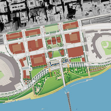
When the stretch of highway was redesigned a decade ago, the better design allowed for several acres of space to be reclaimed for uses that are more productive than a highway. The National Underground Railroad Freedom Center was located on land that was once a highway, as are portions of The Banks development which is currently under construction. Plans for the second phase of The Banks also will make use of the reclaimed land from the redesign. The Banks, bookended by our major league stadia and highlighted by the Freedom Center, is a development project that will fundamentally transform this city’s urban core. It was only made possible through redesigning the stretch of highway and reclaiming under-utilized land on Cincinnati’s urban riverfront.

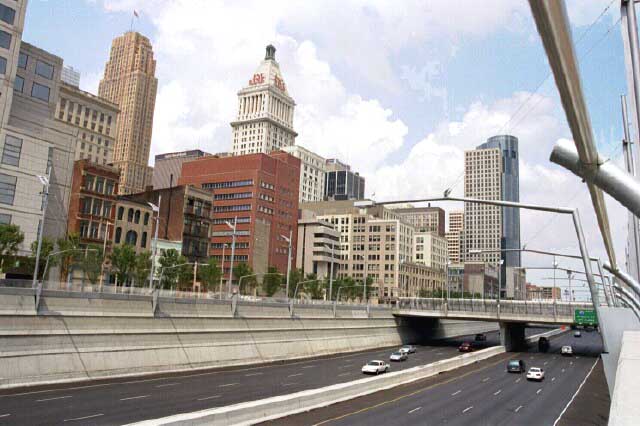
When the Federal government chose to build I-71 through downtown Cincinnati, they chose to do so in an area that already had a major roadway on it. As a result, local authorities were allowed to maintain the rights to the space directly above the federal highway. Generally, when the Federal government builds highways, they maintain the air rights so that they can better control the factors that impact the highway’s utility. In this case, Cincinnati’s ability to maintain control over these rights ensures that the area can be used to its maximum local utility.

To maximize the utility of the space, officials could choose to install 600 feet-long caps over the highway. As has been discussed previously in this series, the reconstruction of Fort Washington Way ten years ago included building infrastructure necessary to support such caps. Structurally, these caps could support several feet of dirt, allowing the city to create a fascinating, unique pocket park in the heart of downtown Cincinnati. Nearby residents would benefit greatly from a place to walk their dogs. Having the retail, office, and residential space at the Banks surrounded by green space on the south with the new riverfront park and on the north with a park above the highway could provide a stunning and dramatic space.

However, some view more park space in that location as unnecessary, and that the real estate in that particular location is too valuable to be planted over. As a result, it is likely in the city’s best interest to explore options that would generate tax revenue. According to engineers responsible for the project, the caps could be built in such as way so that developers would not be restricted with the building materials they use. However, as the height of a building increases, so too does the building’s weight. As a result, buildings on the caps would likely be limited to about four stories in height.

With that particular height, the new development would provide an aesthetic feature that would visually link The Banks to the rest of the central business district. When the first phase of The Banks is complete, portions of mixed-use development will rise six stories above Second Street. Directly to the north of this area sits the trench of Fort Washington Way, followed immediately by highrises like the E.W. Scripps Tower and Cincinnati Enquirer Building. Developers could opt for a design on the caps that would have first floor restaurant or retail options, with offices or residents above.

One of the worst features of the old Fort Washington Way that the new design did not completely fix is that the highway bisects downtown from the Ohio River. Capping the highway and building several-story, mixed-use buildings on it would go a long way to rectifying that disconnect. Because of the required space between the current bridges over the highway and the caps, entrances to these buildings would have to be from Second or Third Street. This particular design would allow comfortable transition north and south between the waterfront and downtown, but would also keep pedestrians moving east and west in the city.

A task force of engineers recently convened to study the feasibility of building and installing these caps. Their task not only includes determining the exact structural capabilities, but also projected costs. Armed with this information, city officials and developers could begin discussions shortly. Should the city push for a unique park over the highway? Or would you rather see a the area built with multi-use buildings?
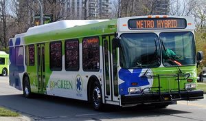
Categories
Business News Transportation

Cincinnati web designer creates ‘Mobilizing Metro’ iPhone app

Aaron Renn recently wrote that It’s Time for America to Get On the Bus. He argues that cities should look at improving the quality of their bus service to eliminate the negative perception and attract more riders. He states that while there’s a “legitimate case for rail” in many cities (including Cincinnati), adding high-quality bus service to the plan can expand the reach of the transit network at a lower cost.

Riders of Cincinnati Metro buses would agree with Renn’s ideas. Metro is often criticized for lacking many of the “amenities” which are now common on other cities’ buses. For example, permanent shelters displaying clear route maps and real-time bus arrival information would make riding an unfamiliar route much easier. Re-loadable fare cards would eliminate the hassle of carrying exact change. Integration with Google Transit would make trip planning easier.

Fortunately, Metro is making progress on some fronts. A new communication system is in the works which will provide riders with real-time bus locations on their smart phones. New articulated buses are providing a much-needed increase in capacity for heavily-traveled routes. Improvements like these are being made as allowed by Metro’s tight budget and other grant sources.  But ideas for innovation at Metro are also coming from outside the organization.

Web designer Ian Monk came up with the idea for an iPhone app called Mobilizing Metro that makes it easier to find routes and nearby destinations.  The app would be able to pinpoint your current location and display what routes pass nearby.

Monk explains, “I distinctly remember a friend of mine, who lives right along the 17/18/19 route, thinking that the buses didn’t run on Sunday because he didn’t know when they came or where they went.”

In order to differentiate the app from similar ones, Monk decided to integrate several types of destinations into the interface.  “It can also filter them so that only destinations within a couple blocks of a chosen bus line show up,” he said.  That makes it easy to find restaurants, bars, post offices, or parks that are completely accessible by public transit, making car-free living much easier.

Monk developed a Flash-based version of the app while he was a Digital Design student at UC.  He recently entered his app into the Cincinnati Innovates competition with hopes to win funding to continue development.  If he receives one of the prizes, which range from $1,000 to $25,000, he hopes to enlist the help of another developer to create iPhone and Android versions of the app.

You can vote for the Mobilizing Metro app at Cincinnati Innovates to help Monk win one of the awards.

With advances like a mobile app, convenient fare cards, and improvements to stops, Metro will continue to attract more riders that have other transit options.  Since Metro will also operate the Cincinnati Streetcar, they have the opportunity to integrate buses and the streetcar into a seamless system.  And although we should continue to get on board with an expanded rail system, we should also make the most of the Metro system we currently have and encourage more Cincinnatians to get on the bus.

Categories
Development News Transportation

Streetscape projects helping transform Fort Thomas business district

The bedroom suburb of Fort Thomas, Kentucky is perhaps best known for its streets of tidy, well-kept houses and its nationally-ranked public schools. Located along a ridge overlooking the Ohio River and downtown Cincinnati, Fort Thomas is an attractive destination for those seeking the relative peace and quiet of a suburban lifestyle, combined with convenient access to downtown Cincinnati along with walkable streets and plenty of historic character.

In recent years, Fort Thomas has become one of several Northern Kentucky cities seeking to enhance its appeal by revitalizing its historic retail district and rediscovering the benefits of pedestrian-scaled, transit-friendly urban development. Fort Thomas’s neighbor to the north, Bellevue, has received recognition for its ongoing historic preservation work, and Bellevue and Covington have both made strides in implementing form-based codes that could ultimately serve as a model for zoning code changes in Cincinnati.

Over the past few years, Fort Thomas has undertaken a number of projects to enhance the city’s role as an attractive community within Cincinnati’s urban core. These projects include new buildings for Highlands Middle School and Woodfill Elementary School, a new amphitheater and bike trails in Tower Park, and the restoration of the city’s iconic 100-foot-tall stone water tower at the entrance to Tower Park. Perhaps most visibly, though, the city of Fort Thomas has recently completed major streetscaping improvements to its primary business district centered around the intersection of Highland and Fort Thomas Avenues and its secondary business district — the so-called Midway district — located adjacent to the site of the former Army post.

Aspects of the two streetscaping projects included burying overhead utility lines, the reconstruction of sidewalks and crosswalks to include brick accents and other decorative elements, the addition of street trees and thoughtful landscaping, installation of pedestrian-scaled light fixtures and signage, as well as the introduction of benches and other outdoor seating. The first phase to be completed was the primary downtown district at Highland Avenue and Fort Thomas Avenue.

Now complete for a couple of years, the trees and plantings in downtown Fort Thomas have begun to nicely mature. Of particular interest is the focus on the former Green Line streetcar, which provided transit access to the Army post and served as a catalyst for much of the subsequent development in the city from the 1890’s through the 1950’s. Fort Thomas is the classic “streetcar suburb”, and today’s TANK bus route through town still carries the Green Line’s old #11 route number.

Following the completion of streetscaping improvements to the downtown district of Fort Thomas, the second phase involved similar improvements to the so-called Midway district, a secondary business district on South Fort Thomas Avenue that grew up adjacent to the former Army post and was named after the carnival midway at the 1893 World Columbian Exposition in Chicago. The site of the Army post — originally built to replace the flood-prone Newport Barracks — is now home to Tower Park, a large Veterans Administration nursing home, and an Army reserve center.

The streetscaping improvements recently completed in the Midway district are similar in nature to those performed in downtown Fort Thomas. Included in the Midway improvements were the reconfiguration of the River Road intersection, which now provides a small civic space that can be used for outdoor concerts or a farmer’s market, and the addition of sidewalk seating for neighborhood establishments such as the Olde Fort Pub and the Midway Cafe.

There are still a number of vacant storefronts in the Midway district, but it is hoped that the now-completed streetscaping improvements along with other measures, such as the restoration of long-vacant officers’ housing nearby and marketing efforts by the newly-formed Renaissance District, will see the addition of new retail tenants to the Midway district.

Categories
Development News Politics Transportation

Reconstructed Fort Washington Way generating variety of societal advances

Each Wednesday in July, UrbanCincy is highlighting Fort Washington Way (FWW), the I-71/US-50 trench bisecting the Cincinnati riverfront from its downtown.  Part one of the series discussed what the area looked like prior to reconstruction a decade ago, and how that reconstruction made way for the development along Cincinnati’s central riverfront.  Last week’s article discussed some of the unseen assets included in the project that continue to benefit Cincinnatians in a variety of ways today.  This week’s piece will highlight even more of the unique features that the 1.25 mile-long highway boasts.

In addition to the combined sewer overflow fix along Cincinnati’s central riverfront through added containment capacity, engineers also increased the capacity for municipal water under Third Street.  This led to an opportunity for the City of Cincinnati to share its high-quality water supply with communities in Northern Kentucky through a new tunnel built underneath the Ohio River.  Those in Kentucky benefit by receiving clean water, and the City of Cincinnati benefits from an increased revenue stream.

On the southern side of the FWW trench is a wall that supports Second Street and conceals the Riverfront Transit Center, but it also serves as the primary flood protection for downtown Cincinnati.  Cincinnati choice to build its flood protection into its everyday infrastructure maximizes utility while also conserving urban space.  Since this wall was engineered to lift Second Street above the floodplain, it effectively extended the street grid south while also maintaining safety.

The benefits discussed so far were not accomplished in isolation.  In fact, the reconstruction project was helped paid for by entities in the state of Kentucky including the Transit Authority of Northern Kentucky (TANK) who saw better connections with Cincinnati as an economic gain.  The project fixed the entanglement of on- and off-ramps to the bridges over the Ohio River, and has led to a better transfer of people and goods across the state line.

The fact that the Cincinnati area calls so many large and lucrative companies home demonstrates that the city once had the ability to draw major economic players to the region.  The fact that they have stayed demonstrates that the area has done well to keep up with changing business, technological, and infrastructure demands.  One such example of keeping up with changing times can be found buried under Third Street, behind the northern wall of Fort Washington Way, where engineers included the capacity for a bundle of fiber optic cables, approximately three feet in diameter, spanning the length of the roadway.

This dark fiber has the capability to be activated and connected with a larger fiber optic network when needed, ensuring that downtown Cincinnati has the ability to stay at the cutting edge of technology.  Possible uses include connecting large-scale data centers to the Internet backbone, or providing high-speed fiber-to-the-home Internet access for Cincinnatians, such as Cincinnati Bell’s FiOptics or Google’s Fiber for Communities.

Next Wednesday’s article will conclude the series, and look to the future of the area.  What can be done with the space over the FWW trench in terms of the capping?  How will future development be impacted?  And, ultimately, will the reconstruction of Fort Washington Way reestablish the strong ties that once existed between Cincinnati and its riverfront?