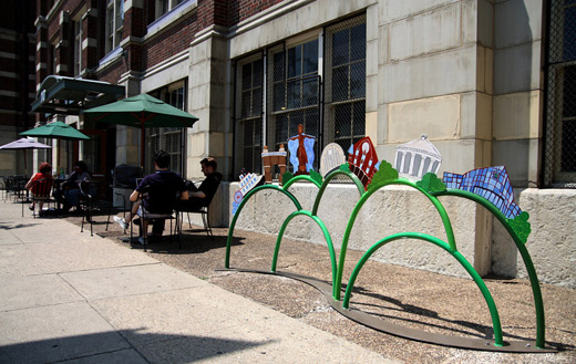
After installing the first Queen City Art Rack in May 2010, ArtWorks is in the process of securing sponsors for the remaining 14 artist-designed bike racks they hope to have installed around Cincinnati by May 2011 to coincide with National Bike Month and ArtWorks’ 15th Anniversary.
ArtWorks executive director Tamara Harkavy said that the non-profit organization has now secured enough sponsors to fund six of those remaining bike racks which cost approximately $7,500 each. The additional money came through sponsorships by Kroger, the Duke Energy Convention Center, Truepoint Financial, Pantene, and Clairol.
The organization plans to install these recently funded bike racks in Northside, Price Hill and Hyde Park Kroger stores, and two locations in downtown Cincinnati. All of the rack locations are being determined based on the needs identified in the city-wide Bicycle Master Plan.
“We are excited about the early support of the Queen City Art Racks program,” said Harkavy. “We have at least nine more funding opportunities along with a number of creative proposals from artists, and we are now looking to close the funding phase and move to the creation phase of the project.”
Project officials at ArtWorks say that the designs for these bike racks will not be developed until December 2010 when they have finalized all fund raising efforts with potential sponsors.
In May, the first Queen City Art Rack was celebrated outside of Coffee Emporium in Over-the-Rhine where it was installed. Named Tours de Cincy, the first rack was designed by Pam Kravetz, Carla Lamb, and Karen Sanders. It was fabricated by Cincinnati-based Vulkane Industrial Arts, and sponsored by the NLT Foundation.
Those interested in sponsoring one of the additional nine racks needing funding can contact Michael Stout at ArtWorks by phone at (513) 333-0388 or email at Michael@ArtWorksCincinnati.org. All sponsorships must be submitted by Thursday, September 30.
The Eastern Corridor project, a multi-modal highway and commuter rail plan for eastern Hamilton County, is back in the news. Two weeks ago Cincinnati City Council voted against endorsing a TIGER II grant application seeking funds for the plan’s 17-mile commuter rail component.
The local media predictably turned this event into another city-county dispute, and insinuated that the TIGER II grant might alone fund construction of the entire Milford commuter rail line, which in 2003 was estimated to cost $420 million. There is no possibility of this happening, as Milford commuter rail would need to be awarded approximately two-thirds of the entire $600 million sum to be dispersed nationwide by the TIGER II program.
The media also ignored the Eastern Corridor plan’s central feature – four miles of the Milford commuter rail line is planned to be built parallel to a new $500 million U.S. 32 expressway between Red Bank Road and a point east of Newtown. The 1990’s cost estimate for Milford commuter rail included the savings associated with building a combined highway and rail project, including a new shared eight-lane bridge over the Little Miami River. The cost of building the commuter line first without provision for the future highway has not been studied.
The Oasis Line
Between downtown Cincinnati and the proposed eight-lane bridge over the Little Miami River, the Milford commuter rail is planned to operate on an eight-mile stretch of track paralleling the Ohio River known as the “Oasis Line.” In the late 1980’s the L&N Bridge (now the Purple People Bridge) was closed to freight rail traffic, and thus ended the operation of large trains along the Oasis Line. Since that time, traffic has been limited to a handful of freight cars per week, and the Cincinnati Dinner Train on weekends.
At first glance it would appear that implementation of commuter rail service on the Oasis Line should require nothing more than the purchase of commuter trains and the construction of a connection between the end of active tracks and the Riverfront Transit Center. Unfortunately, the poor condition of the existing track limits traffic to a maximum twelve miles per hour, meaning all eight miles between the Montgomery Inn Boathouse and Red Bank Road must be rebuilt. It is also probable that the Riverfront Transit Center connection must be built at least partially through Bicentennial Commons at Sawyer Point. All of this new track must be heavy freight railroad track, not the smaller and less expensive track used by light rail trains and modern streetcars.
Even after this needed investment in new track, grade crossings will remain at a half-dozen locations along Riverside Drive and in Columbia Tusculum, where perfunctory horn blasts will disturb those residing in new condos along Riverside Drive, longtime residents atop Mt. Adams and East Walnut Hills, and will surely be audible across the river in Bellevue and Dayton.
Poor Station Locations
Residents of Riverside Drive will be able to hear the Milford commuter rail trains, but most will not live within easy walking distance of the line’s stations. Of five stations proposed along the Oasis Line, only one, Delta Avenue in historic Columbia Tusculum, can be considered auspicious. By contrast, little existing ridership or future development exists around either the proposed Theodore Berry Park or the Cincinnati Waterworks (downhill from Torrence Parkway) stations. Ridership at the proposed Lunken Airport station will be minimal, and the Beechmont Avenue station will primarily serve as a bus transfer point.
On top of this minimal ridership, Riverside Drive is already served by Metro’s #28 bus. If Milford commuter rail is built, this bus will still have to operate due to the infrequent service and long distances between stations along the Oasis Line. It is also likely that Metro’s #28X, which serves Mariemont and Terrace Park en route to Milford, will have to continue operations as well.
An alternative proposal that called for streetcar or light rail service between downtown and Lunken Airport could eliminate the need for the #28 bus route, thus freeing up resources for bus service elsewhere. In this scenario significant savings would be achieved due to the considerably lower track costs for streetcars and light rail when compared to the freight railroad track currently proposed for the Milford commuter rail. Additionally, the vehicles are much quieter because they are electrically powered, labor costs are halved because they require just one driver, and more stops could be placed at much closer intervals.
High Operations Costs
No funding source has been identified to cover the outrageous annual operating costs for Milford commuter rail. In 2004 its annual operations were estimated to be $18.9 million — a sum similar to the estimated annual operating cost of the proposed 250-mile 3C Corridor passenger rail service between Cincinnati, Columbus, and Cleveland.
The cause of these exorbitant operating costs is an alarming combination of mediocre ridership and high labor costs. A 2002 report projected approximately 6,000 weekday trips (3,000 commuters) along the Oasis Line at full build-out. For comparison, this ridership figure is roughly equivalent to Metro’s most popular bus routes. At the same time, the FTA requires a crew of two onboard all diesel commuter trains that operate on freight tracks, even for the small Diesel Multiple Units (DMUs) planned for the Eastern Corridor, due to safety regulations.
By comparison, the Cincinnati Streetcar as presently planned will cost approximately $128 million to construct, require $3 million per year to operate, and will attract similar or higher daily ridership with 15 fewer route miles of track. Last month, city officials were notified that the Cincinnati Streetcar was awarded a $25 million Urban Circulator grant. If an identical amount were hypothetically awarded to the Eastern Corridor project through TIGER II, it would cover so little of the much more expensive Milford commuter rail that no construction would even be able to take place. Meanwhile, an additional $25 million put towards the Cincinnati Streetcar could extend the line into Avondale or Walnut Hills immediately. This means a potential grant for the Milford commuter rail might sit in the county treasury for a decade or more, or through tricky accounting be integrated into the Eastern Corridor project’s highway funding.
The Wasson Line
An alternative rail route to eastern Hamilton County involves use of the Wasson Line, which joins the Oasis Line near Red Bank Road but travels a very different path between that point and downtown Cincinnati. This route is eight miles – the exact same distance as the Oasis Line – but promises much higher ridership and much lower operational costs.
Since all freight operations ceased on the Wasson Line in 2009, electric light rail vehicles staffed by a single driver can be used at considerable cost savings over diesel commuter trains needed on the Oasis Line. Proposed station locations at Xavier University, Montgomery Road, Edwards Road, and Paxton Avenue each promise higher initial ridership — in 2002 the Wasson Line was estimated to attract 20,000 daily riders, or triple that of Milford commuter rail.
Also different from the Oasis Line, redevelopment potential exists around all of the stations locations along the Wasson Line, but especially the 25-acre parallelogram-shaped parcel recently assembled by Xavier University between its campus and Montgomery Road. The abandoned Wasson Road Railroad bisects this property and converges with the similarly abandoned CL&N railroad at the present edge of Xavier’s campus. The particular junction played a major role in the 2002 MetroMoves regional rail plan due to the convergence of several regional lines on their way into downtown along shared Gilbert Avenue tracks.
The Edward Road station is another location superior to anything on the Oasis Line. It is located within walking distance of Hyde Park Square and the majority of the neighborhood’s population. The station would be placed adjacent to, or across the street from, Rookwood Commons shopping center, and just a three-minute walk from the undeveloped Rookwood Exchange site north of Edmondson Road.
The Wasson Line has decisive cost-benefit advantages over the Oasis Line, but it obviously cannot function without a connection between Xavier University and downtown. After completion of the Cincinnati Streetcar, construction of a light rail connection between these points should be a top priority. This section alone promises the highest per-mile transit ridership in the metro area, and reaching Xavier University allows construction of three light rail branches, on existing railroad right-of-way, as funds permit.
Regional Priorities
It is unclear why construction of the Eastern Corridor project is any kind of priority. Much of the expense will be borne by Hamilton County, but with parts of the highway and rail line traveling over the undevelopable Little Miami River flood plain, the new expressway and perhaps even the rail line will act to encourage sprawl in Clermont County. Even the terminal station for the Milford commuter rail will not be in Milford’s town center, where it would be within walking distance of several hundred residents, but rather two miles away at Milford Parkway, home to Wal-Mart, Target, and chain sports bars.
Anti-rail forces are fond of saying that rail advocates will support anything that runs on rails. But advocates of better public transportation know that funds for rail projects are scarce and must be applied where the best cost-benefit exists. Moreover, the best transit mode must be chosen for each route. In the case of inner-city rail to Cincinnati’s eastern suburbs, diesel commuter rail along the Oasis Line is not the best solution, but rather, light rail service along the Wasson Line is.
Cincinnati has been making bold efforts recently to establish itself a more bicycle friendly city. New bike lanes, sharrows, on-street bicycle parking, bicycle parking development requirements, a bike share program, a bicycle commuter station and a bold new Bicycle Transportation Plan are all helping to change Cincinnati’s bicycling community for the better.
So far, the City’s Department of Transportation & Engineering has made bicycle infrastructure improvements in several city neighborhoods including Clifton, University Heights, O’Bryonville, Walnut Hills and Northside. City officials hope that the new bicycle infrastructure and public policy will double the number of people bicycling regularly for transportation in five years. Many local bicycling advocated believe that some of those future improvements need to start happening now.
“We’re urging the City to immediately begin putting bike lanes and other improvements in place on Riverside Drive, Madison Road and Spring Grove Avenue,” stated Gary Wright, President, Queen City Bike. “Those three streets must be a critical part of any serious bike network in the City, and doing this now will show that this is not a plan that will sit on the shelf.”
Of those three streets Wright mentioned, Madison Road is scheduled to be repaved this year making for a perfect opportunity to install bike lanes at the least possible cost to a major transportation route between eastern neighborhoods like Hyde Park to the center city.
Wright adds that Spring Grove Avenue runs right through the epicenter of Cincinnati’s bike culture in Northside and that additional investment along Riverside Drive could bolster that corridor from the popular recreation route it is now to something much more.
“Adding bike lanes now and making other changes to slow traffic through the East End community will encourage more people to give street riding a try while also doing a lot to enhance the neighborhood,” Wright explained. “Bike lanes along Riverside will not serve as a substitute for completing the Ohio River Trail, but they will also make the Little Miami Trail connection planned for Lunken more accessible to a few more riders right away.”
Following eight months of surveys, open houses and on-the-street focus groups, the City is ready to release a draft of the plan and receive final comments from the public. The release of this plan will take place on Wednesday, May 5 from 6:30pm to 8:30pm at the Clifton Cultural Arts Center (map).
The Bicycle Transportation Plan calls for additional infrastructure improvements, educational and encouragement efforts, and enforcement programs. Those interested in providing feedback may do so by contacting the City with comments online or by calling (513) 591-6000 prior to Friday, May 14.
On Sunday, February 14 Metro is challenging Cincinntians to fill one of the transit authority’s new articulated buses with valuable items that can make a positive impact for those struggling to recover from the devastating earthquake that struck Haiti on January 12.
Metro officials will be collecting non-perishable food items, personal care items, cleaning products, first-aid supplies, bottled water, and summer clothing (new clothing only is requested). Matthew 25: Ministries, a local non-denominational organization working to help the needy, will also be collecting cash and check donations that will be distributed to those in need in Haiti.
‘Have a Heart for Haiti’ will take place at the Hyde Park Kroger (map) from 12pm to 6pm on Valentine’s Day.
Beautiful building on Vine Street just south of the Fourteenth+Vine infill project. This would make for a great office building. I doubt it will sit for long.
View more construction photo updates from Over-the-Rhine here.
Hyde Park: The Residences at 2801 Erie condo building, nice density and modern architecture for Hyde Park
View more construction photo updates of 2801 Erie here.
Avondale: Cincinnati Herald Building on Burnet Avenue, the Herald will occupy the top two floors with the street-level spaces being used for retail and possibly a restaurant.
View more construction photo updates of Burnet Avenue projects here.