Categories
Up To Speed

Is NYC getting it wrong by putting development ahead of infrastructure improvements?

Is NYC getting it wrong by putting development ahead of infrastructure improvements?.

New York City officials are looking to pass new regulations that will allow for taller and more modern buildings throughout east Midtown. The demand for office space in the area is extremely high and city leaders would love to capitalize on it, but others worry that the efforts may be short-sighted given the city’s strained infrastructure. More from the New York Times:

With district improvement bonuses, the City Planning study proposes to double the developable floor area on some sites around Grand Central, allowing enough additional square footage to give us a neighborhood of towering office buildings, some as tall as 1,300 feet or more. (For reference, the Chrysler Building is 1,046 feet to the top of its spire.)

But how will the added workers quartered in these new buildings get from their trains to their desks? The plan says that special assessments and payments in lieu of taxes will guarantee “pedestrian network improvements as development occurs.” There is nothing wrong with privately financed infrastructure improvements. But the study, if I read it correctly, gets it backward: first you put in the infrastructure, then you build the buildings. Look at the example of Grand Central, the private enterprise that spurred all this development in the first place.

Categories
Up To Speed

Inadequate regional transit burdens Infrastructure Grade

 Inadequate regional transit burdens Infrastructure Grade.

Last week the American Society of Civil Engineers released their report card on the state of our nations infrastructure. Earlier,  we broke down the report and analyzed what the numbers mean for Ohio and Cincinnati infrastructure but Next City has reviewed the numbers for rail and mass transit. Even though regional rail infrastructure has improved through Amtrak, local mass transit continues to lag behind with a D grade from the ASCE. The report highlights that even though more people are riding transit, the condition of our nations mass transit infrastructure has a backlog in $78 billion worth of repairs. More from Next City:

Transit that doesn’t fall under Amtrak’s purview fared much worse on the ASCE’s report card, earning a D and therefore pulling down the nation’s overall lousy-to-begin-with G.P.A.

Public transit ridership increased by 34 percent between 1995 and 2011, according to the American Public Transit Association, and the ASCE report states that access to transit across the country has grown by nearly 10 percent. Although transit investment has also increased, “deficient and deteriorating” regional transit systems cost the national economy $90 billion in 2010.

Categories
News Politics Transportation

Ohio Fails to Show Improvement in Latest Infrastructure Report Card

We take for granted that bridges, roads, highways, water treatment facilities and dams will function as expected and take us to where we need to go. But our nation’s aging infrastructure has long been in decline as money is diverted from maintenance to construction of new projects, many times for politicians eager for the photo op of a ribbon cutting event.

Recently, the American Society of Civil Engineers (ASCE) released its latest report on the current state of the nation’s infrastructure. The last such report, issued in 2009, had given the country a rating of D. This year’s report showed the nation’s rating had improved to a D+ grade.

“Our country’s association of civil engineers continues to do the yeoman’s work of sounding the alarm on our country’s infrastructure — the roads, rails and waterways that we depend on to move our goods from place to place and get us where we need to go each day,” James Corless, Director of Transportation For America (T4A), stated in a prepared release.

I-75 Reconstruction
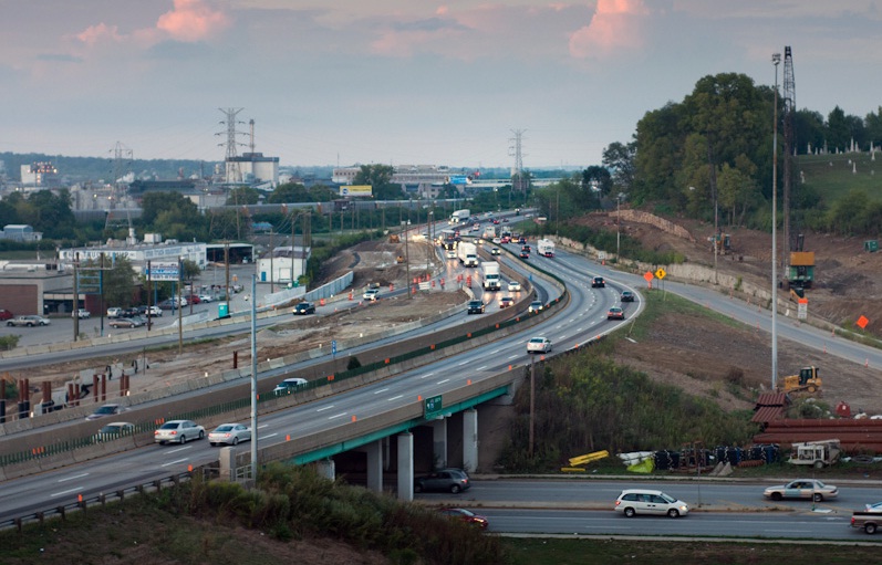
Work on the multi-billion dollar repair and widening of I-75 through Cincinnati proceeds, but the project still has yet to receive the full funding it needs to be completed. Photograph by Jake Mecklenborg for UrbanCincy.

As the nation sifts through a backlog of infrastructure replacement projects, national policy has shifted away from funding such critical infrastructure needs as budgetary concerns linger.

The current transportation bill, Moving Ahead for Progress in the 21st Century (MAP-21), offers no new funding for investments in transportation alternatives to relieve congested corridors or encourage smart solutions to these complex problems.

“It’s a sad reality that little has changed since the last report card in 2009,” Corless continued. “Has anything in Washington changed to drastically improve the condition of our roads, bridges and transit systems in the four years since?”

Without new revenue sources, Corless says, the funding problem is only poised to get worse as revenues continue to decline from the federal gas tax, which has not been raised since 1993. Such a lack of necessary revenues may soon leave the federal government unable to perform basic infrastructure maintenance.

Local Implications?
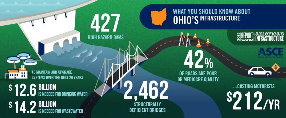
In both 2009 and 2013, the ASCE gave Ohio a C- grade in their infrastructure report card. While the grade places Ohio ahead of the national average, it still translates to 2,462 structurally deficient bridges and approximately 42% of its roadways in “poor” or “mediocre” quality.

While the State of Ohio raised its gas tax in 2006, the extra revenues have not been enough to keep pace with the demand for larger transportation projects like the expansion of I-75 through Cincinnati, the  Brent Spence Bridge project, and the long-planned MLK Interchange project, which all currently stand unfunded or only partially funded.

“Some other states aren’t waiting for billions that are unlikely to come and are thinking about ways to make their dollars do more. Like Massachusetts, where the DOT director issued a goal of tripling the number of trips taken by foot, bike and public transportation — reducing the load on roads and bridges that are among the oldest in the country,” explained Stephen Lee Davis, T4A’s Deputy Communications Director.

Ohio Infrastructure

The City of Cincinnati has been working towards improving some of its worst-rated infrastructure since the last report card was issued in 2009. Since that time, Cincinnati’s Department of Transportation & Engineering (DOTE) has performed a $22 million rehabilitation of the W. Eighth Street Viaduct and is in the midst of a $55 million replacement of the Waldvogel Viaduct which connects the west side with the center city via the Sixth Street Expressway.

Additionally, Cincinnati’s 3,500-foot-long Western Hills Viaduct also is considered structurally deficient. Replacing a span that is nearly twice as long as the longest Ohio River span, and crosses the Midwest’s second busiest rail yard, will be one that is both difficult and costly.

Cincinnati officials say that they are currently studying whether a rehabilitation of the existing 82-year-old, double-decker viaduct or a replacement will be more appropriate.

“That is one of those kind of icons in the Mill Creek Valley that you like to look at,” noted Michael Moore, Cincinnati’s DOTE Director, on The UrbanCincy Podcast. “But we will need to be very cognizant of how we spend the public’s money in making sure we have a good safe mode to get across that area.”

Moore says that the department hopes to wrap up the study on how to fix the Western Hills Viaduct early this spring. Once that is complete, he says that there will be a good idea on how to accomplish that. Where the funding might come for such a large project, however, is still up in the air.

Categories
Business Development News Opinion Transportation

Portland Aims to Replicate Streetcar Success on East Side of Willamette River

Six months ago Portland celebrated the opening of a 3.3-mile extension of their modern streetcar system across the Willamette River.

The $148.3 million Portland Streetcar project represents a significant expansion of the existing six-mile system, and city leaders hope it will find similar success in the Lloyd District, Buckman and Hosford-Abernethy neighborhoods as it has in the Pearl District and Northwest District.

At the time when Portland built its first streetcar leg, the Pearl District was a rundown industrial district in search of new life, and the Northwest District was looking to build on its existing stability.

Pearl District Buckman Neighborhood
Portland’s Pearl District [LEFT] has seen a massive transformation over the past decade, and many hope the streetcar’s recent extension will do the same for the city’s Buckman neighborhood [RIGHT]. Photographs by Randy Simes for UrbanCincy.

The story is not all that different on the east side of the river where the Buckman and Hosford-Abernethy neighborhoods are looking for the streetcar to breathe new life into its underutilized land and lingering industrial users, and the Lloyd District is trying to build on its successes and possibly reinvent itself with a lesser focus on the automobile.

While the streetcar extension is operating daily, the investments are not quite finished. Transportation officials are waiting on an additional six streetcar vehicles to roll off the production line so that service frequencies can be improved for the system’s four million annual riders.

TriMet officials are also overseeing progress on the construction of the new Portland-Milwaukie Bridge which will provide a river crossing for bicycles, pedestrians, streetcars, and light rail from Hosf0rd-Abernethy to the South Waterfront District as part of a the 7.3-mile Portland-Milwaukie Light Rail Project.

The $134 million bridge project is expected to open in September 2015 and buoy both new and existing ridership on the city’s light rail and streetcar systems.

Portland-Milwaukie Light Rail Bridge South Waterfront District
Construction progresses on the Portland-Milwaukie Light Rail Bridge in November 2012 [LEFT], which will connect the Hosford-Abernethy neighborhood with the South Waterfront District [RIGHT]. Photographs by Randy Simes for UrbanCincy.

The verdict is still out on whether or not the new east side streetcar extension will have as big of an impact as it did on the west side of the river next to downtown, but the possibilities are there.

The streetcar’s alignment through Buckman and Hosford-Abernethy heads south along Martin Luther King Boulevard and north a block over on Grand Avenue. To the west of MLK Boulevard is the river with a large collection of warehouses in between. To the east of Grand Avenue is an in-tact neighborhood that has become increasingly popular with young creative types over the past several years.

In between the two streets one will find a collection of aging car dealerships and associated service businesses that date back to the mid-twentieth century.

These large parcels, combined with the large warehouse properties immediately to the west, offer a unique opportunity for large scale redevelopment. Such massive real estate investment might not be plausible without another real estate bubble.

The prospects are there, however, and if Portland can pull off even a fraction of the investment in Buckman as they saw in the Pearl District, then the city will add billions of dollars to its real estate value and create a secondary downtown in the city center for the 2.2 million person region.

Categories
News Transportation

City of Cincinnati to Implement Safety Improvements for Pedestrians

The City of Cincinnati will be working to improve its pedestrian crossings over the coming years in order to align with recently updated state and federal standards.

The Manual of Uniform Traffic Control Devices (MUTCD) was updated in late 2009 and includes new best practices for pedestrian crosswalk designs.

The old standard accepted the typical parallel lines seen throughout most of the city today, but the new MUTCD calls for what traffic engineers call “continental” crosswalk markings, which feature two-foot-wide yellow or white stripes. The new MUTCD also calls for the implementation of countdown pedestrian signals where the pedestrian change interval is greater than seven seconds.

Traditional Intersection Design at Seventh & Walnut
The intersection of Seventh and Walnut Streets downtown represents both the old standard for crosswalk markings and signals. Photograph by Randy Simes for UrbanCincy.

According to Cincinnati’s Department of Transportation & Engineering (DOTE), continental crosswalk markings have not yet been phased in throughout the city, but that as intersections are improved the City is working to upgrade both the pedestrian signals and crosswalk.

“The parallel markings were, at one time, considered “the standard” for crosswalk markings,” Michael Moore, Director of Cincinnati’s DOTE, told UrbanCincy. “However, with the update of the MUTCD in late 2009, best practices established the continental makings as a preferred design.”

The new continental markings are seen as a safety improvement for both pedestrians and drivers as they make crosswalks more visible, thus reducing collisions between automobile drivers and pedestrians.

The new markings, however, do pose some installation and maintenance issues for local governments.

Continental Crossing at Smale Riverfront Park
The mid-block crossing, connecting Smale Riverfront Park with The Banks, on Mehring Way features a continental crossing design. Photograph by Randy Simes for UrbanCincy.

“We place most of our markings with thermoplastic because of its durability and reflectivity; however when wet, it can be slippery,” Moore explained. “And because the continental markings require more paint or thermoplastic, they cost more to install, and more to maintain since more of the stripe is in-line with the traffic flow.”

In order to help save taxpayer dollars, Moore says that the City studies where exactly to place the markings so that they avoid the most common path of wheel travel.

Crosswalk signals with countdown timers, meanwhile, have become more popular throughout the United States since cities like Washington D.C. began testing them years ago. Locally, both Covington, KY and Newport, KY have had these timers in use in their downtowns for years.

In addition to these new countdown timers at crosswalks, the time signals allow for pedestrians to cross the street may also soon be changing. Cincinnati officials say they will be adjusting pedestrian signals to accommodate the region’s aging population.

“Where the previous timing assumed pedestrians travel approximately 4 feet per second, the new manual reduces that to 3.5 feet per second,” noted Moore. “It doesn’t sound like a lot, think about the number of large intersections we have.”

There is no set timing on these upgrades, but Cincinnati officials say that more and more crossing signals will be changed out over the coming years, and that crosswalk markings will change as intersection upgrades are performed. Cincinnatians can already see the new continental markings in place a non-signalized, mid-block crossings.