Categories
Business Development News

Phase two of The Banks set to begin construction in early 2013

[This story was originally published in the October 5, 2012 print edition of the Cincinnati Business Courier. You can read that story online for additional comments and discussion about the forthcoming phase of work at The Banks – Randy.]

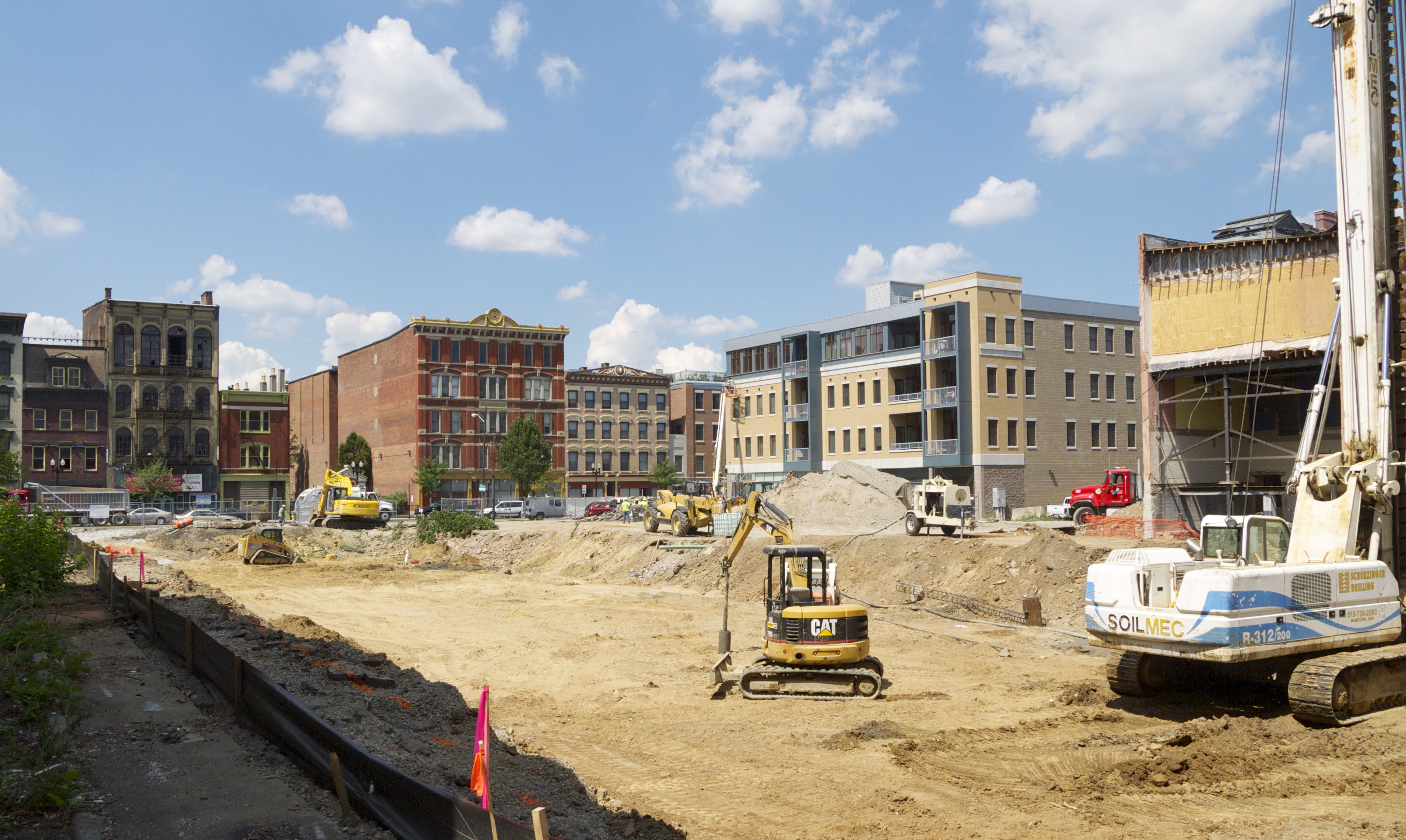
Developers of The Banks hope to break ground in early 2013 on the next major phase of construction work at the $600 million development.

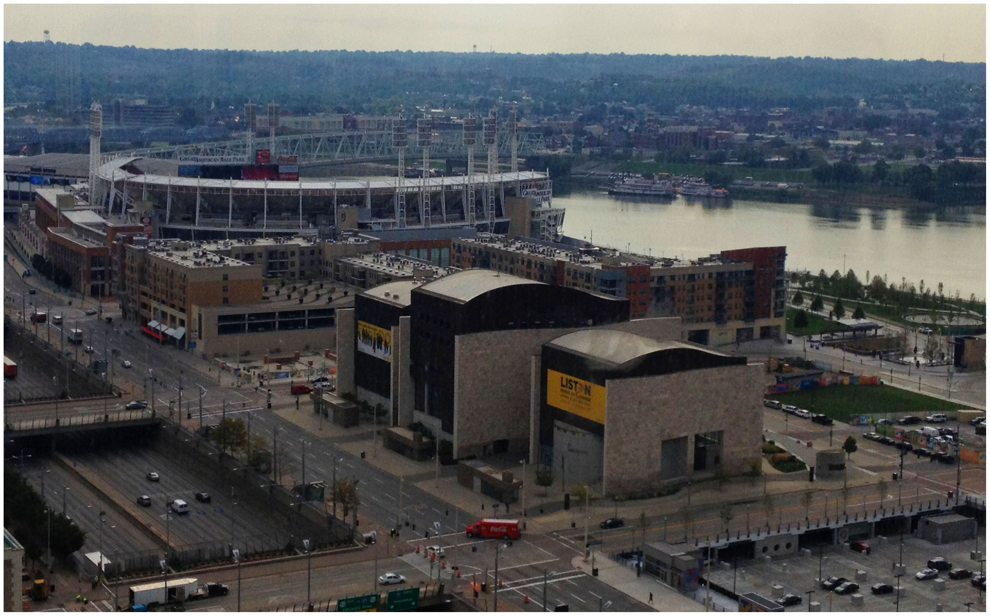
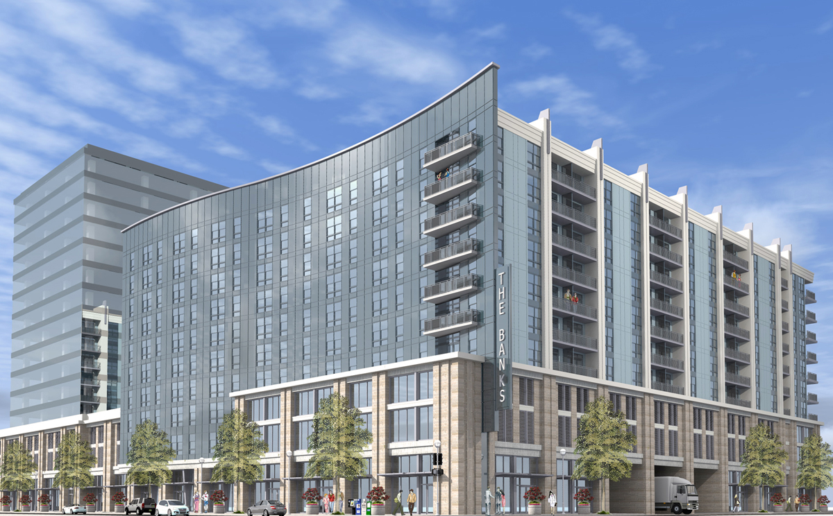
Following the success of the $91 million Phase 1, newly revealed designs for the riverfront development call for an additional 300 apartment units, more than 60,000 square feet of street-level retail and more than 400 parking spaces at the block southeast of Race and Second streets, said Libby Korosec, spokeswoman for The Banks development team. The structure is one building, but appears to be two, sitting on a three-story foundation.


The next major phase of construction at The Banks is planned to get started in early 2013. Rendering provided.

The Banks development team has until now been quiet about the design for the second major phase. According to principals at the Preston Design Partnership, an Atlanta firm selected by Carter for Phase 2 design work, the designs have received approval from Cincinnati’s Urban Design Review Board after two “productive” meetings over the course of the summer.

“The review board liked the concept, but they thought we had watered down the idea across all of the elevations in terms of its 3D massing,” said Edsel Arnold, senior design principal with Preston Design. “They also wanted us to look at how the structure appeared within the city skyline view, and were worried that some of the original color on the building would look too cold in front of the city skyline.”

Taking the board’s comments into consideration, Arnold said that the team went back to the drawing board to better match color schemes with the surrounding cityscape and build upon their design concept.

Building reflects city’s grid, riverfront
The end results include more gray and light blue colors to match existing buildings in the Central Business District. With a strong emphasis placed by the UDRB on integrating the designs of Phase 2 with the city skyline in mind, the colors were considered a critical element.

Arnold said the three-story base of the building will include brick to match that of other nearby structures and also offer some variation in the building’s use of materials. The two structures that will rise from the base will largely be made up of grayish-blue glass and vertical white columns.

Preston’s concept was influenced by the unique convergence of Cincinnati’s orthogonal grid street system with the organic curves of the central waterfront, Arnold said. It was this design concept that led to an eye-catching curved glass façade on the north side of the 10-story structure.

“Being from Atlanta, we were struck by the way that the city comes out of the plain and comes out to the water’s edge,” Arnold explained. “We decided it would be fun to play a strong curve along one of the walls, and let the other three sides play up more of the grid system of the city.”

To that end, the remaining three walls will be flat, as is true with most buildings in downtown Cincinnati. And a popular design element carried over from Phase One, balconies, will be incorporated onto the building’s western and southern façades to take advantage of city and river views.

From here, the design team will return to the design review board for final approval later this fall.

“We don’t have a schedule set for Phase 2 yet, but we are pleased with the progress being made on the development overall,” Korosec said.

Developer still seeking hotel, office deals
Project officials also say that they continue to work on negotiations for a potential operator for a hotel tower and tenants for an office tower planned to be built within the footprint of Phase 1 work. Townhouses planned to front along the Schmidlapp Event Lawn are also pending financing.

Once complete, the $2.5 billion public-private development partnership will transform Cincinnati’s central riverfront with 3,000 new residents, 1 million square feet of commercial space and 300,000 square feet of hotel space. The first major phase of construction work was completed in 2011 and has been considered a major success by city officials and the development team, with 100 percent of its apartments leased and about 92 percent of its 96,000 square feet of retail space occupied.

Those who would like to access more premium content from the Cincinnati Business Courier can take advantage of UrbanCincy‘s exclusive subscriber discount. The discount allows readers to get full access to all of the Business Courier‘s premium content for 52 weeks at the cost of just $49.

Categories
Development News Transportation

Cincinnati officials are looking for design ideas as they work to cap urban highway

Billions of dollars of public and private investment has transformed Cincinnati’s central riverfront over the past decade. What was once a flood-prone industrial center turned unusable waterfront property, is now home to a new park, neighborhood, museums, and professional sports venues.

The investments made to date have been so successful, in fact, that they are creating spinoff investment in the Central Business District. A remaining hurdle, however, is the crossing of Third Street, Fort Washington Way (FWW), and Second Street.

The nearly 300-foot span of roadways was significantly reduced in width when Fort Washington Way was reconstructed in 2001, but the span remains a visual barrier for many of those in the Central Business District or at The Banks.

Cincinnati officials are looking to build off of recent success by capping Fort Washington Way. Photograph by Randy A. Simes for UrbanCincy.

The problem was expected by city officials, in the 1990s, during original planning efforts for the central riverfront’s transformation. As a result, city leaders worked to raise $10 million to construct pile foundations that could one day support a cap over the interstate highway running beneath street level on FWW.

The pile foundations are capable of extending 600 feet over the highway roughly between Elm Street and Main Street. According to engineers who worked on FWW’s reconstruction, the caps could support the weight required for a park, or built structures depending on height and building materials.

No specific development plan for the caps has been developed however, and now the city is launching a design competition called Connect the Blocks to establish a vision for space.

“The Banks is well underway, downtown is growing, and now we must begin thinking about what we as a community want to see over Fort Washington Way to connect downtown and the riverfront,” City Manager Milton Dohoney stated in a prepared release. “We must first have a common vision of what we want, then we can establish the roadmap to get there.”

The national competition is calling on architectural, engineering and design professionals to create and submit concepts and cost estimates for the caps that are to be built over FWW. According to city officials, three to five finalists will be selected and awarded stipends to further refine their designs.

St. Louis has dealt with similar issues as it has tried to bridge the divide created by I-70 between downtown and the Gateway Arch grounds. While I-70 will not be capped entirely, a one block portion is envisioned to connect Jefferson National Expansion Memorial with Kiener Plaza in the CityArchRiver 2015 plan.

In Ohio, the only similar example of such a project exists in Columbus where a $7.8 million cap was constructed over I-670 along N. High Street. It includes approximately 25,000 square feet of street-level retail and connects Columbus’ downtown with its Short North district.

The City of Cincinnati held the first of two public meetings, on the design competition, last Wednesday in Madisonville. The second meeting is scheduled to take place on Tuesday, October 9 at 6pm at the Main Public Library (map). The public is also invited to weigh in on the process by participating in an online survey going on now, and officials also say that the public will be invited back to view the finalists’ designs once they are selected.

Full details about how to participate in the eight-month design competition can be found on the project’s website. The implementation of any winning design, officials say, will be dependent upon the availability of funding.

Categories
Development News Transportation

City to move forward with utility relocation for streetcar project

Cincinnati leaders announced a major step today in moving forward the construction schedule of the Cincinnati Streetcar, after a recent memo from City Manager Milton Dohoney conceded that the project had been delayed to summer 2015.

According to the August 28 memo, city officials had not been able to resolve negotiations with Duke Energy over utility replacement costs. A new legislative package, which is set to go before the Budget & Finance Committee on September 24, seeks to sidestep the negotiations and start the next phase of utility relocation work on the streetcar.

“It is not feasible to sit idle awaiting an outcome,” City Manager Dohoney explained in a prepared statement.

The first piece of legislation establishes a $15 million account from which the City will advance the work for the Duke Energy utilities until the City and the energy company can fully address who must pay for the relocation of electrical and gas lines under city streets. This figure is what was disclosed to the City by Duke Energy as the cost of utility relocation and design work.

While both parties reached an agreement to the three feet separation from the tracks, as is used in other cities, the ongoing issue is over who is responsible to pay the cost of utility relocation. The City has maintained that the streetcar is a transportation improvement project and that Duke Energy is responsible for utility relocation costs.

City officials broke ground on the streetcar project earlier this year. Photograph by 5chw4r7z.

Funding for the account will come from part of the recent $37 million sale of land adjacent to the former Blue Ash Airport. As recently reported by UrbanCincy, the City of Cincinnati sold most of the former airport land to the City of Blue Ash for a new park but retained approximately 100 acres.

Once an agreement is reached in the dispute, the City expects that the $15 million will be recovered and become available for other investments throughout the city. According to City officials, by fronting the cost of utility relocation work, it will be able to avoid potential legal disputes and any further delay or cost increases.

The second piece of legislation changes the funding source for repayment of $14 million of the $25 million in notes issued as part of the original streetcar project proposal. According to the City’s finance department, the funding shift does not add cost to the project but instead shifts the funding temporarily from the Downtown South TIF District to a fund created in 1995 that collects service payments from Westin/Star, Hyatt and Saks. Half of these funds are reserved for housing projects throughout the city and the other half is currently unallocated. Once the City revises the districts revenue funding it will be able to assess how much debt it can borrow against the revised Downtown South TIF District.

The final item for consideration is a right-of-way ordinance confirming and clarifying the City’s existing historic rights for utility relocation. This legislation, also enacted in other large Ohio cities, unequivocally asserts a municipality’s authority to require a utility in the public right-of-way to relocate its facilities – at the utility’s sole cost – when required in order to accommodate construction of a public improvement.

City officials have disclosed to UrbanCincy that they are confident an agreement with Duke Energy will be reached. In the meantime, this procedure will allow crucial construction of the streetcar to advance, including track construction work and ordering of the streetcar vehicles.

“Cincinnati is still growing and the streetcar project is still a part of that,” City Spokesperson Meg Oldberding told UrbanCincy. “This should be a good signal that the streetcar is moving forward.”

The Budget & Finance Committee meeting will be held on Monday September 24 at 10:30am in Room 300, in City Council Chambers at City Hall.

UPDATE: The two items passed through City Council’s Budget & Finance Committee 6-3 with P.G. Sittenfeld (D), Charlie Winburn (R), and Christopher Smitherman (I) voting in opposition. The Budget & Finance Committee is made up of the full nine-member City Council which is expected to pass the measures by the same margin at their regular meeting this Wednesday.

Categories
Business Development News

EXCLUSIVE: 3CDC Commits to Shared Parking Plan for Over-the-Rhine

Just four days after publishing an exclusive story which uncovered that the amount of parking provided at the Mercer Commons development exceeded city mandates and added approximately $4.25 million to the project cost, officials from the Cincinnati Center City Development Corporation (3CDC) contacted UrbanCincy to offer more information surrounding the Mercer Commons Garage.

Many commentors on our previous story defended 3CDC and claimed that such parking provisions at the Mercer Commons Garage would allow for less parking at future developments. Adam Gelter, 3CDC’s Vice President of Development, echoed these thoughts and stated that future developments would in fact utilize the parking garage, although only some of those projects have been financed, and even fewer approved for zoning variances by the City of Cincinnati.


Work at the Mercer Commons construction site in August 2012. Photograph by Travis Estell for UrbanCincy.

In particular, Gelter, stated that the 359-space Mercer Commons Garage allows for one parking space at every unit within that development, but that those living at Mercer Commons would not be required to purchase a space. This, 3CDC asserts, will allow for the parking garage to be utilized more efficiently.

The debate becomes even more nuanced when the status of Over-the-Rhine’s historic district designation and ongoing comeback as a desirable neighborhood are taken into account.

“In a place like OTR, which is coming back strong but still has a long way to go, I think we want the neighborhood to be as welcoming as possible to visitors and to satisfy any concerns they may have about safety,” responded Kaid Benfield, director of Sustainable Communities for the Natural Resources Defense Council (NRDC). “The key for a historic district, I think, is to keep the parking from occupying so much space that it interferes with the historic character of the neighborhood.”

In addition to the Mercer Commons development, 3CDC officials say that they are planning a 30- to 40-unit residential development at the parking lot where Smitty’s once stood. Furthermore, 3CDC expects the office tenant at the Paint Building to require 25 spaces, another 15 to 20 spaces at the former Boss Cox building, and potentially 50 spaces for office users at Cintrifuse. Furthermore, project officials say surrounding restaurants could use additional parking for their customers.

“Of the seven upcoming developments, only one has its own parking, and the rest have spaces assigned at either the Mercer Garage or Washington Park Garage,” Gelter explained. “We give condo owners a right to buy a monthly space, and we refuse to assign spaces so that we can turn the spaces as much as possible.”

To that end, Gelter explained that only six parking spaces at the Fountain Square Garage are reserved at any given time for its 250 monthly pass holders.


Rendering of the $53.5 million Mercer Commons development in historic Over-the-Rhine. Image provided.

The goal would be to reduce the number of surface parking lots needed to serve new developments throughout historic Over-the-Rhine, but 3CDC officials say that what has already been put in place will probably be difficult to undo.

“We would love to get rid of and develop the Twelfth and Vine parking lot, and we would like to stop building surface parking lots to the extent that is possible,” Gelter told UrbanCincy. “However, parking lots for condo buildings only are going to be very difficult to get rid of, so we don’t want to do that anymore.”

Gelter went on to say that one potential option would be to keep the Gateway Garage open to the public. Just over one year ago Kroger purchased the 950-space parking garage from the City of Cincinnati for $4.5 million, and currently experiences low usage rates outside of workday hours.

When it comes down to it, however, it appears as though the status quo for providing parking within the urban core will continue regardless of what policies come out of City Hall.

“Some of our upcoming developments have been approved for no on-site parking, and some have not,” Gelter conceded. “The goal would be to build structured parking to minimize the extent we need to use surface and street parking, but we have to take it on a case-by-case, and block-by-block basis.”

The first phase of construction at Mercer Commons is currently underway, and is expected to be complete by March 2013. Two additional phases of work are planned to follow.

Categories
Development News Politics Transportation

Funding questions loom while reconstruction of I-75 progresses

In the early 2000s the Ohio Department of Transportation (ODOT) formulated plans to rebuild and widen Interstate 75 between the Ohio River and I-275. The overall plan was divided into three project areas: The Brent Spence Bridge, Millcreek Expressway (Downtown north to Paddock Road), and Thru the Valley (Paddock Road north to I-275).

Originally all fifteen miles of work were expected to be completed by 2020, but ODOT’s financial crisis has meant just three of the 17 phases comprising the Millcreek Expressway and Thru the Valley sections have commenced construction. The complex character of the planned reconstruction means some phases must be built before others but little benefit to safety and traffic capacity will be realized until nearly all sections are complete.


September 2012 I-75 reconstruction photographs by Jake Mecklenborg for UrbanCincy.

In short, work currently underway will build retaining walls and build new overpasses for an expanded highway, but the expressway itself cannot be widened in these areas until adjacent phases are completed.  So improvements currently under construction at Mitchell Ave. might be decades old before they are put to full use – or worse, these future phases might never be built.

Thus far, ODOT has only completed the $7.1 million second phase which rebuilt the Monmouth Street overpass in Camp Washington. Originally planned to be built as part of Phase 5 (Hopple Street to Mitchell Avenue), the Monmouth Street Overpass was deemed “shovel-ready” and funded through the American Recovery & Reinvestment Act of 2009.

The $53 million reconstruction of the Mitchell Avenue Interchange (Phase 1) began in 2011. Construction crews are presently demolishing the 57-year-old Mitchell Avenue and Clifton Avenue overpasses and preparing the right-of-way necessary to widen I-75 from six to eight lanes.

ODOT has scheduled a summer 2014 completion for the Mitchell Avenue work.

Modification of the Colerain/Beekman/I-74 Interchange (Phase 3) also commenced in 2012. This $13 million project is also currently taking place, and is also scheduled for completion in 2014.


An ODOT official explains what led to the financial troubles of ODOT at a Transportation Review Advisory Council meeting in 2011. Video by Jake Mecklenborg for UrbanCincy.

Yesterday ODOT Director Jerry Wray announced funding for the first phase of the $467 million Thru The Valley project.  Although funding is now programmed for reconstruction of I-75 between Shepard Lane and Glendale-Milford Rd. beginning in 2021, there is still no definite timetable for the Thru the Valley’s other 7 phases.

These delays in work on I-75 in Cincinnati illustrate the central problems with state and federal gasoline taxes: the taxes are not automatically adjusted with inflation, causing revenues to drift downward over time, and proceeds fall when high gas prices motivate people to drive less. Until either or both gasoline taxes are raised, or ODOT identifies new funding sources, reconstruction and widening of I-75 will proceed at a glacial rate, and drivers will realize little benefit from completed early phases.