Categories
Arts & Entertainment News Transportation

2012 MidPoint Music Festival bicycle parking overview

The City of Cincinnati has partnered with the MidPoint Music Festival (MPMF), for the second consecutive year, to offer expanded bicycle parking options.

This year’s MPMF is shaping up to be the biggest yet, and as a result, city officials say that they will convert nine on-street automobile parking spaces into bicycle-only parking stalls. Each stall will include a lockable bike corral that can accommodate up to 12 bicycles comfortably.

The spaces will be temporary in nature, and will be removed at the end of the three-day music festival which begins today.

“We want to encourage festival goers to try going carless this year,” explained Cincinnati’s Department of Transportation & Engineering (DOTE) director, Michael Moore. “With all of the venues located in such a compact area in OTR and Downtown, this is a great opportunity to experience how easy it is to get around town on a bicycle.”

The converted spaces will compliment an existing permanent collection of structured bicycle parking throughout the Central Business District and historic Over-the-Rhine. Those hoping to take advantage of the bicycle parking options during this year’s MPMF can refer to the following map for guidance.

Categories
Arts & Entertainment News Transportation

Cincinnatians transform dozens of parking spaces into temporary parks

For the fifth straight year Cincinnati has participated in the international advocacy effort known as Park(ing) Day. The event, which takes place annually on the fourth Friday in September, aims to draw attention to how much public space is dedicated to automobile parking in our communities. Community organizers do this by taking over on-street parking spaces in cities throughout the world, and turning them into temporary spaces that are more usable by the general public.

In past years Cincinnati has seen parking spaces transformed in the Central Business District, Over-the-Rhine and Clifton Heights. The Central Business District has served as the most hostile location for the activists with several being confronted by business owners and police in past years. Over-the-Rhine, on the contrary, has become the defacto home for the movement, and in 2012 saw more than a dozen spaces converted in the historic neighborhood.


Temporary park/cafe space on Main Street outside of Park+Vine. Photograph by Travis Estell for UrbanCincy.

Cincinnati’s 2012 campaign took on a much different flavor than in past years. Instead of a small collection of grassroots spaces, Merchants of Main Street partnered with Art on the Streets to create temporary art in spaces up and down Main Street between Central Parkway and Liberty Street. The effort included ballet dancers, painters, art installations, and a violinist between 5pm and 7pm.

While the active art spaces took place outside of core business hours, when many Park(ing) Day spaces are set up due to parking demand, organizers were able to dramatically increase the number of converted spaces, and the number of people involved.

Also showcased during this year’s Park(ing) Day was a preview version of what will become Cincinnati’s first parklet – a mini-park built on top of an on-street parking space – in front of Tucker’s on Vine Street.

The following slideshow highlights many of the parking spaces transformed into other uses during Cincinnati’s 2012 Park(ing) Day. All photographs were taken by Travis Estell for UrbanCincy.

Categories
Development News Politics Transportation

Funding questions loom while reconstruction of I-75 progresses

In the early 2000s the Ohio Department of Transportation (ODOT) formulated plans to rebuild and widen Interstate 75 between the Ohio River and I-275. The overall plan was divided into three project areas: The Brent Spence Bridge, Millcreek Expressway (Downtown north to Paddock Road), and Thru the Valley (Paddock Road north to I-275).

Originally all fifteen miles of work were expected to be completed by 2020, but ODOT’s financial crisis has meant just three of the 17 phases comprising the Millcreek Expressway and Thru the Valley sections have commenced construction. The complex character of the planned reconstruction means some phases must be built before others but little benefit to safety and traffic capacity will be realized until nearly all sections are complete.


September 2012 I-75 reconstruction photographs by Jake Mecklenborg for UrbanCincy.

In short, work currently underway will build retaining walls and build new overpasses for an expanded highway, but the expressway itself cannot be widened in these areas until adjacent phases are completed.  So improvements currently under construction at Mitchell Ave. might be decades old before they are put to full use – or worse, these future phases might never be built.

Thus far, ODOT has only completed the $7.1 million second phase which rebuilt the Monmouth Street overpass in Camp Washington. Originally planned to be built as part of Phase 5 (Hopple Street to Mitchell Avenue), the Monmouth Street Overpass was deemed “shovel-ready” and funded through the American Recovery & Reinvestment Act of 2009.

The $53 million reconstruction of the Mitchell Avenue Interchange (Phase 1) began in 2011. Construction crews are presently demolishing the 57-year-old Mitchell Avenue and Clifton Avenue overpasses and preparing the right-of-way necessary to widen I-75 from six to eight lanes.

ODOT has scheduled a summer 2014 completion for the Mitchell Avenue work.

Modification of the Colerain/Beekman/I-74 Interchange (Phase 3) also commenced in 2012. This $13 million project is also currently taking place, and is also scheduled for completion in 2014.


An ODOT official explains what led to the financial troubles of ODOT at a Transportation Review Advisory Council meeting in 2011. Video by Jake Mecklenborg for UrbanCincy.

Yesterday ODOT Director Jerry Wray announced funding for the first phase of the $467 million Thru The Valley project.  Although funding is now programmed for reconstruction of I-75 between Shepard Lane and Glendale-Milford Rd. beginning in 2021, there is still no definite timetable for the Thru the Valley’s other 7 phases.

These delays in work on I-75 in Cincinnati illustrate the central problems with state and federal gasoline taxes: the taxes are not automatically adjusted with inflation, causing revenues to drift downward over time, and proceeds fall when high gas prices motivate people to drive less. Until either or both gasoline taxes are raised, or ODOT identifies new funding sources, reconstruction and widening of I-75 will proceed at a glacial rate, and drivers will realize little benefit from completed early phases.

Categories
Arts & Entertainment News Transportation

Prize to be awarded for best idea at improving urban mobility at September’s URBANexchange

Due to the Reds home schedule, we had to adjust our regularly planned meeting time for this month’s URBANexchange at the Moerlein Lager House. Instead of being held on the first Tuesday of the month, we will be holding it on Thursday, September 13 from 5pm to 7:30pm.

This month we will be getting together just as we have been, but to jumpstart the conversation we thought we would give it a transit theme. We hope you come to discuss ideas that could help improve urban mobility.


Attendees enjoy the Moerlein Lager House and conversation at the August 2012 URBANexchange. Photograph by John Yung for UrbanCincy.

All of the ideas submitted will be reviewed by the UrbanCincy team. The person with the winning submission will then have their idea profiled in an UrbanCincy.com feature story. Will we also do a drawing, from the submitted entries, for a free Metro monthly bus pass courtesy of the Southwest Ohio Regional Transit Authority (SORTA).

The themed transit discussion corresponds with the Metropolis & Mobility Seminar taking place at the University of Cincinnati, and we have confirmed that Paul Grether, Metro’s Manager of Rail Services, will be among those in attendance.

Other notable transportation experts are also expected to be confirmed within the coming days, so stay tuned for those announcements as we get closer to the event date.

Those interested in attending are encouraged to stop by the biergarten at the Moerlein Lager House (map) anytime between 5pm and 7:30pm. There is no entry fee, but we do strongly encourage you to support our host establishment by purchasing food or drink while you are there.

Due to scheduled events at the Moerlein Lager House, it is expected to be a bit more crowded than usual. As a result, we recommend that you arrive early so that we can reserve additional space as is necessary.

Categories
Development News Politics Transportation

Plan Cincinnati aims to guide city back towards its urban roots

After a three-year planning process, Cincinnati’s first comprehensive plan in 32 years will be shared with the city’s Planning Commission. The hearing marks a ceremonious occasion for city employees that have worked tirelessly on the plan since Mayor Mark Mallory (D) tasked them to work with the community on putting together an updated plan for the Queen City.

The City of Cincinnati Planning Department will share the 228-page document with the Planning Commission at 6pm today at City Hall (map). From there the document will move on to City Council’s Livable Communities Committee, and then the full City Council for approval where officials do not expect much, if any, pushback from the nine-member elected body. After formal approval from City Council, the document will become Cincinnati’s policy guide for everything from financial to environmental decisions, and beyond.


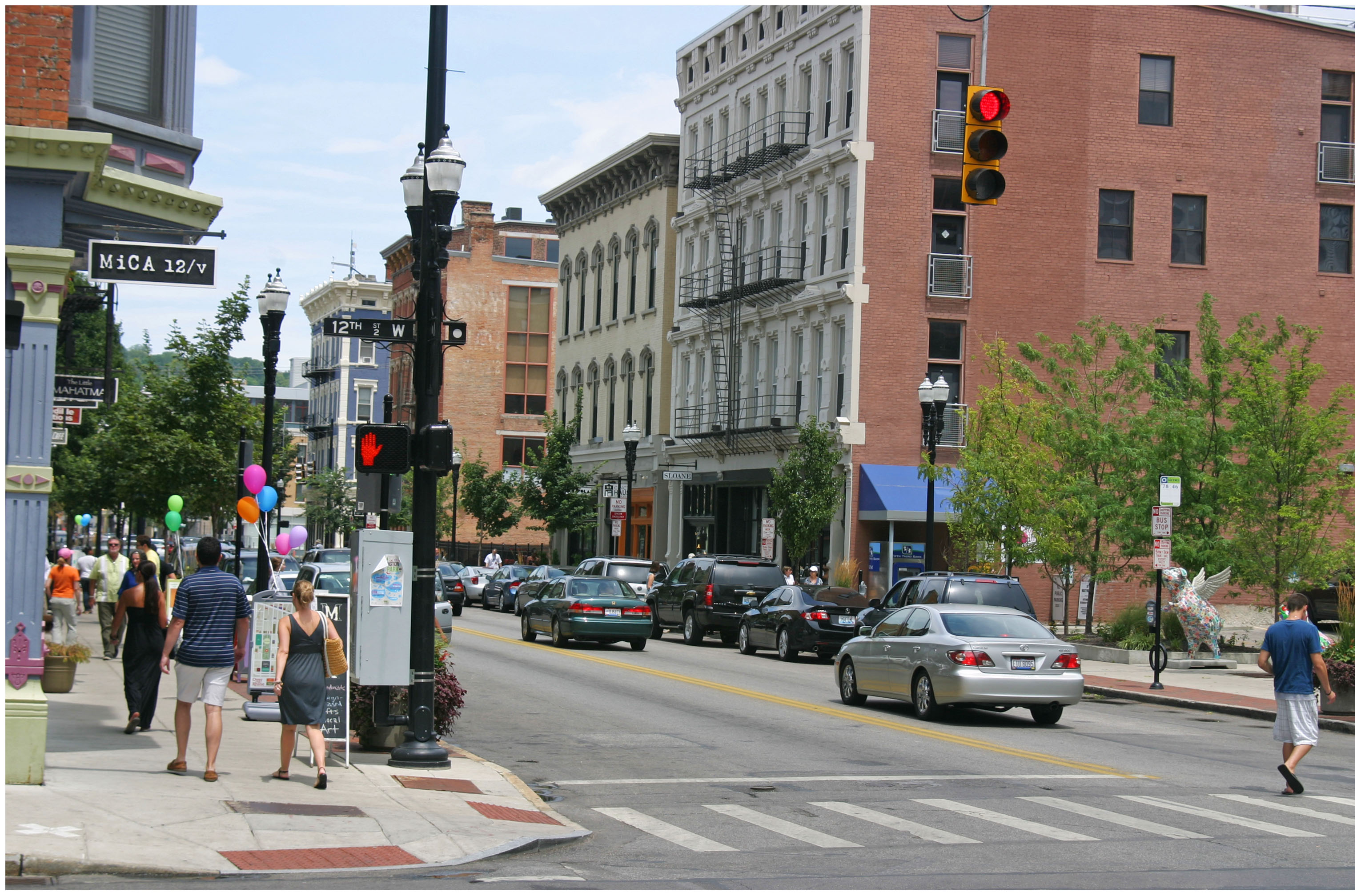
The city’s new comprehensive plan, Plan Cincinnati, places a strong focus on creating and building upon walkable neighborhood centers. Photograph by Randy A. Simes for UrbanCincy.

The tone for the city’s new vision is set early and often throughout the document stating, “The vision for the future of Cincinnati is focused on an unapologetic drive to create and sustain a thriving inclusive urban community, where engaged people and memorable places are paramount, where creativity and innovation thrive, and where local pride and confidence are contagious.”

The focus on a comprehensive urban approach is a bold diversion from Mayor Charlie Luken’s (D) administration which ultimately left the city without a Planning Department after a heated debate over whether to allow Vandercar Holdings to build a suburban-style development at what is now the Center of Cincinnati big-box development.

In the early 2000s, Vandercar had agreed to go along with Cincinnati’s Planning Department and build a mixed-use development on the site. Disagreements over the project led to a change of heart by the development team, and a strong reaction by both Mayor Luken and then City Manager Valerie Lemmie to dismantle the city’s planning department.

The renewed focus on urbanism in the Plan Cincinnati document establishes 11 goals that range from growing the city’s population, to becoming more aggressive with economic development, to developing a culture of health. One of the key goals set out by Plan Cincinnati calls on leadership to build on the city’s existing assets. To that end, the plan identified 40 Neighborhood Centers that should serve as the diverse, walkable centers of activity throughout the city.

Of those 40 nodes, approximately 28 percent are recognized as “urban” neighborhood centers while the remainder are identified as “traditional” neighborhood centers.

       
Plan Cincinnati recognized 40 Neighborhood Centers throughout the city [LEFT], and identified 14 preliminary areas to examine for future investments that could lead to new Neighborhood Centers [RIGHT]. Maps provided.

“Our neighborhoods are structured around centers of activity that contain all of the amenities that we need to go about our daily life,” the Plan Cincinnati document states. “We will focus our development on these centers of activity, and strategically select areas for new growth.”

From there the plan recognizes which of those neighborhood centers are doing a good job at serving as diverse, walkable centers. Seven are seen as well off and simply needing maintenance; 12 are identified as areas that need to evolve and become more walkable, and the remaining 21 are called on to be transformed with large-scale changes such as infill, redevelopment, and public improvements.

“We will permeate our neighborhoods with compact, walkable mixed-use development, bikable streets and trails, and transit of all types (such as bus, light rail, bus rapid transit, light rail transit, streetcar/circulator vehicles, and passenger rail),” declares the Plan Cincinnati document. “The development of a Complete Streets policy and adoption of a form-based code are tools that will help reach this goal.”

A sobering fact, presented within the plan, is that roughly 22 percent of all Cincinnati households have no automobile, while only a percentage of those households have safe and easy access to the jobs, goods and services they need.


Approximately 22% of Cincinnati households do not own a car, and are not within easy access to the goods and services they need. Map provided.

To help solve that issue, city planners hope to build upon the goal of creating a healthy, sustainable community by eliminating food deserts and providing fresh produce within a half-mile, or 15-minute walk or transit ride, from all residential areas.

City planners acknowledge, however, that building upon existing assets will not be enough in order to create the envisioned outcomes identified within PLAN Cincinnati. As a result, the document identifies 14 preliminary opportunities (see second map) for future mixed-use development that can eventually serve as new neighborhood centers where they are currently lacking.

While the visioning document looks to be unapologetic about its urbanist movement, it also looks to firmly establish Cincinnati as the unapologetic leader within the larger region, stating that consolidation of government services and municipal boundaries will be efforts led by the City of Cincinnati.

PLAN Cincinnati goes into much greater depth on many more topics. Those interested in learning more can download the entire document online, or attend tonight’s Planning Commission meeting where staff will be on hand to answer questions afterwards.