Categories
Business Development News

$5M Mabley Place Project is First Phase of 4th & Race Transformation

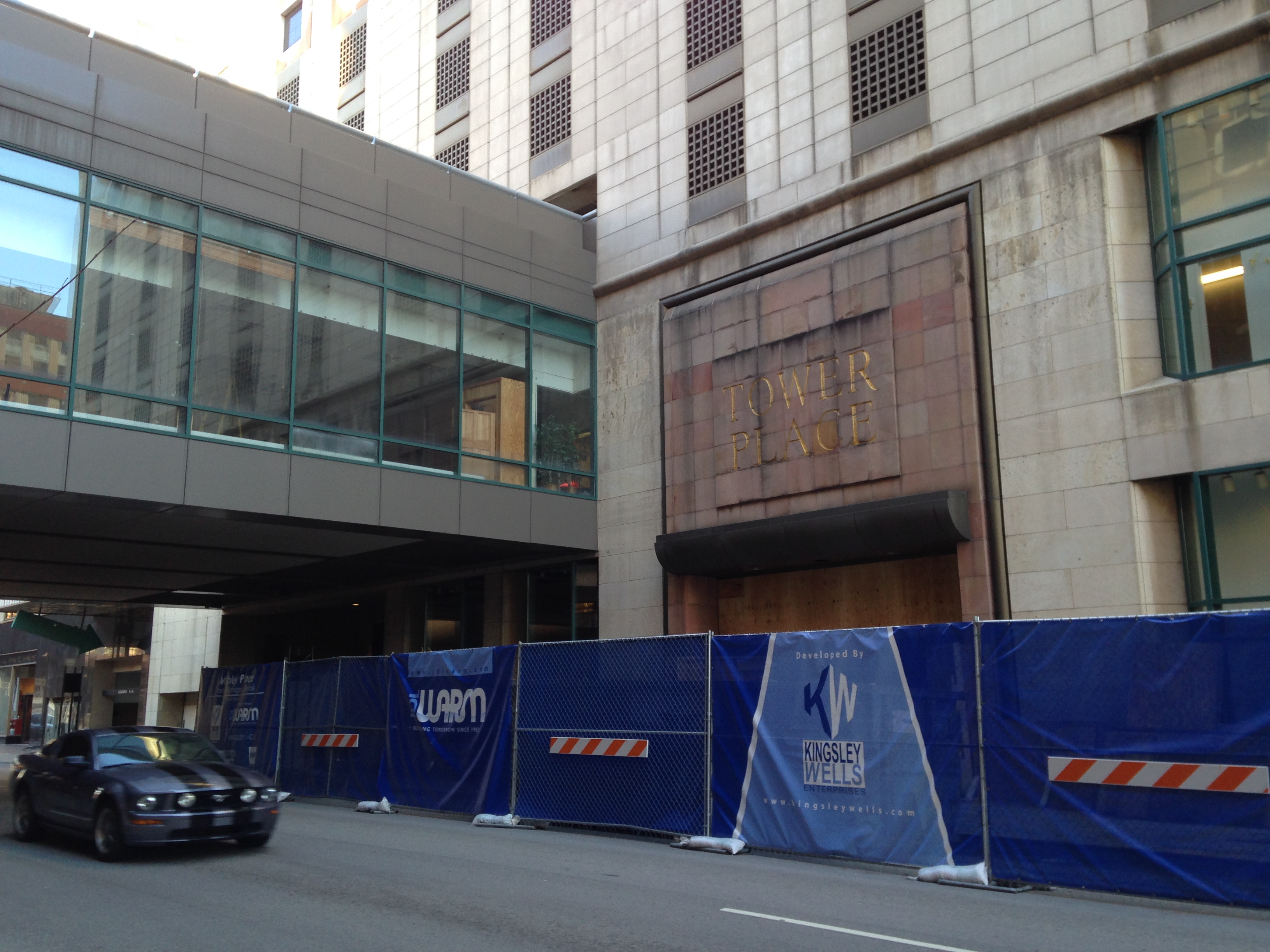
Demolition and reconstruction of the old Tower Place Mall, now named Mabley Place, began December 16 with the installation of construction fencing around the perimeter of the old mall at Fourth and Race Streets.

Demolition of Pogue’s Garage, however, will not begin until the conversion of the mall is complete. Once the parking garage is removed, it will clear the way for construction of the 30-story apartment tower planned for the site.

Tower Place Mall, which was purchased by the city early last year for $8.5 million, came attached with the deteriorating eight-story Pogue’s Garage. Originally constructed to serve as parking for the namesake department store across the street at the intersection. The department store closed and was replaced by the mall in the 1980’s.

The mall building also supported its own parking expansion that currently is only accessible via a skybridge from the Pogue’s Garage. The parking spaces above the old mall will remain open during construction.

“The 525 parking spaces that currently exist above Tower Place Mall must be able to be accessible by other means prior to the demolition of the Pogue’s Garage. Right now, the only way to access those spaces is through Pogue’s, so the interior ramping at TPM must be completed first,” explained Stephen Dronen with the city’s Department of Trade and Development.

City officials expect the $5 million Mabley Place project to take six to nine months, and are optimistic that the parking structure will open by June. In addition to the parking, the project will include 8,400 square feet of street-level retail. One retail space has already been leased.

From there, developers of the Pogue’s Garage site can begin the laborious task of taking down the parking structure.

Due to its close proximity to other buildings, and the fact that it does not have a basement, engineers say that the garage cannot be imploded and must rather be demolished conventionally. The city estimates the demolition will take about four months and should begin this summer.

Flaherty & Collins is the lead developer on the new 300-unit apartment tower that will also include 1,000 parking spaces and 16,000 square feet for an independent upscale grocery store.

Construction is expected to commence immediately following the demolition of the garage, with the potential for a tiered opening of the garage prior to the residential tower above. Under such a model, the grocery store and parking garage components could open in early 2016, while the high-rise residential tower would open near the end of 2016 or the beginning of 2017.

Although the redevelopment project was originally planned to be funded through the long-term lease of the city’s parking assets, the deal evolved to no longer require funding from the now cancelled lease. As a result, the project is being funded private financing and a $12 million forgivable loan that, city officials say, is contingent on the satisfactory completion of the project and completion and operation of a first-class grocery store on the ground retail floor of the project for at least five years.

Photographs by Elizabeth Schmidt for UrbanCincy.

Categories
Business Development News Politics Transportation

Is the Eastern Corridor Project a Trojan Horse for an Extension of I-74?

The Eastern Corridor Program has been part of Cincinnati’s political landscape since 1999. That year the Ohio, Kentucky, Indiana Regional Council of Governments (OKI) completed a Major Investment Study that envisioned construction of a new expressway between I-71 and I-275 and commuter rail service on existing freight railroad tracks as a multi-modal solution to limited east-west travel in eastern Hamilton County.

But are the incremental upgrades planned for Red Bank Road that appeared in the Ohio Department of Transportation’s (ODOT) December 21, 2013 Preferred Alternative Implementation Plan part of a long-term plan to extend Interstate 74 across Hamilton County and east to Portsmouth, OH?

A veteran of Cincinnati transportation planning thinks so. Speaking on terms of anonymity, a source claims that he was approached in the mid-1990s by Hamilton County officials and out-of-state toll road builders who sought to extend I-74 from its current terminus in Cincinnati at I-75 to SR 32 in Clermont County.

According to the individual, the Eastern Corridor Program charts a different route for I-74 across Hamilton County but it achieves a similar end. Specifically, it aims to open eastern Hamilton County and Clermont County to development in a way that interstate-quality upgrades to SR 32 east of I-275 could not alone achieve.

Extension of I-74 east to Portsmouth was widely discussed in the Cincinnati media in the early 1990s. On November 11, 1991, The Cincinnati Post reported that the newly passed Intermodal Surface Transportation Efficiency Act of 1991 named “an extended I-74 – and a new I-73 between Detroit and Charleston, SC, through Ohio – as one of 21 high-priority corridors”.

Planning for new sections of I-74 began in the early 1990s in North Carolina, and today 122 miles of I-74 are now open in that state.

While ODOT has never explicitly studied an I-74 extension, it did begin planning I-73 immediately after passage of the highway bill. This planning took place in an unorthodox manner when, in 1991, former Ohio Governor George Voinovich (R) directed the Ohio Turnpike Commission (OTC) – not ODOT – to study construction of a new interstate highway connecting Toledo, Columbus and Portsmouth.

An 80% toll hike in 1995 raised suspicions that construction of I-73 was imminent, however the OTC ended its planning 1997. This event appears to have coincided with West Virginia’s decision to slowly build its section of I-73/74 as a public/private partnership with various coal companies. With the end of I-73 planning also went any expectation that SR 32 might soon be upgraded to I-74 between Cincinnati and Portsmouth.

Since the conclusion of the Ohio Turnpike Commission’s study in 1997, ODOT has not explicitly planned for I-73 or the I-74 extension. However, many of its recent activities are consistent with the OTC’s plans in the 1990s.

On July 22, 2013 Governor John Kasich (R) announced that excess Ohio Turnpike toll revenue will fund construction of the $450 million Portsmouth Bypass, which was part of the Ohio Turnpike Commission’s 1990’s-era I-73 study, and is a critical link in the national I-73/I-74 plan. To be initially signed as SR 823, the Portsmouth Bypass will be a fully grade-separated and access-controlled highway – an interstate highway in everything but name.

No mention of I-73 or an I-74 extension appears on ODOT’s website; but an October 12, 2010 post on the National I-73/I-74 Association’s website named Steven Carter, Director of Scioto County (Portsmouth) Economic Development, as well as two officials from the Toledo area, as attendees at the association’s fall 2010 “Road Rally” in Washington, D.C.

Near Cincinnati, improvements to SR 32 are bringing the roadway closer to Interstate Highway design specifications. A new $32 million interchange is under construction at I-275, and the Clermont County Transportation Improvement District is studying full grade separation and controlled access from Batavia to the Brown County Line.

Within Hamilton County, ODOT divided a possible I-74 route into two separate projects: SR 32 Relocation and Red Bank Road upgrades. At an August 2011 public meeting, ODOT displayed drawings of Red Bank Road reconstructed as a fully grade separated and access controlled expressway. Those drawings do not currently appear on the project’s website.

New drawings shown at ODOT’s Oct 2, 2013 meeting and in its December 21, 2013 report are less ambitious but do not preclude a future full conversion of Red Bank Road into an interstate highway.

The project website states that the relocated SR 32 will “feel like a boulevard or parkway…it will not be a highway like I-71 or I-75”. However, no design feature presented to-date by ODOT prevents relocated SR 32 from being improved to full grade separation and limited access. In the meantime, planning and promotional activities for the future I-74 connecting the Midwest with the coastal Carolinas continue in earnest.

Editorial Note: In the coming weeks, we will publish two follow-up stories related to the Eastern Corridor Program. The first will take an in-depth look at the Portsmouth Bypass and West Virginia portion of the I-74 extension, and the second will provide an updated look at the program’s proposed Oasis Commuter Rail line.

Categories
Development News Transportation

Elm Street Cycle Track Would Provide Critical Link for Region’s Bike Infrastructure

The city will start construction on physically separated bike lanes along Central Parkway, from Downtown to Clifton, this coming spring. Following a community engagement process, a final design was selected in recent weeks, and the large addition to Cincinnati’s bike network is expected to make a significant impact.

Not only will it be one of the most impressive bike facilities installed in the region to-date, but it will also link neighborhoods together that have large percentages of bicyclists. Furthermore, it will link other bike facilities with one another, and come close to linking even more.

Some of the existing facilities include numerous bike lanes and the Mill Creek Greenway, but the Central Parkway bike lanes will come about 12 blocks shy of connecting with the Ohio River Trail, which then links to the Little Miami Scenic Trail.

A two-way cycle track should be built in order to connect the new Central Parkway bike lanes with the Ohio River Trail and beyond.

Elm Street Cycle Track

There are two streets that connect from Central Parkway to the Ohio River Trail along Mehring Way without interruption: Main Street and Elm Street. Both of the streets have one-way traffic heading northbound, but Main Street is considerably more congested with cars and buses heading to Government Square.

Elm Street, however, has some of the least congestion of any north/south street in the Central Business District and could easily connect the Central Parkway cycle track with the Ohio River Trail. A reorganization of the street would need to occur however.

Presently Elm Street, from Central Parkway to Mehring Way, lacks consistency in its design with on-street parking located haphazardly along both sides of the street. A reconfiguration of the street could consolidate all on-street parking to the east side of the street, thus eliminating only a nominal number of on-street parking spaces, and maintain 2 to 3 moving traffic lanes (the parking lane could be restricted during rush hours to allow for a third travel lane).

The Elm Street cycle track, meanwhile, would be located along the west side of the street and be buffered from moving traffic by a row of bollards. Such a redesign of Elm Street would be a bit of a road diet, but one that seems reasonable for this stretch of overbuilt roadway.

Planners with the City’s Department of Transportation & Engineering (DOTE) said that the idea of an Elm Street cycle track had not come up before, and has not been presented to any formal committees or community councils to-date. Such coordination, they say, would need to take place prior to the idea moving forward.

With future phases of The Banks and the yet-to-be-named residential tower on Fourth Street set to begin construction soon, there seems to be an opportunity to rebuild this roadway along with those projects. This would help offset some of the costs and make for a more seamless transition.

Projects like this are low-hanging fruit for the new mayor and council, should they wish to pursue investments that improve the city’s bike infrastructure. They should work with the bike community and come up with a strategy that provides a clear path forward to make this happen.

An Elm Street cycle track like this would provide a critical link in the region’s bike network, make the street safer, more accommodating to more users and more attractive to those who currently find themselves along the now bleak and desolate stretch of roadway. Let’s get to work.

Categories
Up To Speed

America’s infrastructure is spread far and wide, without enough people to pay for it

We Only Notice When the Pipes Burst – Next City.

As readers of UrbanCincy know, America has put off paying its infrastructure bills for some time and now has an increasingly terrible standard of roads, bridges, sewers, pipes, transit and energy. But what can or should communities throughout America do? They have infrastructure spread far and wide to support far-flung suburbs that defined The American Dream through much of the 20th century. While those early generations were able to sit back and enjoy the new suburbs, the bills of replacing this infrastructure are now coming due…and the communities are not densely populated enough to be able to properly fund the maintenance. More from NextCity:

Earlier this year, when the American Society of Civil Engineers released its quadrennial report card on the nation’s infrastructure, it gave a D to drinking water. The report estimated that there are 1 million miles of water mains in the country, some dating back to the mid-19th century and many in dire shape…Unlike bridges, roads or many other types of infrastructure, the pipes that carry our water are underground and out of sight. It’s only when they break — which, according to the ASCE, happens about 240,000 times each year — that people become aware of the problem.

“The top concern is our aging infrastructure and how we’re going to go about ensuring it’ll be around for future generations,” Kail said. “Over the next 25 years, it will cost U.S. communities more than a trillion dollars to repair water infrastructure. And by that I mean pipes in the ground. That’s a challenge for a lot of communities, especially small ones. Rural communities have many miles of pipes and not many people to spread the cost.”

Categories
Up To Speed

Where is the consistency and simplicity in design of pedestrian infrastructure?

Where is the consistency and simplicity in design of pedestrian infrastructure?.

Our friends and fellow Streetsblog Network compatriots at Streets MN have knocked it out of the park with their recently analysis and critique of pedestrian crossing design. Why do pedestrians need to press a button to activate a cross walk signal? Automobile drivers need not do the same. And why isn’t the design of our intersections simple enough so that pedestrians can easily and safely cross a street without needing 11 lines of instructions complete with images? More from Streets MN:

Traffic signals on streets with sidewalks (which implies pedestrian traffic either exists or is desired) should ALWAYS have an automatic walk phase, just as every cycle gives green time to cars from every approach. Actuators are fine if they make the walk signal come sooner, but being unpushed should not be used as an excuse not to have a walk phase at all. Car drivers don’t have to go out of their way to press actuators, why should pedestrians?

If traffic is so low you are concerned the time devoted to a pedestrian phase (~12 seconds – 36 ft at 3 fps) is too long (will cause too much vehicle delay) for this two lane roadway, maybe it shouldn’t be a signal but instead a stop sign (which requires no pedestrian signal) or a yield sign. This can be implemented with flashing red lights if you must you electrical gear.