Categories
Development News Politics Transportation

Induced Traffic Demand Works Both Ways

There is a popular saying that circulates in urban planning circles: “Widening roads to solve traffic congestion is like loosening your belt to cure obesity.”  Planners have shown over the past few decades that adding lanes to roads, while temporarily increasing flow, does little to address congestion because over time traffic demand continues to climb.  To understand it better, we have to understand the basics of traffic.

There are a few factors that determine a road’s level of service for automobiles.  There are capacity, the amount of cars that can fit on the road and maintain an adequate service, and flow, the rate at which cars pass the area under study.  Adding lanes increases capacity, but as development increases, so does demand.  This translates to more car trips and more cars on the road, which in turns leads to traffic engineers recommending adding more lanes.  The cycle repeats over and over again. David Owens highlights this in his book, Green Metropolis:

“When a city’s streets or highways become crowded, for example, the standard response is to create additional capacity by building new roads or widening existing ones. Projects like these almost always end up making the original problem worse—while also usually taking years to complete and costing many millions of dollars—because they generate what transportation planners call “induced traffic”: every mile of new open roadway encourages existing users to make more car trips, lures drivers away from other routes, and tempts transit riders to return to their automobiles, with the eventual result that the new roads become at least as clogged as the old roads, though at higher traffic volumes, and the efficiency of transit declines.”

This cycle can be seen all across suburban America.  In the Cincinnati area, there are cases where planned road widenings do not even meet future demand.  Take for instance the planned expansion of I-75.  By 2020, when construction is slated to finish, the level of service for the highway is projected to be exactly the same as it is now.  Traffic Engineers explain that this is due to…rising demand from automobile use.  It is clear that as long as America continues to spend money on roads, we will continue to facilitate demand for automobiles.

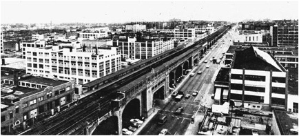
Fortunately the same is true with rail transit.  As pointed out by “The Provost of Cincinnati” on the now defunct Phoney Coney blog, we need only to look at the expansion of the New York City subway out to Queens in the 1920’s as one of the many reliable examples where investing in rail transit promoted growth.

The same location in Queens in the 1920’s (left) and 1940’s (right).

Other popular cases include:

  • The Washington DC Metro spawned millions of dollars in Transit-Oriented Development from Richmond, VA and all throughout the system.  Just recently, a massive $107 million dollar TOD development has broken ground in Northeast Washington DC.
  • The Portland Light Rail and Streetcar lines revitalized the Pearl District, an aging and blighted warehouse neighborhood close to downtown (Sound familiar?).   The area has seen over $3.5 billion in development since 2001.
  • The Charlotte Light Rail spawned over a half billion dollars in TOD development along the line.

In all cases, ridership has met or exceeded projections.  If traffic engineers were applying their same thinking to these systems, they would be calling for expanding these systems further, which is what is happening.

As Dan Bertolet writes at Publicola, “…we will be faced with a choice: Continue to build more roads and thereby preclude progress on alternative transportation, or stop building roads and accept that there is a limit to the number of cars we can accommodate if we hope to a create a balanced, sustainable transportation system and the compact land use patterns that support it.”

The argument is clear, we Americans can choose to waste our money on continuing a lifestyle that has led to increased isolationism, increased obesity and stress, and longer commutes to nowhere — or we can invest in the convenience, sensible and more healthy alternative of rail transportation.

John Yung is an Urban Planner and advocate for pedestrian friendly-planning. Currently the Zoning Administrator of the City of Bellevue, KY he specializes in Land Use Planning, Form-based Codes, Floodplain Management and Urban Forestry. John is currently pursuing a Masters Degree from the University of Cincinnati’s School of Planning.

If you would like to sound off about something for UrbanCincy’s weekly op-ed column, please submit your ideas to urbancincy@gmail.com.

Categories
Business Development News Politics

Hamilton County leaders eye land banking as potential cure for area’s housing woes

Our nation’s housing crisis and subsequent economic recession has led to an enormous increase in housing vacancy, abandonment, and foreclosures across the country. Hamilton County is no exception; the crisis has left many in the region homeless and has put a fiscal burden on local governments across the region, leaving them with the multifaceted challenges associated with widespread vacancy.

In many cases, property vacancy creates a domino effect that leads to further desertion and vacant properties within a neighborhood. This not only results in less tax revenue for cities; vacant property can also lead to increased rates of crimes such as drug dealing, prostitution, and arson. Because vacant property damages are so extensive, it is becoming more and more important for a metropolitan area to have a mechanism in place to transfer vacant property to owners who can/will pay taxes and redevelop the property.

A land bank is a tool that is growing in popularity, and on Tuesday morning local governmental and nonprofit leaders met to discuss how a Hamilton County land bank should be formed, funded and operated.

In April, Ohio Sub House Bill 313 was passed, enabling Ohio counties to create a Land Bank/County Land Reutilization Corporation (CLRC). The purpose of the CLRC is to facilitate the acquisition, reclamation, rehabilitation, and reutilization of vacant, abandoned, tax-foreclosed, and other real property. While there are still many steps that need to be taken before the CLRC is fully functional, county officials are hoping to have the land bank chartered by the end of the year.

Although no specific funding decisions were made at the meeting, there are multiple ways the CLRC can be supported fiscally. For example, the treasurer could recapture penalties and interest on delinquent taxes and assessments on behalf of the CLRC, the group could generate revenue from the resale of rehabbed property, and/or the CLRC could be authorized to issue bonds, accept gifts, and apply for grants. The recently announced NSP3 dollars can also be used to acquire homes for the CLRC.

Not only will the land bank help to address vacancy problems regionally, it will also give local CDCs and nonprofits a chance to obtain blighted property before private out-of-town investors. With a broad jurisdiction, the CLRC will be able to acquire both mortgage foreclosed and tax foreclosed properties. Moreover, the legislation allows land banks to waive delinquent taxes owed in order to clear the title on the property. This tax abatement component is crucial because often the taxes owed on abandoned property are more than the property’s actual market value.

At Tuesday’s meeting, there was a clear consensus that the land bank not just be a pilot program, but instead be a comprehensive and wide-ranging tool that helps to alleviate one of our region’s most pressing problems.

“The Board of County Commissioners want to ensure that the way this is set up is consistent with the community’s vision,” Assistant Hamilton County Administrator Jeffery Aluotto stated on Tuesday. “Land banking holds a great deal of promise as a means of addressing the increase in vacant housing stock we have seen since the recession, and the direct impacts that those vacancies have on the quality of life and economic vitality of our communities.”

With successes in Cuyahoga County and Gennessee County, Michigan, local leaders have high hopes for the potential impact that the CLRC can have on our region.

UrbanCincy will continue to follow this story as it progresses in the coming months.

Categories
Development News Politics

Cincinnati to host form-based code webinars at City Hall

Cincinnati leaders are hosting five webinars sponsored by PlaceMakers to give local residents a chance to learn more about the implementation of form-based codes. The sessions are intended to compliment the city’s ongoing effort at developing a form-based code.

According to Vice Mayor Qualls’ office, the webinars will take place on the third Thursday of each month starting October 21, 2010 and running through February 17, 2011. Each training opportunity will have its own unique focus led by specialists in that area.

On October 21, Ken Groves and Chad Emerson will look at the Montgomery case study. Dan Slone will then discuss how to integrate a form-based code with an existing code on November 18. The webinar on December 16 will include a discussion about SmartCode calibration basics led by Susan Henderson. At the second-to-last webinar Galina Tachiva will look at how to repair sprawl development patterns, and the final event will look at the Miami case study with the help of Marina Khoury.

The 75-minute webinars will be held at 2pm at City Hall (map). Those interested in attending the free sessions are asked to contact Jennifer O’Donnel at jennifer.o’donnell@cincinnati-oh.gov.  City Hall is accessible by Metro bus service (plan your trip), and free bicycle parking is available in the immediate surroundings.

Categories
Business Development News

Fay Apartments to be renamed The Villages of Roll Hill, undergo $36M renovation

Developers and city leaders kicked off a 30-month long rehabilitation project at Fay Apartments yesterday morning on the city’s west side. Once complete, the project will reduce the total number of housing units and become the largest green renovation of an affordable housing community in the United States.

In addition to a $36 million face-lift that will include the demolition of 17 buildings, the community has also been renamed The Villages of Roll Hill. At this time, city officials say that it has yet to be determined if the new community name will impact the official city neighborhood name of “Fay Apartments”, but early indications seem to indicate so.

Community leaders have been looking at rehabilitating the affordable housing community (map) for nearly five years. The latest version of the plan soon to be realized will reduce reduce the number of housing units from 893 to 703 and upgrade security measures, add new landscaping and trees, and include new playgrounds for the many children that live in the community.

The project was made possible through federal funds including a $32 million loan from the Department of Housing & Urban Development and a $3.2 million loan from City HOME. The City of Cincinnati has also granted an eight-year tax abatement on the renovation work.

Developers from Cincinnati-based Wallick-Hendy Properties are seeking Leadership in Energy and Environmental Design (LEED) certification for the project, but stated last year that the level of green improvements would be dependent upon government support.

Categories
Business Development News

Google updates aerial imagery of Cincinnati region

Google has updated its aerial imagery for several major cities throughout the United States including Portland, Washington, D.C., and Cincinnati.  The new imagery appears to have been taken over the summer.  Observers in the nation’s capital have been able to narrow it down to as precise as Sunday, August 29 between 1:00pm and 1:35pm.

Like many other cities around the country, the new aerial imagery for Cincinnati illustrates much of what has changed over recent years.  New construction projects are visibly taking place while others have been completed or are nearing completion in their aerials.  In addition to capturing the changing urban landscape in Cincinnati, the new imagery is also much crisper than previous versions.

Below is a sampling of 20 sites around the city that illustrate the aforementioned changes.  Enjoy!