Categories
News Transportation

Phase One of Ohio River Trail West Secures $1.3M in Funding

River West Working Group has announced that the western leg of the Ohio River Trail through Cincinnati has been awarded a $1 million Federal Congestion Mitigation/Air Quality grant. An additional funding commitment of $261,000 from the City of Cincinnati’s Bicycle Transportation Program brings the total to $1.3 million.

Project leaders say that the money will be put toward construction of the first phase of the bikeway and greenway project along Cincinnati’s western riverfront.

“We greatly appreciate the initiative of the City’s Department of Transportation & Engineering in developing and submitting the grant application, and the support of Mayor John Cranley, who set up the bike program funding that seeded the Federal grant,” said Tom Croft, co-chair of River West Working Group.

Croft, a Price Hill community activist, also credited the work of ODOT, OKI Regional Council of Governments, State Senator Bill Seitz (R), and Representatives Bill Blessing (R) and Lou Terhar (R).

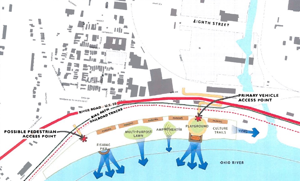
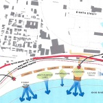
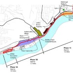
The first phase of work will extend roughly 3.7 miles downriver from the planned Price Landing park to the Gilday Recreation Center. The recently allocated funds will go toward constructing more than half of this phase of work.

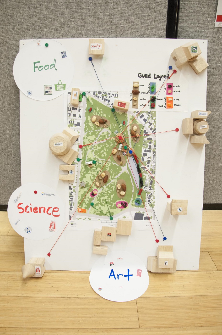
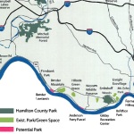
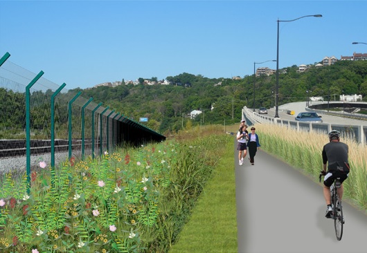
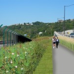
The overall plan for Ohio River Trail West is a 28-mile bikeway and greenway network, separated from nearby roads, that serves as a connection between Smale Riverfront Park and Shawnee Lookout.

The river alignment of this trail makes it unique to any other east/west corridor on Cincinnati’s west side in that it does not traverse steep or extended hills. Such an orientation will allow cyclists the opportunity to get to the trail and have a level path into the city center.

Due to the relationship of the project to the existing freight railroad lines, project leaders say that additional coordination is needed before the group is able to move forward with the third segment of work within the first phase of construction activities.

“We are not going to announce work on that until we have negotiated some type of agreement”, Dave Zelman, co-chair of River West Working Group told UrbanCincy.

Further complicating matters is that the City of Cincinnati recently worked with the freight railroad companies to rebuild the four tracks along that stretch in recent years. Regardless, neighborhood leaders and project proponents are confident that the work will progress and serve as a major benefit for the communities along the corridor.

“The Ohio River Trail West is a big factor in the ongoing revitalization of our western Hamilton County neighborhoods, many of which are underserved by this kind of amenity,” concluded Zelman. “It will encourage access to the Ohio River and its surrounding hillsides, our greatest natural assets.”

Categories
Development News

Mt. Airy Looking to Transform Part of Colerain Avenue Into Walkable Business District

On October 30, Klosterman’s Dry Cleaners, in the heart of the Mt. Airy neighborhood business district, was torn down. Long seen as an eyesore, the demolition was heralded by community leaders hopeful that it would spark a revitalization movement along the quarter-mile stretch of Colerain Avenue.

The demolition project came as part of the City of Cincinnati’s most recent award-winning Neighborhood Enhancement Program where various departments work together to improve neighborhoods through blight removal and code enforcement. It was funded through a $55,000 grant from the Department of Trade & Development and acquired through the Hamilton County Land Reutilization Corporation.

This is the first phase of a more comprehensive plan to redevelop the district that was put together by the Mt. Airy Community Urban Redevelopment Enterprise (C.U.R.E.), CR Architects, Urban Fast Forward thanks to a $30,000 grant from the City of Cincinnati. The Mt. Airy Revitalization Strategy was completed in March 2013 and provides a four-phase vision to enhance the business district.

The 20-page report concludes that buildings separated from the street by parking on the western side of Colerain Avenue have diminished the quality of the business district. The authors of the report also point to the prospects of implementing a form-based code for the area.

“Ideally new construction in Mt. Airy would apply the principles of a form-based code, at least in such matters as relationship of the building to the sidewalk and the placement of parking,” the report stated. “This will protect and build upon the existing good of the business district and help to give Mt. Airy a unique character as a neighborhood.”

Leadership at Mt. Airy C.U.R.E. says that the demolished dry cleaner will allow for the creation of a new centrally located parking lot in the business district that will also function as a gathering space for community events. The second phase of work, which community leaders hope can be completed by the end of 2015, will make streetscaping improvements and look to address existing storefronts.

“The existing conditions of the facades and storefronts are not that good,” Gerald Fortson, Senior Development Officer at Cincinnati’s Department of Trade & Development, told UrbanCincy. “Upgrading them will allow property owners to attract the caliber of tenants the district desires.”

Phases three and four of the plan call for more aggressive action through the development of new structures along the western side of the street currently dominated by auto-oriented buildings.

As part of phase three work, a vacant lot and an existing 3,200-square-foot structure would be torn down and replaced by a new street-fronting 3,500-square foot retail building and a 24-space parking lot. Then, in phase four, two structures totaling 9,400 square feet of retail space would be razed to make way for a new 7,500-square-foot retail building that would also front onto Colerain Avenue. This part of the plan also calls for the creation of a new mid-block crossing for pedestrians.

“We hope to make this area a place that could encourage people to slow down and to see the business here,” explained Corless Roper, President of Mt. Airy C.U.R.E.

Over time neighborhood officials also hope to develop a wayfinding system and branding for one of the west side’s rare neighborhood business districts. If all goes according to plan, the whole revitalization program could be complete within five years.

“This is an exciting opportunity for Mt. Airy to rebrand and market itself in a new light, focusing on a safe and clean community that will draw our diverse neighborhood together, and eventually attract new businesses as we achieve the phases in our plan,” Roper stated. “Moving forward, we will creatively launch a campaign to raise funds in order to make our dream a reality, knowing that Mt. Airy is on the move!”

Categories
Development News

UC’s Niehoff Urban Studio Takes Bold New Look at the Future of Burnet Woods

On December 4, the University of Cincinnati Niehoff Urban Studio hosted an end of the semester open house to showcase the final work of students in graduate planning, civil engineering capstone, and a multi-disciplinary freshman UC Forward seminar.

There were three classes offered at the Studio, located in Corryville, during the Fall Semester that focused on understanding and improving Burnet Woods. The aim, course leaders say, was to begin to produce a future vision for the 89-acre park.

City officials first began discussing an overhaul of Burnet Woods in 2007, but a lack of funding at the time doomed the project. However, Mayor John Cranley (D) made the project a priority in his inaugural State of the City Address, saying that the park, located immediately north of the University of Cincinnati’s main campus, could help make the uptown area an even greater destination.

“Burnet Woods is an underutilized gem in our parks system,” Cranley said in a statement. “It’s nice now, but it could be great.”

That caught the attention of UC President Santa Ono, along with the Uptown Consortium who requested that the studio work on the subject in consultation with community representatives and other stakeholders uptown. In addition, staff of the Cincinnati Park Board, who have sole control over what will happen with the park, have been engaged with the studio throughout the semester.

A large crowd showed up at the open house, held two weeks ago, to take a look at the visuals and learn about the observations and initial recommendations produced by the students for the roughly 142-year-old park.

After identifying various issues with Burnet Woods, as it stands today, the students proceeded to “rethink” the space and its uses. Nine teams of graduate Planning students organized their work around distinct thematic approaches to remaking the park. These themes included integrated Art Programming, a Health/Wellness destination, a food production system, a center for “fun” programming, and others.

Some of the many specific recommendations included creating seasonal programming, creating a soundscape as a placemaking tool, inserting a winding promenade to connect UC Main Street with the Ludlow Business District, elevating Martin Luther King Drive to allow for Burnet Woods to flow through underneath it into UC’s main campus, among others.

Some of the student teams extended the scope beyond the park by suggesting a cohesive streetscape experience extending from Burnet Woods and re-imagining the park as the center of an Uptown “eco-district” to create a broader ecological and social system.

One of the benefits of the studio course offerings came from engaging both planning and engineering students. As part of the course’s focus on building healthy and resilient places, civil engineering students proposed a number of green infrastructure ideas to help with stormwater runoff and combined sewer overflows, and other technical projects.

Additionally, according to Frank Russell, Director of the Niehoff Studio and Community Design Center, the multi-disciplinary UC Forward freshman seminar was able to survey the student body to determine its interest in the park and ended up proposing a student organization dedicated to providing advocacy and service to the park.

Russell says that this is only the beginning, with additional courses in Planning, Architectural Engineering, Civil Engineering, and Horticulture to come in the Spring Semester that will build on the ideas and research completed thus far. The hope, he says, is to create a well-grounded set of ideas that will make up the contents of an ‘idea book’ for use by the community in considering the future of Burnet Woods.

Other faculty involved in the Fall Semester included Vikas Mehta and Danilo Palazzo from the School of Planning; Richard Miller and Elizabeth Devendorf from the Civil Engineering Program; and Cory Christopher from UC Forward. Those interested in viewing the student work in detail may do so by appointment at the UC Niehoff Urban Studio, located at 2728 Vine Street, by emailing design.center@uc.edu.

Categories
Development News

West Side Leaders Land $46k for Long-Planned ‘Price Landing’ Park Along Riverfront

River West Working Group and Price Hill Will announced last month that they have received two grants to create a park framework plan for Price Landing, an integral piece of the overall western riverfront vision.

The first is a $30,000 grant from Interact for Health, and the second is a $16,000 grant from the Greater Cincinnati Foundation. The combination of the two will allow for the development of a vision and preliminary design for the park that would become the eastern bookend of the Ohio River Trail West.

Cincinnati’s western riverfront spans 22 miles from downtown to Shawnee Lookout, and Price Landing is seen as a critical step in reclaiming the riverfront ecosystem as a recreational and educational experience, rather than industrial.

Glaserworks and Human Nature have been hired to create the plan for the park, which will include major park features and a preliminary budget for the construction of the project. River West Working Group will manage the design process in coordination with both firms; and they say the goal of the process is to complete the park framework plan by the middle of 2015.

“This is a very exciting addition to the many positive developments driving the ongoing revitalization of our West Side neighborhoods,” said Tom Croft, Co-Chair of River West Working Group. “With the creation of Price Landing, and the expansion and renovation of the Cincinnati Recreation’s nearby Evans Fields, Lower Price Hill will be a true recreation destination.”

Having advocated for the park since 2007, River West Working Group says their mission is to foster communication among West Side neighborhoods about development and land use issues, and to promote proactive strategies to make Cincinnati an attractive place to live and work.

In fact, the group was founded during the debate over the approval of the controversial Queensgate Terminals project. That project, which is the same site as Price Landing, would have brought a modern rail-to-barge transfer facility to the area.

In 2009 Croft said the development of Queensgate Terminals would “consign Lower Price Hill, East Price Hill, Sedamsville and Riverside to permanent blight”, and would damage perceived recovery efforts taking place at the time.

“[This site] is located at key gateways to and from West Side neighborhoods,” Croft said at the time. “In accord with the Cincinnati Scenic View Study adopted by City Council last summer, it must be protected because of its position in the line of sight from Mt. Echo and the City.”

So far the group has been quite successful. In addition to the Queensgate Terminals project being scuttled, work has also progressed on the Ohio River Trail West, and Price Landing will permanently ensure that a critical piece of riverfront property will not be developed as an industrial use.

According to Dave Zelman, co-chair of River West Working Group, the progress is something to be celebrated, saying, “With planning well underway to link Lower Price Hill to the Gilday Recreation Complex in Riverside, this park will serve as a gateway to western Hamilton County, and be a positive addition to our region.”

Categories
Arts & Entertainment News

Christkindlmarkt Returns to this Popular Cincinnati Landmark

CKM 2014 Dates_locationsStill missing German traditions after Oktoberfest? Want some energy and warmth in the freezing cold? The Cincideutsch Christkindlmarkt -Cincinnati’s premier holiday event- kicked off the holiday season this past weekend.

First held in 2012, this is the third year for the holiday market, which is a German tradition that dates back centuries at Europe. But only just began in Cincinnati in 1988 when the Germania Society introduced the city’s first German-style Christmas market.

“One of my favorite memories from living in Augsburg, Germany was heading to the Christkindlmarkt after work for a cup of warm, spiced wine,” explained vice president and co-founder Linda McAlister. “After I founded Cincideutsch with Peter and Olaf, I wanted to bring these fond memories to life here in Cincinnati.”

Christkindlmarkt literally translates from the German language to “Christ Child Market.” These markets originated in Germany and Austria and are now held all over the world. They typically occur in town squares where vendors sell sweets, warm drinks, and seasonal decorations for the holidays.

In Cincinnati the event is once again being held at Fountain Square, where wooden booths have been erected for vendors to sell a range of items for gift-giving, decorating, eating and drinking. While walking through it, you can sense the rich German culture by tasting tradition holiday sweets, sampling a piece of European baked goods, bringing home some handcrafted gift or seasonal decoration, or by warding off the cold with a warm cup of Glühwein.

Cincinnati’s Christkindlmarkt will be complimented by live music, sparkling lights and ice skating. Live entertainment will be scheduled each day in hope to satisfy the more than 15,000 expected visitors.

Like last year, the market celebrated its opening on Thanksgiving weekend at Fountain Square in conjunction with Macy’s Light Up the Square and Downtown Dazzle, which features the annual lighting of the holiday tree and draws thousands of people from across the region.

It was a success last year with the following weekends moving to Findlay Market, this year, in order to seeking for expansions, Cincideutsch had hoped to move to the Schmidlapp Event Lawn at Smale Riverfront Park for the second two weekends because it’s an up-and-coming area and there are plans for even more expansion.

“If we want to make the market bigger, it would be a good place.  But, we were informed that some drainage issues needed to be taken care of ASAP, so Fountain Square and 3CDC have been great in allowing us to stay on the Square for the entire time.” Linda told UrbanCincy, “We’re also lucky to be sponsored by some great local companies, including American Modern Insurance Group, Christian Moerlein Brewery, Ruthman Companies, Siemens, and UBS.”

The Christkindlmarkt opened at Fountain Square for the Thanksgiving weekend (November 28-30) but continues for the following two weekends (December 5-7 and 12-14). Fountain Square is easily accessed by Metro buses from nearby Government Square. There is also a RedBike station on the square for bike share access.