Categories
News Transportation

Wanderu Introduces One-Stop Booking Site for Intercity Bus, Train Operators

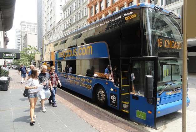
For years, travelers have been able to compare prices and schedules between multiple airlines in one place by using sites like Kayak.com. With the rising popularity of intercity bus options like Megabus and BoltBus, it has been a wonder why a similar functionality was not in place for those modes of transportation.

Until recently, there was no site that offered this service. Comparing these providers required making a separate trip to each company’s website – much like one must make separate trips to each individual carrier’s terminal or station.

Wanderu, however, was launched in 2012 and solves this problem by aggregating schedules from dozens of bus and rail services, including Amtrak, Boltbus, Megabus, and Greyhound. Wanderu originally focused on the northeastern United States but the site’s coverage now stretches across the country. After launching services in the Midwest in August of last year, co-founder Polina Raygorodskaya reached out to UrbanCincy to explain how it all works.

“Wanderu is the simplest way to find and book bus and train travel,” Raygorodskaya wrote. “We are the first ever comprehensive ground travel search in North America and have partnerships with Megabus, Greyhound, Boltbus and over 28 other major brands to help millions of people find and book the best trip at the best price in just a few clicks.”

We recently tested out the site by looking for travel options from Cincinnati to Cleveland on the morning of Monday, March 9. As a comparison, we also searched Kayak.com for flights on the same date.

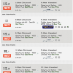
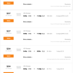
Wanderu presented us with several Greyhound and Megabus options, with prices starting at just $1 and a travel time of around five hours. On the other hand, the cheapest flight available was $221 on US Airways, and still took over 9 hours as it required two layovers. The cheapest flight with only one layover was $284; and there were oddly no direct flights available for this busy route.

We also searched Wanderu for trips to other destinations, and were able to find service from additional carriers such as Barons Bus Lines.

While the service is akin to Expedia, it is a bit different in that when you select a trip on Wanderu you are sent off to the carrier’s website to make the purchase. Raygorodskaya says this is because Wanderu is not set up to handle the financial transaction.

An added convenience that could be added is the ability to book all aspects of a trip, including hotels and rental cars, the same way that sites like Kayak.com or Expedia allow. An even better service might be to create an integrated search of all travel options – bus, rail, and air – so that users can compare them side-by-side.

Until then, if you are looking to take a trip without the hassles of airport security and expensive in-flight wi-fi, you can search Wanderu to find the bus or rail option that best fits your needs.

Categories
Development News

Mt. Airy Looking to Transform Part of Colerain Avenue Into Walkable Business District

On October 30, Klosterman’s Dry Cleaners, in the heart of the Mt. Airy neighborhood business district, was torn down. Long seen as an eyesore, the demolition was heralded by community leaders hopeful that it would spark a revitalization movement along the quarter-mile stretch of Colerain Avenue.

The demolition project came as part of the City of Cincinnati’s most recent award-winning Neighborhood Enhancement Program where various departments work together to improve neighborhoods through blight removal and code enforcement. It was funded through a $55,000 grant from the Department of Trade & Development and acquired through the Hamilton County Land Reutilization Corporation.

This is the first phase of a more comprehensive plan to redevelop the district that was put together by the Mt. Airy Community Urban Redevelopment Enterprise (C.U.R.E.), CR Architects, Urban Fast Forward thanks to a $30,000 grant from the City of Cincinnati. The Mt. Airy Revitalization Strategy was completed in March 2013 and provides a four-phase vision to enhance the business district.

The 20-page report concludes that buildings separated from the street by parking on the western side of Colerain Avenue have diminished the quality of the business district. The authors of the report also point to the prospects of implementing a form-based code for the area.

“Ideally new construction in Mt. Airy would apply the principles of a form-based code, at least in such matters as relationship of the building to the sidewalk and the placement of parking,” the report stated. “This will protect and build upon the existing good of the business district and help to give Mt. Airy a unique character as a neighborhood.”

Leadership at Mt. Airy C.U.R.E. says that the demolished dry cleaner will allow for the creation of a new centrally located parking lot in the business district that will also function as a gathering space for community events. The second phase of work, which community leaders hope can be completed by the end of 2015, will make streetscaping improvements and look to address existing storefronts.

“The existing conditions of the facades and storefronts are not that good,” Gerald Fortson, Senior Development Officer at Cincinnati’s Department of Trade & Development, told UrbanCincy. “Upgrading them will allow property owners to attract the caliber of tenants the district desires.”

Phases three and four of the plan call for more aggressive action through the development of new structures along the western side of the street currently dominated by auto-oriented buildings.

As part of phase three work, a vacant lot and an existing 3,200-square-foot structure would be torn down and replaced by a new street-fronting 3,500-square foot retail building and a 24-space parking lot. Then, in phase four, two structures totaling 9,400 square feet of retail space would be razed to make way for a new 7,500-square-foot retail building that would also front onto Colerain Avenue. This part of the plan also calls for the creation of a new mid-block crossing for pedestrians.

“We hope to make this area a place that could encourage people to slow down and to see the business here,” explained Corless Roper, President of Mt. Airy C.U.R.E.

Over time neighborhood officials also hope to develop a wayfinding system and branding for one of the west side’s rare neighborhood business districts. If all goes according to plan, the whole revitalization program could be complete within five years.

“This is an exciting opportunity for Mt. Airy to rebrand and market itself in a new light, focusing on a safe and clean community that will draw our diverse neighborhood together, and eventually attract new businesses as we achieve the phases in our plan,” Roper stated. “Moving forward, we will creatively launch a campaign to raise funds in order to make our dream a reality, knowing that Mt. Airy is on the move!”

Categories
Up To Speed

Prefabricated tiny living spaces are on their way to America’s biggest city

Prefabricated tiny living spaces are on their way to America’s biggest city.

While the concept of living in micro-apartments is not new to many cities around the world, it is a fairly novel concept in North America where large dwelling units have traditionally dominated the marketplace. That, however, is changing and we are excited to be covering the emergence tiny living in Cincinnati. Meanwhile, New York City will soon celebrate the arrival of its first prefabricated “microunits” that will make up the city’s first tower of such apartment units. More from The Atlantic:

For another, this will be the city’s first “microunit” building. In 2013, its design won a city-sponsored “micro-housing” competition devoted to compact housing for single occupants. (Forty-six percent of Manhattan households are made up of one adult.) The architects, Eric Bunge and Mimi Hoang, hope that large windows, high ceilings, and floor plans featuring multipurpose living areas—fold-up furniture sold separately—will make the apartments feel more spacious than their 255 to 360 square feet.

Bunge says that drafting a modular, microunit building is, in terms of complexity and precision, something like designing a car. The little boxes flirt with minimum-habitable-space laws as well as mandates regarding disability access, so there is absolutely no room for error. “If we were to … change drywall from half an inch to five-eighths,” he says, running his fingers across some plaster, “we’re screwed.”

Categories
Development News

$11.2M Redevelopment of Historic Heberle School to Breathe New Life Into West End

A team of New York-based developers have purchased a number of properties in the West End, and a recent tax credit from the State of Ohio may spark the first major redevelopment investment in the historic district in decades.

In 2012, Zada Development purchased two historic school buildings from Cincinnati Public Schools for $60,000 each at auction. The two schools sit within a block of one another in the Dayton Street Historic District, and have sat vacant for the better part of the last decade.

The development team told UrbanCincy that they intend to begin construction on the 86-year-old Heberle School in February, thanks to a $1.8 million Ohio Historic Preservation Tax Credit – the biggest award in the recent round of funding in Southwest Ohio aside from Music Hall’s $25 million catalytic project award. It is due to the neighborhood’s proud history that the developers decided to enter the Cincinnati market and take on their first project here.

“This area has been abandoned for some time, which prompted us to collaborate with the Dayton Street Neighborhood Association in order to revive a community rich in history and architecture,” explained Golan Marom from Zada Development Group.

The group’s previous experience is largely comprised of high-rise residential rehabilitations in the New York area.

The $11.2 million Heberle Lofts project, meanwhile, is seen as phase one of the team’s efforts. The second phase will focus on the 100-year-old Lafayette Bloom Middle School on Baymiller Street. There, developers anticipate a project similar in scope to what will be done at Heberle, which is planned to include 59 market-rate apartments and 5,000 to 6,000 square feet of street-level commercial space.

A striking similarity at both school properties is the large open space in front of their main entrances. In both cases, Marom says that the plan is to maintain some of it as parking for the development, while also creating new public and green space for the community.

While redevelopment has been moving northward from Over-the-Rhine’s Gateway Quarter, all the way up to the Brewery District surrounding Findlay Market, it has yet to spread west into the West End or its Brighton District. An injection of activity like this, however, could improve the neighborhood’s ability to support service retail and restaurants, which so far have proved difficult to attract within the Brighton District or along Linn Street at the nearby City West development.

The development team says they are still working to secure some additional financing, but are optimistic they will be able to get started in the coming months. Should everything go according to plan, the Heberle Lofts project is expected to be completed approximately two years after construction work begins.

Categories
Up To Speed

What if we calculated level of service for pedestrians?

What if we calculated level of service for pedestrians?.

Level of Service. Chances are, unless you’re in a field related to transportation planning or engineering, or are a total geek, you probably have not heard of this term before. LOS, however, has come to define how we design and build or roadways. Almost by its structure, LOS favors cars over the function or safety of any other mode of transportation. So what would happen if we took the same approach for other modes, like walking? More from Urban Kchoze:

The point of a traffic engineer in most studies is to keep level of service as low as possible to avoid delays for drivers, helping them drive faster and have to wait less for other traffic. Now then, some of you may ask “well, what about pedestrians and cyclists? How is level of service measured for them?” Well, the answer to that is that the default method says: F#!% ’em.

So let’s suppose that we calculate a level of service for pedestrians based on the same basis as for vehicles. Pedestrians can stop and accelerate to regular walking speed almost instantaneously and so we don’t have to calculate delay caused by lower than desired speeds during acceleration and deceleration. So delay is limited essentially only to the wait time before they can go ahead and cross (supposing car drivers respect pedestrian priority).

…crosswalks with medians and stop signs should be preferred to traffic lights for areas with a focus on pedestrians. It also means that the habit of channeling all the traffic on a few wide arterials, forcing each intersection to have multiple turn lanes and many through lanes, is absolutely terrible for pedestrians. A street grid with densely packed streets would do a better job of responding to all users, as it would dilute traffic on many streets, all these streets could be narrow, with 3 or 4 lanes only (1 per direction plus a shared left-turn lane or 2 per direction). Ideally, I believe there should not be any width of pavement greater than 12 meters (40 feet) in a city, any pavement wider than that should be broken in two with a median wide enough to use as a pedestrian refuge.