Categories
Business Development News Opinion Transportation

Reimagined Brent Spence Bridge alignment could prove to be financial windfall for Cincinnati

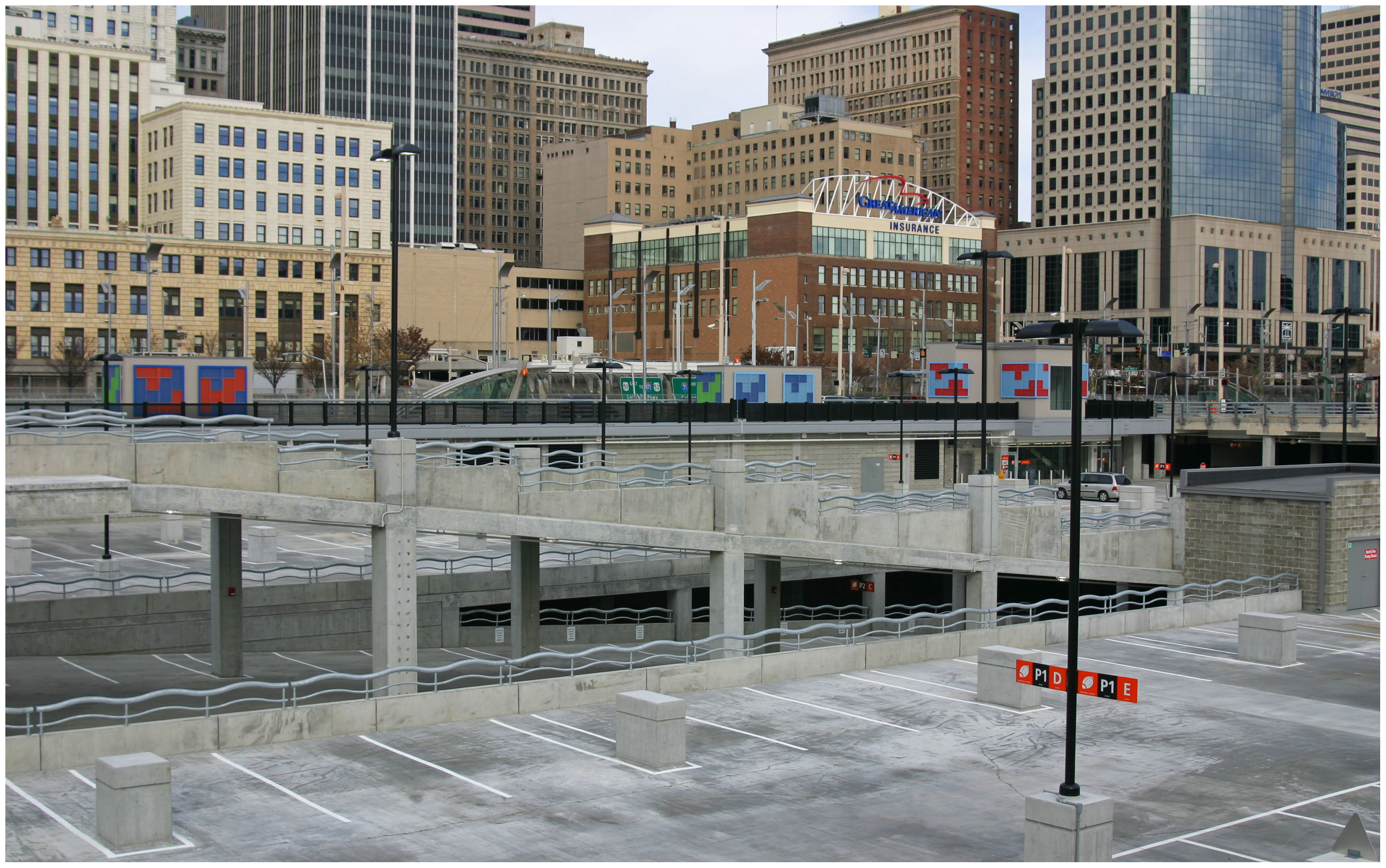
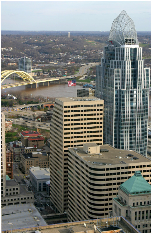
On Tuesday April 24 and Wednesday April 25 residents will have a chance to voice their concerns about the preferred Brent Spence Bridge design alternative, currently known as Alternative I at Longworth Hall. The proposal would build a new bridge adjacent to the existing Brent Spence Bridge.

The process, which began in 2004, has a nebulous future ahead of it with uncertainty pertaining to future funding from a new federal transportation bill. Recently, state officials have said that parts of the overall rebuild of I-75 through Cincinnati may be delayed for up to fifteen years. The new funding paradigm has left local leaders on both sides of the river talking about public-private partnerships. Because of this uncertain future, it may be possible to reexamine one of the bridge options not pursued.


More than two dozen new city blocks would be able to generate in excess of $200 million annually in property tax revenue alone, should the new Brent Spence Bridge be shifted west. Rendering from Revive I-75 Study.

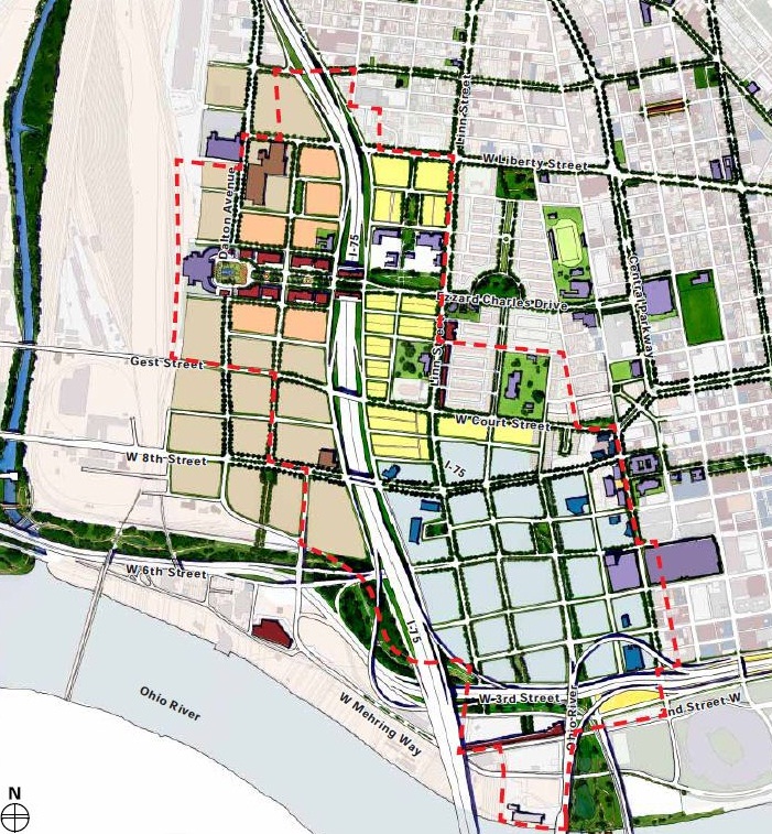
In 2010, the City of Cincinnati hired consultants to conduct several workgroups along the Interstate 75 corridor within the city limits. The study, named Revive I-75, addressed ways to mitigate the impact of the expanded highway on the surrounding urban neighborhoods. What also came out of the study was a visualization of the possible configuration of a new bridge for I-75 on the opposite side of Longworth Hall that would have allowed for the expansion of the Central Business District.

At the time there were several alignment configurations under study that would have moved the new bridge west of Longworth Hall, shrinking the amount of land the spaghetti-like on ramps use to connect I-71 to I-75 and the bridge. These alternatives were embodied in Alternatives A & B in the Brent Spence Bridge Corridor study. Yet both alternatives were removed from consideration citing environmental impacts and cost concerns. One of the arguments raised in opposition to the proposal was that that the city would lose valuable tax revenue from the affected industrial businesses in Queensgate.

However; according to urban economists such as Joe Minicozzi and Peter Katz, multi-story mixed use development actually brings in the most tax revenue for local jurisdictions when compared to single use facilities. In their study on Sarasota, Florida, it was found that a local mall generated only $22,000 in tax revenue per acre whereas a 17-story mixed use tower generated $1.01 million in tax revenue per acre. Since the 2010 study, Minicozzi has performed the same study in over fifteen different municipalities with similar results.

In a recent article written by Emily Badger, she summarizes several pertinent studies and surmises that, “We tend to think that broke cities have two options: raise taxes, or cut services. Minicozzi, though, is trying to point to the basic but long-buried math of our tax system that cities should be exploiting instead: Per-acre, our downtowns have the potential to generate so much more public wealth than low-density subdivisions or massive malls by the highway. And for all that revenue they bring in, downtowns cost considerably less to maintain in public services and infrastructure.”


Shifting the new Brent Spence Bridge to the west would allow downtown Cincinnati to be relieved from the existing and proposed entanglement of highway ramps. Rendering from Revive I-75 study.

A land use analysis performed by the UrbanCincy team found that the alternatives presented and illustrated in the Revive-75 documents would increase the amount of new land available in the Central Business District by roughly 33 percent. Approximately 25 new city blocks would be created under the proposal, freeing up land that is currently taken up by the expansive tangle of roadways that connect I-75, I-71 and the Brent Spence Bridge.

This would be accomplished by maintaining the ramps that connect I-71 to the Brent Spence Bridge and extending Fort Washington Way west, becoming the Third Street Expressway. This expressway will later align with the Sixth Street Expressway after connecting to the new bridge alignment west of Longworth Hall. The street grid would then be reestablished and developable real estate could be maximized on the newly reclaimed land. Based on the research provided from Minicozzi and Katz, UrbanCincy estimates that the taxable revenue capture could be more than $200 million from property taxes alone.

Such a move would not only allow for a sizable expansion of the Central Business District, but it would also create available land for a future expansion of the Duke Energy Convention Center. In a time when public agencies are trying to do more with less, this is a perfect opportunity to create more tax-productive property in the heart of the Cincinnati region. Moving the new bridge west is a solution that city, county and local business leaders should all support.

Categories
Business Development News Politics Transportation

Cincinnati City Council prepares to take action against urban parking mandates

Cincinnati Vice Mayor Roxanne Qualls (C) has introduced a motion co-sponsored by Councilmembers Laure Quinlivan (D), Chris Seelbach (D), Yvette Simpson (D), Cecil Thomas (D) and Wendell Young (D) to eliminate minimum parking requirements in historic Over-the-Rhine and the Central Business District.

Citing other urban examples such as Nashville, Portland, San Francisco, Seattle, and Tacoma, Qualls stated that, “Cities are recognizing that allowing the market to function will produce a better result. If a developer wants to build an 800-room hotel without providing any parking, that’s probably not going to meet the demands of the market. But if a developer can sell or rent his units without meeting minimum parking requirements, then there is no need for them.”

The motion cited that current regulations require at least one parking space per dwelling unit and that providing parking can be a costly impediment to developers looking to invest in older buildings in the region’s urban core. That motion has been referred to the Livable Communities Committee, chaired by Vice Mayor Qualls, and could go before the full city council soon after.


The new Central Riverfront Garage will soon be built over with new businesses, residences and even more parking mandated by law. Photograph by Randy A. Simes for UrbanCincy.

Chad Munitz, Executive Vice President of Development and Operations of the Cincinnati Center City Development Corporation (3CDC), estimates that parking mandates cost urban developers $5,000 for one surface parking space and $25,000 for a structured parking space on average. The increased cost associated with that parking, Munitz says, is then passed on to the consumer and raises the price of a residential unit by as much as $25,000.

The announcement comes just two weeks after UrbanCincy proposed three solutions for reforming Cincinnati’s urban parking policies. One of those solutions included the idea of eliminating minimum parking requirements.

Expanding on the impacts of eliminating parking requirements, Nashville urban planner Joni Priest indicated that removing parking minimums did not reduce the number of parking spaces developed for new downtown projects. Instead removing parking requirements allowed the preservation of historic buildings by allowing developers to become more creative in developing parking strategies such as shared off-site parking agreements, and it prepared the city for long-term transportation infrastructure improvements.

“Nashville has built two new parking structures in recent years – one in conjunction with the new downtown library and the other beneath a civic lawn in front of the county courthouse,” explained Priest. “These parking structures are near the oldest parts of downtown.”

Priest highlighted The Stahlman development as an example of a historic building that was revitalized because of the removed parking restrictions. The historic 12-story office building was rehabilitated into apartments, and sits directly across from the civic lawn that has parking beneath it. One parking space, Priest explained, is included in the rental price and additional spaces are available.

“The Stahlman has been a big success because it is a great building with a great view in the heart of a great city, but also because the developer was able to find a practical solution to a problem that plagues historic structures,” concluded Priest who went on to say that similar stories can be told for other developments near Nashville’s library garage.


Small businesses in neighborhoods like historic Over-the-Rhine often stuggle to provide minimum parking requirements drafted with suburban business models in mind. Photograph by Randy A. Simes for UrbanCincy.

The expansion and renovation of Washington Park offers a similar opportunity in Cincinnati’s historic Over-the-Rhine neighborhood where a great deal of new investment is taking place. Additionally, the results from Nashville seem to find that easing parking requirements would immediately make it easier to convert historic office buildings into residential uses.

The idea, policy makers say, is to allow the free market to operate within an urban context and allow cities like Nashville to anticipate increased demand for non-automobile forms of transportation.

“Removing the parking requirements from downtown zoning allows flexibility for site-specific and program-specific solutions. Flexibility is key in urban environments,” said Priest. “As downtown becomes more comfortable for pedestrians, cyclists and transit users, new development will have the flexibility to build less parking.”

As investment continues to spike in Cincinnati’s urban core, and construction work moves forward on the city’s new streetcar system, it becomes increasingly clear that the policy shift is more about lifestyle options than anything else.

“If you walk through Over-the-Rhine during a snowy winter, you’ll see cars in the surface parking lots covered with snow that has never been dusted off because they haven’t been driven in weeks,” Munitz said. “The convenience sought by downtown residents is not instant access to a car – it’s the ability to live without a car.”

Categories
Business Development News Transportation

Streetcar first step in Mayor Mallory’s regional rail transit vision

Last night Cincinnati Mayor Mark Mallory (D) shared some exciting information regarding the future of rail transportation in the Cincinnati region in his State of the City address. First he announced that Spanish-based Construcciones y Auxiliar de Ferrocarriles (CAF) had been selected to design and construct the first five streetcar vehicles for the Cincinnati Streetcar project currently under construction. Then, he revealed a conceptual vision of what the future of regional rail could look like in Cincinnati.

CAF is a well-respected international manufacturer of streetcars and light rail vehicles, and competed against four other companies who responded to the City’s request for proposals sent out in September 2011. Project officials say that representatives from the City, Metro and other transportation experts based their design selections on a combination of technical specifications, power needs, physical dimension, cost and the ability to travel up the Vine Street hill.


Mayor Mallory touted a new regional rail transit vision for Cincinnati at his seventh State of the City Address.

As city spokesperson Meg Olberding explained, “We wanted to select a company that had both previous experience with streetcars and light rail vehicles as well as was the most cost competitive. We will be the first city in the country to have these streetcars.”

The streetcar team did reportedly consider the use of battery powered streetcars, to avoid any overhead wires, but in the end decided that the electric vehicles save on cost.

One of the most important aspects of the modern streetcar vehicles is their “low floor” feature along the entire length of the streetcar. The low floor is the section of the streetcar that is most level with the curb of the streetcar station, and thus provides significant benefits for handicap accessibility, bicyclists, and people with strollers. Whereas other streetcars have only a small section that is low floor, the CAF streetcars are 100 percent low floor, meaning even greater access for people with wheeled transportation.

Project officials say that the next steps are ensuring manufacturing of the vehicles is done in the United States, and meets ‘Buy America’ standards with at least 60 percent of the materials sourced from the U.S. as well. Officials believe that the first standard has already been met since the vehicles will be built at CAF USA’s Elmira, NY facility.


CAF USA’s modern streetcar design for Cincinnati will be the first of its kind in the United States.

Two basic paint schemes have been distributed for illustrative purposes, and city officials note that no final paint schemes have been determined.

While the mayor touted a vision for rail transit in Cincinnati during his seventh State of the City address, he also noted that the City has been actively pursuing funding for the next phase of the streetcar route to extend uptown. This includes a $1.2 million grant application under the Federal Transit Administration’s New Starts program. Should the City receive those funds, officials say work will begin on studying the appropriate alternatives for an uptown circulator route to be built after the Uptown Connector route is constructed along Vine Street.

As for light rail and commuter rail, the Mayor’s plan is looking even further down the road.

“It’s a vision of the future,” Olberding stated. “Growing our transportation options [beyond the streetcar] is a regional conversation we are willing to have.”

Categories
Business Development News Politics Transportation

Parking mandates stymy development in Cincinnati’s urban neighborhoods

Downtown Cincinnati is home to five Fortune 500 companies, three professional sports teams, local businesses, and according to the 2010 U.S. Census, about 5,300 residents. But the area is also home to more than 35,000 off-street parking spaces.

These spaces once held historic buildings but have been demolished to provide automobile parking over the years. As downtown continues its resurgance, it would be prudent for city leaders to review its outdated parking policies.

In the middle part of the 20th century, many cities, including Cincinnati, developed zoning codes with regulations dictating how many parking spaces are required for different uses. The regulations often accounted for “peak demand,” which is the amount of parking planners believed would be needed at times where demand for parking would be the greatest. For example, accounting for Black Friday-type events where parking lots are only maxed out once or twice a year.


Hundreds of brand new parking spaces in downtown Cincinnati’s Central Riverfront Garage sit unused. Photograph by Randy A. Simes for UrbanCincy.

In his article, The Trouble with Minimum Parking Requirements, UCLA professor Dr. Donald Shoup writes, “Minimum parking requirements are intended to satisfy the expected peak demand for parking at every land use–at home, work, school, banks, restaurants, shopping centers, movie theaters, and hundreds of other land uses from airports to zoos. Because the peak parking demands at different land uses occur at different times of the day or week, and may last for only a short time, several off-street parking spaces must be available for every motor vehicle.”

The demolition of buildings that are mostly historic is also a concern as downtowns struggle to build parking infrastructure that is required by code. Those demolitions, oddly enough, systematically demolish the very things that distinguished them from the suburbs and made the area an appealing destination.

In Nashville, TN, city leaders first removed parking requirements for older buildings, and then moved to remove parking requirements for all buildings in their city center.

“Requiring parking for historic structures that have never had parking is incentivizing their demolition. This puts the property owner in a really difficult position; he must either find parking for the building, demolish it or let it languish in perpetuity.” Nashville city planner, Joni Priest, told UrbanCincy. “If a property owner wants to rehab an historic building – a building that marks the character of a neighborhood and contributes to the fabric of the city – all incentives, including the elimination of parking requirements, should be considered.”

Parking mandates also increase the upfront cost to developers looking to invest in urban neighborhoods. Additional land, often still occupied by historic buildings, must be purchased in order to provide the required parking spaces at approximately $10,000 to $25,000 per space, depending on land and architectural fees. Those costs are then passed on to the consumer, making urban living or starting a small business more expensive.


Contemporary parking mandates can make it nearly impossible for developers and city planners to build neighborhoods like Over-the-Rhine any more. Photograph by Randy A. Simes for UrbanCincy.

Parking requirements also have impacts that are not quite as obvious. Increased parking capacity, in theory, increases the amount of cars in the given area and puts an added burden on downtown streets. Even though the traditional grid pattern is ideal for dispersal of traffic in urban settings, downtowns are ideally designed to accommodate people. Cities that add parking, or widen streets for automobiles, do so at the expense of pedestrians.

Even as city leaders work to implement a plan to increase downtown vibrancy through additional residential space and increased foot traffic, concern for parking punctures the debate on how to further support the urban core.

The urban parking analysis UrbanCincy conducted in 2010 identified many of these problems, but no significant action has been taken to-date aside from the reduction of parking needed to be provided along the Cincinnati Streetcar route.

City leaders need to seriously reexamine their policies on the matter, and they could get started by discussing the following three potential solutions:

  1. Eliminate Parking Mandates – As city leaders were able to do in Nashville, we believe Cincinnati leaders could do the same and remove the minimum parking requirements forced upon investors in the city’s urban core.
  2. Cap and Trade System – First proposed by UrbanCincy in 2010, this innovative system has been implemented in several European cities such as Amsterdam, Hamburg and Zurich. Regulations are designed to limit the total number of parking spaces in an urban area, and provide incentive bonuses while limiting parking. Parking spaces are created on a case-by-case basis and often involve repurposing on-street parking spaces for other uses such as community gardens or parks.
  3. Set Parking Maximums – Instead of dictating a minimum, parking requirements are capped by use or developed density. This strategy has been employed in New York City where development of parking has been limited in an attempt to reduce the impact of automobile traffic on the already densely developed island of Manhattan. Parking maximums seem to work with the availability of alternatives to driving. Therefore; if Cincinnati were to pursue this route, it should be in conjunction with the implementation of more efficient alternatives from Metro including expanding streetcar routes, light rail and bus rapid transit alternatives.

While the need for reform appears evident, a contextualized solution should be pursued by Cincinnati city officials that specifically tailors the policy to localized needs. What may be most important is offering flexibility to small businesses and investors who are looking to invest in Cincinnati’s urban core.

“Removing the parking requirements from downtown zoning allows flexibility for site-specific and program-specific solutions,” said Priest. “Flexibility is key in urban environments. As downtown becomes more comfortable for pedestrians, cyclists and transit users, new development will have the flexibility to build less parking.”

Categories
Business Development News Politics Transportation

The story behind Cincinnati’s slowly disappearing skywalk system

Over the past few weeks, city crews were busy dismantling another section of downtown Cincinnati’s once extensive skywalk system. The section, an open air walkway over Elm Street and Rusconi Place, was taken down by the city in preparation for the World Choir Games this summer, and the demolition is the latest phase of an ongoing effort to dismantle the city’s once expansive skywalk system.

Developed in the 1960’s as a way for downtown retailers to compete with the enclosed shopping environments found in suburban malls, the city implemented an ambitious plan to construct a series of elevated walkways extending from Fourth and Broadway northwest to the Duke Energy Convention Center.

The skywalks became the preferred connection to places along the route including Fountain Square; Tower Place Mall; department stores such as Shilito’s, Pogue’s, McAlpin’s and LS Ayers; as well as corporate office buildings; Riverfront Stadium; the convention center and its adjoining parking garages.

By the early 2000’s, the skywalk system was stymied by poor way-finding and aggressive pan-handling, and several sections had fallen into disrepair. The system was difficult to control and maintain due to ownership issues surrounding the elevated walkways. But to many urban planners, the biggest issue was that the skywalk system discouraged street-level foot traffic.

Removal and reconfiguration of the skywalk system was proposed as part of the 2002 Center City Plan. The plan found that downtown Cincinnati was declining due to loss of economic activity to the city’s suburbs, and it emphasized the development of places in downtown that highlighted the urban core’s built assets.

Skywalks, the report said, allowed pedestrians to bypass the street which contributed to the perception that downtown was abandoned. To counter those perceptions, the report called for expanding street-level pedestrian activity while also programming pedestrian activity on the street to create economic vibrancy.

“The way you help to build a vital center is to put people on the streets and to enable them to have connectivity on these streets,” city spokesperson Meg Olberding told UrbanCincy.

The city’s actions were even profiled by the New York Times in a 2005 story entitled Rethinking Skyways and Tunnels.

“And now, as cities try to draw residents downtown with loft conversions and tax incentives, several are trying to divert pedestrians back to the street and do away with the walkways.” Patrick O’Gilfoil Healy wrote. “Critics say the walkways are too antiseptic and too controlled and have transformed cities into places to pass through, not live in.”

The skywalk began to come down with the reconfiguration of Fort Washington Way. A piece connecting Riverfront Stadium to the Atrium I and II office towers was demolished in 2002, with other pieces following thereafter. In 2005, the city demolished two sections of the skywalk from the 5/3 Tower to Vine Street and the pedestrian bridge over Fifth Street as part of the $49 million redevelopment of Fountain Square. A second segment that connected Saks Fifth Avenue to the site of a former office tower at Fifth and Race was then dismantled in 2007, and other older sections of the skywalk are likely to be removed in the near future.

Although a considerable amount of the system is still intact today, the biggest improvement from the dismantling thus far can be seen at Fountain Square. Prior to its removal, the Vine Street Skywalk was the busiest skywalk in the city carrying thousands of pedestrians over many street level storefronts and street vendors. The removal of this skywalk helped create today’s vibrant Fountains Square, which is a testament to this policy shift.

As for future plans for the remaining segments of the skywalk, City officials have informed UrbanCincy that the skywalk connecting to Macy’s over Race Street will likely not be utilized in the upcoming dunnhumbyUSA development at Fifth and Race. Oldberding also disclosed that future skywalk demolitions will be decided on a case-by-case basis saying, “We look at how they are contributing to the vitality of the urban center.”

As the skywalk is slowly removed, we have found it necessary to chronicle the once enormous reach of the declining system. UrbanCincy’s research team has developed a map charting the demolished and remaining sections of the skywalk system, as well as the one possible expansion at Great American Tower at Queen City Square. As new sections come down, the map will be updated to reflect those changes.