Categories
Business News Politics

Cincinnati officials turn to solar-powered trash cans in busy pedestrian districts

Those who have visited The Banks development along Cincinnati’s central riverfront may have noticed something new about the trash cans out on the street. Instead of the typical trash cans, the city has installed solar-powered BigBelly receptacles throughout the first-phase of the development.

These new-age trash cans have the ability to hold more trash, and notify collection crews when they need to be emptied. And the introduction of the electronic trash receptacles does not end at The Banks development. In fact, there are now 51 of these BigBelly solar cans located throughout the central business district alone, and another five located in neighborhood business districts in South Fairmount, Cumminsville, Northside, Mt. Adams and Mt. Lookout.

“Cans have been placed at locations where the city has regular cans that overflowed between collections,” said Larry Whitaker, assistant to the director of Cincinnati’s Public Services Department. “All are in high foot traffic areas, and the solar-powered cans have been well-received thus far.”


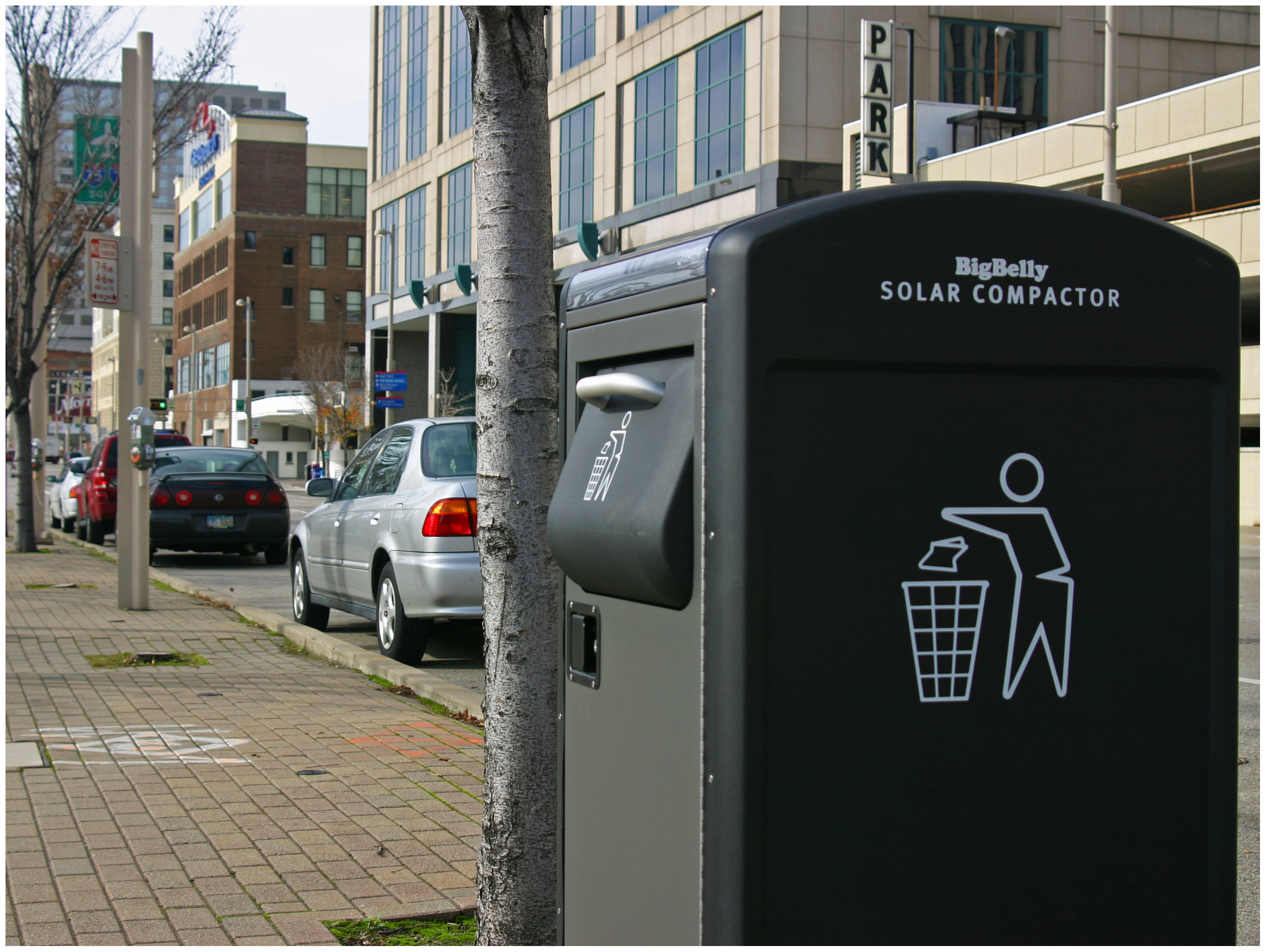
The first sidewalk BigBelly solar cans were installed on Third Street in downtown Cincinnati. Photograph by Randy A. Simes for UrbanCincy.

City officials say that the cans cost approximately $4,500 each, and that the purchases were made using the city’s corner can replacement fund for annual maintenance and replacement of trash cans throughout the city. Old cans being replaced by the new BigBelly solar cans, Whitaker says, are being used as replacements for other existing cans in bad repair throughout the city.

While it is still too early to judge results of the new cans, the idea is that the long-term savings will offset the initial capital cost increase.

“The BigBelly cans have not been installed for very long, but we expect the new cans to cost more in maintenance due to the cost associated with replacing sophisticated components,” Whitaker explained. “The new cans have a lot more moving parts that could malfunction; however, we anticipate the cost of repairs to be offset by savings from less frequent collections.”

Prior to replacing street trash cans, scores of BigBelly trash compactor units had been installed throughout some of the city’s busiest parks including Piatt Park, Eden Park and Lytle Park.

Boston was one of the first cities to aggressively pursue the installation of such trash receptacles in its city. The primary justification was due to the promise of increased efficiency, improved service levels, less frequent collections, the ability to remotely monitor the status of the cans, and more sanitary environment thanks to the closed lid design which prevents water and rodents from getting to the trash and prevents debris from blowing into the street.

Philadelphia has also pursued this change and estimates that replacing 700 standard trash cans with 500 BigBelly units will result in approximately $2,600 in savings per unit over the next ten years.

In Cincinnati officials say that it is likely additional solar-powered trash cans will be converted as funding becomes available, but that the number of cans and their placement has yet to be determined.

“When you think of trash collection most of the energy is spent going out to serve a location,” Office of Environmental Quality director, Larry Falkin, told UrbanCincy. “So if you can service a location less frequently there there’s a quick payback for the technology. It’s really about finding the right location where the efficiencies are worth it, and downtown and park locations seem to make a lot of sense.”

Categories
Business News Politics Transportation

Uptown neighborhoods looking to reform on-street parking policies

The streets of Clifton Heights, University Heights, and Fairview (CUF) are becoming more congested each year. As the University of Cincinnati (UC) enrollment increases, it has become a struggle to provide enough housing units and places to store automobiles.

This growing population shines light on a problem CUF has struggled with for more than 30 years. It is hard not to notice that Cincinnati’s urban core is on the up-and-up, and the work that organizations like the Cincinnati Center City Development Corporation (3CDC) and OTR A.D.O.P.T. are doing in Over-the-Rhine is making the area more attractive to young professionals, artists, students, and even some older suburbanite emigres. And this is a trend that seems poised to continue as gasoline prices continue to rise.


Proposed parking reform plan for uptown’s Clifton Heights, University Heights and Fairview neighborhoods. Image Provided.

The increased interest in downtown will soon spillover into CUF which itself has many benefits – ample green space (Bellevue Hill Park, Fairview Park, and tree-lined streets), a variety of restaurants and nightlife, unique cafes, beautiful houses and of course its proximity to UC, Findlay Market, Over-the-Rhine and the Central Business District. An influx in residents means more people, more cars and tougher competition for car storage in a neighborhood proudly built in an age before automobile parking was mandated by law.

It was with all of this in mind that the CUF Neighborhood Association (CUFNA) trustees formed a committee in the summer of 2010 to develop solutions to the parking problem. The committee, made up of longtime residents, landlords, students, new residents, and business owners, has worked for the past year-and-a-half to develop a plan to serve the parking needs of both residents and visitors alike.

The committee’s proposal is similar to San Francisco’s metered parking program, and calls for a market-based approach to allocating on-street spaces. It is envisioned that this will provide residents with greater certainty in parking while allowing better access for shoppers and visitors. The plan, which would ensure the constant availability of parking spaces, is projected to pay for itself and provide a substantial new source of revenue for either the City or a specific neighborhood improvement district.

The parking proposal calls for the introduction of priced monthly permits or smart-metered shorter term parking for the roughly 3,000 on-street spaces in Clifton Heights, University Heights and Fairview. The city’s Department of Transportation & Engineering (DOTE) would then be responsible for setting permit and meter prices each month to target an 85-90% occupancy rate.

The prices, advocates say, would be skewed in favor of neighborhood residents and would ensure that some spaces are always available when they are needed. Currently, residents and visitors alike can spend up to an hour circling not only on weeknights, but throughout the day as well.

Preliminary numbers indicate the revenue from permit sales alone could pay for around-the-clock enforcement while still generating a surplus of between $50,000 and $200,000 annually. San Francisco and Washington, D.C. have proven the popularity of such programs. With increasingly congested streets these cities began to set market forces on the efficient allocation of on-street vehicular parking.

Advocates of the idea say that they are still working to get the city’s support, but hope that progress can be made on the reforms sometime in 2012.

Categories
Business Development News Opinion Transportation

Cincinnati’s Wasson Railroad Corridor Should Not Be Converted Into Recreational Trail

In the post-industrial United States cities all across America have been left with an abundance of rail right-of-way that once served industrial properties. Cities have since struggled to find a use for these rail corridors.

In many cases the rail right-of-way either gets built over, or makes room for some other use – most typically a park or trail of some sort. The most famous, and perhaps most unique, example of this is New York City’s Highline which converted an abandoned freight rail corridor into an elevated park. In most cities, however, much simpler trails are developed in order to cater to bicyclists and pedestrians.

These are great projects, but in the cases where rail right-of-way is needed in order to introduce rail transit, they should not be done. The acquisition of right-of-way can be one of the most difficult hurdles to clear when developing rail transit, so if you have a prime corridor intact, you should do everything in your power to preserve it for future rail transit.


Map of the proposed Wasson Way Project.

The reason this is particularly important in Cincinnati right now is because on March 6, advocates of what is being called Wasson Way Project will present their ideas for converting the Wasson Corridor into a bike/ped trail to City Council’s Strategic Growth Committee.

The idea is not a bad one on face value, but should it proceed it would eliminate one of the most valuable rail corridors in the city. A corridor that could connect neighborhoods like Hyde Park, Oakley, Evanston, Norwood, Mt. Lookout, Fairfax and Mariemont with light rail and eventually connect those neighborhoods to the region’s two largest employment centers – uptown and downtown – without much additional track or right-of-way acquisition.

“I know of no example in the United States where a former railway that has been converted to a bike/hike trail has ever been returned to passenger rail service,” explained Cincinnati transit advocate John Schneider (aka “Mr. Transit”). “Once it’s gone, it’s gone.”

Rail corridors that run through areas of limited potential transit ridership like the Oasis Line should be redeveloped into trails. It just makes sense. There is less automobile traffic and the riverfront trail provides a scenic ride for bicyclists and connects its users to a string of riverfront parks.

The Wasson Line, however, is ripe for light rail service with its densely populated neighborhood, vibrant business districts and key attractions along the line. The Oasis Line should become a bike/ped trail, but the Wasson Line should not.

Unfortunately the exact opposite is progressing for both of these lines in Cincinnati. Hamilton County officials continue to explore funding options to turn the Oasis Line into a commuter rail corridor, and a citizen-led group is strongly advocating for the conversion of the Wasson Line into a bike/ped trail.

While UrbanCincy supports conversion of some rail right-of-ways into other uses, we believe it needs to be done in a thoughtful manner that considers the future transit needs of the region. The Wasson Line is too valuable to convert into a bike/ped trail and should be preserved for an urban light rail line.

The upcoming committee meeting is scheduled to take place at 12pm on Tuesday, March 6 at City Hall (map). We would like to urge you to come out and support the future of regional light rail in the Cincinnati region, and request that the Wasson Corridor not be converted into a recreational trail.

Categories
Business Development News Politics Transportation

The story behind Cincinnati’s slowly disappearing skywalk system

Over the past few weeks, city crews were busy dismantling another section of downtown Cincinnati’s once extensive skywalk system. The section, an open air walkway over Elm Street and Rusconi Place, was taken down by the city in preparation for the World Choir Games this summer, and the demolition is the latest phase of an ongoing effort to dismantle the city’s once expansive skywalk system.

Developed in the 1960’s as a way for downtown retailers to compete with the enclosed shopping environments found in suburban malls, the city implemented an ambitious plan to construct a series of elevated walkways extending from Fourth and Broadway northwest to the Duke Energy Convention Center.

The skywalks became the preferred connection to places along the route including Fountain Square; Tower Place Mall; department stores such as Shilito’s, Pogue’s, McAlpin’s and LS Ayers; as well as corporate office buildings; Riverfront Stadium; the convention center and its adjoining parking garages.

By the early 2000’s, the skywalk system was stymied by poor way-finding and aggressive pan-handling, and several sections had fallen into disrepair. The system was difficult to control and maintain due to ownership issues surrounding the elevated walkways. But to many urban planners, the biggest issue was that the skywalk system discouraged street-level foot traffic.

Removal and reconfiguration of the skywalk system was proposed as part of the 2002 Center City Plan. The plan found that downtown Cincinnati was declining due to loss of economic activity to the city’s suburbs, and it emphasized the development of places in downtown that highlighted the urban core’s built assets.

Skywalks, the report said, allowed pedestrians to bypass the street which contributed to the perception that downtown was abandoned. To counter those perceptions, the report called for expanding street-level pedestrian activity while also programming pedestrian activity on the street to create economic vibrancy.

“The way you help to build a vital center is to put people on the streets and to enable them to have connectivity on these streets,” city spokesperson Meg Olberding told UrbanCincy.

The city’s actions were even profiled by the New York Times in a 2005 story entitled Rethinking Skyways and Tunnels.

“And now, as cities try to draw residents downtown with loft conversions and tax incentives, several are trying to divert pedestrians back to the street and do away with the walkways.” Patrick O’Gilfoil Healy wrote. “Critics say the walkways are too antiseptic and too controlled and have transformed cities into places to pass through, not live in.”

The skywalk began to come down with the reconfiguration of Fort Washington Way. A piece connecting Riverfront Stadium to the Atrium I and II office towers was demolished in 2002, with other pieces following thereafter. In 2005, the city demolished two sections of the skywalk from the 5/3 Tower to Vine Street and the pedestrian bridge over Fifth Street as part of the $49 million redevelopment of Fountain Square. A second segment that connected Saks Fifth Avenue to the site of a former office tower at Fifth and Race was then dismantled in 2007, and other older sections of the skywalk are likely to be removed in the near future.

Although a considerable amount of the system is still intact today, the biggest improvement from the dismantling thus far can be seen at Fountain Square. Prior to its removal, the Vine Street Skywalk was the busiest skywalk in the city carrying thousands of pedestrians over many street level storefronts and street vendors. The removal of this skywalk helped create today’s vibrant Fountains Square, which is a testament to this policy shift.

As for future plans for the remaining segments of the skywalk, City officials have informed UrbanCincy that the skywalk connecting to Macy’s over Race Street will likely not be utilized in the upcoming dunnhumbyUSA development at Fifth and Race. Oldberding also disclosed that future skywalk demolitions will be decided on a case-by-case basis saying, “We look at how they are contributing to the vitality of the urban center.”

As the skywalk is slowly removed, we have found it necessary to chronicle the once enormous reach of the declining system. UrbanCincy’s research team has developed a map charting the demolished and remaining sections of the skywalk system, as well as the one possible expansion at Great American Tower at Queen City Square. As new sections come down, the map will be updated to reflect those changes.

Categories
Business Development News Politics Transportation

Hundreds of Cincinnatians celebrate groundbreaking of Midwest’s first modern streetcar

On what turned out to be virtually perfect weather for Cincinnati in mid-February, hundreds of people gathered to celebrate the official groundbreaking of the Cincinnati Streetcar this past Friday.

The event was announced to the public a week prior, and included dignitaries and media from not only Cincinnati but from around the United States. The #LetsGo stream used on Twitter quickly became a trending topic and people from St. Louis, Portland, Washington D.C., Atlanta, Chicago, Milwaukee, Seattle, Cleveland and Indianapolis chimed in with their praise of Cincinnati.

Some of the dignitaries at the event included FTA Administrator Peter Rogoff; Cincinnati Mayor Mark Mallory (D); City Manager Milton Dohoney; councilmembers Laure Quinlivan (D), Roxanne Qualls (C), Chris Seelbach (D), Yvette Simpson (D), Wendal Young (D), Cecil Thomas (D); and Secretary of Trasnportation Ray LaHood (R).

Those in Cincinnati who have been involved with its efforts to improve its transit system know that the most honored guest of the day was John Schneider. Schneider, or as Mayor Mallory refered to him “Mr. Streetcar,” has been advocating regional transit improvements for nearly two decades and has taken scores of Cincinnatians to Portland to see how modern streetcars work first-hand.

Schneider also serves on the Cincinnati Planning Commission and has been living car-free in Cincinnati for many years. During the press conference Mayor Mallory gave the podium over to Mr. Schneider so that he could share his thoughts on the historic day.

UrbanCincy contributor Jake Mecklenborg also captured the climatic end to the event as the hundreds in attendance counted down to the official groundbreaking.