Categories
Arts & Entertainment Development Transportation

New time-lapse video captures movement of people and machines in Cincinnati

Friend of UrbanCincy and regular URBANexchange attendee, Andrew Stahlke, has produced a new time-lapse video of Cincinnati.

The video showcases construction work at the $400 million Horseshoe Casino, Little Miami Scenic Trail, Eden Park Overlook, boats on the Ohio River, circus training at Burnett Woods, freight activity at the Queensgate Railyards, construction of the new $66.5 million Waldvogel Viaduct, fans at Great American Ball Park, and many other scenes from around Cincinnati.

Stahlke is currently enrolled in the Masters of Community Planning program at the University of Cincinnati, and originally studied civil engineering at Case Western University.

The video, entitled Paths and Nodes: Cincinnati, attempts to capture the life of the city as people and machines move about, and was shot in early fall 2012. It is a nearly three minutes in length, and features music from Little People.

Categories
Development News Opinion Politics

What’s the full story behind Cincinnati’s 50-year population decline?

Cincinnati, like all peer cities, recorded its peak population in the 1950 and has steadily lost residents since. Specifically, Cincinnati has lost 205,000, or 43 percent of its peak population of 503,998 as recorded by the U.S. Census Bureau. Meanwhile, the population of Cincinnati’s metropolitan statistical area has doubled to 2.2 million.

Contrary to the narrative perpetuated by those who practice the politics of decline, this loss of population is symptomatic not of variously corrupt or negligent city officials but is rather the outcome of social trends that have evolved well outside the purview of city government. What’s more, nationwide demographic trends and elevated living standards mean attracting 205,000 new residents would require the City of Cincinnati to transform itself physically into something entirely unlike what it is at present or was in 1950.


Cincinnati’s population has taken a recent downward trajectory, but there may be more to the story. Chart produced by UrbanCincy.

Demographic Changes since 1950
Entirely overlooked in the public discussion of city population decline is the end of the postwar “Baby Boom” which was enabled by the U.S. Food & Drug Administration’s (FDA) approval of oral contraceptives in 1960, and the U.S. Supreme Court’s legalization of abortion in 1973. Between 1960 and 1975, the number of annual live births in the United States fell from 4.25 million to 3.1 million.

An academic assessment of how the plummeting birthrate affected Cincinnati’s population could consume weeks of research. But the drop in family size, along with the proliferation of separations and divorces, means nearly all Cincinnati homes and apartment units that were occupied by large families in the 1950s are today occupied by fewer people.

So for Cincinnati to regain its lost 205,000 residents, the number of people residing in existing homes and apartment units must increase dramatically, and new construction must be populated at something higher than today’s prevailing density. With no reason to expect that Cincinnati’s birthrate will suddenly increase to that of impoverished countries, all population growth must come from the city’s suburbs or from outside the region. The wealthier the newcomer, the more living space they can afford. So paradoxically, the successful pursuit of top talent frustrates the task of fitting 205,000 new residents within Cincinnati’s existing city limits.

Loss of Residential Neighborhoods
Cincinnati’s municipal boundaries have not changed since it achieved its peak population in 1950, but thousands of prewar homes and apartments have since been replaced by non-residential structures. This means Cincinnati not only lost tens of thousands of residents for construction of expressways, light industry, and other purposes, but these properties are generally unavailable today for any effort to repopulate the city.

Cincinnati’s loss of residents and residential land was not limited to expressway construction and urban renewal projects. In the neighborhoods collectively known as Uptown, physical growth of universities, hospitals and other institutions has resulted in the demolition of over 1,000 homes and apartments since 1950.


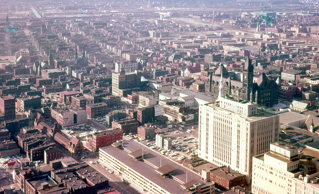
The West End, shown here in 1959, was demolished shortly after from 1960 and 1963 for Interstate 75 and the Queensgate industrial park. Photograph by Dave Tunison.

The Politics of Population Decline
A variety of unscrupulous local politicians and media figures cleverly play two sides of Cincinnati’s population loss narrative. According to them, Cincinnati has lost population due to high crime, high taxes, and corrupt city governance. But should the city start attracting new residents, the perceived “bad element” will be pushed outside city limits and into the areas of those trumpeting this false narrative.

Therefore, with every avuncular call for Cincinnati to improve itself, these figures work to undermine the city’s capital improvements, and have succeeded in creating a suburban culture that looks upon the city and those who support it with deep suspicion. What’s more, those who play the politics of decline know that Cincinnati cannot physically house 205,000 more residents without construction of dozens of hi-rise apartment blocks. Such apartment clusters and the subway system necessary to move their residents throughout the city would be met with excited accusations of “communism”.

Certainly, Cincinnati would benefit from new residents, especially in its under-populated neighborhoods where many historic structures are at risk of demolition. The arrival of 205,000 residents within the city limits would resolve many of the city’s current problems but would force higher apartment rents, increase noise and traffic congestion, and would motivate the demolition of historic structures for new multistory apartments and commercial buildings.

So while virtually every old American city has lost population within its city limits since 1950, some of that loss has occurred for reasons unrelated to the commonly heard decline narrative. Family sizes are smaller, non-residential buildings have been built in some former residential areas, and new neighborhoods have formed outside city limits to house those displaced by commercial and institutional growth. Considering these realities, the City of Cincinnati will likely never again be the home of 504,000 people, and so should not measure itself against its former peak population.


Categories
Business Development News Opinion Transportation

Reimagined Brent Spence Bridge alignment could prove to be financial windfall for Cincinnati

On Tuesday April 24 and Wednesday April 25 residents will have a chance to voice their concerns about the preferred Brent Spence Bridge design alternative, currently known as Alternative I at Longworth Hall. The proposal would build a new bridge adjacent to the existing Brent Spence Bridge.

The process, which began in 2004, has a nebulous future ahead of it with uncertainty pertaining to future funding from a new federal transportation bill. Recently, state officials have said that parts of the overall rebuild of I-75 through Cincinnati may be delayed for up to fifteen years. The new funding paradigm has left local leaders on both sides of the river talking about public-private partnerships. Because of this uncertain future, it may be possible to reexamine one of the bridge options not pursued.


More than two dozen new city blocks would be able to generate in excess of $200 million annually in property tax revenue alone, should the new Brent Spence Bridge be shifted west. Rendering from Revive I-75 Study.

In 2010, the City of Cincinnati hired consultants to conduct several workgroups along the Interstate 75 corridor within the city limits. The study, named Revive I-75, addressed ways to mitigate the impact of the expanded highway on the surrounding urban neighborhoods. What also came out of the study was a visualization of the possible configuration of a new bridge for I-75 on the opposite side of Longworth Hall that would have allowed for the expansion of the Central Business District.

At the time there were several alignment configurations under study that would have moved the new bridge west of Longworth Hall, shrinking the amount of land the spaghetti-like on ramps use to connect I-71 to I-75 and the bridge. These alternatives were embodied in Alternatives A & B in the Brent Spence Bridge Corridor study. Yet both alternatives were removed from consideration citing environmental impacts and cost concerns. One of the arguments raised in opposition to the proposal was that that the city would lose valuable tax revenue from the affected industrial businesses in Queensgate.

However; according to urban economists such as Joe Minicozzi and Peter Katz, multi-story mixed use development actually brings in the most tax revenue for local jurisdictions when compared to single use facilities. In their study on Sarasota, Florida, it was found that a local mall generated only $22,000 in tax revenue per acre whereas a 17-story mixed use tower generated $1.01 million in tax revenue per acre. Since the 2010 study, Minicozzi has performed the same study in over fifteen different municipalities with similar results.

In a recent article written by Emily Badger, she summarizes several pertinent studies and surmises that, “We tend to think that broke cities have two options: raise taxes, or cut services. Minicozzi, though, is trying to point to the basic but long-buried math of our tax system that cities should be exploiting instead: Per-acre, our downtowns have the potential to generate so much more public wealth than low-density subdivisions or massive malls by the highway. And for all that revenue they bring in, downtowns cost considerably less to maintain in public services and infrastructure.”


Shifting the new Brent Spence Bridge to the west would allow downtown Cincinnati to be relieved from the existing and proposed entanglement of highway ramps. Rendering from Revive I-75 study.

A land use analysis performed by the UrbanCincy team found that the alternatives presented and illustrated in the Revive-75 documents would increase the amount of new land available in the Central Business District by roughly 33 percent. Approximately 25 new city blocks would be created under the proposal, freeing up land that is currently taken up by the expansive tangle of roadways that connect I-75, I-71 and the Brent Spence Bridge.

This would be accomplished by maintaining the ramps that connect I-71 to the Brent Spence Bridge and extending Fort Washington Way west, becoming the Third Street Expressway. This expressway will later align with the Sixth Street Expressway after connecting to the new bridge alignment west of Longworth Hall. The street grid would then be reestablished and developable real estate could be maximized on the newly reclaimed land. Based on the research provided from Minicozzi and Katz, UrbanCincy estimates that the taxable revenue capture could be more than $200 million from property taxes alone.

Such a move would not only allow for a sizable expansion of the Central Business District, but it would also create available land for a future expansion of the Duke Energy Convention Center. In a time when public agencies are trying to do more with less, this is a perfect opportunity to create more tax-productive property in the heart of the Cincinnati region. Moving the new bridge west is a solution that city, county and local business leaders should all support.

Categories
Business Development News Transportation

Massive funding cuts at ODOT pose threat for Cincinnati-area projects

The tentative project list released last week by the Ohio Department of Transportation’s (ODOT) Transportation Review Advisory Committee (TRAC) will delay many major highway construction projects throughout the Cincinnati region.

Some of the Cincinnati-area projects to be impacted by ODOT’s budget crisis include the Oasis commuter rail line which had its funding erased, the highway portion of the Eastern Corridor Project which has now been delayed, and start dates on future phases of I-75 reconstruction work have been pushed beyond 2020.

ODOT’s cuts have also affected the City of Cincinnati’s West MLK Drive Access Improvement, since that project was coordinated with phase four of the I-75 Millcreek Expressway project. Some of that prep work has begun with ODOT demolishing the old Interstate Motel and several apartment buildings near McMicken Street in 2011 in preparation for reconstruction of the Hopple Street interchange in 2013.


Martin Luther King Drive works its way uptown [LEFT]. An aerial view of the Hopple Street Interchange [RIGHT]. Photographs by Jake Mecklenborg for UrbanCincy.

With $109 million in Millcreek Expressway phase four funds now delayed until after 2020, Michael Moore, Director of the Department of Transportation & Engineering (DOTE), told UrbanCincy that the city will continue to proceed with work planned for MLK Drive between Dixmyth Avenue and McMicken Street in 2012.

“We will have to modify the west end of the project, since our design ties into the ODOT work,” explained Moore. “Then ODOT will have to modify their eastern end to tie into our work. At issue will be how the shared bike/hike path terminates, but there is really little that can be done at this time with our project to connect to Central Parkway without the reconstruction of the Hopple Street bridge.”

Two miles east of the West MLK Drive Access Improvement, preliminary planning will continue for an interchange between East MLK and I-71. TRAC has programmed $3 million to fund environmental studies, select a preferred alternative, and perform preliminary design work.


Construction work progresses on the Waldvogel Viaduct in Lower Price Hill. Photograph by Jake Mecklenborg for UrbanCincy.

“No timetable had been set for construction, since this preliminary work had not been funded, but this TRAC infusion is good news and allows us to move ahead to prepare plans,” Moore detailed. “ODOT is also working out a plan of action for changing this project to the new Plan Development Process. This should help streamline the project development a bit.”

Elsewhere, phase one reconstruction work on I-75 will continue near Mitchell Avenue, and work on phase three, the reconstruction of the I-74 Beekman/Colerain interchange, has been fully funded and will commence later this year. However, funding for reconstruction of the I-75/I-74 interchange and all work south of that point has been delayed, as has all planned work between the Norwood Lateral and I-275.

When asked about the ongoing work on the Waldvogel Viaduct, DOTE’s director informed UrbanCincy that the reconstruction project has been fully funded, and will not be affected by ODOT’s cuts. A second phase of that project, which involves upgrades to the Sixth Street Expressway, has also been fully funded and will proceed as planned.

Download a PDF of TRAC’s entire project list.

Categories
Business News

Cincinnati Railroad Club to digitize, preserve 70,000-item library collection

An effort to digitize the 70,000-item collection of the Cincinnati Railroad Club’s library is currently underway. Known as the Cincinnati Rail History Preservation Project, the three-year undertaking will for the first time organize the materials acquired by the library since the club’s founding in 1938.

Ari Buchwald, who is directing the project through Edgecliff Press, is assisting the club in its intent for most non-copyrighted materials to be made available online, including geomapping of the library’s thousands of original photographs. He believes that the digitized library will be of interest to the general public, not just railroad enthusiasts, due to the overlap of many of its materials with other interests. For those doing genealogical research, Buchwald says that digitization will enable quick searches of employee records and that facial recognition software will locate photographs of deceased relatives.

According to club member Roy Hord, the collection grew substantially in size and eclecticism after dumpster-diving efforts recovered items from the 1972 demolition of Union Terminal’s passenger concourse. A second salvage project – the recovery of materials from the old B&O warehouse (now Longworth Hall) – fills an entire room of the library’s off-site storage space.

Much storage space is also dedicated to hundreds of blueprints dating from the construction of Union Terminal and other area rail projects. Digitization of blueprints and other large items is being handled by Robin Imaging, one of the Rail Preservation Project’s in-kind partners.

Buchwald expects that the digitization will permit the club to earn royalties from the licensing of specific items and that it will greatly facilitate the task of publishing new books (the club has published three books to date, including Cincinnati Union Terminal: Design and Construction of an Art Deco Masterpiece). These future returns are not sufficient to finance the digitization, and so Buchwald is leading a $1 million fundraising campaign that will determine the project’s eventual completion, and enable him to hire a full-time staff.

Ari Buchwald photograph by Jake Mecklenborg for UrbanCincy.