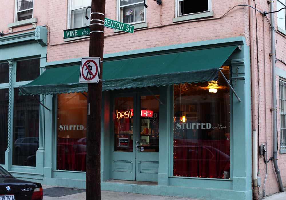
Michael Daniels and Charlena Calloway have a brand new burger for Cincinnatians to try. The husband and wife duo officially opened their new restaurant, Stuffed on Vine, on March 1. Located in Over-the-Rhine, just a block east of Findlay Market and a few doors north of Tuckers, OTR’s newest eatery seeks to offer affordable food with a homey feel.
Daniels and Calloway both grew up in Cincinnati, but had been living in Atlanta for the past 13 years. The couple moved back home to be closer to family, and job circumstances led to the new venture.
“I developed my Stuffed Burger down in Atlanta, and had been selling them along with home made barbeque on weekends,” Charlena explained. “I’ve always loved cooking for friends and family, and it just made sense to try having our own place.”
Though the actual patty construction is a secret, the signature Big Lene burger boasts a combination of mushrooms, onion, bell peppers, hot sport peppers, four cheeses and mayonnaise tucked inside a generous portion of ground beef. With the exception of a poor rendition from Burger King, Lena’s creation is extremely unique to the area.
“Every bite of the burger is a different flavor experience,” said Calloway. “You’re not allowed to cut into the burger – if you ask for a knife, I’ll say not until you take a bite first!”
Other menu items include wings with a wide array of sauces, made-fresh-daily in house chili, tilapia salad, a variety of sandwiches and a killer take on the Cincinnati coney (according to this writer). The coney is a kosher beef dog with the special chili containing tomatoes, bell peppers, ground beef and a slightly spicy kick. There are weekly specials, and on Sundays folks can stop by for a traditional dinner – $8 buys one meat, three sides, and a bread – for a real Southern style treat.
The owners have signed a one-year lease on the 4,000-square-foot space that was once home to Stenger’s Cafe. The couple has worked to refine the interior – the original bar and counter have been refinished, and the tin ceiling remains in stellar condition. There are small tables along the side wall, classic black and white tile on the floor, and a big screen television near the back of the space for friends to gather to watch sports games over food.
As Michael and Charlena get settled in to their new business in the heart of Over-the-Rhine, they are also excited about the changes that have occured in the historic neighborhood they left in 1998.
“It’s really great, what they’ve done on Vine Street,” said Daniels. “These kids around here are saying, ‘How do you know? You’re not from here!’ but we grew up right around the corner. We remember how it used to be. It’s amazing how quickly the development is moving north. I guess you don’t see it when it’s happening right before your eyes.”
At the end of the day, the duo wants to have a comfortable, reasonably priced community spot where customers will walk away completely satisfied. “It’s like I always say,” Charlena said with a smile, “when the burgers are stuffed, you are too!”
Stuffed on Vine is located at 1720 Vine Street in Over-the-Rhine. The restaurant is open Tuesday through Thursday 11am to 9pm, Fridays and Saturdays 11am to 11pm, and Sundays from 1pm to 8pm. Stuffed on Vine is cash only, and patrons are asked to call ahead for the Sunday menu at (513) 338-7657.
Stuffed on Vine photograph by UrbanCincy contributor Jake Mecklenborg.
One-by-one, and with little fanfare, nearly every major American city which scrapped its streetcar and other rail transit lines mid-century has since 1970 built a new rail system of some kind. Between 1970 and 1990, new-start systems began operations in Washington, DC, Baltimore, San Francisco, Los Angeles, Portland, Atlanta, Buffalo, San Diego and Miami. Between 1990 and 2010, new-start systems were built in Denver, St. Louis, Seattle, Sacramento, Dallas, Houston, Charlotte, Salt Lake City, Minneapolis and Phoenix.
As of 2011, Cincinnati is now the largest metropolitan area, with the exception of Detroit, with no rail transit whatsoever. Attempts to fund a regional rail transit system were defeated by Hamilton County voters in 1971, 1979, 1980, and 2002. Cincinnati’s modern streetcar plan, after winning at the polls in 2009, was fully funded in 2010 but faces yet another challenge from special interest groups in 2011.
Is there some physical reason why rail transit is poorly suited for Cincinnati, as its opponents have always contended? No – and the purpose of this article is to illustrate that Cincinnati is in fact much better suited than several cities that have recently built rail transit systems. In short, dating from Mayor Murray Seasongood’s assertion in the late 1920’s that Cincinnati was too small for a rapid transit system, a long line of Cincinnati politicians, usually self-proclaimed reformers or financial watchdogs have succeeded in diverting federal funds away from Cincinnati to less deserving cities.
How Atlanta received the Federal award to build MARTA Thirteen years after passage of Federal-Aid Highway Act of 1956, the Federal Government began funding construction of rapid transit systems. First was the Washington Metro, which received funding in 1969 and began construction shortly thereafter. The Urban Mass Transit Act of 1970 allocated $10 billion for the expansion and upkeep of existing systems in New York, Boston, Philadelphia, Chicago, and elsewhere, and funded approximately 80 percent of the cost of new rapid transit systems in Baltimore, Miami and Atlanta.
The award of nearly $1 billion, to Atlanta in the early 1970’s, stands as one of the most bizarre episodes in the history of public transportation in the United States. This enormous sum (equivalent to approximately $3 billion in 2011 dollars) was originally allocated to Seattle but was diverted after King County voters failed to approve a local tax to operate the planned system. Meanwhile, Atlanta-area voters did approve a transit sales tax, and due to a shortage of cities with such a tax, received the federal award and broke ground on MARTA in 1975.
The configuration of MARTA’s two lines, which radiate from downtown Atlanta in four directions, has been the subject of much criticism. Approximately four miles of subway construction in the Downtown and Midtown areas consumed enough of the project’s budget as to force cut backs in suburban areas. Outside of the Downtown tunnels, the lines typically follow freight rail lines, with inconveniently positioned stations. These poorly located stations have limited the system’s overall ridership by discouraging the construction of transit-oriented developments. Nevertheless, large transit-oriented developments (TODs) have been built at some MARTA stations, and system ridership is presently reported to be 260,000 each weekday.
So why did Cincinnati not apply for the award Atlanta received?
In 1970, Atlanta and Cincinnati were at the center of metropolitan statistical areas (MSA) identical in population. But Cincinnati was still much more densely built than Atlanta, and therefore much better suited for construction of a rapid transit system. Not only were Downtown and Over-the-Rhine much more active than they are now, but Cincinnati had numerous old neighborhood business districts that could have been saved from extinction with a subway station beneath their primary intersections.
A drawing for such a system was in fact made by the Ohio-Kentucky-Indiana Regional Council of Governments (OKI). In anticipation of a UMTA application in 1971, OKI developed a 57-mile regional rapid transit plan that would have included at least 10 miles of subway construction in Cincinnati, a tunnel under the Ohio River, and more subway construction in Covington and Newport. Under UMTA guidelines, Cincinnati-area residents would only pay $100 million of its estimated $500 million capital cost.
But Cincinnati could not apply because UMTA awards were available only for those cities with publicly operated bus companies. In 1970 public transportation in Cincinnati was still provided by Cincinnati Transit, the bus-only descendant of the Cincinnati Street Railway, a situation that persisted after a countywide property tax that would have funded a public bus company failed in 1971. Cincinnati Transit was not put out of its misery until city voters approved an earnings tax in 1973 that enabled formation of Queen City Metro.
The .03 percent earnings tax was insufficient to cover the 20 percent local match required for UMTA awards, therefore, even after having established a public bus company, Cincinnati could still not apply for large capital awards without either a supplement or replacement of the city earnings tax. A pair of countywide transit taxes failed in 1979 and 1980, and therefore Cincinnatians paid in but received nothing from the Urban Mass Transit Assistance Act.
What is so frustrating about these events is that of the three cities that received new-start awards, only the traditional urban character of Baltimore in any way resembles that of Cincinnati. Miami and Atlanta, which by 1970 had just surpassed Cincinnati in size, experienced most of their growth in the automobile era and so could not possibly benefit similarly from construction of rapid transit systems. In short, federal awards weren’t made on the basis of suitability or cost-benefit, but rather who fought hardest for the money.
What if…? Federal funding of rail transit declined after the exhaustion of UMTA funds in the late 1970’s. As such, the FTA has not funded any new-start rapid transit subway systems, with the exception of the Los Angeles Red and Purple Lines in the late 1980’s, and has shifted its funding to the less expensive light rail mode. In Cincinnati, regional transit system plans downsized from OKI’s 1971 Regional Rapid Transit plan to less ambitious light rail plans.
These light rail plans typically called for little or no tunnel construction. Unfortunately, this is not the best solution for Cincinnati, as many of its walkable neighborhood business districts can only be reached by the type of bored tunnels called for in OKI’s 1971 Regional Rapid Transit Plan. Since the FTA no longer funds extensive tunnel construction in mid-sized cities, Cincinnati has no hope of constructing such tunnels without a return of Federal funding for such projects to 1970’s levels.
Next time you are in Hyde Park Square, at Skyline Chili in Clifton, near St. Lawrence Church in Price Hill, or walking Covington’s MainStrasse Village, imagine being able to walk down a staircase to a subway train that could take you Downtown or to any of those other points in just a few minutes. The money was there for the taking back in the early 1970’s, and we could have gotten it just as easily as Atlanta did, but your parents and grandparents were tricked into voting against it.
Jake Mecklenborg is a transit historian and published author. His new book Cincinnati’s Incomplete Subway: The Complete History explores the strange and largely untold history of rail transit in the Queen City.
First instinct may tell us that widening a congested highway will help reduce traffic congestion, but the reality is quite different. Highway widening projects not only create additional congestion during the construction work, but also increase the highways usage once work is complete thus contributing to the cycle of congestion.
Cincinnatians are soon to experience what may be the most tumultuous highway construction period ever. Interstate 75 will be reconstructed and widened roughly from the Norwood Lateral to the Ohio River including the Brent Spence Bridge and its approaches. This construction work will cost billions of dollars and create a decade-long nightmare for Cincinnatians with no other commuting options than their automobile.
Unfortunately the “no pain, no gain” saying doesn’t fit here, as the OKI Regional Council of Governments has previously studied and determined that the reconstruction effort will bring I-75 from a Class D level highway to a, wait for it, Class D level highway once it is complete.
There are two primary reasons for this: 1) the work being planned now will take more than a decade to complete and by that point traffic demands will increase and call for additional capacity not being anticipated now, and 2) the completed improvements will encourage additional drivers to take the heavily traveled corridor instead of taking what may be less direct side routes. The second factor is often experienced in its inverse when people take less direct routes to avoid what may be perceived as a more cumbersome route due to congestion or tolling for example.
In 1942 Robert Moses noticed that the highways he had built around New York City in 1939 were somehow generating greater traffic problems than had existed previously. Since then, the phenomenon has been well documented, most notably in 1989, when the Southern California Association of Governments concluded that traffic-assistance measures, be they adding lanes, or even double-decking the roadways, would have no more than a cosmetic effect on Los Angeles’ traffic problems. -Andres Duany in Suburban Nation
Cincinnatians should learn from Atlanta where they have mastered the art of expanding highways to unbelievable measures. The infamous “Connector” running through Midtown and Downtown Atlanta carries both I-75 and I-85 traffic and currently has 14 lanes of moving traffic which is being widened to include an intricate system of parallel roadways and ramps that bloat the stretch of highway to some 20 or so lanes.
The “Connector” through Midtown Atlanta as it approaches Downtown on a typical evening commute.
But even with the large vehicle capacity, through truck ban, HOV lanes, and parallel roads the highway is still a congested mess each rush hour and often throughout much of the day (including weekends). The problem in Atlanta is that their rail system, MARTA, does not run along either the I-75 or I-85 densely populated and traveled corridors.
When planning for the reconstruction of I-75 through Cincinnati, community leaders need to think beyond the asphalt and realize that additional transportation modes are what will ultimately reduce congestion along the I-75 corridor. Light rail right-of-way is reportedly being planned for in the redesigns and needs to be a serious priority of the effort. It would be short-sighted and misguided to attempt to ease congestion by only addressing one mode of transportation.
As Cincinnati painstakingly works its way towards a more comprehensive transit network we must not forget that American cities are largely built around the automobile and sometimes having access to an automobile makes life easier. This does not mean that you must own and maintain a personal automobile though.
The option for those looking to live car-free or at least car-light is urban car sharing which has taken off in several American cities. In a nutshell urban car sharing compliments lifestyles that use public transit, walking and/or cycling as a primary means of transportation. In these cases the car sharing then acts as an option for trips otherwise not possible through the aforementioned means of transportation.
Out-of-town trips, special occasions (i.e. moving, joy ride, date), or trips to locations accessible only by automobiles are then made easily accessible for those not interesting in owning and maintaining a costly automobile. Users of car sharing programs like Zipcars have been found to reduce the number of automobiles per household and increase their usage of transit, bicycling and walking.
Programs such as these are often popular in high density urban locations well-served by public transit or near places with low car ownership rates like college campuses. In Midtown Atlanta alone there are 21 Zipcar locations that serve the high density urban community which is also home to the Georgia Institute of Technology and its 20,000 students. Comparatively, Uptown Cincinnati has zero Zipcar locations to serve its high density urban community and the University of Cincinnati’s roughly 40,000 students.
If you look further to downtown Atlanta you can add in another seven Zipcar locations with two more in the Inman Park/Little Five Points area just a stones throw away. In downtown Cincinnati and historic Over-the-Rhine the trend continues with zero Zipcar locations serving a higher density urban community than its Atlanta counterpart.
In the rest of Atlanta another 14 Zipcar locations can be found bringing the total to 44 Zipcar locations in Metro Atlanta with one to two cars per location while Cincinnati has none. Meanwhile in Cincinnati car-free individuals struggle to make things work in a limited-bus and car only city with many more looking to have the option of living car-free or car-light.
The number of American cities that boast public transit systems comprehensive enough to allow for mainstream car-free lifestyles can be counted on one hand. As a result car sharing programs like Zipcars play an instrumental role in the process of creating a lesser demand for personal automobiles. And it seems to me like Cincinnati is a perfect urban region for such a program, and regional leaders in Cincinnati should examine establishing a local carsharing program as has been done in cities like Philadelphia and Cleveland.
When one thinks of sprawl the first thought that comes to mind is the spread out, low-density suburbs that have eaten away at our nation’s fertile farmland and natural environment. An immediate reaction is that density is in fact better, but is this so?
There is an assumption made that density would somehow reduce the amount of land needed for sprawling suburbs, and that greater amounts of land can be preserved. This is true in theory, but does not always happen once the market has its way. Furthermore, preserved land is not the same land it once was; meaning that the preserved “greenway” connecting your neighborhood to another community feature may or may not be beneficial to the natural systems that exist. Does it serve as a corridor for wildlife, is it farmable or is the preserved land serving any significant purpose outside of additional trees that are reducing the amount of CO2 in our atmosphere? Most likely not.
What has happened in Atlanta is something that should be learned from. Atlanta is arguably the king of sprawl in modern day America, but some might say, well Fulton County has a higher population density than does Hamilton County. Similar arguments can be applied to other less urban regions than Cincinnati. The fact is that Fulton County is just about built out with the exception of some land in the far southern reaches of the county. Furthermore, this built-out county has extraordinarily dense suburban areas including the central Perimeter area which includes 30 story office towers, residential towers and 12 lane highway systems to boot. The traffic is abysmal like much of the rest of Atlanta and the problem is only going to get worse.
Midtown, Buckhead and Perimeter skylines in Atlanta – photo from mattsal88 on ImageShack
The reason is a combination of densities and form. The suburban areas of Atlanta, and even much of the urban areas, are almost entirely car-dependent. So a low-density suburban area that is car-dependent is one thing, but a high-density area of the same makeup is nightmarish. The “spatial mismatch” is exacerbated to a degree seen nowhere else in America than Atlanta and Los Angeles (Los Angeles County is the most populated county in the country at 9+ million). The people living in one area are working in another creating a spatial mismatch that is exacerbated by the high densities. They are not walking, biking or taking transit to a level enough that would offset its densities.
When you hear of the next “new urbanist” neighborhood on the fringes of a metropolitan area, or the next lifestyle center that pitches itself as being the next best thing to an authentic urban shopping experience, be wary. These are not real communities where store owners live in addition to running their business. The residents are most likely hopping in their car that is parked nicely within one of their two (or more) dedicated parking spaces and driving into the center city for work.
Higher densities in our suburban areas are not the answers to our sprawl issues. A correction of the spatial mismatch is what’s needed to truly create a sustainable metropolitan area. Natural systems need to be preserved in their truest form and our most fertile food-producing regions need to be maintained for their highest and best use. Higher densities in the core with high density satellite neighborhoods connected by high-quality transit options are the best possible solutions.