Categories
Development News Politics Transportation

Cutting through the clutter to get urbanism news

It was approximately one year ago when UrbanCincy dove into the world of Twitter.  We were not sure what to make of it or how to use it, but there is certainly lots of information to be had if you are able to cut through the clutter (if in fact you dislike the clutter).

As a result, UrbanCincy has been putting together a list of those Twitter users who share information and ideas about urbanist issues.  Some focus on transit, some on particular cities or regions, others on policy and others sharing their urban experiences.  The people behind these accounts include policy makers, industry professionals, residents, businesses and writers.

The value is that at any given time you can keep tabs on the heartbeat of urbanism across America, and beyond, by simply following this list of people.  You do not have to be on Twitter to follow the list, but if you want to engage in conversation you do.  In either case the information is there for the taking.  Bookmark the page to follow along at your leisure, or follow the list on Twitter if you have an account.

If you have any other Twitter users that you believe should be added to this list, please leave a comment below so that they can be added to the stream.

Categories
Development News Politics

Cincinnati’s hillsides present unique development opportunity

The beautiful Greek islands throughout the Aegean Sea are often known for their stunning landscapes, crystal clear blue water and their ancient development patterns often dating back to the Bronze Age between 3000-2000 BC. These ancient development patterns, while picturesque, also offer contemporary lessons on how to approach development in space-constrained locations.

In America, the problem is not limited land as experienced on the Greek islands, but rather, it is limited urban real estate. This dilemma often sends buildings and prices higher, with the most easily developed land to go first. Consequently, development often sprawls outward before communities fully maximize development possibilities within their urban centers.

In Cincinnati this scenario is most profound with the city’s hillsides. Early settlers built their homes, businesses and industry along the Ohio River for transportation reasons, and throughout “the basin” in order to take advantage of relatively flat and developable land. Over time Cincinnatians became more mobile and moved up on top of the hills developing areas like Price Hill, the Uptown neighborhoods, Mt. Lookout, Hyde Park and even Mt. Adams. Since then development has shifted even further out to more contemporary suburbs and exurban communities now gobbling up precious farm land in all directions. In the mean time, Cincinnati’s many hillsides have been largely ignored and allowed to either be over- or under-developed.

According to The Hillside Trust, 15 square miles, or 18%, of Cincinnati’s total land area is hillsides. Of the nearly 265,000 acres of land in Hamilton County approximately 60,043 acres, or 23%, consist of hillsides with similar percentages found in Northern Kentucky’s three primary counties – Campbell, Kenton and Boone.

On the Greek islands the exact opposite approach was taken after early Bronze Age settlers developed their communities. Those inhabitants quickly realized that they had to preserve their limited amount of tillable land, and as a result shifted their settlement patterns to the hillsides so that the other, more productive, land could be used for agricultural purposes. While less relevant to non-Medieval cultures like America, those living on the Greek islands also developed their communities in steep valleys where water would run-off from the higher lands towards to sea as a means of safety since these areas could often not be seen by passing ships.

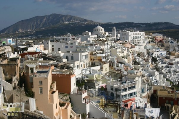
On Santorini, the flat lands are largely preserved for agricultural purposes [LEFT] while the the densely built Thira is located directly on the caldera [RIGHT].

The development strategies found in Greece’s large urban center, Athens, are probably the most relevant as the city has developed in a way to maximize their urban center in a way to preserve surrounding natural resources.

Athens is the capital of Greece and the hub of its economic activities. The city accounts for roughly one-third of the country’s total population while dating back to 3,000 BC. Similar to Cincinnati, Athens is located within the Attica Basic that is surrounded by mountains to the north, northeast, east and west with the Saronic Gulf situated like the Ohio River to the southwest. The natural boundaries helped to influence dense development patterns in the Greek capital much like early Cincinnati. Unlike Cincinnati though, Athens has largely maintained these natural barriers over time as a means for continuing dense, urban development that concentrates the region’s growth into a relatively small area.

The balance struck in Athens is one of sustainability impacts. The conquering development patterns on natural hillside landscapes are as non-sustainable environmentally as they are sustainable economically in their immediate setting. The environmental gains are seen through the preservation of natural resources outside of the urban center. Similar sustainability processes can be seen in other major cities around the world including New York City which boasts one of the lowest carbon footprints per capita even though the city made a previously natural habitat virtually unrecognizable.

Athens’ dominating urban landscape does not yield to the natural landscape in its urban core [LEFT] while Cincinnati’s urban landscape weakens immediately at its hillsides [RIGHT].

A more densely built urban environment in Cincinnati needs to occur for it to experience similar economic and environmental sustainability benefits. The region’s resources are spread too thin to provide adequate public services to all, the region’s population is spread too thin to experience robust cultural benefits, and the region is wasting some of the nation’s most fertile farmland for cheap, low-density single-family subdivisions and strip commercial development.

Before expanding out, the Cincinnati region should examine its available land resources and determine where infill is best suited. Vacant lots initially will make the most sense, but following that, Cincinnati’s hillsides should be seriously examined for smart development typologies like the ones found on the Greek islands that respect viewsheds, private property interests and the natural setting of the hillsides. This will not only make Cincinnati more economically and environmentally more sustainable, but it will make Cincinnati unique compared to other like cities across the United States that lack these creative hillside development opportunities.

Disclosure: Randy A. Simes worked for The Hillside Trust as a GIS Consultant from 2007 through 2009, and this editorial does not necessarily represent the views or values of The Hillside Trust.

Categories
Development News

Clifton Plaza an early success, improvements needed

Clifton Plaza took the place of the former Bender Optical building along Ludlow Avenue in the heart of Clifton’s vibrant neighborhood business district.  Early on in its concept people were concerned whether more open space was needed, or whether more businesses and people were needed in that central location.  After seeing the results of a recently completed streetscaping project in combination with the new Clifton Plaza, it now appears that additional public space was very much in demand.

The new public space created along Telford Avenue added simple, yet functional, park benches along with a new community board for event postings and other random information.  It took slightly longer to complete the new Clifton Plaza across the street, but the impact appears to be equally strong if early use is any indication.

The problem is not the creation of the new public space, but rather the design of it.  The primary design flaw of Clifton Plaza is the fixed seating.  Seating is extraordinarily important when it comes to public space design, and this type of seating design is straight out of the urban design playbook of two to three decades ago.  Since that time several studies have indicated that users prefer movable seating options where they can assert their control over the space.  This might mean the slight adjustment of a chair as one prepares to sit, or it might mean wholesale change to avoid or seek out sunlight.

“The possibility of choice is as important as the exercise of it.  If you know you can move if you want to, you feel more comfortable staying put,” explained William H. Whyte in The Social Life of Small Urban Spaces.  “This is why, perhaps, people so often move a chair a few inches this way and that before sitting in it, with the chair ending up about where it was in the first place.  The moves are functional, however.  They are a declaration of autonomy, to oneself, and rather satisfying.”

Whyte goes on to discuss how fixed seating is often awkward in public spaces as there is often much space around them as is the case at the new Clifton Plaza.

“The designer is saying, now you sit right here and you sit there.  People balk.  In some instances, the wrench the seats from their moorings,” Whyte continued.  “Where there is a choice between fixed seats and other kinds of sitting, it is the other that people choose.”

Beyond user preferance, fixed seating allows for a less functional space.  When planners redesigned Fountain Square, non-fixed seating in part helped to create a more open and flexible space better suited for the many events that attract thousands of people to the public space every week.

What works for Clifton Plaza is its large open area towards the back that will allow for flexible programming.  A simple fix could be made by removing these fixed seating options and replacing them with non-fixed alternatives.  This would create a more welcoming public space that encourages users to stay longer and take ownership of the space in a truly dynamic way.

Categories
Business Development News

Renderings for Moerlein Lager House released in latest CRP construction update

Cincinnati Riverfront Park Project Manager Dave Prather has released the latest construction update on the massive 45-acre public park project. In the video Prather discusses recent progress including the archaeological dig, event lawn, connectivity with The Banks development, bicycle commuter station and a realigned Mehring Way. The video also updates the status of the much anticipated Moerlein Lager House for which several new renderings are displayed.

The first phase of the Sasaki Associates-designed Cincinnati Riverfront Park will also include the Walnut Street Fountain & Steps, the Black Brigade Monument, the labyrinth, tree groves, the Women’s Garden, Main Street Garden, and the first section of the bike trail that will eventually connect with the Ohio River Trail. Construction of the park is currently on-budget and on-time for a Spring 2011 completion.

Categories
Development News

3CDC to host public hearing on Washington Park plans – 5/20

The Cincinnati Center City Development Corporation (3CDC) and the Cincinnati Park Board will be presenting their plans for the $46.2 million redevelopment of Washington Park on Thursday, May 20 at 6:30pm.  The presentation will be made at the Art Academy of Cincinnati just blocks away from the historic park in Over-the-Rhine.

Earlier this month 3CDC released new information on the redevelopment project including new renderings, financing plan and a general time frame for completion. Once complete, the renovated Washington Park will include a 500-space underground parking garage beneath a two-acre expansion of the park north to 14th Street. Other changes include the incorporation of a dog park, upgraded performance facilities, a splash ground to replace the existing pool, and other facility additions.

Some neighborhood residents have expressed concerns over the design of the new facilities in terms of how they relate to the existing urban fabric of one of America’s largest, and most significant historic districts.

“While this project has the potential to be a major boon to the community, and while the design of the garage and the redesign of the park are the result of lots of planning and hard work by 3CDC, the Park Board, and some community members, there are reports that certain aspects of the design still leave something to be desired, and that they may include some features that are gaudy and/or badly out of context with OTR,” explained Danny Klingler in an email sent to UrbanCincy. “For those of us that haven’t had a chance to participate in the planning process or see the designs, this is our opportunity to show up, view the plans, and express our opinions on the way Washington Park will look and feel, and the way it will interact with and affect the surrounding neighborhood.”

Since 2006, there have been six Steering Committee meetings and five general public meetings on this project.  Over that time, there has also been a number of organizational meetings including the Cincinnati Recreation Commission, Cincinnati Park Board, Over-the-Rhine Community Council and the Historic Conservation Board.

Officials working on the project hope to finalize financing and design plans soon so that construction work can begin this summer, with an expected completion in fall 2011.

The Art Academy is located on Jackson Street (map) near the Know Theatre. Free bicycle parking is available in the immediate vicinity, on- and off-street automobile parking is available for free and for payment, and the Art Academy can be reached by Metro bus service (plan your trip).