Categories
Arts & Entertainment News

Venue 222 to show The Maltese Falcon – 7/11

Venue 222 will be hosting its second movie night on Sunday, July 11 from 6pm to 10pm. The urban event space will be showing the 1941 adaptation of The Maltese Falcon which is based on the detective novel written by Dashiell Hammett. The film was nominated for three Academy Awards and is considered to be one of the greatest films of all time.

To compliment the film, Fork Heart Knife will be preparing 1940’s style food that will include Bacon Wrapped, Manchego Stuffed Dates; Chimichurri Chicken Skewers; Peppadew Deviled Eggs; Bloody Mary Gazpacho; Blueberry Lavender Jello Mold; and Mini-Brown Butter Sugar Cookies.

The film showing will take place at Venue 222 (map) and does require reservations as space is limited. The event costs $6 per person and reservations can be made online.

Categories
Development News Politics Transportation

Reconstruction of Fort Washington Way Redefined Cincinnati’s Urban Core

Fort Washington Way might be better known to some Cincinnatians as the I-71/US-50 trench through downtown Cincinnati, but few might know the full story behind how the current area came to be what it is today. Every Wednesday this July, UrbanCincy will cover a part of the history of Fort Washington Way, its construction, the political fights that came with it, and the potential future for the area. Furthermore, the unprecedented foresight that the engineers, politicians, and public alike demonstrated through the construction will be highlighted.

The City of Cincinnati developed where it is today because of its location on the Ohio River. The river served as the primary economic engine for the city and therefore the larger region. As such, the fact that Fort Washington Way bisects the urban core from the riverfront troubles individuals who wish to see the city become whole once again. However, it is important to remember what the stretch of land looked like prior to major renovations a decade ago.

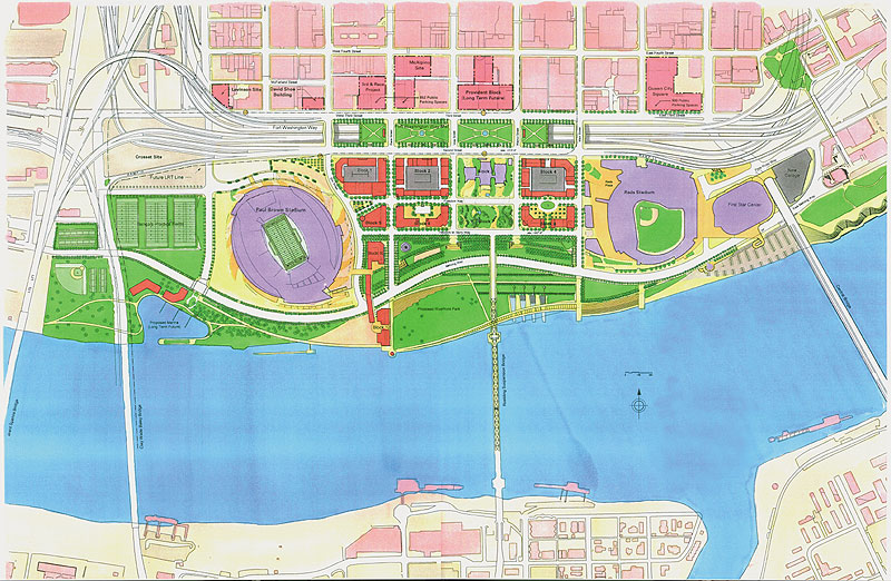
In 1998, construction began on the approximately 1.25-mile stretch of highway. Originally, the plan included burying the stretch of highway completely in order to hide the highway eyesore from the remainder of downtown. However, that idea was overturned in 1996 because many people wanted to ensure that visitors to the city would be able to see it as they traveled through. New plans were completed and construction began.

In 1999, after more than two-thirds of the renovations were complete, there was renewed interest in burying the highway. Proponents claimed that a buried highway would ensure an uninterrupted transition from downtown to the riverfront. The engineers knew that they wouldn’t be able to finish the project on time and on budget if they changed the project so late, so they compromised by sinking the roadway below the level of the rest of downtown’s street grid. Part of this compromise included driving extraordinarily strong support piles into the ground that were engineered to hold caps that could eventually cover the highway if the decision was made to do so at a later date.

The current gaps between segments of the street spanning over Fort Washington Way are spaced such that caps 600 feet wide could be installed with relative ease and with a gap between segments. Gaps ensure that the area is not officially a tunnel, and as a result, the dangers and costs associated with the fire safety precautions of a tunnel are avoided. Engineers state that the pilings supporting the caps could withstand the weight of several feet of dirt, making an unique and exciting urban park possible. Furthermore, the caps could support the weight of buildings approximately four stories high. The latter options would provide the opportunity to link The Banks development with the rest of downtown abutting the current trench.

The major change in the 1998 redesign came by untangling and streamlining the mess of highway on- and off-ramps. Doing so allowed the roadway to carry a greater capacity, increase safety, and dramatically decrease the total width of Fort Washington Way. Once construction was completed, about 40% of the original width was gone as a result of the better design. The space that was saved freed up room for the Great American Ball Park, National Underground Railroad Freedom Center, Paul Brown Stadium and much of The Banks development.

In the next three weeks, UrbanCincy will highlight how this transformation took place. In the process, we will show how the city demonstrated an unprecedented level of foresight, saving current and future taxpayers untold sums of money. The inter-jurisdictional cooperation that this project achieved set the stage for the redesigned area to win more than a dozen national and international awards.

As one engineer told me: “We weren’t highway building. We were city building.” Check back each Wednesday in July to learn more about how Fort Washington Way project impacted current and future development.
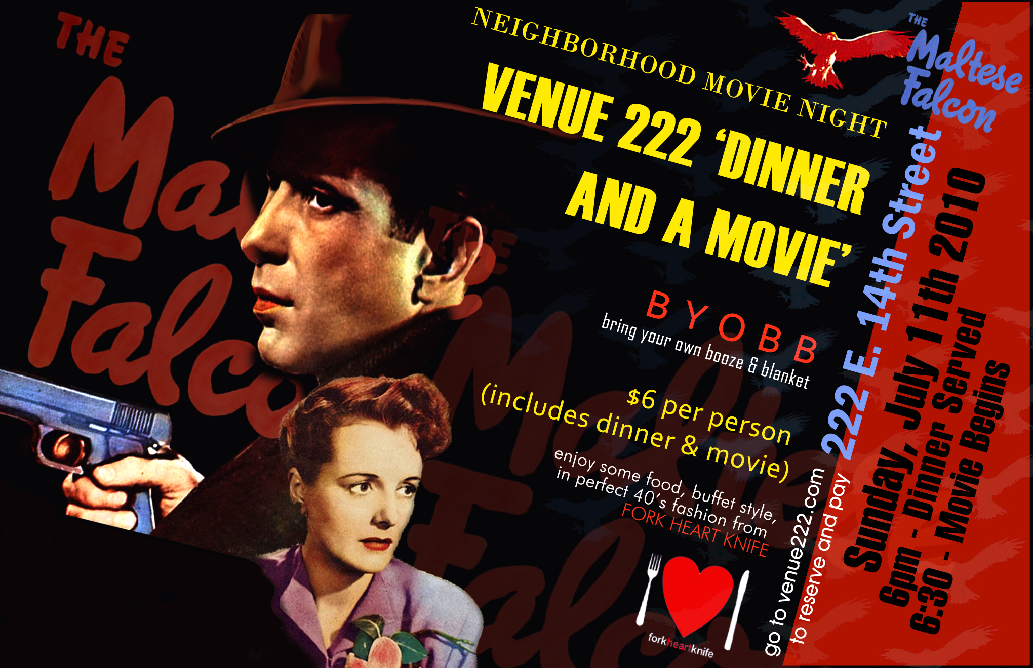
Categories
Business Development News

Great American Tower rises triumphantly above downtown Cincinnati

Crews from Turner Construction Company continue to work on the finishing touches of Cincinnati’s new tallest skyscraper that will house a variety of companies including Great American Insurance for which the Great American Tower gets its name.  The $322 million office tower boasts more than 800,000 square feet of office space and is scheduled to welcome its first tenants in spring 2011.

The Great American Tower is part of the larger Queen City Square development which includes the 303 Broadway office tower next door.  The two towers share a 2,200-space parking facility and exterior design features.

The new tower has reached its highest point at 665 feet above Third Street with its majestic “Tiara” atop the structure’s 41st floor.  UrbanCincy photographer Jake Mecklenborg was invited to tour the new tower as crews finish the structure’s crowning design feature.  Mecklenborg’s photographs capture dramatic views from the top of the tower of Over-the-Rhine, Downtown, The Banks and the Cincinnati Riverfront Park.  He also captures crews hard at work throughout the project.

Eagle Realty is currently working on leasing the final 175,000 square feet of office space at the Great American Tower on floors 28, 29, and 35 through 38.  Once complete, the tower will house thousands of business workers, new retail offerings, and a dramatic new architectural feature to downtown Cincinnati that will eclipse historic Carew Tower as the tallest structure in the Ohio River Valley.

Categories
Business Development News

CPA event to highlight Bellevue’s preservation success story

Cincinnati Preservation Association (CPA) and the City of Bellevue, KY will host a tour of the small Bellevue community along the Ohio River on Friday, July 9 from 9:30am to 12:30pm.

Bellevue has been recognized for its successful preservation techniques that have worked to revitalize the city’s neighborhoods and historic commercial district along Fairfield Avenue. Those attending the tour will have the opportunity to learn about the city’s innovative programs that have gotten it where it is today. Such programs include Bellevue’s local historic district and ongoing form-based code initiative.

The event will take place at the Callahan Community Center (map) and is free and open to the public. CPA is asking that those interested RSVP by calling (513) 721-4506 or emailing info@cincinnatipreservation.org.

UPDATE: Due to timing issues, the tour of Bellevue originally scheduled for Friday, July 9th has been canceled.  CPA officials say that the event will be rescheduled for a later date.

Categories
Arts & Entertainment Business Development News

Traffic revisited ten years later in Cincinnati

The last major motion picture to be filmed in Cincinnati was the 2000 box office hit Traffic which highlighted America’s relationship with drugs.  In the movie, a conservative politician from Cincinnati was appointed as U.S. Drug Czar all while his young daughter deals with a drug addiction of her own.  The wealthy politician, and his family, lived in the extraordinarily affluent Indian Hill neighborhood, and his daughter would travel into Cincinnati’s inner city to support her drug habits.

The movie focuses on the wide reach of drugs in contemporary American society and illustrates the role both wealthy and poor individuals play in the drug trade.  The movie portrayed the inner city as a place of decay where the dirty elements of the drug trade take place.

Filmmakers chose Over-the-Rhine because of its urban form and its state of decay that helped tell the story at the time the movie was filmed.  Since that time a dramatic revitalization has occurred throughout Cincinnati’s inner city that has included the renaissance taking place in Over-the-Rhine that has netted hundreds of new residents, dozens of new businesses, and plummeting crime rates.

Soapbox takes a look the locations used in Traffic ten years after the movie first entertained audiences.  The video, produced by 7/79 ltd, shows that most all of the locations have been rejuvenated over that time, and those involved with the film say that Over-the-Rhine continues to be a draw for filmmakers as it provides an affordable alternative to filming in New York while providing a similar urban form to use.

“A big part of their decision to come to Cincinnati was Over-the-Rhine.  They just fell in love with that whole area, and felt that it had a wealth of opportunities and architectural detail to offer the film,” said Deidre Costa, Location Manager for Traffic.  “I would say hands down that the biggest selling point of Cincinnati has been Over-the-Rhine.”