Categories
News Opinion Transportation

Here’s How to Improve Access Between Ohio and Kentucky’s East/West Neighborhoods

When discussing regional transportation issues, the topic seems to always be about congestion. In reality, outside of a few limited periods, the Cincinnati region has relatively good traffic flow with little actual congestion. So instead of trying to solve a problem that does not exist, we should be instead focusing our resources on maintaining our current system and improving mobility within the overall region.

As is the case in any city, the natural environment often serves as a chokepoint and barrier to regional mobility. This is true for Cincinnati with its hills and rivers.

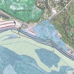
With the region’s population largely centered along the Ohio River, it is natural that this is where the most choke points exist. Outside of the center city, however, there are very few river crossings. In fact, there are only two Ohio River crossings outside of the center city, and both of those are for I-275.

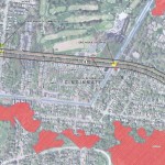
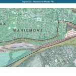
One such area that makes sense for a new local road bridge is around Cincinnati’s Columbia Tusculum neighborhood and Dayton, KY near where the $400 million Manhattan Harbour project is planned.

An increasing amount of development continues to occur on the northern bank of the river in Columbia Tusculum and East End. Further up the hill sits prosperous neighborhoods like Mt. Lookout, Hyde Park, and Oakley; and just around the bend lies Lunken Airfield.

Conversely, on the south side of the river in Kentucky, large-scale development projects have long been envisioned, but are often derailed due to poor access via existing roadway networks. This remains true for Manhattan Harbour where concerns exist about the traffic burden that would be placed on the narrow KY 8 running through historic Bellevue’s quaint business district.

A local road bridge that is one lane in each direction with space for pedestrian and bicycle paths would be an ideal fit for this area of the region. It would improve mobility and access to two difficult-to-access areas. It would also offer a highway alternative for those looking to cross between the two states.

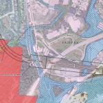
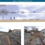
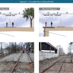
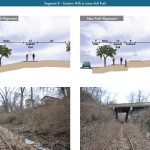
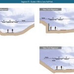
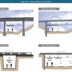
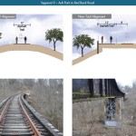
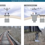
A second location where a local bridge of this nature would make sense is near where the Anderson Ferry currently operates today on the city’s west side.

While little development has occurred in this area for some time, this may soon change. The Ohio River Trail West will soon make its way toward this area, and several developers have been eyeing the western riverfront for major projects.

The Cincinnati-Northern Kentucky International Airport sits on the southern side of the river where this bridge would land. This area continues to be bolstered by warehouses, distribution facilities and other airport-related services, and could be further bolstered with better access. What’s more, Cincinnati’s western neighborhoods that have long had to deal with excessive airplane noise, yet long treks to the airport, could at least resolve one of those injustices with a new local access bridge.

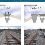
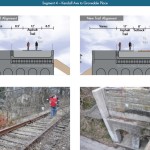
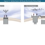
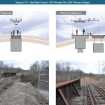
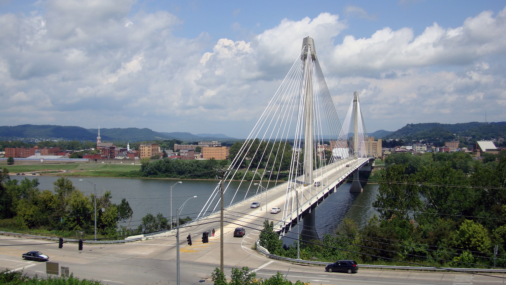
The Taylor-Southgate Bridge is the most recent span that has been constructed over the Ohio River. It was completed in 1995 and cost $56 million at that time – approximately $85 million when adjusted for inflation. Both of these new bridges would need to span an approximate 1,700-foot-wide width, which is about 300 feet more than the Taylor-Southgate Bridge river width.

One of the main differences, however, is that the Taylor-Southgate Bridge includes two lanes of traffic in each direction, plus sidewalks. The need for only one lane of traffic on these bridges would allow them to have a deck width of around just 30 to 35 feet.

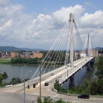
Another good nearby comparison is the U.S. Grant Bridge in Portsmouth, OH. That cable-stayed bridge was completed by the Ohio Department of Transportation in 2006 for approximately $30 million – or about $35 million in today’s dollars.

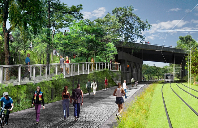
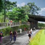
In addition to access and mobility improvements for motorists, a new bridge in both of these locations would also be a boon for cyclists. Those riding along the Little Miami Scenic Trail and the Ohio River Trail would now also be able to continue on to Northern Kentucky’s Riverfront Commons Trail, which will eventually stretch 11.5 miles from Ludlow to Ft. Thomas.

The Cincinnati region does not need multi-billion dollar solutions for a traffic congestion issues that largely do not exist. Reasonable and affordable projects that aim to increase mobility and access, along with maintaining our existing assets, should be the priority.

New local bridges connecting the region’s east and west side neighborhoods would open up land for new development, improve access between both states, enhance mobility for pedestrians and cyclists, and would do so at a price tag we can afford.

Categories
Development News Transportation

Cincinnati Reaches Agreement With Norfolk Southern on Purchase of Wasson Railroad Corridor

Cincinnati City Council’s Neighborhoods Committee gave a unanimous okay to an ordinance that would solidify an agreement to purchase 4.1 miles of railroad right-of-way from Norfolk Southern for $11.8 million, providing a key piece of the 7.6-mile Wasson Way recreational trail.

The agreement would give the City a two-year purchase option for the property, which extends between the Montgomery-Dana intersection along the Norwood/Evanston line to the intersection of Red Bank and Wooster roads in Columbia Township.

The ordinance was a last minute by-leave item on the committee calendar, made necessary due to a TIGER grant application that is due on Friday. Project backers are seeking $17 million of the $20 million project cost, and City support makes their application much more attractive.

The trail has been in the works since 2011, and a group of nearly 20 volunteers with the Wasson Way nonprofit got a big boost when Mayor John Cranley (D), City Manager Harry Black, and City staff assisted with the negotiations.

“We started looking at the TIGER grant application,” said Mel McVay, senior planner at Cincinnati’s Department of Transportation & Engineering. “They really talk about ‘ladders of opportunity’, increasing mobility and accessibility for folks throughout the region, and so we saw an opportunity between the property we could purchase and some property we already had, and some existing trails.”

Director of Department of Trade and Development Oscar Bedolla spelled out the project’s urgency.

“One of the statutory requirements associated with the scoring for TIGER is related to readiness,” he said. “And so, the more that we can do to show that the project is potentially shovel-ready enhances our ability to acquire or be selected for TIGER funding.”

Bedolla added that under the terms of the agreement, the City would pay nothing in the first year if it does not proceed with the purchase. If the purchase is pursued within the second year, there would be a 5% fee added to the price.

The City’s matching funding of between $3 million and $4 million for construction costs could be made up of a combination of state and federal grants, plus funds raised by Wasson Way, he said.

Still up in the air is approximately two miles or the corridor between the Columbia Township end point and Newtown, where it could connect with the Little Miami Scenic Trail.

“We’re working on it,” McVay said. “Unfortunately, the railroad was not open to selling any additional property east of that point. We’re investigating three or four ways that we can get farther east to the existing Little Miami Trail. We’re very confident we can get there.”

David Dawson, a resident of Mt. Lookout and realtor with Sibcy Cline, expressed concern about how a long-envisioned light rail line could be brought to the corridor once its freight rail designation is abandoned – a legal process that is handled by the U.S. Surface Transportation Board.

“It just can’t be said enough, in my view, that the City will now become the steward of a very valuable asset,” Dawson said. “This is a regional corridor that, in this day and age, cannot really be duplicated. If we lose that ability to eventually have transit, rail transit, or some sort of transit in the future, we won’t be able to put it back.

Dawson and other rail advocates are calling for the corridor to be railbanked, so that the addition of light rail transit remains an option in the future.

“This doesn’t just connect our neighborhoods, but in the future it has the potential to connect the entire region out to Clermont County,” Dawson said.

The use of this corridor has long been eyed for light rail transit, including in the 2002 MetroMoves regional transit plan. A 2014 study by KZF Design recommended a design solution that would preserve the ability to develop both light rail transit and a trail; and estimated that such an approach would bring the cost of developing the trail to approximately $11.2 million.

Andrea Yang, senior assistant City solicitor, said that the purchase agreement would give the City some time to work out those issues.

“The way that the abandonment process is structured, there is a time period which we could utilize to further investigate other options,” Yang said. “Had we chosen to railbank the property and attempt to preserve it, it would actually follow the same process for abandonment, so there’s definitely time to look into that if that is what Council’s interested in seeing.”

In April, Cincinnati’s Planning Commission voted to place an Interim Development Control Overlay District on this corridor in order to give the city more time to allow plans to progress without new development creating new conflicts.

Categories
News Transportation

New Center City On-Street Parking Rates, Hours of Enforcement Now In Effect

New parking rates and hours of operation went into effect for the Central Business District and Over-the-Rhine on Friday. The changes come after Cincinnati City Council approved the matter in November 2014.

Under the arrangement, 500 new electronic parking meters have been installed throughout Over-the-Rhine to complement the existing set already in place in the Central Business District. Over the coming weeks, the City of Cincinnati will also be installing 1,000 additional electronic meters throughout the Clifton, Hyde Park, Mt. Lookout, Northside, O’Bryonville, Oakley, and Pleasant Ridge neighborhood business districts, as well as key locations throughout Uptown.

The electronic meters, officials say, are meant to replace the old ones with newer models that accept credit card payments and are compatible with future plans for pay-by-phone technology and dynamic pricing structures. Pay-by-phone capabilities are expected to be operational by the middle of 2015.

While nearly a dozen neighborhoods will benefit from the new technology, only Over-the-Rhine will see its on-street parking policies change across the board. As part of the new policy, parking rates in Over-the-Rhine will double to $1/hour; while rates will remain set at $.50/hour and $2/hour in the other neighborhoods and in the Central Business District, respectively.

As of today, parking meters in the Central Business District and Over-the-Rhine will now also be in effect from 9am to 9pm Monday through Saturday, and 2pm to 9pm on Sundays. Parking hours of enforcement in the remaining 50 neighborhoods, meanwhile, will remain unchanged.

The sweeping changes are meant to help improve the performance of the City’s broken parking system. While many small business owners in Over-the-Rhine have expressed their support for the changes, especially in light of ongoing vandalism of meters in Over-the-Rhine, some believe they have been singled out following the cancellation of a previous agreement that would have raised rates and increased enforcement city-wide.

“I’m not opposed to longer meter hours and higher rates, but what upsets me, as an OTR resident and business owner, is the fact that our neighborhood has been singled out,” Jean-Francois Flechet, owner of Taste of Belgium, wrote in a Facebook post. “The same hours and rates should apply to other neighborhoods.”

The original Parking Lease & Modernization Plan approved in early 2013 was, of course, cancelled by Mayor John Cranley (D) almost immediately upon his arrival at City Hall at the end of 2013. While the mayor and many members of City Council bemoaned the previous plan, a similar plan appears to be taking shape, but in a piece-by-piece approach.

As like the original plan, new electronic meters are being installed that accept credit card payments and utilize dynamic pricing models, meters are being upgraded city-wide, and a contract has been signed with Xerox.

The Cranley Administration has not yet commented on plans for new hours or rates in the city’s remaining neighborhood business districts, where on-street parking meters exist, but they do say that they intend to systematically create multi-space parking that will “produce more aesthetically clean public right-of-way areas in Over-the-Rhine.”

This means that the newly retrofitted parking meters in the historic neighborhood will eventually be removed to make way for multi-space equipment, similar to what has been used in the Central Business District in the past. The upgraded parking meters from Over-the-Rhine will then be shifted to other neighborhoods throughout the city. This process, officials say, could begin as soon as this spring.

In addition to the specific focus on center city neighborhoods, the new parking policy differs from the previously approved plan by creating Sunday hours of enforcement. While the new Sunday hours of enforcement are only in effect for the Central Business District and Over-the-Rhine, it crosses what was considered a red line in the previous public debate over proposed parking changes.

All of the changes are expected to bring confusion to those parking in the affected areas, including a large group of people who drove to Christ Church Cathedral for the Boar’s Head & Yule Log Festival on Sunday. According to Michelle Dillingham, Director of Education at the Greater Cincinnati Coalition for the Homeless, parking enforcement officers ticketed many cars parked on the street during the event.

“I walked out of the Boar’s Head event that was barely an hour long and almost every car had a parking ticket on their windshield…on a Sunday and in front of a church celebrating 75 years of a Cincinnati tradition,” Dillingham wrote. “I don’t know, but it just rubbed me wrong.”

The former Cincinnati City Council candidate went on to say that she had two separate conversations with people, who lived outside of the center city, that were very upset by the situation and would reconsider visiting downtown again due to the aggressive parking enforcement.

City officials acknowledge that there will be a bit of a learning curve, and say they are working to improve awareness of the new rates and hours of enforcement by distributing flyers and working with groups like Downtown Cincinnati Inc. and the Over-the-Rhine Chamber of Commerce to inform drivers of the changes.

Categories
News Transportation

City Planners Recommend Transportation Overlay District for Wasson Railroad Corridor

Following the guidance of City Council, Cincinnati’s Department of City Planning & Buildings has completed its land use study for the Wasson Railroad Corridor. The study’s findings and recommendations offer the clearest guidance to-date as to how to proceed with redeveloping the abandoned freight rail corridor, following the issuance of preliminary designs in July 2014.

City planners took a comprehensive look at the history of the corridor, its current conditions and the best path forward that respects the desires of the city and the impacted neighborhoods.

In that analysis City staff revealed seven studies and plans that recommend the corridor either be used for rail transit, or a combined multi-modal network that accommodates rail transit, bicycles and pedestrians. Some of the most notable of these include the 2002 MetroMoves regional transit plan, 2010 Bicycle Transportation Plan, 2012 comprehensive Plan Cincinnati, and the 2013 Railroad Safety Improvement Plan – all of which either specifically call for the corridor to be used for rail transit, or a multi-modal corridor.

The history is important as it influenced the study’s recommendation as to how to proceed with acquiring and preserving the corridor. As of now, the 5.7-mile Wasson Railroad Corridor is still owned by Norfolk Southern, but the City of Cincinnati has stated that they are in the process of acquiring the property from them.

“With this corridor being so crucial to the future development of multi-modal transportation in the City, the threat of potential development within the railroad right-of-way would significantly slow down, if not completely hinder, those possible public transportation opportunities from occurring,” city planners wrote in the 32-page land use study released earlier this month.

Of course, this fact has been known by policy makers at City Hall for years. As a result, City Council has, on several occasions, approved interim development controls to protect the corridor from being built upon. These controls, however, are just temporary and city officials must now decide how they would like to move forward.

In the study city planners examined the pros and cons of three potential options for accomplishing this.

The first option examined the idea of rezoning the property to a Parks and Recreation classification. This would offer the corridor significant protections, but it would also severely restrict the City from being able to implement rail transit in the future due to federal regulations that prohibit the use of public parks or wildlife refuges for transit corridors.

A second option studied looked at simply dedicating the land as City right-of-way. This too would offer significant protections, but is not possible until the City acquires the land from Norfolk Southern.

The third option, and the one recommended by city staff, is enacting a Transportation Overlay District over the corridor. While planners admit that crafting the language for such legislation may be complicated, they also stated that it would be most aligned with the preferences of neighborhood residents and publicly adopted planning documents.

In order to address the complexity of the legislation required for such an overlay district, city planners recommended looking at the Atlanta BeltLine Overlay District that was implemented to protect a 22-mile abandoned freight rail corridor. In Atlanta civic leaders are currently in the process of converting the corridor into a similarly envisioned multi-modal network with rail transit, bikeways, parks and pedestrian paths.

“While all options present advantages and disadvantages, the Transportation Overlay District is seen as the best solution for preservation of the Wasson Railroad Corridor,” city planners wrote. “This tool, while it may take a bit longer to craft the ordinance language, will provide more flexibility and also protect the contiguous nature of the corridor.”

City officials say that this solution will allow for the development of the Wasson Way Trail to move forward in the near term, while affirming the City’s intentions to develop the corridor as a multi-modal transportation facility that includes rail transit in the future.

The solution crafted by the Department of City Planning & Buildings appears to be a perfect compromise between the two constituencies looking to use the corridor. Bicycle advocacy groups can see the right-of-way acquired and preserved so that they can move forward with their plans for a bike and pedestrian trail, while transit advocates can rest assure that those immediate efforts are not being done in conflict with ongoing planning and design work for a future light rail line.

With the Wasson Railroad Corridor Land Use Study now complete, it will go before the city’s Planning Commission. Should it be approved by Planning Commission, it will then go back to city staffers so that draft overlay district language can be crafted and recommended to City Council. From there, it would go before City Council for approval.

It is a standard process and one that advocates hope can be completed in the coming months.

Categories
Development News Transportation

KZF Releases Preliminary Designs, Cost Estimates for Wasson Way

A newly released feasibility study, produced by KZF Design, finds that construction of the 6.5-mile Wasson Way Trail would cost anywhere from $7.5 million for just a trail to $36 million for both a light rail line and trail totally separated from one another.

The cost estimates vary so much due to the three potential design options studied. The lowest cost alternative looked at placing a 12-foot-wide trail along the entire existing rail alignment. This, however, would make the inclusion of a future light rail line extremely difficult.

The most expensive alternative would construct an entire new trail alignment that does not interfere with any existing rail right-of-way. This would include the construction of several new bridges and completely preserve the ability to easily construct the long-planned light rail line adjacent to the new trail.

Alternative B, which was recommended by KZF and priced at $11.2 million, was a bit of a hybrid. It would include a 12-foot-wide trail offset from the existing rail alignment, but utilize existing rail right-of-way at pinch points along the corridor.

The 45-page study is the first detailed look at the corridor, which has been hotly debated and discussed over recent years. Much of the controversy has surrounded whether or not both light rail and a trail can be accommodated. KZF’s findings appear to show that much of the corridor could in fact accommodate both, but that some segments may prove to be difficult, albeit feasible.

If project supporters are able to advance the trail plan, KZF estimates that it would connect eight city neighborhoods and approximately 100,000 residents with an overall network of more than 100 miles of trail facilities.

“It is hard to build in the urban core, and to find an intact corridor ripe for development is a unique thing,” explained Eric Oberg, Manager at the Midwest Rails to Trails Conservancy. “If this is done right, this can be the best urban trail in the state of Ohio. I have no doubt.”

Some of the most difficult segments of the corridor are the nine existing bridges where the right-of-way is extremely limited. If both light rail and trail facilities are to traverse this corridor together, additional spans will be needed in order to have safe co-operation.

In addition to introducing what may become the region’s best urban trail and light rail corridor, some proponents also see it as an opportunity to fix other problems along the route. Most notably that includes the congested and confusing intersection of Madison, Edwards and Wasson Roads near Rookwood Pavilion.

While the newly released feasibility study offers the most detailed analysis of this corridor to date, the City of Cincinnati has yet to close on its purchase of the former freight rail line from Norfolk Southern.

City officials are reportedly in negotiations with Norfolk Southern now, and have made an initial offer of $2 million. In April, Mayor Cranley’s Administration also allocated $200,000 to the project.