Categories
Development News Transportation

Elm Street Cycle Track Would Provide Critical Link for Region’s Bike Infrastructure

The city will start construction on physically separated bike lanes along Central Parkway, from Downtown to Clifton, this coming spring. Following a community engagement process, a final design was selected in recent weeks, and the large addition to Cincinnati’s bike network is expected to make a significant impact.

Not only will it be one of the most impressive bike facilities installed in the region to-date, but it will also link neighborhoods together that have large percentages of bicyclists. Furthermore, it will link other bike facilities with one another, and come close to linking even more.

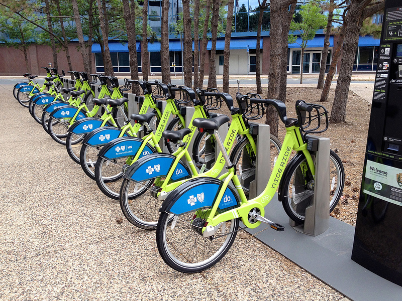
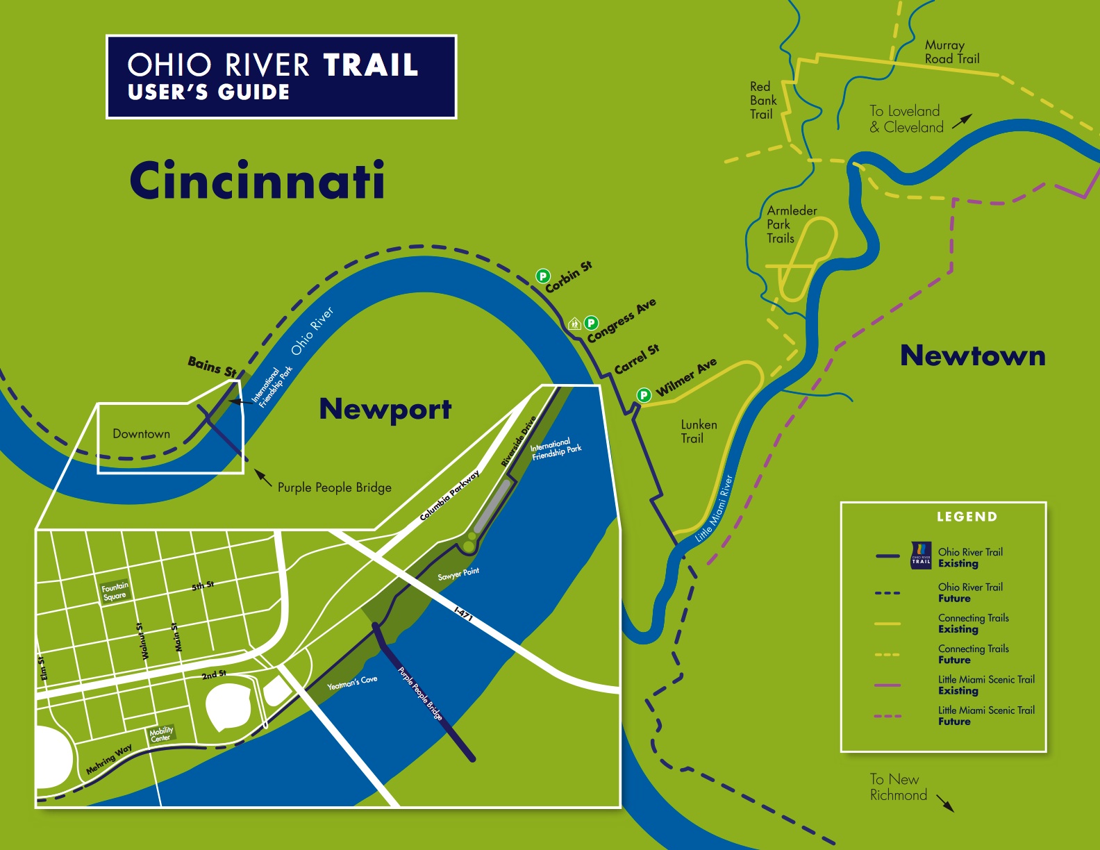
Some of the existing facilities include numerous bike lanes and the Mill Creek Greenway, but the Central Parkway bike lanes will come about 12 blocks shy of connecting with the Ohio River Trail, which then links to the Little Miami Scenic Trail.

A two-way cycle track should be built in order to connect the new Central Parkway bike lanes with the Ohio River Trail and beyond.

Elm Street Cycle Track

There are two streets that connect from Central Parkway to the Ohio River Trail along Mehring Way without interruption: Main Street and Elm Street. Both of the streets have one-way traffic heading northbound, but Main Street is considerably more congested with cars and buses heading to Government Square.

Elm Street, however, has some of the least congestion of any north/south street in the Central Business District and could easily connect the Central Parkway cycle track with the Ohio River Trail. A reorganization of the street would need to occur however.

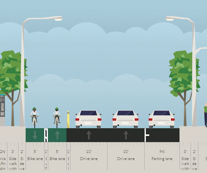
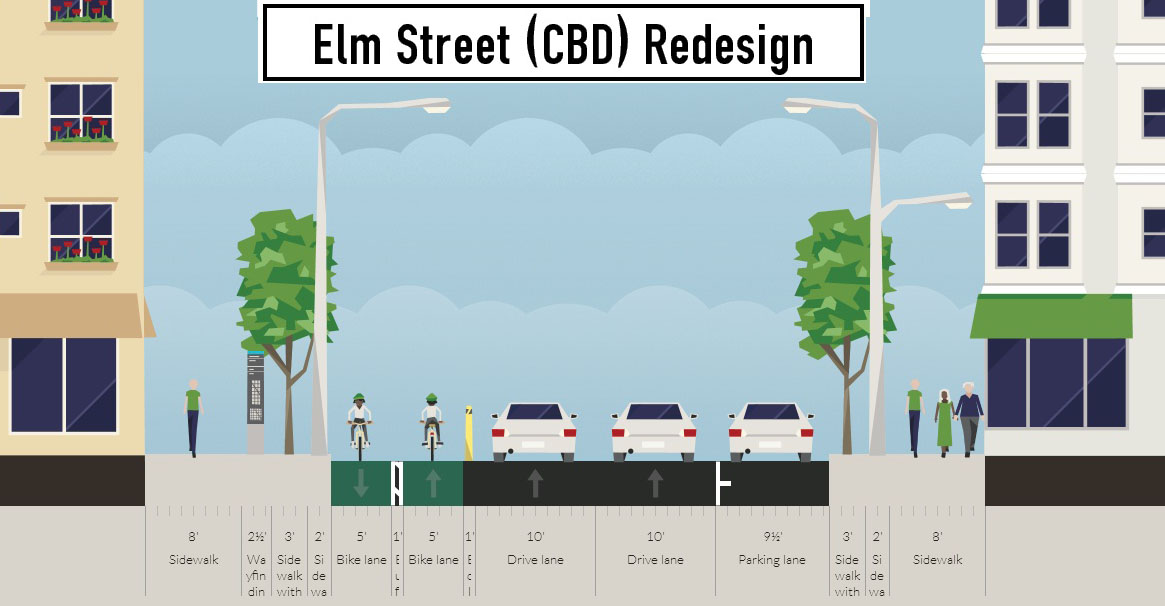
Presently Elm Street, from Central Parkway to Mehring Way, lacks consistency in its design with on-street parking located haphazardly along both sides of the street. A reconfiguration of the street could consolidate all on-street parking to the east side of the street, thus eliminating only a nominal number of on-street parking spaces, and maintain 2 to 3 moving traffic lanes (the parking lane could be restricted during rush hours to allow for a third travel lane).

The Elm Street cycle track, meanwhile, would be located along the west side of the street and be buffered from moving traffic by a row of bollards. Such a redesign of Elm Street would be a bit of a road diet, but one that seems reasonable for this stretch of overbuilt roadway.

Planners with the City’s Department of Transportation & Engineering (DOTE) said that the idea of an Elm Street cycle track had not come up before, and has not been presented to any formal committees or community councils to-date. Such coordination, they say, would need to take place prior to the idea moving forward.

With future phases of The Banks and the yet-to-be-named residential tower on Fourth Street set to begin construction soon, there seems to be an opportunity to rebuild this roadway along with those projects. This would help offset some of the costs and make for a more seamless transition.

Projects like this are low-hanging fruit for the new mayor and council, should they wish to pursue investments that improve the city’s bike infrastructure. They should work with the bike community and come up with a strategy that provides a clear path forward to make this happen.

An Elm Street cycle track like this would provide a critical link in the region’s bike network, make the street safer, more accommodating to more users and more attractive to those who currently find themselves along the now bleak and desolate stretch of roadway. Let’s get to work.

Categories
Business Development Transportation

Cincinnati City Leaders to Move Forward with Ohio’s First Bike Sharing System

A new study, prepared by Alta Planning + Design, has determined how and where a bicycle sharing system could be implemented in Cincinnati in a way that will compliment its expanding Bicycle Transportation Program.

The recently released report was called for by city leaders in May 2012, and identifies a 35-station, 350-bike system that would be built over two phases in Downtown, Over-the-Rhine, Pendleton, Clifton Heights, Corryville, Clifton, Avondale and the West End.

“We went into this study wanting the public to be a big part of the process. They contributed more than 300 suggestions for stations and cast nearly 2,000 votes,” said Michael Moore, Director of the Department of Transportation & Engineering (DOTE). “Thanks to all their input, this study helps ensure bike share is relevant and useful to the residents and commuters in the downtown neighborhoods.”


Several neighborhoods throughout the city were determined as potential areas to be included in a future Cincinnati bike share system. Map provided by Alta Planning + Design.

City officials also say that locations throughout northern Kentucky’s river cities were also popular, and would make for a logical expansion in the future should system arrangements be achieved.

According to the report, the 35 station locations were identified through public input and through a variety of suitability factors that include population density, percentage of residents between the ages of 20 and 40, employment density, mixture of uses and entertainment destinations, connectivity with existing and planned transit networks, and the terrain in the immediate area.

“In general, there are enough positive indicators to suggest that bike sharing is feasible in Cincinnati,” Alta Planning + Design wrote in the 49-page report. “There are no fatal flaws, although a smaller dependency on visitors and ordinances restricting advertising would need to be overcome to make the system financially viable.”

The financial viability of the project is particularly important in Cincinnati’s case as city officials have determined that a privately owned and operated system would be the best business model for Cincinnati.

Alta Planning + Design estimates that the potential 35-station system, spread throughout Downtown and Uptown, would cost approximately $2 million to construct and nearly $200,000 to operate annually. While user fees are expected to sustain a portion of the annual operating costs, system operators will most likely need a variance to city law to allow for advertising on the stations, as is commonplace for bike sharing systems throughout the world.

     
More than 2,000 responses helped determine public support for potential station locations [LEFT]. The initial system would be built out over two phases in Downtown and Uptown [RIGHT]. Maps provided by Alta Planning + Design.

“As of now we do not intend to invest any public funds in the system, other than in-kind assistance with marketing and station siting,” explained DOTE Senior City Planner Melissa McVay, who recently sat down to discuss Cincinnati’s bike culture on Episode #8 of The UrbanCincy Podcast.

Annual membership fees and hourly rates would be determined by the eventual company selected to operate the system, and would be contingent upon how much money could be raised through advertising and local sponsorships.

In addition to drilling into local details and demographics pertinent to a potential Cincinnati bike sharing system, the feasibility study also compared Cincinnati to other cities throughout North America that have operational bike sharing systems.

Through that analysis it was found that Cincinnati’s system would be smaller than those in Miami, Boston, Washington D.C., Montreal and Toronto, but that it would be larger than systems in San Antonio, Des Moines and Chattanooga. Cincinnati’s system is also anticipated to have a more favorable trip comparison, for the first year of operation, than both Minneapolis and Denver.

The report also estimates that Cincinnati’s system would attract 105,000 trips in its first year of operations, with that growing to 305,000 in year five once both Downtown and Uptown regions are operating, with approximately 25 percent of trips replacing a vehicle trip.

“We want Cincinnatians to be able to incorporate cycling into their daily routine, and a bike share program will help with that,” Moore explained. “Bike share helps introduce citizens to active transportation, it reduces the number of short auto trips in the urban core, and it promotes sustainable transportation options.”

The City of Cincinnati is expected to issue a request for proposals, within the next month, that will call for bids from an operator of the planned system. If all goes according to plan the Midwest’s sixth, and Ohio’s first, bike share system could become functional as early as the operator’s ability to acquire funding.

Categories
News Transportation

Cincinnati’s Efforts to Improve Urban Bicycle Culture Paying Huge Dividends

Cincinnati’s aggressive efforts to bolster bicycle infrastructure appear to be paying dividends. In a report released by The Atlantic Cities, it was discovered that Cincinnati has experienced a 200 percent increase in those commuting by bicycle over the past decade.

The study found that many cities across the United States, particularly those in the Northeast and Midwest, experienced rapid increases in the number of bicycle commuters.


Commuter bicycle growth from 2000 to 2009 – Source: The Atlantic Cities.

While Cincinnati saw one of the fastest growth rates in the entire nation, it also now boasts the fifth highest overall percentage of bicycle commuters in the Midwest. Only Columbus, St. Louis, Chicago and Minneapolis have a higher percentage of bicycle commuters than Cincinnati.

That news was further punctuated Cincinnati’s “Honorable Mention” at the 2011 Bicycle Friendly Community awards held in Washington D.C. At the awards, only 22 cities were recognized nationwide.

“Bicycling is a critical component of vibrant urban areas,” explained Michael Moore, Director, Department of Transportation & Engineering (DOTE). “Bicycle Friendly Communities provide more transportation choices for citizens, are more physically active, environmentally sustainable, and enjoy increased property values, business growth, and increased tourism.”


Temporary on-street bicycle parking for the MidPoint Music Festival – Source: Queen City Bike.

City leaders believe the wave of good news comes as a result of significant policy decisions made over the past several years that have included new on-street bicycle parking; passage of comprehensive bicycle safety legislation, legislation requiring bicycle parking in all new parking garages, and a comprehensive bike plan; the launch of a Bicycle Friendly Destinations program; the construction of a new Bike & Mobility Center at the Smale Riverfront Park; and the completion of new bike lanes, sharrows, and bike trails throughout the city.

Recent decisions to install temporary on-street bicycle parking for the MidPoint Music Festival seem to further emphasize the city’s prioritization of the two-wheeled mode of transportation.

In total Cincinnati city officials plan to have 340 miles of bike lanes and paths in place by 2025. Currently the city has only 20 miles of bike lanes and paths in place, with five of those miles being installed over the past year. Future plans call for completing the remaining segments of the Ohio River Trail and adding additional miles of sharrows, dedicated bike lanes and paths.

For comparison, an infusion of money similar to that of the Brent Spence Bridge project ($2-3 billion) would enable the construction of roughly 20,000 miles of dedicated bike lanes, and pay for their maintenance.

Categories
News Transportation

Ohio River Trail Tour to explain bike commuter center basics this Sunday

To wrap up the end of Bike Week (and Bike Month), UrbanCincy and the City of Cincinnati have teamed up to lead the Ohio River Trail bike ride on Sunday, May 22 at 10 am. The ride travels along the completed portion of the Ohio River Trail, and will also share information about the new Bike & Mobility Center at the Central Riverfront Park. This event will share information with those in attendance about future phases of the bike trail, as well as learn how to commute to Cincinnati’s urban core by bike.

Once both the Ohio River Trail and Bike & Mobility Center are completed, bicycle commuters will be able to easily commute from Cincinnati’s eastern suburbs to the region’s urban core. The Bike & Mobility Center will include bicycle parking, lockers, showers and a repair facility.

The event is free and open to the public, and is part of the City of Cincinnati’s official 2011 Bike Month activities. The ride is approximately six miles (one way). The map (below) details the route.

“I want this to be something that folks can use to come back to the trail by themselves, that will show them where they can park their cars, and where they need to get on and off the street because the trail is ending or beginning,” said Melissa McVay, with the City’s transportation office.

Steve Schuckman with the Parks department, will be along for the ride and will give a short talk at the termination of the trail to discuss the new mobility center and how residents and cyclists can take advantage of the showers, rental facilities and other amenities to make biking to work part of their routine.

The ride will begin at the parking lot across from the Lunken Airport at 2622 Wilmer Avenue at 10am on Sunday morning. The ride is approximately 6 miles (one way) and covers relatively flat terrain with little elevation change. Check the Facebook event page for more details.

Categories
News Politics Transportation

Cincinnati Quickly Falling Behind on Bicycle Transportation Goals

[This story was originally published in the Cincinnati Business Courier print edition on February 18, 2011. Visit the original story for more comments, thoughts and opinions on the lagging state of Cincinnati’s bicycle infrastructure – Randy.]

A year after Cincinnati approved massive bicycling reforms little progress has been made in terms of on-the-ground improvements. The city installed only 2.3 miles of on-street facilities in 2010, and currently only has a total of 15.6 miles of on-street facilities city-wide. The number pales in comparison to the Phase 1 goal of 91 miles of on-street facilities by 2015.

To meet the Phase 1 goal, Cincinnati will have to install 75.4 miles of on-street facilities over the next three years. That equates to approximately 25.1 miles annually which would be a 991 percent increase over what was accomplished in 2010.

The numbers come from the second annual Bicycling Report Card just released by the city. While the physical improvements have been nominal at best, bicyclists have noticed an improvement city-wide noting that respect for bicyclists and the completeness of the city’s bicycle network have improved. Overall though, bicyclists continued to give Cincinnati a “C” grade when it comes to Cincinnati being a city for bicycling.

“We have heard from other cities that the first few years of implementation are always the most challenging,” said Department of Transportation & Engineering (DOTE) planner Melissa McVay. “When it comes right down to it, adding bicycle facilities to most streets in Cincinnati is going to require consolidating on-street parking or removing a motor vehicle travel lane, neither of which are particularly popular with most community councils right now.”

McVay went on to say that construction of new on-street bicycle facilities is critically important in terms of getting potential cyclists out of their cars. According to the report card’s survey, the largest deterrent from bicycling more is the lack of bike lanes throughout the city.

“There’s a lot of research out there that shows that these trade-offs are worth it, and how bicycles play a critical role in sustaining vibrant urban areas, so I’m hopeful that we’ll be able to make more and more progress every year,” McVay continued.

Even with the minimal progress made in 2010 in terms of on-street bicycle facilities, city officials have hope going forward that they can still accomplish the goals set forth in the Bicycle Transportation Plan.

“City officials tout safety as a priority. Usually it has to do with crime and auto-related travel, but they really must show a greater commitment to the safety of bicyclists, who are a growing demographic,” explained Christian Huelsman, Green Clifton Committee Chair for Clifton Town Meeting. “Minor commitments to bicycle infrastructure have been lean at best. The new bicycle lanes we do have aren’t even properly signed or labeled.”

According to the DOTE, City Council has been very supportive of the plan and has fully funded the department’s funding requests for 2011 and 2012. This is in addition to the policy changes that were made last year including bicycle parking requirements, the creation of a Bicycle Friendly Destinations Program and an enhanced bicycle safety ordinance.

“I think the reality of the situation is that it’s going to take several years of significant progress before the average cyclist feels like there’s been substantive improvement, in the network and overall,” McVay said. “For comparison, San Francisco cyclists awarded their city a B- overall in 2008, and they have 40 miles of existing bike lanes.”