Categories
Development News Transportation

Cincinnati DOTE Aiming to Narrow Liberty Street Redesign to Two Alternatives

Tomorrow night will be the second meeting of the Liberty Street Safety Improvement Study – an effort previously called the Liberty Street Complete Street Project in its 2013 iteration.

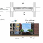
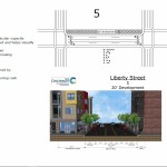
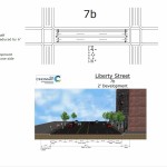
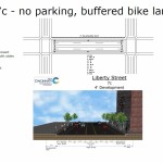
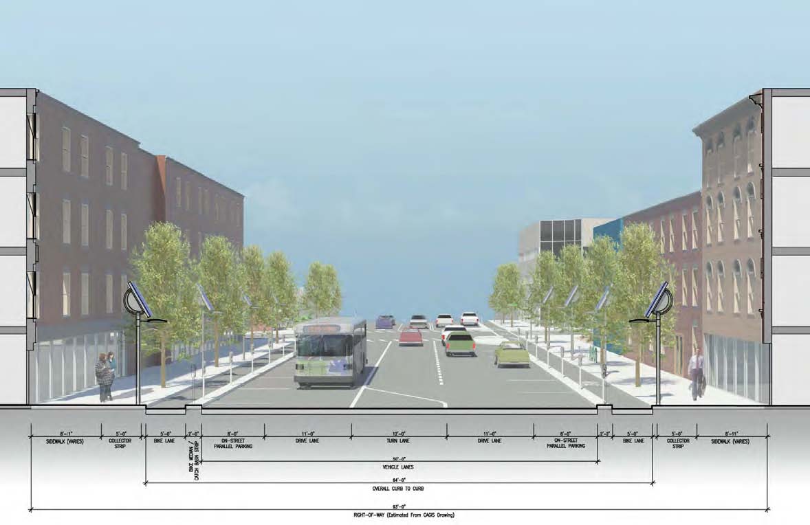
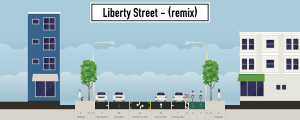
At the meeting, Cincinnati’s Department of Transportation & Engineering will present various concepts for the street’s reconfiguration, including five separate options at seven lanes, and additional six, five, four and three-lane options. Many of these scenarios contribute enough additional space to make development on the south side of Liberty Street feasible.

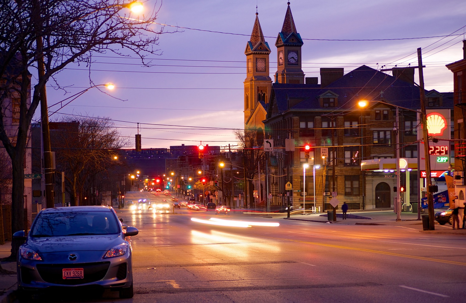
A major consideration, as the project’s title would suggest, is the safety of pedestrians and bicyclists that share the roadway. The current excessive width of the road, coupled with the speed of cars, contributes to an environment incongruous to pedestrian and cyclist safety.

Other elements being considered include pedestrian and cycling facilities, development potential on the south side of Liberty Street, streetscape aesthetics, automobile capacity/safety, and the preservation of on-street parking.

Both current and past public input, like the 2011 Brewery District Master Plan, stress a strong desire to improve the connection of urban fabric between the northern and southern portions of Over-the-Rhine.

“Liberty Street cuts off two sections of OTR,” said Frank Henson, a local cycling advocate. “All other north-south routes get cut up by the expansive width of Liberty; and I support narrowing it, with the inclusion of space for bicycle facilities.”

Many believe that the narrowing of Liberty Street can accomplish both of these objectives; although questions remain about how much narrowing is appropriate, and what should be done with the additional space that is made available.

According to data from the OKI Regional Council of Governments, Liberty Street has an annual average daily traffic (AADT) count of 14,278, which is actually less than the much narrower Ludlow Avenue’s 14,551 AADT in Clifton.

Ludlow Avenue has parking on both sides of the street, aside from peak hours from 7am to 9am where it is prohibited on the south side of the road, and 4pm to 6pm where it is prohibited on the north side of the road. This means that Ludlow Avenue, with its nearly identical traffic count, has fewer lanes of traffic during both peak and non-peak hours.

Martin Luther King Drive, near the University of Cincinnati’s main campus, has the same width as Liberty Street, but carries upwards of 20,000 AADT; and portions of Reading Road carry more than 25,000 AADT with just five lanes.

As a result, one could then deduce that travel demand on Liberty Street is far, far less than its width warrants.

Should Liberty Street be significantly narrowed, based on these figures, it could still absorb its current capacity, and, if necessary, divert traffic to Central Parkway, Fort Washington Way, or one of the many east-west thoroughfares that also have highway access.

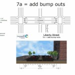
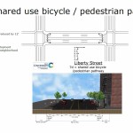
Option 7d includes a “shared use bicycle/pedestrian pathway;” and while this widened path is intended to accommodate both pedestrians and cyclists, it is generally considered a less safe practice, as compared to separate facilities, to mix the two due to the faster travel speeds of people on bicycles.

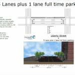
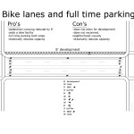
An option that has bike and pedestrian facilities, preserves on-street parking, while also providing three travel lanes could reduce speed, increase safety, provide additional space for development, and still manage capacity based on comparable traffic counts.

The Ludlow Avenue and Reading Road examples disprove the idea that any decrease in capacity would be crippling. However, should demand increase, traffic is also highly divertible to other thoroughfares within a short distance.

Residents and interested parties can express their opinions on Tuesday, March 1 from 6pm to 8pm at the Woodward Theater in Over-the-Rhine. City officials say that they hope to narrow the alternatives to two following this meeting.

Categories
Development News Transportation

Alternatives For Liberty Street Reconfiguration Improvements Vary Widely

Following a public meeting at the Woodward Theater on November 18, Cincinnati’s Department of Transportation and Engineering is asking for feedback on the latest proposed alternatives to potentially narrowing the seven-lane, 70-foot-wide road corridor.

At the meeting, City staff provided drawings for seven alternatives to the existing design. Drawings included configurations for two-, four- and seven-lane configurations of the street, along with commentary on the pros and cons of each.

The two- and four-lane configurations would give a certain amount of space back to property owners along the south side of the street, thus increasing the development potential of some corner lots. Only a few of the seven-lane configurations included bicycle lanes on each side of the street, while others sacrificed some on-street parking to make way for bike lanes.

At the public meeting, neighborhood residents raised concern about the impact of through traffic and trucks on the street. In particular, the concern was that the street is too wide and acts as a barrier for pedestrians.

The Over-the-Rhine Brewery District, which has been the leading group pushing for this project, asked at the public meeting why the reconfiguration developed as part of their Master Plan was not included. After some consideration, City Hall has since added an alternative based on the Brewery District’s concept that included a three-lane road configuration with protected bike lanes on each side.

The proposed narrowing of Liberty Street, which was originally built as a 25-foot-wide neighborhood street, is seen by many as an opportunity to bridge the physical and psychological divide between the northern and southern portions of Over-the-Rhine.

“Minimizing the number of lanes on Liberty Street is important so the neighborhood can take over the streets,” Jean-Francois Flechet, owner of Taste of Belgium, commented after the public meeting. “I think it is important to have development on the south side, but we should also accommodate bicycles.”

Allowing for new development, while also accommodating bicycles and preserving on-street parking seems to be the biggest challenge currently facing the project. At some point, one of the items will have to give.

“I bike on Liberty Street, but I bike everywhere, and the majority of people would not find this comfortable,” Flechet continued. “I have never done it during rush hour, and I cannot imagine this would be any fun.”

City officials are accepting public comment on the various alternatives until Wednesday, December 16. The city has posted the alternatives and a public feedback form has been posted on their website. Once the public comment period is closed, City staff says they will narrow the number of alternatives down to two, and recommend one to proceed to final design.

There is currently no funding identified to implement any of the alternatives, but City officials hope to secure the necessary funds at a later date.


Categories
News Transportation

Could Narrowing Liberty Street Unlock New Development Potential in OTR?

Streets can set the mood and feel of a place. Narrow streets with low traffic are quiet, easy to walk across and casual. Wide streets can be chaotic, full of traffic and hard to bridge on foot. There is a wide street in Over-the-Rhine that cuts through the northern part of the neighborhood and the southern revitalizing part of it. It’s Liberty Street.

Liberty Street was not always so wide. Before 1955 the street, which now dead ends at Reading Road and the I-471 ramps, extended from Highland Avenue on the hill in Mt. Auburn to the U.S. Post Office facility in Queensgate. The width of the street was a modest 25 feet.

In 1955, however, the city decided to widen and connect it to Reading Road as a east-west cross town access point for the interstate highway system. Buildings on the south side of the street were demolished and the street was widened from a two lane road to one with five lanes.

The street is currently 70 feet wide and is both dangerous and difficult to cross for people walking. Development has not taken place on the south side of the street since most of remaining lots are too small and oddly shaped for development.

Beyond its physical barriers, Liberty Street also serves as a psychological barrier between the nascent Brewery District and vibrant Gateway Quarter.

In 2012, the City’s Department of Transportation & Engineering began studying ways to calm traffic on the street in order to make it safer. After spending two years evaluating traffic conditions, City Hall is beginning to engage the public for comment on the proposal. The first will be tomorrow night at the Woodward Theater.

The session will build upon the idea proposed in the OTR Brewery District Master Plan, which called for the removal of a lane of traffic to add protected bicycle lanes in both directions. The UrbanCincy team recently discussed the proposal and found that while this is a good starting point, there is a larger opportunity for the street to spur more redevelopment along the corridor.

Our proposal eliminates one lane of traffic in each direction, but preserves the middle turn lane. A two-way contraflow protected bicycle lane would then be installed on the south side of the street. This leaves approximately 15 feet of unused street right-of-way.

This unused right-of-way could be returned to property owners on the south side of the street, thus narrowing the overall street by 15 feet. It would also increase the size of the southern properties which would increase their development potential and improve safety for pedestrians crossing the street. This would serve as particularly beneficial for small parcels such as those at the corner of Vine and Liberty or between Main and Sycamore.

This idea builds on the ideas put forward by Jeff Speck, who recently released a video on traffic calming and embraces modern street design standards that are found in the National Association of City Transportation Officials Street Design Manual.

The Liberty Street Safety Improvement Open House will take place at the Woodward Theater located at 1404 Main Street in Over-the-Rhine. The session starts at 6pm and will last until 8pm. It is served by the #16, 17, 19 and 24 Metro bus routes, and is less than a block away from a Cincy Red Bike station.