Categories
News Transportation

Second Real-Time Transit App Launches Just Four Months After SORTA Opened Data

Area transit riders can now download a new app called Bus Detective that offers real-time arrival information for Metro bus service.

Developed by locally based Gaslight, the app is free and available for download on Android and iOS devices. The data has also been packaged so that it can be accessed on the web at www.busdetective.com.

For years the Southwest Ohio Regional Transit Authority had been reluctant, like many other transit operators throughout the nation, to open up their data to the public. But just four months after opening the data, the region’s largest transit agency is now the beneficiary of a free real-time bus tracking app.

“It’s all about convenience. Our customers want to know when their bus is coming, real-time,” says Metro CEO Dwight Ferrell. “Smartphones are everywhere, and transit apps like Bus Detective make transit even easier to use.”
The city’s burgeoning tech community had been calling for local leaders to open more data. So far 2015 has proven to be a watershed moment for such actions, particularly so with the launch of Open Data Cincy.

“We’re huge fans of open data and turning that information into something valuable for the public,” says Chris Moore, CEO of Gaslight. “We also love public transportation and hope the app encourages more people to ride the bus.”

A query of the App Store reveals that Cincinnati may be the first transit agency in Ohio with its own custom real-time tracking application; however, both Cincinnati and Cleveland also have had Transit Tracker – an app that has been tailored to more than 30 cities nationwide – since 2014.

Both applications are free to use, but Transit Tracker can be used on the Apple Watch if users purchase an in-app upgrade. It also offers limited interoperability with TANK and Cincy Red Bike.

While Bus Detective has been available for more than two weeks, it officially launched today.

The timing could not be better, as reports show that Metro continues to struggle with stagnant ridership with what industry analysts call choice riders. Apps like these allow for people, who could otherwise opt for a personal automobile or ridesharing services, to more comfortably plan their transit schedules; and thus more likely to ride the bus.

“The Bus Detective app is a great example of the talent and creativity within our community and is helping make catching the bus even easier for the thousands of customers who rely on our service every day,” said Ferrell.

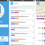
The app is relatively simple to use. Users just need to download the app and then search for their stop by a specific street address or the closest stop to their current location. From there users are presented with the arrival information for the next several buses, and can save specific stops as favorites for quicker reference in the future.

While the app offers clear bus tracking information, it does not allow users to map their trips. This much more complicated function is best carried out by using GoogleMaps, which Metro was added to in 2011 after the agency opened their data to the tech giant.

The Bus Detective launch event will continue on Fountain Square today until 1pm. Those who attend will be able to learn more about the app, while also having the opportunity to win prizes and take selfies with a full-size, sleuthy Metro buses.

Categories
Business News

UrbanCincy Now Listed As Official Google News Provider

Earlier this week we received news that UrbanCincy had been approved by Google reviewers and will now be listed as an official Google News provider. What this means is that UrbanCincy, along with the other more traditional news outlets in Cincinnati, will now have its stories automatically pulled into Google News results.

According to reviewers, “Google News aims to organize all the world’s news and make it accessible to its users, while providing the best possible experience for those seeking useful and timely news information. Our ability to meet these goals depends critically on the quality of the sites included in Google News.”

They go on to say that Google is able to meet those goals by maintaining strict guidelines and standards that help one of the world’s largest technology companies maintain fairness and consistency for website inclusion.

In particular, Google reviewers examine websites by five key metrics – news content, journalistic standards, authority, accountability, and readability. Google’s approval of UrbanCincy validates that we not only produce accurate and authoritative information, but do so in an accountable manner by using real names and providing contact information for our writers and editors.

It also means that you can rely on UrbanCincy for actual news that goes beyond the flood of listicles, how-to articles, advice columns or job postings that are found on so many other websites.

The first story of ours to appear in the Google News listing was our exclusive story yesterday about the plans to thoughtfully redevelop Pleasant Ridge’s business district.

Our eighth year anniversary is quickly approaching, and we hope you will continue to stick with us over the coming months as we roll out a series of changes and improvements to our website, podcast and social media platforms. Thanks for reading.

Categories
Up To Speed

Mapping May Impede Self-Driving Car Development

 Mapping May Impede Self-Driving Car Development 

Urbanists, futurists and car enthusiasts buzz has been building over self-driving car technology. Traffic planners see them as a way to improve traffic flow on congested roadways. However; Slate’s Lee Gomes takes an in-depth look into the technology behind the curtain of the self-driving car and his conclusion is that it’s not ready for prime-time and it may never be ready. More from Slate:

But the maps have problems, starting with the fact that the car can’t travel a single inch without one. Since maps are one of the engineering foundations of the Google car, before the company’s vision for ubiquitous self-driving cars can be realized, all 4 million miles of U.S. public roads will be need to be mapped, plus driveways, off-road trails, and everywhere else you’d ever want to take the car. So far, only a few thousand miles of road have gotten the treatment, most of them around the company’s headquarters in Mountain View, California.  The company frequently says that its car has driven more than 700,000 miles safely, but those are the same few thousand mapped miles, driven over and over again.

Categories
Month in Review

Month in Review – May 2014

Three of UrbanCincy‘s top stories in May revolved around a few dramatic transformations taking place in the urban core. We took you on a Street View tour of some of the biggest transformations in the city, showed you photos of the Cincinnati Streetcar’s construction, and shared news about changes to the city’s oldest historic district. In case you missed them, enjoy UrbanCincy‘s most popular stories from May 2014:

    1. PHOTOS: Cincinnati’s Dramatic, Decade-Long Transformation Visualized
      While many of us can feel that a transformation has taken place in Cincinnati over the past decade, it can be difficult to visualize it. Thanks to new Google Street View capabilities we have done just that.
    2. EDITORIAL: What Cranley’s Clever Budget Means for Urbanists
      The rookie Mayor John Cranley has proposed his first budget. At first glance, it doesn’t look so bad. But after further review what most feared is in fact the sad reality.
    3. The Littlefield to Bring Craft Bourbon Bar to Northside This June
      A craft bourbon bar called The Littlefield will open in Northside next month. The approximately 400SF establishment, which will also include a large outdoor terrace, has been years in the making.
    4. Western & Southern Aiming to Alter Lytle Park Historic District Boundaries
      Western & Southern has long been rumored to be eyeing a location for a new high-rise office tower to consolidate their headquarters; and proposed changes to the Lytle Park Historic District may be setting up for exactly that.
    5. PHOTOS: Construction Activities for $133M Streetcar Project Move Southward
      Significant visual progress continues to be made on the $133M first phase of the Cincinnati Streetcar. Take a look at the progress and learn about a string of good news that may push forward the opening date.


Categories
Development News

PHOTOS: Cincinnati’s Dramatic, Decade-Long Transformation Visualized

The changes that have been taking place in Cincinnati over the past decade have been felt and noticed by many. There is a palpable buzz surrounding the Queen City these days.

The city’s central riverfront has almost entirely been transformed following billions of dollars worth of public and private investment, Over-the-Rhine’s renaissance continues to be touted nation-wide as one to be admired, and thousands of more residential units are being developed in the center city as we speak.

For those who live outside the city and may not have been back recently, or for those out-of-towners who have not yet been able to make a visit, it could be difficult to even recognize some places now.

Thanks to a new feature from Google Street View, we can now go back in time and compare Google’s most current Street View images with those they have taken since 2007 when they started the service.

Here’s a look at some of Cincinnati’s more visually impressive transformations, but it is certainly not all encompassing. Simply drag the arrow bar back-and-forth to compare the old and new images.

Clifton Heights at W. McMillan Avenue and Ohio Avenue:

Clifton Heights in September 2007
Clifton Heights in September 2012


Evanston at Dana Avenue and St. Francis Way (formerly Woodburn Avenue):

Xavier University September 2007
Xavier University August 2012


Over-the-Rhine looking south on Vine Street near Fifteenth Street:

Vine Street September 2007
Vine Street June 2012


Over-the-Rhine looking north on Vine Street near Fourteenth Street:

Vine St September 2007
Vine St June 2012


The Banks at Freedom Way and Walnut Street:

The Banks July 2007
The Banks September 2012


Smale Riverfront Park along Mehring Way at Main Street:

Smale Riverfront Park July 2007
Smale Riverfront Park August 2012


Avondale on Burnet Avenue near Northern Avenue:

Mt. Auburn September 2007
Mt. Auburn June 2012


Columbia Tusculum at Delta Avenue and Columbia Parkway:

Columbia Tusculum August 2007
Columbia Tusculum June 2012


College Hill on Hamilton Avenue near Elkton Place:

College Hill August 2007
College Hill September 2013

If you are having difficultly viewing both the before and after images, try to just drag the arrow bar back-and-forth instead of clicking on the images in an attempt to reveal the after.

And for what it’s worth, we totally stole the idea for this post from The Washington Post. What other areas did we miss? Let us know in the comment section.