Categories
Arts & Entertainment News

Over-the-Rhine Exhibit Offers Place-Based Look At Neighborhood’s Past

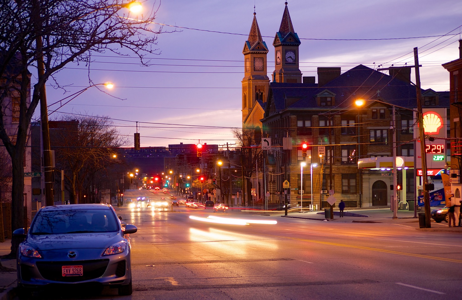
Internet forums often serve as a popular location for people to share historical photos of the cities they love, but a new project from a People’s Liberty grantee is bringing that historical looking glass to the streets of Over-the-Rhine.

Anne Delano Steinert, a doctoral student at the University of Cincinnati studying urban and public history, says that she came up with the idea after enjoying place-based historical projects elsewhere – including Jay Shell’s rap lyrics project in New York City, RepoHistory’s work on Civil Disturbances (1998-1999) and Queer Spaces (1994), and The Museum in the Streets in Hastings-On-Hudson, New York.

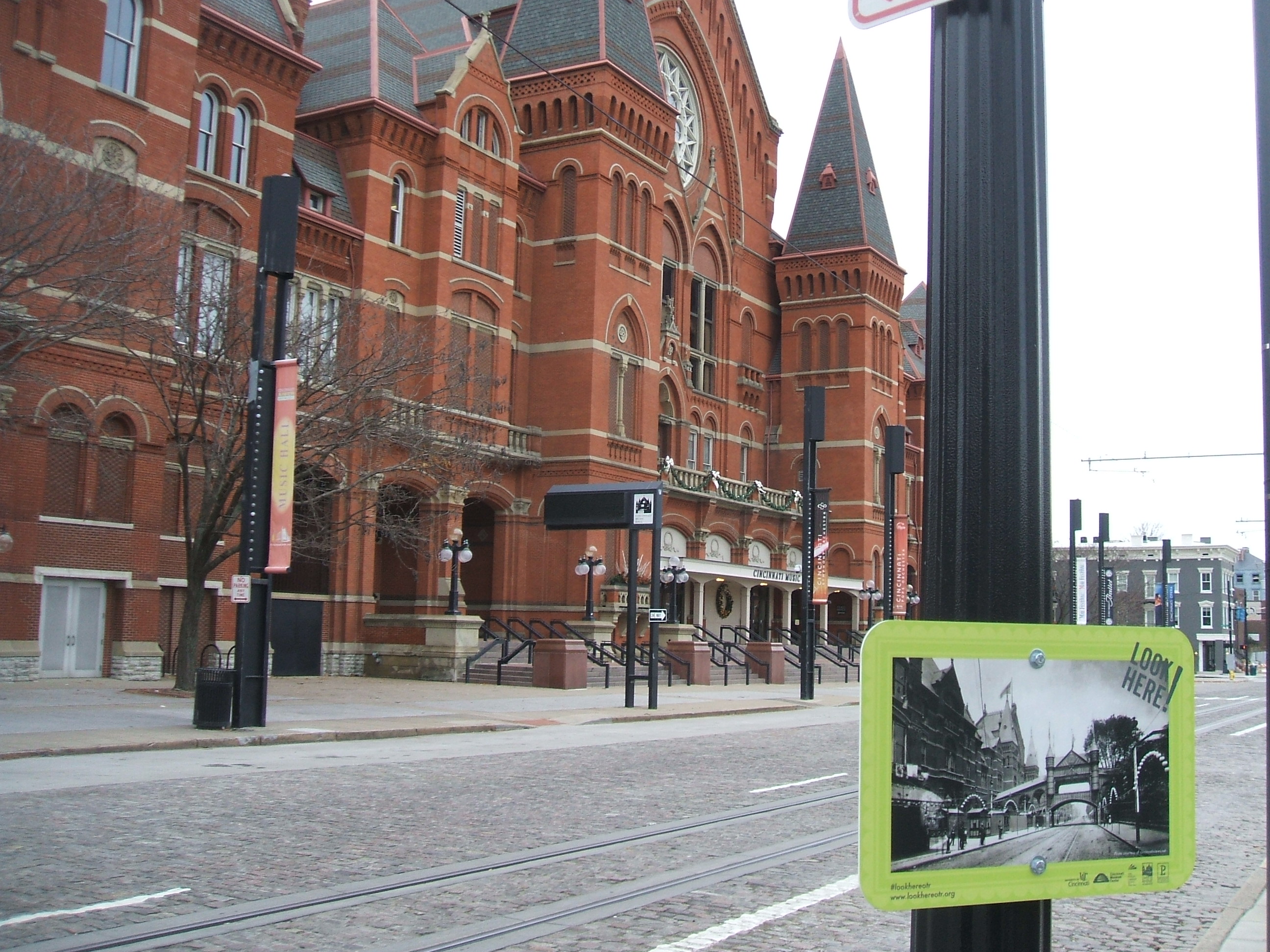
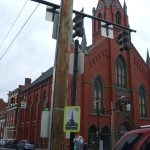
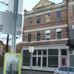
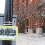
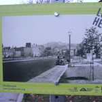
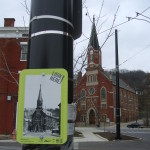
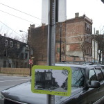
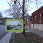
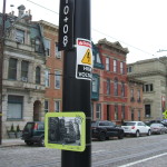
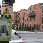
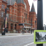
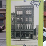
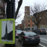
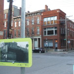
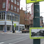
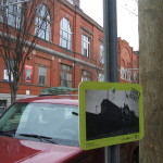
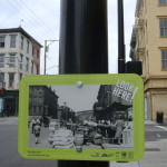
The idea she employs is simple. She posts historical photos in public places to contrast what that view looked like generations ago. Her initial effort has focused on Over-the-Rhine, but has the possibility of expanding to other places depending on funding and demand.

The project, called Look Here!, is already offering a refreshing analog experience in a city so often defined by tech and digital communications. It is even more beneficial due to the fact that it is equally available for all to experience, regardless of income or access to technology.

“I strongly believe that all of us, regardless of age, class, or training have the ability to read the built environment as a way to enrich our understanding of the past,” Steinert explains. “As a result, I have chosen to post only historic photographs without informational text. The exhibit relies on you to read the photographs, ask questions and make meaning for yourself.”

Steinert says that she hopes this exploration leads people to conduct their own additional exploration and research. She also hopes that it serves as a bridge between the established residents of the historical neighborhood, and the many newcomers.

“The rapid change happening in Over-the-Rhine makes it an ideal location for the exhibit,” Steinert says. “As buildings are rehabilitated and new users join long-established residents, it is important to root the present in an understanding of the past. As the neighborhood evolves, this exhibition will allow Cincinnatians to make connections between the past and the present.”

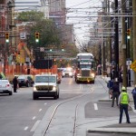
The 69 exhibits positioned throughout Over-the-Rhine are planned to stay in place through March 2016.

EDITORIAL NOTE: All 17 photographs were taken by Eric Anspach for UrbanCincy in December 2015.

Categories
Development News Transportation

Alternatives For Liberty Street Reconfiguration Improvements Vary Widely

Following a public meeting at the Woodward Theater on November 18, Cincinnati’s Department of Transportation and Engineering is asking for feedback on the latest proposed alternatives to potentially narrowing the seven-lane, 70-foot-wide road corridor.

At the meeting, City staff provided drawings for seven alternatives to the existing design. Drawings included configurations for two-, four- and seven-lane configurations of the street, along with commentary on the pros and cons of each.

The two- and four-lane configurations would give a certain amount of space back to property owners along the south side of the street, thus increasing the development potential of some corner lots. Only a few of the seven-lane configurations included bicycle lanes on each side of the street, while others sacrificed some on-street parking to make way for bike lanes.

At the public meeting, neighborhood residents raised concern about the impact of through traffic and trucks on the street. In particular, the concern was that the street is too wide and acts as a barrier for pedestrians.

The Over-the-Rhine Brewery District, which has been the leading group pushing for this project, asked at the public meeting why the reconfiguration developed as part of their Master Plan was not included. After some consideration, City Hall has since added an alternative based on the Brewery District’s concept that included a three-lane road configuration with protected bike lanes on each side.

The proposed narrowing of Liberty Street, which was originally built as a 25-foot-wide neighborhood street, is seen by many as an opportunity to bridge the physical and psychological divide between the northern and southern portions of Over-the-Rhine.

“Minimizing the number of lanes on Liberty Street is important so the neighborhood can take over the streets,” Jean-Francois Flechet, owner of Taste of Belgium, commented after the public meeting. “I think it is important to have development on the south side, but we should also accommodate bicycles.”

Allowing for new development, while also accommodating bicycles and preserving on-street parking seems to be the biggest challenge currently facing the project. At some point, one of the items will have to give.

“I bike on Liberty Street, but I bike everywhere, and the majority of people would not find this comfortable,” Flechet continued. “I have never done it during rush hour, and I cannot imagine this would be any fun.”

City officials are accepting public comment on the various alternatives until Wednesday, December 16. The city has posted the alternatives and a public feedback form has been posted on their website. Once the public comment period is closed, City staff says they will narrow the number of alternatives down to two, and recommend one to proceed to final design.

There is currently no funding identified to implement any of the alternatives, but City officials hope to secure the necessary funds at a later date.


Categories
News Transportation

Could Narrowing Liberty Street Unlock New Development Potential in OTR?

Streets can set the mood and feel of a place. Narrow streets with low traffic are quiet, easy to walk across and casual. Wide streets can be chaotic, full of traffic and hard to bridge on foot. There is a wide street in Over-the-Rhine that cuts through the northern part of the neighborhood and the southern revitalizing part of it. It’s Liberty Street.

Liberty Street was not always so wide. Before 1955 the street, which now dead ends at Reading Road and the I-471 ramps, extended from Highland Avenue on the hill in Mt. Auburn to the U.S. Post Office facility in Queensgate. The width of the street was a modest 25 feet.

In 1955, however, the city decided to widen and connect it to Reading Road as a east-west cross town access point for the interstate highway system. Buildings on the south side of the street were demolished and the street was widened from a two lane road to one with five lanes.

The street is currently 70 feet wide and is both dangerous and difficult to cross for people walking. Development has not taken place on the south side of the street since most of remaining lots are too small and oddly shaped for development.

Beyond its physical barriers, Liberty Street also serves as a psychological barrier between the nascent Brewery District and vibrant Gateway Quarter.

In 2012, the City’s Department of Transportation & Engineering began studying ways to calm traffic on the street in order to make it safer. After spending two years evaluating traffic conditions, City Hall is beginning to engage the public for comment on the proposal. The first will be tomorrow night at the Woodward Theater.

The session will build upon the idea proposed in the OTR Brewery District Master Plan, which called for the removal of a lane of traffic to add protected bicycle lanes in both directions. The UrbanCincy team recently discussed the proposal and found that while this is a good starting point, there is a larger opportunity for the street to spur more redevelopment along the corridor.

Our proposal eliminates one lane of traffic in each direction, but preserves the middle turn lane. A two-way contraflow protected bicycle lane would then be installed on the south side of the street. This leaves approximately 15 feet of unused street right-of-way.

This unused right-of-way could be returned to property owners on the south side of the street, thus narrowing the overall street by 15 feet. It would also increase the size of the southern properties which would increase their development potential and improve safety for pedestrians crossing the street. This would serve as particularly beneficial for small parcels such as those at the corner of Vine and Liberty or between Main and Sycamore.

This idea builds on the ideas put forward by Jeff Speck, who recently released a video on traffic calming and embraces modern street design standards that are found in the National Association of City Transportation Officials Street Design Manual.

The Liberty Street Safety Improvement Open House will take place at the Woodward Theater located at 1404 Main Street in Over-the-Rhine. The session starts at 6pm and will last until 8pm. It is served by the #16, 17, 19 and 24 Metro bus routes, and is less than a block away from a Cincy Red Bike station.

Categories
News Transportation

PHOTOS: Cincinnati’s First Modern Streetcar Arrives in Over-the-Rhine

On Friday, October 30, Cincinnati’s first modern streetcar vehicle arrived at the Maintenance and Operations Facility in Over-the-Rhine.

A crowd was gathered on Race Street as Cincinnati Streetcar #1175, which continues the numbering system Metro used for its streetcars when they went out of service decades ago, arrived on the back of a flatbed truck and was carefully lowered onto the track and towed into the building.

The most common reaction overheard from the crowd was, “It’s big!” While renderings of the streetcar have been available online, many people will be surprised when they see the streetcars in person. Each vehicle can hold 150 passengers, about three times more than a bus.

The remaining four streetcars are expected to arrive in Cincinnati by February 5, 2016. Each vehicle must be thoroughly tested before allowing passengers on board, so don’t be surprised if you see streetcars throughout Downtown and Over-the-Rhine over the next several months.

The system is still expected to open to passengers in September 2016.

These 14 photos were taken by Travis Estell and John Yung for UrbanCincy.

Categories
News Transportation

VIDEO: The Easy and Inexpensive Way For Cincinnati To Make Its Streets Safer

Anyone who rides a bicycle to work, either their own or on a Cincy Red Bike, knows all to well the commute mostly involves sharing the road with automobiles. With the current city administration focusing more on creating recreational trails for bicycle hobbyists, cyclists who bike as a form of transportation can only daydream about better on-street bicycle infrastructure.

That daydream could come closer to reality with the release of a new animation from planner and author Jeff Speck.

An accomplished author of books such as Walkable City and Suburban Nation, Speck describes four simple street reconfiguration options that would better accommodate all modes of transportation without adding to the roadway’s width. In order to accomplish that, the techniques include narrowing lanes, adding striped or buffered bike lanes.

Planners and engineers have found that such changes have a minimal impact on the flow of vehicular traffic, by adding only seconds onto commute times.

The street in the video is 38 to 40 feet in width, which is just about the average width of many streets throughout Cincinnati. In fact, UrbanCincy proposed a similar reconfiguration of Elm Street through the Central Business District in 2013. Such transformations have been noted to positively impact safety.

“Such a change on Prospect Park West in Brooklyn reduced speeding by 77% and reduced injury crashes by 63%, while having no impact on car volume or travel times,” Speck noted in the video.

When Randy Simes first wrote about the Elm Street reconfiguration, he explained that it would also serve as a critical connection point between the protected bike lane on Central Parkway and the Ohio River Trail. While Elm Street is a particularly obvious choice, other streets throughout the city could and should get some of the same treatment.

One another prominent example is Liberty Street, which Cincinnati’s Department of Transportation & Engineering has been looking at for years as a potential road diet candidate. Originally designed for much higher traffic volumes that were never realized, Liberty Street’s 70-foot width now functions more as a safety issue for people walking or biking, and as a barrier between the northern and southern portions of Over-the-Rhine.

Those plans for Liberty Street were originally envisioned by the Over-the-Rhine Brewery District, which then convinced City Hall to perform some planning work. At this time, however, the project does not appear to be moving forward.

Speck’s video makes it easy to see that for the cost of paint it would be relatively easy to install a more comprehensive bike network on streets throughout the city. Such changes would improve safety, increase the number of people riding bikes, which probably means more Red Bike usage, all while slowing down traffic just a tiny bit. Besides, even automobile drivers may appreciate not needing to directly interact with so many bicycles on the street.