Categories
Development News Transportation

Cincinnati Aims to Break Ground on Next Phase of Ohio River Trail in June 2017

City officials are advancing the designs for the next phase of the Ohio River Trail. The 2.2-mile segment will run from Salem Road to Sutton Road in Cincinnati’s California neighborhood on its eastern riverfront.

Project and community leaders are excited about the work because it will fill in a gap in the Ohio River Trail that will eventually stretch 23 miles from Coney Island on the east to Sayler Park on the west. The project will also represent an approximate 50% increase in the number of completed miles of the Ohio River Trail.

While designs are still being finalized, city officials presented a conceptual design and the preferred alignment with the public at an open house held on March 25.

The designs call for a shared use, asphalt path for bicyclists and pedestrians that is 12 feet wide. There would be a six-foot setback from the road, and the path would essentially function as an extra wide sidewalk in order to avoid taking any right-of-way away from automobiles.

The preferred alignment for the shared trail would run along the eastern side of Kellogg Avenue and go through the California Woods Nature Preserve. The pathway would pass underneath I-275 at the foot of the Combs-Hehl Bridge.

Project officials say that they will take feedback given during the recent open house into consideration when developing final designs, and formulate construction cost estimates. The next public meeting will take place in October.

If all goes according to plan, detailed design work will be complete by October 2016 and construction will begin in June 2017.

Categories
Business Development News Transportation

Dayton Secures $1M in Capital Funding to Launch Bike Share System in Spring 2015

Dayton Bike Share MapThe City of Dayton, in collaboration with Bike Miami Valley, Downtown Dayton Partnership and the Miami Valley Regional Planning Commission (MVRPC), plans to start a bike share program in the spring of 2015.

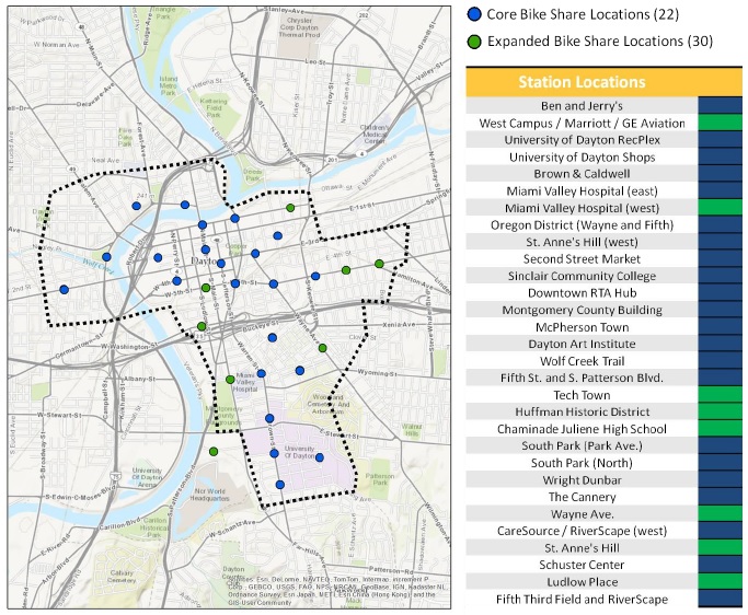
The system will operate similarly to Cincinnati’s planned bike share system announced this past February. The main difference between the two, however, is that Dayton has secured $1 million in capital funding to build out the initial system of more than 200 bikes and 22 stations located throughout Dayton’s center city.

According to city officials, the bulk of the capital funding will come from a grant from the Federal Highway Administration Surface Transportation Program. The City of Dayton will then provide an additional $250,000 funding for capital costs and initial operations.

The accomplishment of securing the capital funding was one not lost on those at the press conference. Scott Murphy, director of business development at the Downtown Dayton Partnership, emphasized that Dayton is the second city in Ohio to secure the capital for a bike share program.

Even though Cincinnati officials have yet to secure the capital funding for their planned bike share system, they remain optimistic they can do so and start operations in 2014 – ahead of Dayton’s planned launch early next year.

Also unlike Cincinnati where a non-profit entity will manage the system, the Greater Dayton Regional Transit Authority will take the lead in managing the program, and in selecting an operator. According to Executive Director Mark Donaghy, a request for proposals will be issued in the next three months, and an operating contract will be awarded this summer.

Dayton officials estimate that the infrastructure will be delivered this coming winter, with the program becoming operational in the months thereafter. Bike Miami Valley, a local cycling advocacy group, spurred the whole effort to bring bike share to Dayton with the preparation of a feasibility study.

Findings of the study indicated that Dayton has a higher level of suitability for a program than some similarly sized cities that already have bike share, such as San Antonio, Chattanooga and Madison, WI. The study also estimated that Dayton’s system would handle approximately 50,000 to 70,000 annual bike share trips.

Local leaders are giving the program enthusiastic support.

“Bike share is a natural extension of our transit system,” stated Donaghy, who went on to say that the RTA was the first transit system in Ohio to equip its full fleet of buses with bicycle racks.

Such efforts to embrace bicycling have made Dayton a bronze level Bicycle Friendly Community, as rated by the League of American Bicyclists. Community leaders in Dayton, however, intend to become reach the platinum rating by 2020.

Brian Martin, Executive Director of MVRPC, stated that the program will expand and enhance existing services of the Regional Transit Authority, while also helping reduce auto dependency. In part due to the study conducted by Bike Miami Valley, and the tangible changes taking place in Dayton’s center city, local leaders say they knew this was the right decision.

“The number of housing units in downtown Dayton has doubled in the last 10 years,” Dayton Mayor Nan Whaley told UrbanCincy. “We know this is what people want.”

Categories
News Transportation

Snow Accumulation Highlights Cincinnati’s Over-Engineered Streets through ‘Sneckdowns’

Our streets sometimes seem to be over-engineered. Their capacities are designed for peak usage, turning radii for the largest trucks, and speeds for the fastest movement. For the easy movement of cars and trucks this may be good, but for everyone else it is dangerous and less livable.

To combat such situations, many communities across the United States have begun building curb extension to help slow down traffic and make the public right-of-way more hospitable for everyone who is not in either a car or truck. Some people call these curb extensions, and similar improvements, neckdowns.

While most of our streets have not been improved in such a way, it becomes easy to see how and where neckdowns could be placed when it snows. This is because only the areas of the road that are used become cleared. The rest stay covered in snow and are a very obvious display of the aforementioned over-engineering.

During the city’s last snow event, the UrbanCincy team took to social media and asked Cincinnatians to submit photos of area sneckdowns – snowmade neckdowns. If you see any around your neighborhood make sure you take a shot of it and send it to editors@urbancincy.com, tweet us @UrbanCincy, or upload your photos in the comment section of this story.

Categories
Development News Transportation

VIDEO: Are ‘Protected Intersections’ the Next Bicycle Infrastructure Innovation?

The City of Cincinnati and other area municipalities have been working to improve the region’s bicycle infrastructure in order to both make cycling more attractive and safer. Those improvements have included new bike lanes, sharrows, cycle tracks, trails and dedicated parking for bikes.

City officials say that protected bike lanes, like the cycle tracks to be installed along Central Parkway, offer the larger population an incentive to get out on their bicycles. Those officials point to results from public polling that show large percentages of people that would be open to riding bikes if they felt safer on the roads, and that protected bike lanes would do wonders to accomplishing that.

But Nick Falbo, an urban planner and designer at Alta Planning+Design, thinks protected bike lanes aren’t enough.

“Protected bike lanes lose their benefits when they reach intersections,” Falbo states in his six-minute-long video proposal. “The buffer falls away and you’re faced with an ambiguous collection of green paint, dashed lines and bicycle markings.”

In his submission to the George Mason University 2014 Cameron Rian Hays Outside the Box Competition, Falbo proposes what he calls the Protected Intersection – a design overhaul for intersections that he says will not only improve the value and safety of protected bike lanes, but also make the intersection more usable for all modes of traffic.

“It doesn’t matter how safe and protected your bike lane is, if intersections are risky, stressful experiences. We need to make intersections just as safe and secure as the lanes that lead into them. What the protected bike lane needs is a protected intersection.”

Categories
Development News Transportation

Elm Street Cycle Track Would Provide Critical Link for Region’s Bike Infrastructure

The city will start construction on physically separated bike lanes along Central Parkway, from Downtown to Clifton, this coming spring. Following a community engagement process, a final design was selected in recent weeks, and the large addition to Cincinnati’s bike network is expected to make a significant impact.

Not only will it be one of the most impressive bike facilities installed in the region to-date, but it will also link neighborhoods together that have large percentages of bicyclists. Furthermore, it will link other bike facilities with one another, and come close to linking even more.

Some of the existing facilities include numerous bike lanes and the Mill Creek Greenway, but the Central Parkway bike lanes will come about 12 blocks shy of connecting with the Ohio River Trail, which then links to the Little Miami Scenic Trail.

A two-way cycle track should be built in order to connect the new Central Parkway bike lanes with the Ohio River Trail and beyond.

Elm Street Cycle Track

There are two streets that connect from Central Parkway to the Ohio River Trail along Mehring Way without interruption: Main Street and Elm Street. Both of the streets have one-way traffic heading northbound, but Main Street is considerably more congested with cars and buses heading to Government Square.

Elm Street, however, has some of the least congestion of any north/south street in the Central Business District and could easily connect the Central Parkway cycle track with the Ohio River Trail. A reorganization of the street would need to occur however.

Presently Elm Street, from Central Parkway to Mehring Way, lacks consistency in its design with on-street parking located haphazardly along both sides of the street. A reconfiguration of the street could consolidate all on-street parking to the east side of the street, thus eliminating only a nominal number of on-street parking spaces, and maintain 2 to 3 moving traffic lanes (the parking lane could be restricted during rush hours to allow for a third travel lane).

The Elm Street cycle track, meanwhile, would be located along the west side of the street and be buffered from moving traffic by a row of bollards. Such a redesign of Elm Street would be a bit of a road diet, but one that seems reasonable for this stretch of overbuilt roadway.

Planners with the City’s Department of Transportation & Engineering (DOTE) said that the idea of an Elm Street cycle track had not come up before, and has not been presented to any formal committees or community councils to-date. Such coordination, they say, would need to take place prior to the idea moving forward.

With future phases of The Banks and the yet-to-be-named residential tower on Fourth Street set to begin construction soon, there seems to be an opportunity to rebuild this roadway along with those projects. This would help offset some of the costs and make for a more seamless transition.

Projects like this are low-hanging fruit for the new mayor and council, should they wish to pursue investments that improve the city’s bike infrastructure. They should work with the bike community and come up with a strategy that provides a clear path forward to make this happen.

An Elm Street cycle track like this would provide a critical link in the region’s bike network, make the street safer, more accommodating to more users and more attractive to those who currently find themselves along the now bleak and desolate stretch of roadway. Let’s get to work.