Categories
Development News Transportation

Unraveling the urban differences between Cincinnati and Chicago

I am a native of the Greater Cincinnati area, but I have spent the better part of my adult life living and working in Chicago. I left Chicago in 2007 for greener pastures in New York City, and then ultimately found my way back home to Cincinnati earlier this year. However, I still look back on my time in Chicago as having an enormous impact on my thoughts about urban planning and design, architecture, and mass transit.

In June of this year, and after a long absence, I spent my first weekend in Chicago since becoming involved in discussions about Cincinnati’s ongoing urban renaissance. Once I arrived in town, I could not help but look at my old stomping grounds in a whole new light, and see Chicago’s urban development through the eyes of a born-again Cincinnatian. Over the course of a few days, I was able to explore a few key differences between the two cities, and perhaps come home with a few insights that can be applied to Cincinnati.

Urban Form:
The first and most obvious difference between Cincinnati and Chicago is one of sheer scale. While driving through Indiana on the way to Chicago from Cincinnati, the transition from rural cornfields to suburban sprawl (and its inevitable traffic jams) began while I was still a good 40 miles away from the Chicago Loop. Here in Cincinnati, 40 miles in any direction from Fountain Square would be considered far into the hinterland. Indeed, it is possible to find oneself in a relatively rural area in less than five miles from downtown Cincinnati, depending on the direction of travel.

Topography plays a large role, of course: the Cincinnati area’s steep hills prevent large-scale development in many areas, while the vast plains surrounding Chicago offer no such limitations. I see this as an advantage in Cincinnati’s favor: In addition to providing unique vistas and hillside neighborhoods that Chicagoans could only dream about, Cincinnati’s geographic setting allows for an easy escape to the country without having to drive through 40 miles of strip malls and traffic congestion (assuming one isn’t trying to escape via I-75 or I-71).

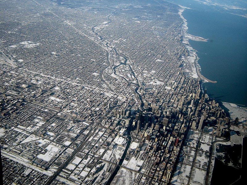
Chicago’s scale is apparent when flying into either of the city’s two airports, especially at night. Chicago’s relentless street grid stretches from horizon to horizon, with the radial streets and freeways all leading to the mountain of skyscrapers downtown. The city’s magnificent lakefront parks form an elegant transition from dense urban neighborhoods to the empty expanse of Lake Michigan. The entire city — so orderly and logical from above, like a circuit board — has the appearance of a vast machine. Down on the surface, though, the machine-like efficiency of the street grid leaves little room for quirks and eccentricities such as Cincinnati’s Mt. Lookout Square or O’Bryonville.

Commercial Districts:
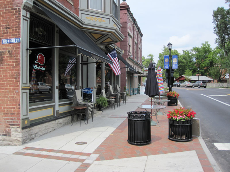
Aaron Renn recently wrote a thought-provoking article about how cities treat their ordinary spaces versus their special spaces, and I believe Cincinnati has the edge in this regard. We don’t have the “special spaces” that Chicago has, such as a Magnificent Mile or a Grant Park (although that is changing for the better as Cincinnati develops its riverfront), but we have a vast number of unique “ordinary spaces” that each have their own character. For example, Chicago’s neighborhood business districts tend to be linear corridors along straight commercial streets, with relatively little distinction from each other. Aside from the makeup of the retail establishments, the urban space of Broadway in Lakeview isn’t much different from that of Milwaukee Avenue in Wicker Park or of Lawrence Avenue in Albany Park. Here in Cincinnati, even if you disregard the types of businesses that occupy the storefronts, there is a real difference between neighborhood business districts such as Ludlow Avenue, Hyde Park Square, and Over-the-Rhine.

Speaking of Over-the-Rhine, there is simply nothing like it in Chicago, as OTR was a bustling urban neighborhood when Chicago was still a remote trading post. Chicago’s present form didn’t come into being until after the Great Chicago Fire, by which time many buildings in Over-the-Rhine were already a generation old. For an urban neighborhood that comes close to resembling Over-the-Rhine, one must look east to New York or Philadelphia rather than west to Chicago.

Residential Neighborhoods:
If Chicago’s commercial avenues are rather drab, that city’s residential side streets offer many lessons for Cincinnati. Upon taking a turn down a leafy side street in Chicago, a pedestrian immediately enters a lush, green world where the noise of the city fades away and the harshness of the sunlight is filtered out by a dense canopy of trees, usually flanked by ornate row houses, bungalows, or apartment buildings. The importance of greenery cannot be understated, and as Over-the-Rhine continues its rejuvenation, Chicago shows that when it comes to street trees, there’s really no such thing as too many. It’s no coincidence that OTR’s Orchard Street — arguably the greenest street in the neighborhood — is also one of the most sought-after streets for renters and homebuyers.

Cincinnati’s dominant grocery store chain could also learn a thing or two from Chicago’s two largest chains on how to design and operate “big box” grocery stores that add life to urban business districts, rather than suck life from them. Throughout Chicago’s denser neighborhoods, Dominick’s (a division of Safeway) and Jewel (a division of Albertson’s) are building stores that place the main entrance at the corner of the building, facing a busy intersection, rather than behind an ocean of parking. In many cases, the stores are multi-story affairs with residential or commercial space above, and parking in a garage tucked around the corner.

An urban-scaled Dominick’s Store in Lincoln Park

One of the first such stores is a Dominick’s location at the corner of Fullerton and Sheffield, adjacent to a CTA rapid transit station and DePaul University. The ground floor of the store contains a deli, butcher and seafood department, florist, bakery, a Starbucks, and the checkout lanes, while the second floor contains aisles of groceries and general merchandise. Large-capacity elevators allow customers to transport strollers and shopping carts between the floors.

Up in my old neighborhood of Edgewater, a Dominick’s store at the corner of Foster and Sheridan — an older suburban-style store not unlike the Kroger store in Corryville — is being replaced with a modern store that respects the neighborhood rather than turning its back on it. If Kroger’s two largest national competitors, Safeway and Albertson’s, are tripping over each other to build urban-scaled grocery stores in dense neighborhoods, then Kroger’s claim that there is no market for such stores would seem to ring hollow.

Public Transit:
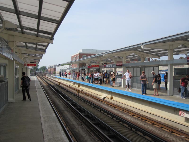
Another key difference between Cincinnati and Chicago that cannot be ignored is public transit. While Chicago’s system of public transit is not perfect by any stretch, Chicago has a culture in which taking a train to work or for shopping is simply accepted as a routine fact of life for most people, rather than as something that is done only because one has no other choice. There is no stigma, and a wide variety of demographic groups can be found represented on the city’s buses and trains on any given day. Regrettably, only a handful of American cities have achieved this, and Cincinnati is not yet one of them. To its credit, the Chicago Transit Authority has recently completed an ambitious upgrade of many stations on the city’s north side and west side, with further upgrades elsewhere in the city underway.

The newly-renovated CTA rapid transit station in Lincoln Park

Finally, and perhaps most importantly, is the difference in general attitude between the two cities. Chicago has a certain swagger that Cincinnati lacks, a confidence among the populace that the city is capable of doing great things and attracting great people. This is a double-edged sword, in that Chicago’s reputation of being “the city that works” involves a strong-man mayor who has almost unlimited powers, who can easily crush any community opposition to his plans.

Indeed, while certain Chicago neighborhoods are high-priced hotbeds for economic development, vast parts of the city continue to look as if they were imported from Detroit. There is also the corruption: In Cincinnati, it would be almost unthinkable for a City Council member or department head to be hauled away in handcuffs by the FBI and indicted on federal corruption charges. In Chicago, such occurrences happen often enough that they barely even make the local news.

Cincinnati, on the other hand, has a long-standing inferiority complex that has proven difficult to shake. But as major projects such as the streetcar, The Banks, and Central Riverfront Park are completed, perhaps Cincinnati will adopt a unique swagger of its own, while avoiding some of the pitfalls of our younger and larger neighbor to the north.

Categories
Development News Transportation

Streetscape projects helping transform Fort Thomas business district

The bedroom suburb of Fort Thomas, Kentucky is perhaps best known for its streets of tidy, well-kept houses and its nationally-ranked public schools. Located along a ridge overlooking the Ohio River and downtown Cincinnati, Fort Thomas is an attractive destination for those seeking the relative peace and quiet of a suburban lifestyle, combined with convenient access to downtown Cincinnati along with walkable streets and plenty of historic character.

In recent years, Fort Thomas has become one of several Northern Kentucky cities seeking to enhance its appeal by revitalizing its historic retail district and rediscovering the benefits of pedestrian-scaled, transit-friendly urban development. Fort Thomas’s neighbor to the north, Bellevue, has received recognition for its ongoing historic preservation work, and Bellevue and Covington have both made strides in implementing form-based codes that could ultimately serve as a model for zoning code changes in Cincinnati.

Over the past few years, Fort Thomas has undertaken a number of projects to enhance the city’s role as an attractive community within Cincinnati’s urban core. These projects include new buildings for Highlands Middle School and Woodfill Elementary School, a new amphitheater and bike trails in Tower Park, and the restoration of the city’s iconic 100-foot-tall stone water tower at the entrance to Tower Park. Perhaps most visibly, though, the city of Fort Thomas has recently completed major streetscaping improvements to its primary business district centered around the intersection of Highland and Fort Thomas Avenues and its secondary business district — the so-called Midway district — located adjacent to the site of the former Army post.

Aspects of the two streetscaping projects included burying overhead utility lines, the reconstruction of sidewalks and crosswalks to include brick accents and other decorative elements, the addition of street trees and thoughtful landscaping, installation of pedestrian-scaled light fixtures and signage, as well as the introduction of benches and other outdoor seating. The first phase to be completed was the primary downtown district at Highland Avenue and Fort Thomas Avenue.

Now complete for a couple of years, the trees and plantings in downtown Fort Thomas have begun to nicely mature. Of particular interest is the focus on the former Green Line streetcar, which provided transit access to the Army post and served as a catalyst for much of the subsequent development in the city from the 1890’s through the 1950’s. Fort Thomas is the classic “streetcar suburb”, and today’s TANK bus route through town still carries the Green Line’s old #11 route number.

Following the completion of streetscaping improvements to the downtown district of Fort Thomas, the second phase involved similar improvements to the so-called Midway district, a secondary business district on South Fort Thomas Avenue that grew up adjacent to the former Army post and was named after the carnival midway at the 1893 World Columbian Exposition in Chicago. The site of the Army post — originally built to replace the flood-prone Newport Barracks — is now home to Tower Park, a large Veterans Administration nursing home, and an Army reserve center.

The streetscaping improvements recently completed in the Midway district are similar in nature to those performed in downtown Fort Thomas. Included in the Midway improvements were the reconfiguration of the River Road intersection, which now provides a small civic space that can be used for outdoor concerts or a farmer’s market, and the addition of sidewalk seating for neighborhood establishments such as the Olde Fort Pub and the Midway Cafe.

There are still a number of vacant storefronts in the Midway district, but it is hoped that the now-completed streetscaping improvements along with other measures, such as the restoration of long-vacant officers’ housing nearby and marketing efforts by the newly-formed Renaissance District, will see the addition of new retail tenants to the Midway district.

Categories
Development News Politics Transportation

Cincinnati’s 3C Dilemma: The Way Forward

One day in 1934, New York mayor Fiorello La Guardia was on a TWA flight back home from Chicago, and his ticket indicated New York as the plane’s final destination. However, the plane landed in Newark, New Jersey, as that was the only airport in the New York region open to commercial aviation at the time. The stubborn mayor refused to get off the plane in Newark, insisting that he be brought to the city indicated on his ticket. “Newark is not New York,” he exclaimed. His flight ultimately continued to Floyd Bennett Field in Brooklyn, and when the plane landed, the mayor — never willing to let a juicy PR moment go to waste — hosted an impromptu press conference to reporters about New York City’s need for its own airport. Within five years, an airport would be built in Queens that would bear Mayor LaGuardia’s name.

A great deal of virtual ink has been expended in recent months regarding the proposed 3C passenger rail line that will link Ohio’s three largest cities and serve as the foundation for future development of a true high-speed rail line across the state. In regards to the station location for the Cincinnati end of the 3C line, we face a dilemma not unlike the one Mayor LaGuardia faced in New York. If the rail line ends in Sharonville, does the 3C line really serve one of its three namesake C’s? Will there come a day when Mayor Mallory refuses to exit the train at Sharonville, insisting that it continue all the way into the city limits of Cincinnati?

There is nothing inherently wrong with having an intermediate 3C station at Sharonville, as it would provide convenient service to suburban riders in much the same way the Route 128 station on the Northeast Corridor gives Boston-area Amtrak passengers a way to avoid having to travel all the way to Back Bay or South Station in order to catch a train going the opposite direction. Assuming we want the 3C service to actually serve Cincinnati, though, the question then becomes: Where does the train go once it goes south of Sharonville?

Previous generations of Cincinnatians blessed us with a magnificent train station in the form of the Union Terminal complex, which opened for passenger service the year before Mayor LaGuardia’s famous outburst in Newark. As one of the most architecturally-significant train stations in the world, and located within a short distance of downtown, Union Terminal is the natural place to terminate the 3C line. The station is already served by Amtrak’s Cardinal three times a week in each direction between New York and Chicago, and has the facilities needed to serve intercity rail passengers such as a waiting room, ticketing office, baggage service, restrooms, etc. In time, Union Terminal could also easily accommodate additional passenger facilities such as expanded restaurant options, car rental facilities, and a streetcar or light rail connection to rest of the city. Indeed, there is near-universal agreement that in the long term, Union Terminal should once again fulfill its proper role as a stunning gateway to Cincinnati for rail passengers.

In the short term, however, 3C service at Union Terminal faces a number of logistical hurdles. Although the station once boasted the capacity to serve 216 trains per day (108 inbound and 108 outbound), Union Terminal’s current capacity is severely reduced. The Southern Railway demolished the passenger concourse and platforms in 1974 in order to accommodate double-stacked freight trains. Many of the station’s former passenger facilities, especially the concentric ramps used to provide bus and taxi access to the station, are now home to the Cincinnati History Museum and the Museum of Natural History and Science. Most crucially, the railroad tracks that serve Union Terminal through the Mill Creek Valley from the north are heavily congested with freight traffic during most hours of the day and night, and lack the capacity for frequent passenger service. Mitigating these limitations is certainly doable with the right amount of money and creative thinking, but doing so will require several years of planning and construction, and isn’t something that’s likely to happen during the first few years of 3C service.

With that in mind, attention shifts to the location of a temporary station that will serve the city until the capacity issues at Union Terminal can be resolved. Here are a few of the most likely options that have been put forward.

Entrance to the Riverfront Transit Center on 2nd Street

Riverfront Transit Center
Located under Second Street along the downtown riverfront, the Riverfront Transit Center (RTC) was created out of space left over from the reconstruction of the adjacent Fort Washington Way in 2002. Rather than spend the considerable money it would take to fill in the space with dirt, planners wisely decided to create a space that could one day be used for some form of passenger rail service. (In the meantime, the RTC serves as a convenient staging area for charter buses during sporting events at the Great American Ball Park and Paul Brown Stadium.) Unlike other proposed 3C station locations, the RTC is within easy walking distance to the Central Business District, and would not require connecting transit service to reach downtown.

However, the Riverfront Transit Center lacks the passenger amenities needed for intercity rail travel such as a climate-controlled waiting area, baggage facilities, etc. The enclosed nature of the station would require costly air handling systems to vent diesel fumes generated by idling passenger trains, and the station lacks the vertical clearance needed to accommodate the double-deck passenger trains that are often used for intercity travel. Additionally, reaching the station by rail from the west would require the same capacity improvements through the Mill Creek Valley needed to provide service to Union Terminal, and reaching RTC from the east would require the complete rehabilitation of the Oasis Line and the construction of connecting tracks along Pete Rose Way. While the RTC is ideally situated to serve as a station for future light rail service, it is not a realistic option for intercity passenger rail service.

Montgomery Inn Boathouse
In light of the problems associated with bringing intercity rail service into the Riverfront Transit Center, a location near the Montgomery Inn Boathouse on Riverside Drive was proposed. While this location avoids many of RTC’s issues, it would still require the rehabilitation of the entire length of the Oasis Line, and possibly preclude the Oasis Line from being used for future light rail service. Additionally, the location is separated from the Central Business District by several blocks and the I-71 / I-471 / Columbia Parkway spaghetti junction, and nearby residents objected to the noise and pollution that would be caused by diesel trains.

Oasis Line running along Cincinnati's eastern riverfront

Lunken Airport
With the Riverfront Transit Center and the Montgomery Inn Boathouse locations apparently removed from contention, officials suggested a site along the Oasis Line east of Mount Lookout, roughly adjacent to Lunken Airport. While this location avoids the issues with the RTC and the Boathouse, it would still require the rehabilitation of many miles of the Oasis Line. Critics rightly argue that the money used to rehabilitate the Oasis Line for temporary 3C service would be better spent toward a more permanent solution to the capacity issues through the Mill Creek Valley toward Union Terminal. Located on the far east side of the city, the Lunken Airport site would also require a lengthy shuttle bus ride to downtown, and be very inconvenient to customers coming from the West Side and Northern Kentucky.

Bond Hill
Within the past few weeks, Cincinnati City Council passed a resolution naming Bond Hill as the city’s preferred location for a temporary 3C station. Like the Lunken Airport location, a 3C station in Bond Hill would also be located several miles from the Central Business District and require a coordinated shuttle bus connection to downtown. Unlike the Lunken Airport location and other proposed locations along the Oasis Line, however, a Bond Hill station would only require the rehabilitation of a significantly shorter distance of the Oasis Line, and offer reduced travel times compared to Lunken Airport or the Boathouse. Bond Hill is conveniently served by the Norwood Lateral Expressway which connects to I-71 and I-75, and is far more convenient to the city’s Western Hills neighborhoods.

The station facilities at Bond Hill need not be extravagant, given that it would be a temporary facility. Unlike the massive amount of construction needed to build Fiorello LaGuardia’s airport on the edge of Long Island Sound, a temporary 3C station at Bond Hill that provides passenger rail service to the city of Cincinnati would merely require a simple building to house a waiting room, restrooms, and ticket office, along with a train platform and parking lot. Once the Bond Hill station is built and in service, our attention can then shift to the larger task of improving rail capacity through the Mill Creek Valley. Is Bond Hill the perfect solution? No, but it’s by far the least problematic of several problematic solutions, and will serve as an important stepping stone toward the ultimate goal of bringing frequent passenger rail service back to its rightful place at Union Terminal. Perhaps there is another solution to Cincinnati’s 3C dilemma that has yet to be explored, but for now, the way for 3C passenger rail service to move forward is through Bond Hill.

David Cole, a native of Fort Thomas, spent several years working for Dattner Architects in New York City, a firm with a strong background in transit and infrastructure design. David is the author of the Metro Cincinnati project in which he proposes an extensive rapid transit system for Cincinnati, and will be starting graduate-level studies for his Master of Architecture degree this fall at the University of Cincinnati’s College of Design, Architecture, Art and Planning.